Springfield, New York
Submit your own pictures of this town and show them to the world
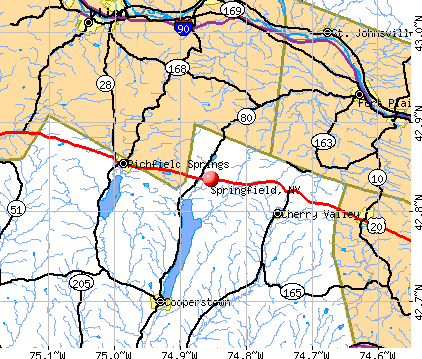
- OSM Map
- General Map
- Google Map
- MSN Map
Population change since 2000: +0.6%
 |
| Males: 698 | |
| Females: 660 |
| Median resident age: | 46.8 years |
| New York median age: | 40.7 years |
Zip codes: 13468.
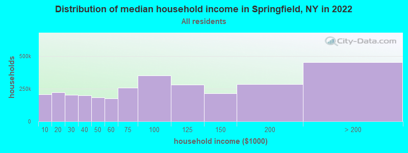
| Springfield: | $65,088 |
| NY: | $79,557 |
Estimated per capita income in 2022: $34,149 (it was $16,513 in 2000)
Springfield town income, earnings, and wages data
Estimated median house or condo value in 2022: $190,129 (it was $81,500 in 2000)
| Springfield: | $190,129 |
| NY: | $400,400 |
Mean prices in 2022: all housing units: $228,779; detached houses: $247,959; townhouses or other attached units: $313,844; in 2-unit structures: $212,590; in 3-to-4-unit structures: $357,277; in 5-or-more-unit structures: $928,498; mobile homes: $87,717
Detailed information about poverty and poor residents in Springfield, NY


- 1,31596.8%White alone
- 131.0%Hispanic
- 120.9%Two or more races
- 100.7%Black alone
- 50.4%Asian alone
- 20.1%American Indian alone
- 10.07%Other race alone
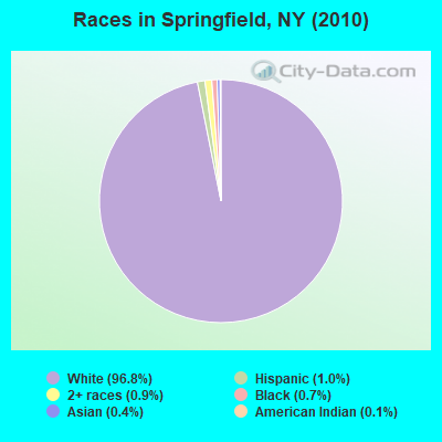
Races in Springfield detailed stats: ancestries, foreign born residents, place of birth
 Recent articles from our blog. Our writers, many of them Ph.D. graduates or candidates, create easy-to-read articles on a wide variety of topics.

 | Bills want new stadium to be completely funded by taxpayer money (998 replies) |
| Upper Middle class african-american communities in ny (2044 replies) |
| Anybody have some input on Albany, NY vs. Springfield, MA? (23 replies) |
| smaller Upstate NY cities and towns/African American communities (5974 replies) |
| Springfield Gardens Auto road test? (2 replies) |
| Safest Cities from natural disasters (70 replies) |
Latest news from Springfield, NY collected exclusively by city-data.com from local newspapers, TV, and radio stations
Ancestries: German (22.0%), English (20.6%), Irish (13.0%), Dutch (9.2%), Polish (5.2%), Scottish (5.1%).
Current Local Time: EST time zone
Elevation: 1340 feet
Land area: 43.0 square miles.
Population density: 32 people per square mile (very low).
64 residents are foreign born (2.7% Europe, 1.8% Latin America).
| This town: | 4.7% |
| New York: | 20.4% |
| Springfield town: | 1.2% ($995) |
| New York: | 1.9% ($2,847) |
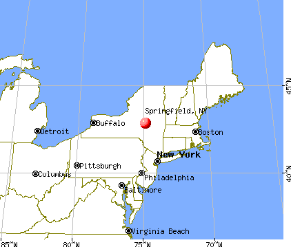
Nearest city with pop. 50,000+: Utica, NY  (26.1 miles , pop. 60,651).
Nearest city with pop. 200,000+: Rochester, NY (140.8 miles , pop. 219,773).
Nearest city with pop. 1,000,000+: Bronx, NY (146.5 miles , pop. 1,332,650).
Nearest cities:
), ), ), ), )Latitude: 42.83 N, Longitude: 74.87 W
Area code commonly used in this area: 607

| Here: | 4.7% |
| New York: | 4.4% |
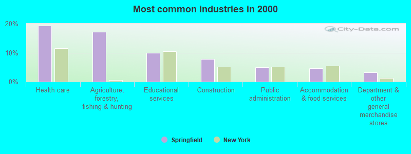
- Health care (19.2%)
- Agriculture, forestry, fishing & hunting (17.1%)
- Educational services (10.0%)
- Construction (7.8%)
- Public administration (4.9%)
- Accommodation & food services (4.6%)
- Department & other general merchandise stores (3.1%)
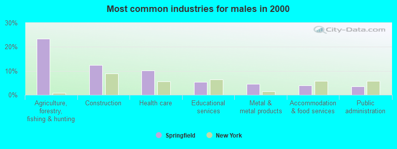
- Agriculture, forestry, fishing & hunting (23.3%)
- Construction (12.4%)
- Health care (10.1%)
- Educational services (5.5%)
- Metal & metal products (4.6%)
- Accommodation & food services (4.0%)
- Public administration (3.4%)
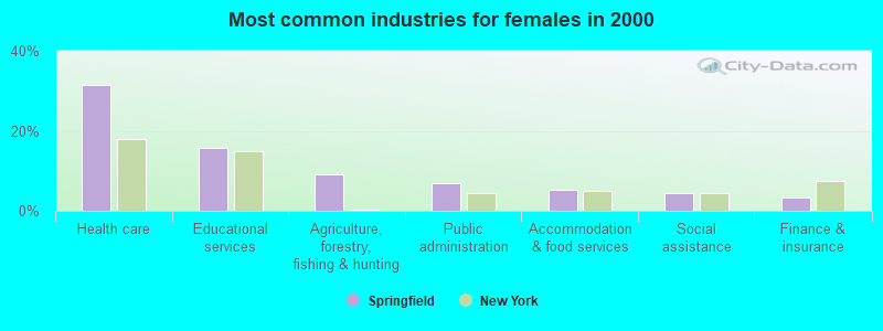
- Health care (31.3%)
- Educational services (15.8%)
- Agriculture, forestry, fishing & hunting (9.1%)
- Public administration (6.8%)
- Accommodation & food services (5.3%)
- Social assistance (4.5%)
- Finance & insurance (3.4%)
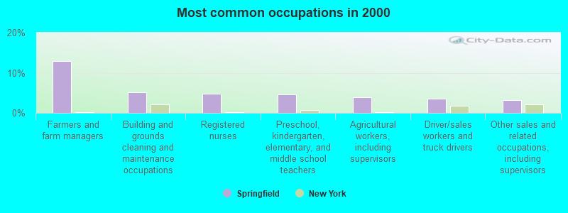
- Farmers and farm managers (12.9%)
- Building and grounds cleaning and maintenance occupations (5.2%)
- Registered nurses (4.7%)
- Preschool, kindergarten, elementary, and middle school teachers (4.6%)
- Agricultural workers, including supervisors (3.9%)
- Driver/sales workers and truck drivers (3.6%)
- Other sales and related occupations, including supervisors (3.3%)
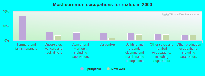
- Farmers and farm managers (17.2%)
- Driver/sales workers and truck drivers (5.7%)
- Agricultural workers, including supervisors (5.5%)
- Carpenters (5.2%)
- Building and grounds cleaning and maintenance occupations (4.9%)
- Other sales and related occupations, including supervisors (4.3%)
- Other production occupations, including supervisors (3.7%)
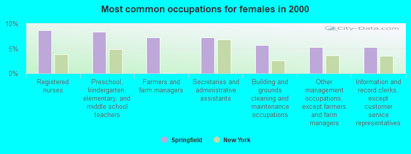
- Registered nurses (8.7%)
- Preschool, kindergarten, elementary, and middle school teachers (8.3%)
- Farmers and farm managers (7.2%)
- Secretaries and administrative assistants (7.2%)
- Building and grounds cleaning and maintenance occupations (5.7%)
- Other management occupations, except farmers and farm managers (5.3%)
- Information and record clerks, except customer service representatives (5.3%)
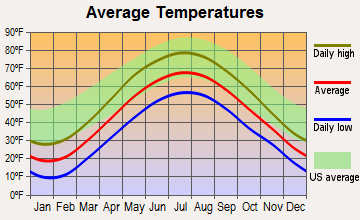
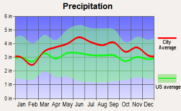
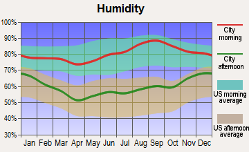
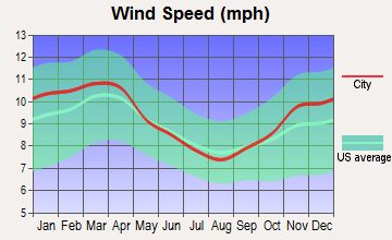
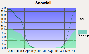
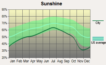
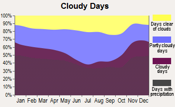
Average climate in Springfield, New York
Based on data reported by over 4,000 weather stations
Tornado activity:
Springfield-area historical tornado activity is slightly below New York state average. It is 67% smaller than the overall U.S. average.
On 7/10/1989, a category F4 (max. wind speeds 207-260 mph) tornado 17.0 miles away from the Springfield town center injured 20 people and caused between $5,000,000 and $50,000,000 in damages.
On 5/31/1998, a category F3 (max. wind speeds 158-206 mph) tornado 17.7 miles away from the town center injured 3 people and caused $800,000 in damages.
Earthquake activity:
Springfield-area historical earthquake activity is significantly above New York state average. It is 67% smaller than the overall U.S. average.On 10/7/1983 at 10:18:46, a magnitude 5.3 (5.1 MB, 5.3 LG, 5.1 ML, Class: Moderate, Intensity: VI - VII) earthquake occurred 81.9 miles away from the city center
On 4/20/2002 at 10:50:47, a magnitude 5.3 (5.3 ML, Depth: 3.0 mi) earthquake occurred 130.1 miles away from Springfield center
On 4/20/2002 at 10:50:47, a magnitude 5.2 (5.2 MB, 4.2 MS, 5.2 MW, 5.0 MW) earthquake occurred 128.1 miles away from the city center
On 6/17/1991 at 08:53:16, a magnitude 4.1 (4.0 MB, 4.0 LG, Depth: 3.1 mi, Class: Light, Intensity: IV - V) earthquake occurred 16.9 miles away from the city center
On 1/19/1982 at 00:14:42, a magnitude 4.7 (4.5 MB, 4.7 MD, 4.5 LG) earthquake occurred 171.1 miles away from Springfield center
On 8/23/2011 at 17:51:04, a magnitude 5.8 (5.8 MW, Depth: 3.7 mi) earthquake occurred 376.9 miles away from the city center
Magnitude types: regional Lg-wave magnitude (LG), body-wave magnitude (MB), duration magnitude (MD), local magnitude (ML), surface-wave magnitude (MS), moment magnitude (MW)
Natural disasters:
The number of natural disasters in Otsego County (22) is greater than the US average (15).Major Disasters (Presidential) Declared: 13
Emergencies Declared: 7
Causes of natural disasters: Storms: 10, Floods: 8, Hurricanes: 3, Snowstorms: 2, Tropical Storms: 2, Blizzard: 1, Ice Storm: 1, Power Outage: 1, Tornado: 1, Wind: 1, Winter Storm: 1, Other: 2 (Note: some incidents may be assigned to more than one category).

Hospitals and medical centers near Springfield:
- MARY IMOGENE BASSETT HOSPITAL (Dialysis Facility, about 10 miles away; COOPERSTOWN, NY)
- OTSEGO MANOR (Nursing Home, about 13 miles away; COOPERSTOWN, NY)
- ST JOHNSVILLE REHAB AND NURSING (Nursing Home, about 15 miles away; SAINT JOHNSVILLE, NY)
- BASSETT HEALTHCARE LITTLE FALLS DIALYSIS (Dialysis Facility, about 15 miles away; LITTLE FALLS, NY)
- LITTLE FALLS HOSPITAL Critical Access Hospitals (about 15 miles away; LITTLE FALLS, NY)
- FAXTON ST. LUKE'S HEALTHCARE - HERKIMER (Dialysis Facility, about 15 miles away; HERKIMER, NY)
- FOLTS HOME (Nursing Home, about 15 miles away; HERKIMER, NY)
Airports located in Springfield:
- De Ronda Airport (3NY3) (Runways: 1)
Colleges/universities with over 2000 students nearest to Springfield:
- Herkimer County Community College (about 16 miles; Herkimer, NY; Full-time enrollment: 2,774)
- SUNY College of Agriculture and Technology at Cobleskill (about 22 miles; Cobleskill, NY; FT enrollment: 2,455)
- Mohawk Valley Community College (about 25 miles; Utica, NY; FT enrollment: 5,693)
- SUNY Oneonta (about 28 miles; Oneonta, NY; FT enrollment: 6,081)
- Utica College (about 28 miles; Utica, NY; FT enrollment: 2,952)
- Fulton-Montgomery Community College (about 31 miles; Johnstown, NY; FT enrollment: 2,043)
- Colgate University (about 34 miles; Hamilton, NY; FT enrollment: 3,094)
Public high schools in Springfield:
- GEORGE WASHINGTON CARVER HIGH SCHOOL FOR THE SCIEN (Students: 437, Location: 143 10 SPRINGFIELD BLVD, Grades: 9-12)
- EXCELSIOR PREPARATORTY HIGH SCHOOL (Students: 415, Location: 143 10 SPRINGFIELD BLVD, Grades: 9-12)
- PREPARATORY ACADEMY FOR WRITERS: A COLLEGE BOARD (Students: 380, Location: 143 10 SPRINGFIELD BLVD, Grades: 6-12)
- QUEENS PREPARATORY ACADEMY (Students: 372, Location: 143 10 SPRINGFIELD BLVD, Grades: 9-12)
Private high school in Springfield:
- MARTIN DE PORRES SCHOOL (Students: 486, Location: 13625 218TH ST, Grades: 1-12)
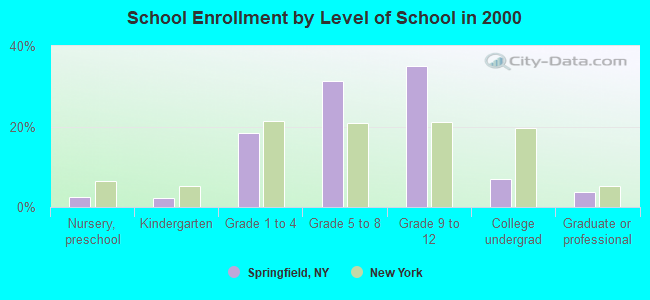
Biggest public elementary/middle schools in Springfield:
- IS 59 SPRINGFIELD GARDENS (Students: 829, Location: 132-55 RIDGEDALE ST, Grades: 6-8)
- PS 156 LAURELTON (Students: 803, Location: 229-02 137TH AVE, Grades: PK-8)
- PS 176 CAMBRIA HEIGHTS (Students: 760, Location: 132-55 RIDGEDALE ST, Grades: PK-5)
- MERRICK ACADEMY-QUEENS PUBLIC CHARTER SCHOOL (Students: 494, Location: 136-25 218TH ST, Grades: KG-6, Charter school)
- PS 15 JACKIE ROBINSON (Students: 438, Location: 121-15 LUCAS ST, Grades: PK-5)
- PS 181 BROOKFIELD (Students: 436, Location: 148-15 230TH ST, Grades: PK-5)
- PS 132 RALPH BUNCHE (Students: 395, Location: 132-15 218TH ST, Grades: PK-5)
- PS 251 (Students: 331, Location: 144-51 ARTHUR ST, Grades: PK-3)
- COLLABORATIVE ARTS MIDDLE SCHOOL (Location: 145-00 SPRINGFIELD BLVD, Grades: 6-8)
- COMMUNITY VOICES MIDDLE SCHOOL (Location: 145-00 SPRINGFIELD BLVD, Grades: 6-8)
Points of interest:
Notable locations in Springfield: Otsego Golf Club (A), Meadow Links Golf Course (B), Cooperstown Ringwood Farms Campground (C), Cooperstown Shadow Brook Campground (D). Display/hide their locations on the map
Cemeteries: Oliver Cemetery (1), Thurston Hill Cemetery (2), Springfield Cemetery (3), Middle Village Cemetery (4), Pumpkin Hook Cemetery (5). Display/hide their locations on the map
Lakes, reservoirs, and swamps: Shipman Pond (A), Summit Lake (B), Bailey Pond (C), Allen Lake (D), Clarke Pond (E), Cedar Swamp (F). Display/hide their locations on the map
Streams, rivers, and creeks: Cripple Creek (A), Shadow Brook (B), Hayden Creek (C). Display/hide their locations on the map
| This town: | 2.4 people |
| New York: | 2.6 people |
| This town: | 67.1% |
| Whole state: | 63.5% |
| This town: | 6.7% |
| Whole state: | 6.8% |
Likely homosexual households (counted as self-reported same-sex unmarried-partner households)
- Lesbian couples: 0.0% of all households
- Gay men: 0.5% of all households
| This town: | 8.5% |
| Whole state: | 14.6% |
| This town: | 2.5% |
| Whole state: | 7.4% |
For population 15 years and over in Springfield:
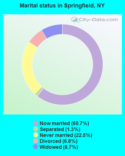
- Never married: 22.5%
- Now married: 60.7%
- Separated: 1.3%
- Widowed: 8.7%
- Divorced: 6.8%
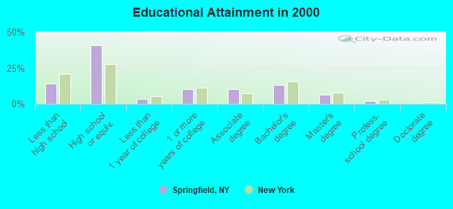
For population 25 years and over in Springfield:
- High school or higher: 85.8%
- Bachelor's degree or higher: 21.5%
- Graduate or professional degree: 8.5%
- Unemployed: 6.7%
- Mean travel time to work (commute): 23.7 minutes
| Here: | 11.0 |
| New York average: | 14.2 |
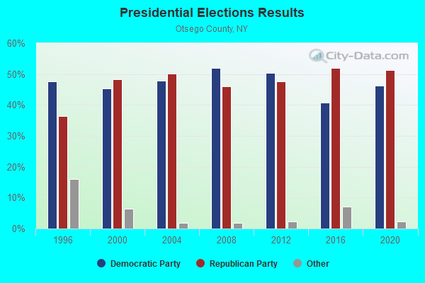
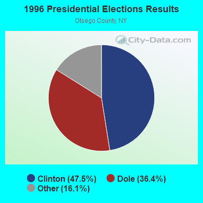
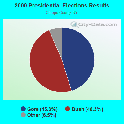
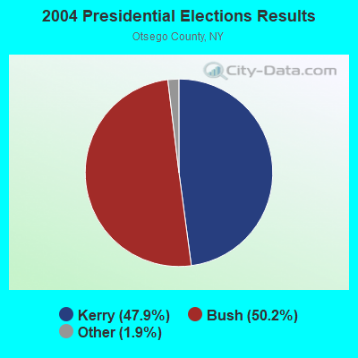
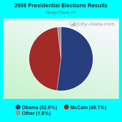
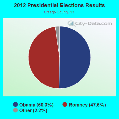
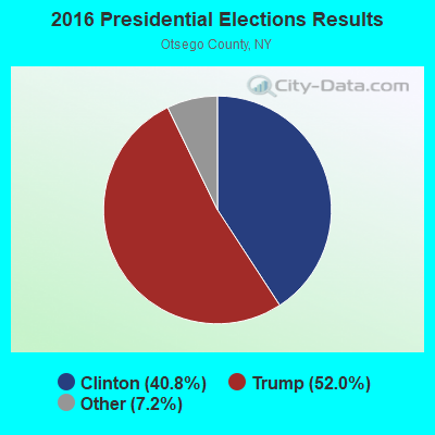
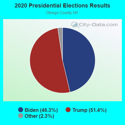
Graphs represent county-level data. Detailed 2008 Election Results
Religion statistics for Springfield, NY (based on Otsego County data)
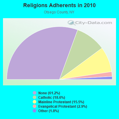
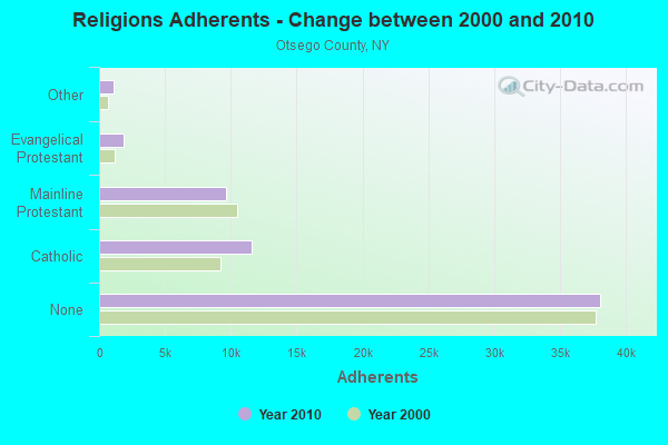
| Religion | Adherents | Congregations |
|---|---|---|
| Catholic | 11,599 | 6 |
| Mainline Protestant | 9,637 | 69 |
| Evangelical Protestant | 1,829 | 26 |
| Other | 1,094 | 9 |
| Orthodox | 25 | 1 |
| None | 38,075 | - |
Food Environment Statistics:
| Here: | 2.89 / 10,000 pop. |
| New York: | 4.13 / 10,000 pop. |
| Otsego County: | 0.32 / 10,000 pop. |
| State: | 0.06 / 10,000 pop. |
| Otsego County: | 0.96 / 10,000 pop. |
| New York: | 0.92 / 10,000 pop. |
| Otsego County: | 5.62 / 10,000 pop. |
| State: | 1.68 / 10,000 pop. |
| This county: | 9.96 / 10,000 pop. |
| New York: | 8.82 / 10,000 pop. |
| This county: | 7.7% |
| State: | 8.2% |
| This county: | 24.6% |
| State: | 23.8% |
| Otsego County: | 15.6% |
| New York: | 15.6% |
Strongest AM radio stations in Springfield:
- WGY (810 AM; 50 kW; SCHENECTADY, NY; Owner: CLEAR CHANNEL BROADCASTING LICENSES, INC.)
- WPTR (1540 AM; 50 kW; ALBANY, NY; Owner: KIMTRON, INC.)
- WTLB (1310 AM; 5 kW; UTICA, NY; Owner: GALAXY COMMUNICATIONS, L.P.)
- WIBX (950 AM; 5 kW; UTICA, NY; Owner: REGENT LICENSEE OF UTICA/ROME, INC.)
- WNNZ (640 AM; 50 kW; WESTFIELD, MA; Owner: CLEAR CHANNEL BROADCASTING LICENSES, INC.)
- WLFH (1230 AM; 1 kW; LITTLE FALLS, NY; Owner: CLEAR CHANNEL BROADCASTING LICENSES, INC.)
- WRUN (1150 AM; 5 kW; UTICA, NY)
- WMCA (570 AM; 50 kW; NEW YORK, NY; Owner: SALEM MEDIA OF NEW YORK, LLC)
- WFAN (660 AM; 50 kW; NEW YORK, NY; Owner: INFINITY BROADCASTING OPERATIONS, INC.)
- WABC (770 AM; 50 kW; NEW YORK, NY; Owner: WABC-AM RADIO, INC.)
- WOR (710 AM; 50 kW; NEW YORK, NY; Owner: BUCKLEY BROADCASTING CORPORATION)
- WTIC (1080 AM; 50 kW; HARTFORD, CT; Owner: INFINITY RADIO OPERATIONS INC.)
- WCBS (880 AM; 50 kW; NEW YORK, NY; Owner: INFINITY BROADCASTING OPERATIONS, INC.)
Strongest FM radio stations in Springfield:
- WJIV (101.9 FM; CHERRY VALLEY, NY; Owner: CHRISTIAN BROADCASTING SYSTEM, LTD.)
- WBUG-FM (101.1 FM; FORT PLAIN, NY; Owner: ROSER COMMUNICATIONS NETWORK, INC.)
- WSKU (105.5 FM; LITTLE FALLS, NY; Owner: CLEAR CHANNEL BROADCASTING LICENSES, INC.)
- WGKR (105.3 FM; GRAND GORGE, NY; Owner: SOUND OF LIFE, INC.)
- WBGK (99.7 FM; NEWPORT VILLAGE, NY; Owner: ROSER COMMUNICATIONS NETWORK, INC.)
- WOUR (96.9 FM; UTICA, NY; Owner: CLEAR CHANNEL BROADCASTING LICENSES, INC.)
- WUNY (89.5 FM; UTICA, NY; Owner: PUBLIC BC COUNCIL OF CENTRAL NY, INC)
- WKVU (100.7 FM; UTICA, NY; Owner: EDUCATIONAL MEDIA FOUNDATION)
- WQBJ (103.5 FM; COBLESKILL, NY; Owner: REGENT LICENSEE OF MANSFIELD, INC.)
- WLZW (98.7 FM; UTICA, NY; Owner: REGENT LICENSEE OF UTICA/ROME, INC.)
- WMYY (97.3 FM; SCHOHARIE, NY; Owner: CAPITAL MEDIA CORPORATION)
- WKLL (94.9 FM; FRANKFORT, NY; Owner: GALAXY COMMUNICATIONS, L.P.)
- WCAN (93.3 FM; CANAJOHARIE, NY; Owner: W A M C)
- WDHI (100.3 FM; DELHI, NY; Owner: BANJO COMMUNICATIONS GROUP, INC.)
- WAJZ (96.3 FM; VOORHEESVILLE, NY; Owner: 6 JOHNSON ROAD LICENSES, INC.)
- WSKS (97.9 FM; WHITESBORO, NY; Owner: CLEAR CHANNEL BROADCASTING LICENSES, INC.)
- WZMR (104.9 FM; ALTAMONT, NY; Owner: 6 JOHNSON ROAD LICENSES, INC.)
- WXUR (92.7 FM; HERKIMER, NY; Owner: ARJUNA BROADCASTING CORP.)
- WRCK (107.3 FM; UTICA, NY; Owner: GALAXY COMMUNICATIONS, L.P.)
- WRBY (102.5 FM; ROME, NY; Owner: CLEAR CHANNEL BROADCASTING LICENSES, INC.)
TV broadcast stations around Springfield:
- WKTV (Channel 2; UTICA, NY; Owner: SMITH TELEVISION OF NEW YORK LICENSE HOLDINGS, INC.)
- WFXV (Channel 33; UTICA, NY; Owner: QUORUM OF UTICA LICENSE, LLC)
- W31BP (Channel 31; BURLINGTON, ETC., NY; Owner: QUORUM OF UTICA LICENSE, LLC)
- WYPX (Channel 55; AMSTERDAM, NY; Owner: PAXSON ALBANY LICENSE, INC.)
- W59AU (Channel 59; UTICA, NY; Owner: PUBLIC B/CING.COUNCIL,CENTRAL N. Y.)
- WUTR (Channel 20; UTICA, NY; Owner: CENTRAL NY NEWS, INC.)
- W29BJ (Channel 29; BURLINGTON, NY; Owner: KEVIN O'KANE)
- National Bridge Inventory (NBI) Statistics
- 4Number of bridges
- 16ft / 5.2mTotal length
- $1,851,000Total costs
- 314Total average daily traffic
- 4Total average daily truck traffic
FCC Registered Broadcast Land Mobile Towers:
1- Lat: 40.677944 Lon: -73.755833, Call Sign: WQRY256,
Assigned Frequencies: 452.025 MHz, 457.337 MHz, 457.737 MHz, 469.150 MHz, Grant Date: 08/15/2023, Expiration Date: 08/14/2033, Certifier: John Mahanna, Registrant: United Parcel Service, Inc., 2200 Outer Loop, Louisville, KY 40219-3565, Phone: (502) 961-1406, Fax: (502) 374-2149, Email:
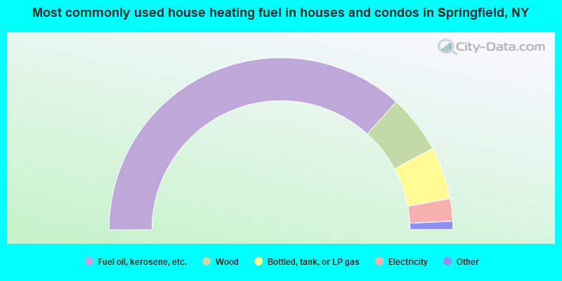
- 73.3%Fuel oil, kerosene, etc.
- 11.0%Wood
- 9.8%Bottled, tank, or LP gas
- 4.2%Electricity
- 1.2%Coal or coke
- 0.5%Other fuel
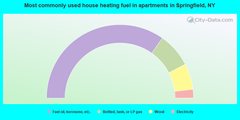
- 69.5%Fuel oil, kerosene, etc.
- 15.2%Bottled, tank, or LP gas
- 11.4%Wood
- 3.8%Electricity
Springfield compared to New York state average:
- Median house value below state average.
- Unemployed percentage below state average.
- Black race population percentage significantly below state average.
- Hispanic race population percentage significantly below state average.
- Median age above state average.
- Foreign-born population percentage significantly below state average.
- Renting percentage below state average.
- Length of stay since moving in significantly above state average.
- Number of rooms per house significantly below state average.
- House age significantly below state average.
- Number of college students below state average.