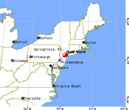
Springfield, New Jersey
Submit your own pictures of this place and show them to the world
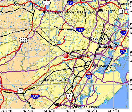
- OSM Map
- General Map
- Google Map
- MSN Map
| Males: 6,760 | |
| Females: 7,574 |
| Median resident age: | 42.1 years |
| New Jersey median age: | 36.7 years |
Zip codes: 07081.
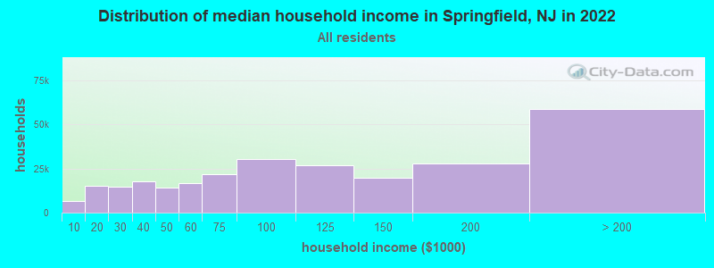
| Springfield: | $130,712 |
| NJ: | $96,346 |
Estimated per capita income in 2022: $71,090 (it was $36,754 in 2000)
Springfield CDP income, earnings, and wages data
Estimated median house or condo value in 2022: $662,399 (it was $245,500 in 2000)
| Springfield: | $662,399 |
| NJ: | $428,900 |
Mean prices in 2022: all housing units: $571,611; detached houses: $596,477; townhouses or other attached units: $609,757; in 2-unit structures: $452,159; in 3-to-4-unit structures: $316,757; in 5-or-more-unit structures: $383,498; mobile homes: $54,657
Detailed information about poverty and poor residents in Springfield, NJ


- 12,49186.6%White alone
- 6754.7%Asian alone
- 5974.1%Hispanic
- 5363.7%Black alone
- 1100.8%Two or more races
- 180.1%Other race alone
- 20.01%American Indian alone
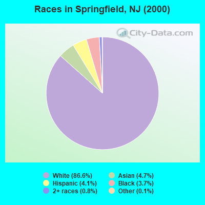
Races in Springfield detailed stats: ancestries, foreign born residents, place of birth
According to our research of New Jersey and other state lists, there was 1 registered sex offender living in Springfield, New Jersey as of May 06, 2024.
The ratio of all residents to sex offenders in Springfield is 14,334 to 1.
The ratio of registered sex offenders to all residents in this city is much lower than the state average.
Type |
2009 |
2010 |
2011 |
2012 |
2013 |
2014 |
2015 |
2016 |
2017 |
2018 |
2019 |
2020 |
2021 |
2022 |
|---|---|---|---|---|---|---|---|---|---|---|---|---|---|---|
| Murders (per 100,000) | 0 (0.0) | 0 (0.0) | 0 (0.0) | 0 (0.0) | 0 (0.0) | 0 (0.0) | 0 (0.0) | 2 (11.3) | 0 (0.0) | 0 (0.0) | 0 (0.0) | 0 (0.0) | 0 (0.0) | 0 (0.0) |
| Rapes (per 100,000) | 0 (0.0) | 0 (0.0) | 0 (0.0) | 1 (6.3) | 1 (5.8) | 0 (0.0) | 2 (11.4) | 6 (33.8) | 5 (28.1) | 0 (0.0) | 0 (0.0) | 1 (5.7) | 0 (0.0) | 1 (5.9) |
| Robberies (per 100,000) | 8 (53.8) | 4 (25.3) | 5 (31.5) | 3 (18.8) | 6 (34.8) | 0 (0.0) | 2 (11.4) | 6 (33.8) | 1 (5.6) | 1 (5.6) | 2 (11.3) | 5 (28.3) | 1 (5.5) | 1 (5.9) |
| Assaults (per 100,000) | 2 (13.4) | 5 (31.6) | 4 (25.2) | 0 (0.0) | 5 (29.0) | 2 (11.7) | 3 (17.1) | 1 (5.6) | 5 (28.1) | 3 (16.9) | 1 (5.7) | 7 (39.7) | 7 (38.3) | 8 (47.4) |
| Burglaries (per 100,000) | 34 (228.6) | 34 (215.0) | 35 (220.5) | 29 (181.4) | 38 (220.4) | 23 (134.5) | 17 (97.0) | 28 (157.6) | 24 (134.8) | 22 (123.9) | 19 (107.6) | 17 (96.4) | 16 (87.5) | 18 (106.8) |
| Thefts (per 100,000) | 218 (1,466) | 162 (1,024) | 202 (1,273) | 162 (1,013) | 159 (922.4) | 135 (789.3) | 158 (901.9) | 131 (737.4) | 108 (606.6) | 113 (636.2) | 105 (594.5) | 119 (674.6) | 157 (858.6) | 186 (1,103) |
| Auto thefts (per 100,000) | 16 (107.6) | 15 (94.8) | 17 (107.1) | 10 (62.6) | 14 (81.2) | 7 (40.9) | 5 (28.5) | 12 (67.6) | 10 (56.2) | 9 (50.7) | 10 (56.6) | 14 (79.4) | 30 (164.1) | 30 (177.9) |
| Arson (per 100,000) | 1 (6.7) | 2 (12.6) | 0 (0.0) | 0 (0.0) | 0 (0.0) | 1 (5.8) | 0 (0.0) | 0 (0.0) | 0 (0.0) | 0 (0.0) | 0 (0.0) | 0 (0.0) | 0 (0.0) | 2 (11.9) |
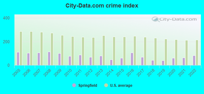
| City-Data.com crime index | 102.1 | 77.5 | 89.4 | 68.9 | 79.7 | 46.6 | 61.1 | 106.7 | 68.0 | 43.2 | 40.4 | 61.1 | 62.9 | 81.9 |
The City-Data.com crime index weighs serious crimes and violent crimes more heavily. Higher means more crime, U.S. average is 246.1. It adjusts for the number of visitors and daily workers commuting into cities.
Crime rate in Springfield detailed stats: murders, rapes, robberies, assaults, burglaries, thefts, arson
Full-time law enforcement employees in 2021, including police officers: 48 (44 officers - 38 male; 6 female).
| Officers per 1,000 residents here: | 2.41 |
| New Jersey average: | 5.53 |
 Recent articles from our blog. Our writers, many of them Ph.D. graduates or candidates, create easy-to-read articles on a wide variety of topics.

 | Clark vs Springfield (0 replies) |
| Community Hills in Newark (Springfield/Belmont)? (0 replies) |
| Millburn and Short Hills (10 replies) |
| Springfield nj (11 replies) |
| Is Springfield, NJ one of the few true middle class towns left? (52 replies) |
| Springfield, NJ - what's it like? (3 replies) |
Latest news from Springfield, NJ collected exclusively by city-data.com from local newspapers, TV, and radio stations
Ancestries: Italian (21.0%), German (10.7%), Russian (10.3%), Irish (10.2%), Polish (9.2%), United States (4.8%).
Current Local Time: EST time zone
Land area: 5.15 square miles.
Population density: 2,783 people per square mile (average).
2,937 residents are foreign born (10.7% Europe, 4.4% Asia, 3.7% Latin America).
| This place: | 20.4% |
| New Jersey: | 17.5% |
| Springfield CDP: | 2.1% ($5,271) |
| New Jersey: | 2.4% ($4,047) |
Nearest city with pop. 50,000+: Union, NJ  (2.7 miles , pop. 54,405).
Nearest city with pop. 200,000+: Newark, NJ (7.6 miles , pop. 273,546).
Nearest city with pop. 1,000,000+: Manhattan, NY (18.9 miles , pop. 1,537,195).
Nearest cities:
), ), ), Latitude: 40.70 N, Longitude: 74.32 W
Daytime population change due to commuting: +2,926 (+20.3%)
Workers who live and work in this place: 1,097 (14.7%)

Springfield, New Jersey accommodation & food services, waste management - Economy and Business Data
| Here: | 4.7% |
| New Jersey: | 4.5% |
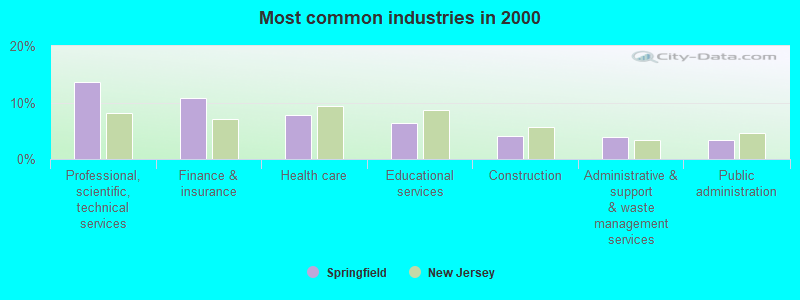
- Professional, scientific, technical services (13.7%)
- Finance & insurance (10.8%)
- Health care (7.9%)
- Educational services (6.4%)
- Construction (4.1%)
- Administrative & support & waste management services (4.0%)
- Public administration (3.4%)
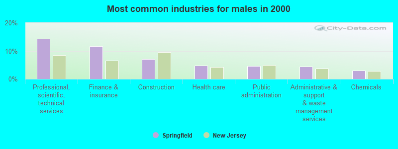
- Professional, scientific, technical services (14.3%)
- Finance & insurance (11.6%)
- Construction (7.1%)
- Health care (4.8%)
- Public administration (4.7%)
- Administrative & support & waste management services (4.5%)
- Chemicals (3.1%)
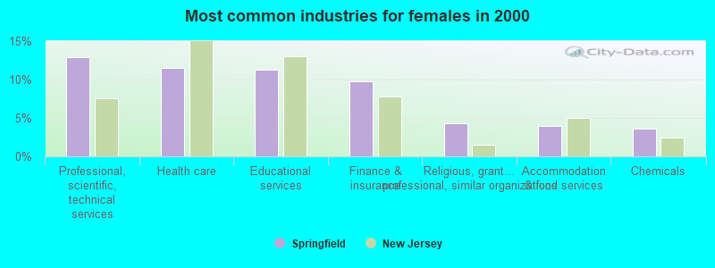
- Professional, scientific, technical services (12.9%)
- Health care (11.5%)
- Educational services (11.3%)
- Finance & insurance (9.8%)
- Religious, grantmaking, civic, professional, similar organizations (4.3%)
- Accommodation & food services (3.9%)
- Chemicals (3.6%)
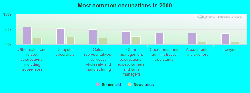
- Other sales and related occupations, including supervisors (5.8%)
- Computer specialists (5.4%)
- Sales representatives, services, wholesale and manufacturing (5.0%)
- Other management occupations, except farmers and farm managers (4.3%)
- Secretaries and administrative assistants (3.8%)
- Accountants and auditors (3.8%)
- Lawyers (3.6%)
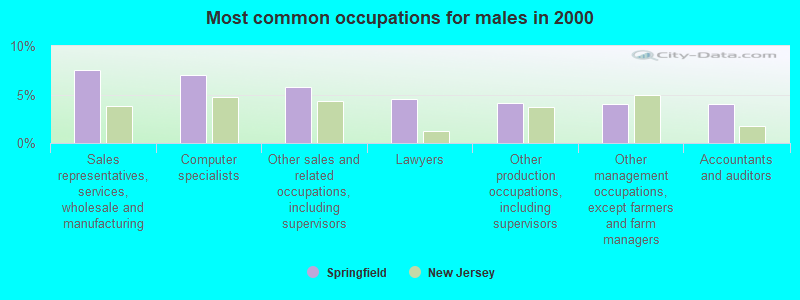
- Sales representatives, services, wholesale and manufacturing (7.5%)
- Computer specialists (7.0%)
- Other sales and related occupations, including supervisors (5.8%)
- Lawyers (4.5%)
- Other production occupations, including supervisors (4.1%)
- Other management occupations, except farmers and farm managers (4.1%)
- Accountants and auditors (4.0%)
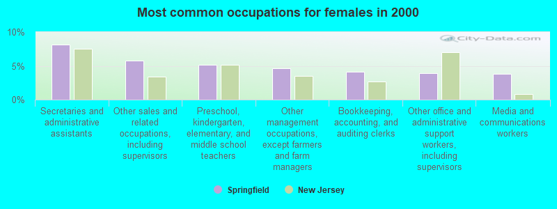
- Secretaries and administrative assistants (8.1%)
- Other sales and related occupations, including supervisors (5.7%)
- Preschool, kindergarten, elementary, and middle school teachers (5.1%)
- Other management occupations, except farmers and farm managers (4.6%)
- Bookkeeping, accounting, and auditing clerks (4.1%)
- Other office and administrative support workers, including supervisors (3.9%)
- Media and communications workers (3.8%)
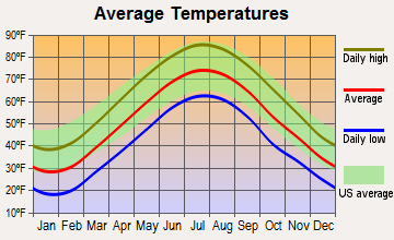
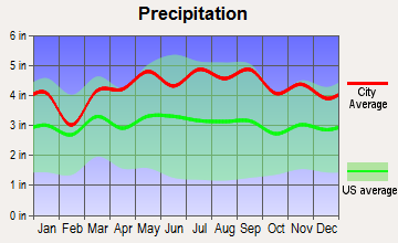
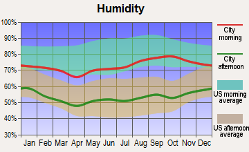
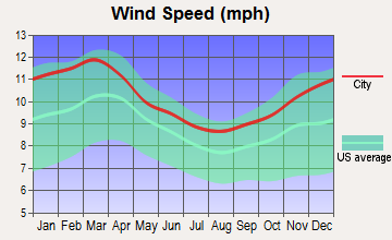
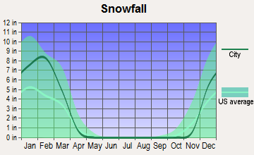
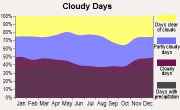
Average climate in Springfield, New Jersey
Based on data reported by over 4,000 weather stations

|
|


(lower is better)
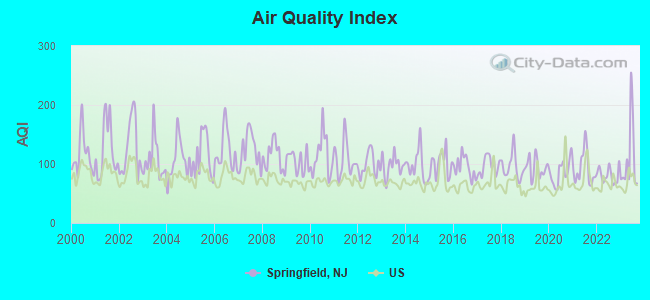
Air Quality Index (AQI) level in 2023 was 109. This is significantly worse than average.
| City: | 109 |
| U.S.: | 73 |
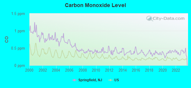
Carbon Monoxide (CO) [ppm] level in 2023 was 0.374. This is significantly worse than average. Closest monitor was 6.3 miles away from the city center.
| City: | 0.374 |
| U.S.: | 0.251 |
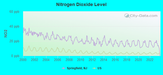
Nitrogen Dioxide (NO2) [ppb] level in 2023 was 15.0. This is significantly worse than average. Closest monitor was 6.6 miles away from the city center.
| City: | 15.0 |
| U.S.: | 5.1 |
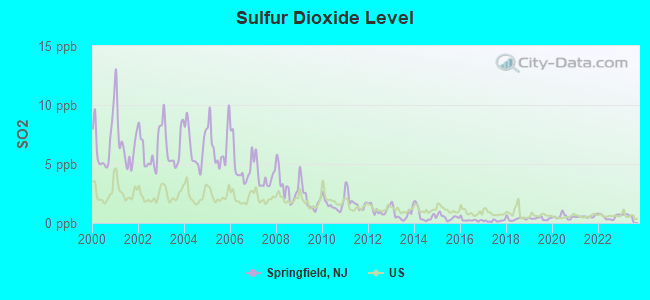
Sulfur Dioxide (SO2) [ppb] level in 2023 was 0.601. This is significantly better than average. Closest monitor was 5.3 miles away from the city center.
| City: | 0.601 |
| U.S.: | 1.515 |
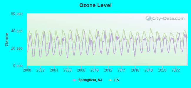
Ozone [ppb] level in 2023 was 29.8. This is about average. Closest monitor was 6.9 miles away from the city center.
| City: | 29.8 |
| U.S.: | 33.3 |
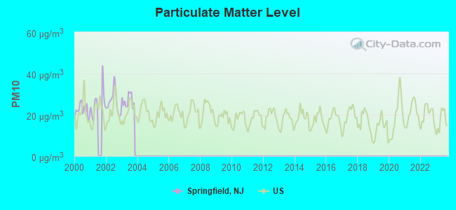
Particulate Matter (PM10) [µg/m3] level in 2003 was 26.9. This is worse than average. Closest monitor was 6.9 miles away from the city center.
| City: | 26.9 |
| U.S.: | 19.2 |
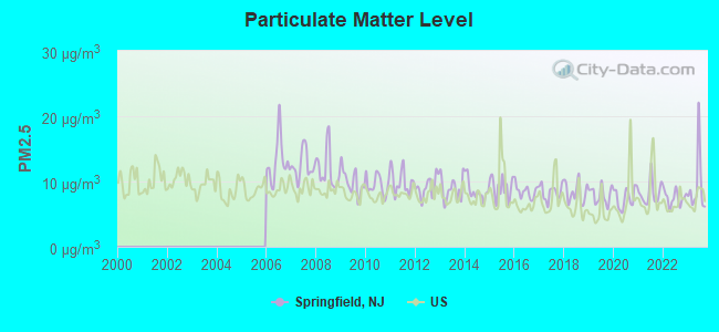
Particulate Matter (PM2.5) [µg/m3] level in 2023 was 9.29. This is about average. Closest monitor was 6.0 miles away from the city center.
| City: | 9.29 |
| U.S.: | 8.11 |
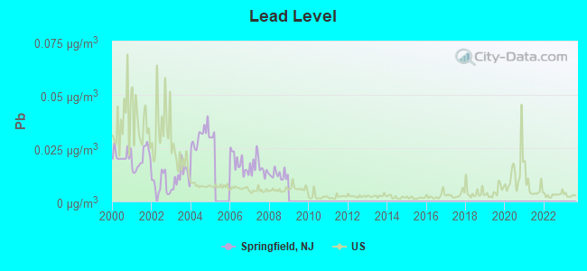
Lead (Pb) [µg/m3] level in 2008 was 0.0125. This is worse than average. Closest monitor was 6.5 miles away from the city center.
| City: | 0.0125 |
| U.S.: | 0.0093 |
Tornado activity:
Springfield-area historical tornado activity is near New Jersey state average. It is 32% smaller than the overall U.S. average.
On 5/28/1973, a category F3 (max. wind speeds 158-206 mph) tornado 11.5 miles away from the Springfield place center caused between $50,000 and $500,000 in damages.
On 5/28/1973, a category F3 tornado 23.2 miles away from the place center injured 12 people and caused between $50,000 and $500,000 in damages.
Earthquake activity:
Springfield-area historical earthquake activity is significantly above New Jersey state average. It is 68% smaller than the overall U.S. average.On 8/23/2011 at 17:51:04, a magnitude 5.8 (5.8 MW, Depth: 3.7 mi, Class: Moderate, Intensity: VI - VII) earthquake occurred 273.3 miles away from Springfield center
On 10/7/1983 at 10:18:46, a magnitude 5.3 (5.1 MB, 5.3 LG, 5.1 ML) earthquake occurred 224.9 miles away from Springfield center
On 1/16/1994 at 01:49:16, a magnitude 4.6 (4.6 MB, 4.6 LG, Depth: 3.1 mi, Class: Light, Intensity: IV - V) earthquake occurred 93.8 miles away from Springfield center
On 4/20/2002 at 10:50:47, a magnitude 5.3 (5.3 ML, Depth: 3.0 mi) earthquake occurred 265.5 miles away from the city center
On 4/20/2002 at 10:50:47, a magnitude 5.2 (5.2 MB, 4.2 MS, 5.2 MW, 5.0 MW) earthquake occurred 263.6 miles away from the city center
On 1/16/1994 at 00:42:43, a magnitude 4.2 (4.2 MB, 4.0 LG, Depth: 3.1 mi) earthquake occurred 92.3 miles away from the city center
Magnitude types: regional Lg-wave magnitude (LG), body-wave magnitude (MB), local magnitude (ML), surface-wave magnitude (MS), moment magnitude (MW)
Natural disasters:
The number of natural disasters in Union County (27) is a lot greater than the US average (15).Major Disasters (Presidential) Declared: 17
Emergencies Declared: 10
Causes of natural disasters: Floods: 7, Hurricanes: 7, Storms: 6, Heavy Rains: 4, Snowstorms: 3, Blizzards: 2, Water Shortages: 2, Winter Storms: 2, Power Outage: 1, Tornado: 1, Wind: 1, Other: 3 (Note: some incidents may be assigned to more than one category).
Main business address for: VILLAGE SUPER MARKET INC (RETAIL-GROCERY STORES).
Hospitals and medical centers near Springfield:
- ATLANTIC HOME CARE AND HOSPICE (Home Health Center, about 2 miles away; MILLBURN, NJ)
- VNS NEIGHBORHOOD ASSN OF MILBURN (Home Health Center, about 2 miles away; MILLBURN, NJ)
- DVA SUMMIT DIALYSIS CTR (Dialysis Facility, about 2 miles away; MOUNTAINSIDE, NJ)
- FMC HILLSIDE DIALYSIS CTR (Dialysis Facility, about 2 miles away; UNION, NJ)
- SOUTH MOUNTAIN HC (Nursing Home, about 3 miles away; VAUXHALL, NJ)
- SUMMIT OAKS HOSPITAL (Hospital, about 3 miles away; SUMMIT, NJ)
- CHILDRENS SPECIALIZED HOSPITAL MOUNTAINSIDE (Nursing Home, about 3 miles away; MOUNTAINSIDE, NJ)
Amtrak stations near Springfield:
- 7 miles: NEWARK INTERNATIONAL AIRPORT (NEWARK, ) . Services: ticket office, enclosed waiting area, public restrooms, public payphones.
- 9 miles: NEWARK (RAYMOND PLAZA WEST) . Services: ticket office, fully wheelchair accessible, enclosed waiting area, public restrooms, public payphones, snack bar, ATM, paid short-term parking, paid long-term parking, call for car rental service, taxi stand, intercity bus service, public transit connection.
- 10 miles: METROPARK (ISELIN, 100 MIDDLESEX-ESSEX TPK.) . Services: ticket office, fully wheelchair accessible, enclosed waiting area, public restrooms, public payphones, paid short-term parking, call for car rental service, taxi stand, public transit connection.
Colleges/universities with over 2000 students nearest to Springfield:
- Union County College (about 3 miles; Cranford, NJ; Full-time enrollment: 9,148)
- Seton Hall University (about 5 miles; South Orange, NJ; FT enrollment: 7,742)
- Kean University (about 5 miles; Union, NJ; FT enrollment: 12,648)
- Drew University (about 7 miles; Madison, NJ; FT enrollment: 2,272)
- University of Medicine and Dentistry of New Jersey (about 8 miles; Newark, NJ; FT enrollment: 3,210)
- Fairleigh Dickinson University-College at Florham (about 8 miles; Madison, NJ; FT enrollment: 2,690)
- Essex County College (about 8 miles; Newark, NJ; FT enrollment: 9,595)
Public high school in Springfield:
- JONATHAN DAYTON HIGH SCHOOL (Students: 541, Location: 139 MOUNTAIN AVE., Grades: 9-12)
Public elementary/middle schools in Springfield:
- EDWARD V. WALTON PRIMARY SCHOOL (Students: 589, Location: 601 MOUNTAIN AVE., Grades: PK-2)
- FLORENCE M. GAUDINEER MIDDLE SCHOOL (Students: 459, Location: 75 SOUTH SPRINGFIELD AVE., Grades: 6-8)
- THELMA L. SANDMEIER ELEMENTARY SCHOOL (Students: 245, Location: 666 SOUTH SPRINGFIELD AVE., Grades: 3-5)
- JAMES CALDWELL ELEMENTARY SCHOOL (Students: 221, Location: 36 CALDWELL PLACE, Grades: 3-5)
Private elementary/middle school in Springfield:
User-submitted facts and corrections:
- Overlook Hospital part of Atlantic Healthcare System is the closest hospital to Springfield, located in Summit, NJ
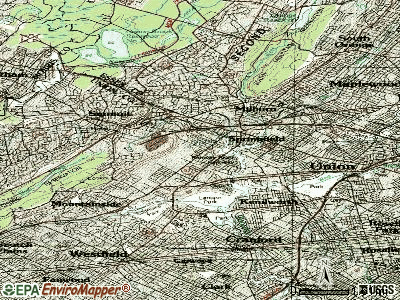
Points of interest:
Notable locations in Springfield: Baltusrol Station (A), Baltusrol Golf Course (B), Springfield Station (C), Springfield First Aid Squad (D), Springfield Fire Department (E). Display/hide their locations on the map
Shopping Center: Echo Plaza Shopping Center (1). Display/hide its location on the map
Main business address in Springfield: VILLAGE SUPER MARKET INC (A). Display/hide its location on the map
Church in Springfield: Echo Lake Church (A). Display/hide its location on the map
Parks in Springfield include: Lenape Park (1), Hidden Valley Park (2), Henshaw Playground (3), Rahway River Parkway (4), Irwin Playground (5). Display/hide their locations on the map
Hotel: Colonial Motor Court (75 US Highway 22).
Court: N J State - Judiciary Department- Appellate Div- Judges- Civil Appeals Settlement Pro (155 Morris Avenue).
Birthplace of: Jeff Ross - Stand-up comedian, Toni Kalem - Actor.
| This place: | 2.4 people |
| New Jersey: | 2.7 people |
| This place: | 66.9% |
| Whole state: | 70.7% |
| This place: | 3.0% |
| Whole state: | 4.9% |
Likely homosexual households (counted as self-reported same-sex unmarried-partner households)
- Lesbian couples: 0.2% of all households
- Gay men: 0.2% of all households
| This place: | 3.1% |
| Whole state: | 8.5% |
| This place: | 1.3% |
| Whole state: | 4.2% |
Banks with most branches in Springfield (2011 data):
- Investors Bank: 173 Mountain Avenue Branch at 173 Mountain Avenue, branch established on 1926/01/01; Springfield Branch at 193 Morris Avenue, branch established on 1939/09/28. Info updated 2012/02/27: Bank assets: $10,674.9 mil, Deposits: $7,419.7 mil, headquarters in Short Hills, NJ, positive income, Commercial Lending Specialization, 86 total offices, Holding Company: Investors Bancorp, Mhc
- TD Bank, National Association: Springfield Circle Branch at 166 Morris Avenue, branch established on 2002/12/14; Springfield/Union County Branch at 540 Morris Avenue, branch established on 2000/08/05. Info updated 2010/10/04: Bank assets: $188,912.6 mil, Deposits: $153,149.8 mil, headquarters in Wilmington, DE, positive income, 1314 total offices, Holding Company: Toronto-Dominion Bank, The
- Union Center National Bank: Springfield Branch at 783 Mountain Avenue, branch established on 1977/01/31. Info updated 2006/11/03: Bank assets: $1,432.2 mil, Deposits: $1,123.5 mil, headquarters in Union, NJ, positive income, Commercial Lending Specialization, 11 total offices, Holding Company: Center Bancorp, Inc.
- Valley National Bank: Springfield Branch at 223 Mountain Avenue, branch established on 1999/04/01. Info updated 2012/01/10: Bank assets: $14,186.7 mil, Deposits: $9,715.7 mil, headquarters in Wayne, NJ, positive income, Commercial Lending Specialization, 219 total offices, Holding Company: Valley National Bancorp
- Bank of America, National Association: Springfield Branch at 175 Morris Avenue, branch established on 1908/01/01. Info updated 2009/11/18: Bank assets: $1,451,969.3 mil, Deposits: $1,077,176.8 mil, headquarters in Charlotte, NC, positive income, 5782 total offices, Holding Company: Bank Of America Corporation
- Community First Bank: Springfield Branch at 899 Mountain Avenue, branch established on 2011/02/28. Info updated 2012/04/03: Bank assets: $63.7 mil, Deposits: $55.4 mil, headquarters in Somerset, NJ, negative income in the last year, Commercial Lending Specialization, 2 total offices
- Citibank, National Association: Springfield Branch at 275 Us Highway 22, branch established on 2007/01/08. Info updated 2012/01/10: Bank assets: $1,288,658.0 mil, Deposits: $882,541.0 mil, headquarters in Sioux Falls, SD, positive income, International Specialization, 1048 total offices, Holding Company: Citigroup Inc.
- Wells Fargo Bank, National Association: Route 22 Springfield Branch at 222 West Us Highway 22, branch established on 1970/01/31. Info updated 2011/04/05: Bank assets: $1,161,490.0 mil, Deposits: $905,653.0 mil, headquarters in Sioux Falls, SD, positive income, 6395 total offices, Holding Company: Wells Fargo & Company
- Kearny Federal Savings Bank: Springfield Branch at 130 Mountain Avenue, branch established on 1943/11/01. Info updated 2011/07/21: Bank assets: $2,851.0 mil, Deposits: $2,123.4 mil, headquarters in Kearny, NJ, positive income, Mortgage Lending Specialization, 41 total offices
For population 15 years and over in Springfield:

- Never married: 20.7%
- Now married: 63.0%
- Separated: 1.0%
- Widowed: 8.9%
- Divorced: 6.4%
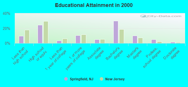
For population 25 years and over in Springfield:
- High school or higher: 90.3%
- Bachelor's degree or higher: 46.7%
- Graduate or professional degree: 16.8%
- Unemployed: 1.5%
- Mean travel time to work (commute): 27.1 minutes
| Here: | 11.7 |
| New Jersey average: | 13.1 |
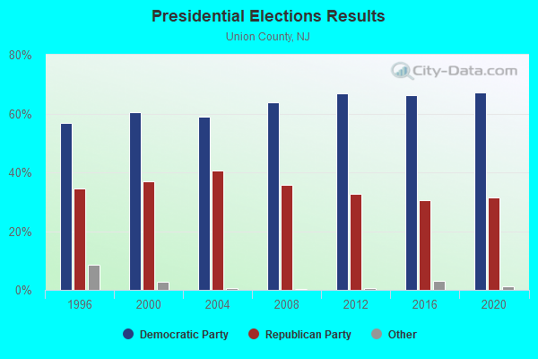
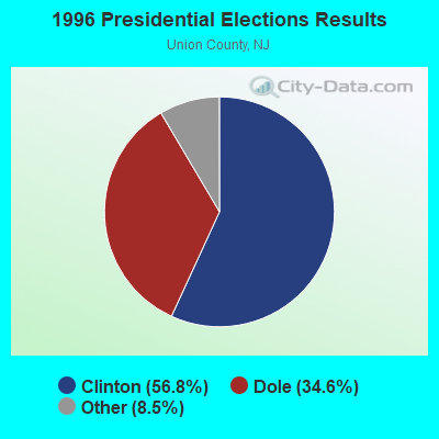
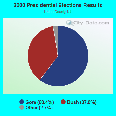
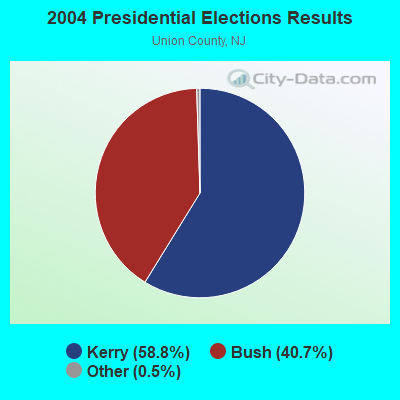
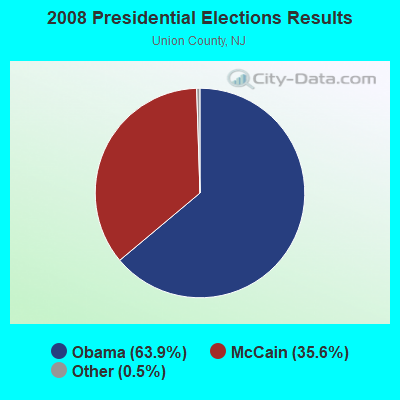
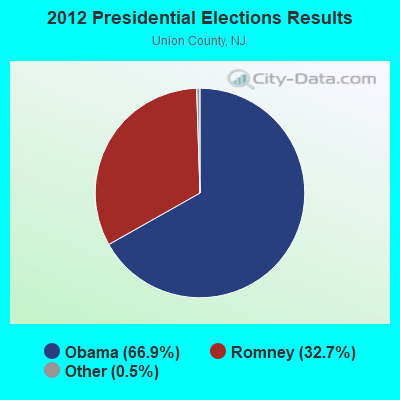
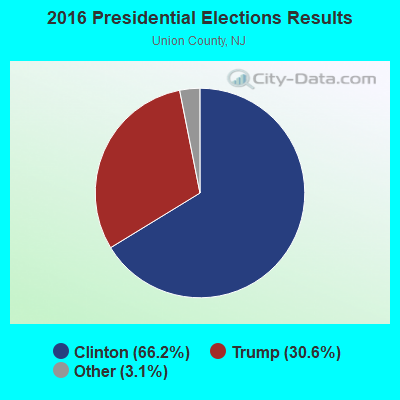

Graphs represent county-level data. Detailed 2008 Election Results
Religion statistics for Springfield, NJ (based on Union County data)
| Religion | Adherents | Congregations |
|---|---|---|
| Catholic | 247,240 | 44 |
| Mainline Protestant | 35,313 | 109 |
| Evangelical Protestant | 30,123 | 129 |
| Other | 28,707 | 52 |
| Black Protestant | 7,858 | 38 |
| Orthodox | 5,717 | 10 |
| None | 181,541 | - |
Food Environment Statistics:
| Union County: | 2.97 / 10,000 pop. |
| New Jersey: | 2.90 / 10,000 pop. |
| This county: | 0.04 / 10,000 pop. |
| New Jersey: | 0.06 / 10,000 pop. |
| Here: | 1.80 / 10,000 pop. |
| New Jersey: | 1.76 / 10,000 pop. |
| This county: | 0.75 / 10,000 pop. |
| New Jersey: | 0.81 / 10,000 pop. |
| Here: | 7.38 / 10,000 pop. |
| New Jersey: | 7.15 / 10,000 pop. |
| Union County: | 8.3% |
| New Jersey: | 8.3% |
| Here: | 21.1% |
| New Jersey: | 23.3% |
| This county: | 21.4% |
| New Jersey: | 18.0% |
6.55% of this county's 2021 resident taxpayers lived in other counties in 2020 ($90,395 average adjusted gross income)
| Here: | 6.55% |
| New Jersey average: | 6.70% |
0.02% of residents moved from foreign countries ($49 average AGI)
Union County: 0.02% New Jersey average: 0.01%
Top counties from which taxpayers relocated into this county between 2020 and 2021:
| from Essex County, NJ | |
| from Hudson County, NJ | |
| from Middlesex County, NJ |
7.45% of this county's 2020 resident taxpayers moved to other counties in 2021 ($103,155 average adjusted gross income)
| Here: | 7.45% |
| New Jersey average: | 7.02% |
0.01% of residents moved to foreign countries ($81 average AGI)
Union County: 0.01% New Jersey average: 0.02%
Top counties to which taxpayers relocated from this county between 2020 and 2021:
| to Middlesex County, NJ | |
| to Essex County, NJ | |
| to Somerset County, NJ |
| Businesses in Springfield, NJ | ||||
| Name | Count | Name | Count | |
|---|---|---|---|---|
| 7-Eleven | 2 | Nike | 1 | |
| BMW | 1 | Nissan | 1 | |
| Bally Total Fitness | 1 | Olive Garden | 1 | |
| Barnes & Noble | 1 | Outback | 1 | |
| Baskin-Robbins | 2 | Outback Steakhouse | 1 | |
| Bed Bath & Beyond | 1 | Panera Bread | 1 | |
| Chipotle | 1 | Pier 1 Imports | 1 | |
| DHL | 1 | Rite Aid | 1 | |
| Domino's Pizza | 1 | Skechers USA | 1 | |
| Dunkin Donuts | 3 | Staples | 1 | |
| FedEx | 5 | T.G.I. Driday's | 1 | |
| Firestone Complete Auto Care | 1 | Taco Bell | 1 | |
| GNC | 1 | Toyota | 1 | |
| GameStop | 1 | True Value | 1 | |
| Goodwill | 1 | UPS | 6 | |
| LensCrafters | 1 | YMCA | 1 | |
| Macy's | 1 | |||
Strongest AM radio stations in Springfield:
- WMCA (570 AM; 50 kW; NEW YORK, NY; Owner: SALEM MEDIA OF NEW YORK, LLC)
- WOR (710 AM; 50 kW; NEW YORK, NY; Owner: BUCKLEY BROADCASTING CORPORATION)
- WINS (1010 AM; 50 kW; NEW YORK, NY; Owner: INFINITY BROADCASTING OPERATIONS, INC.)
- WJDM (1530 AM; 10 kW; ELIZABETH, NJ; Owner: RADIO UNICA OF NEW YORK LICENSE CORP)
- WEPN (1050 AM; 50 kW; NEW YORK, NY; Owner: NEW YORK AM RADIO, LLC)
- WNSW (1430 AM; 5 kW; NEWARK, NJ; Owner: MULTICULTURAL RADIO BROADCASTING INC)
- WABC (770 AM; 50 kW; NEW YORK, NY; Owner: WABC-AM RADIO, INC.)
- WADO (1280 AM; 50 kW; NEW YORK, NY; Owner: WADO-AM LICENSE CORP.)
- WBBR (1130 AM; 50 kW; NEW YORK, NY; Owner: BLOOMBERG COMMUNICATIONS INC.)
- WLIB (1190 AM; 30 kW; NEW YORK, NY; Owner: ICBC BROADCAST HOLDINGS-NY, INC.)
- WSNR (620 AM; 20 kW; JERSEY CITY, NJ)
- WNYC (820 AM; 10 kW; NEW YORK, NY; Owner: WNYC RADIO)
- WFAN (660 AM; 50 kW; NEW YORK, NY; Owner: INFINITY BROADCASTING OPERATIONS, INC.)
Strongest FM radio stations in Springfield:
- WRKS (98.7 FM; NEW YORK, NY; Owner: EMMIS RADIO LICENSE CORP OF NEW YORK)
- WNEW (102.7 FM; NEW YORK, NY; Owner: INFINITY BROADCASTING OPERATIONS, INC.)
- WFME (94.7 FM; NEWARK, NJ; Owner: FAMILY STATIONS, INC.)
- WFMU (91.1 FM; EAST ORANGE, NJ; Owner: AURICLE COMMUNICATIONS)
- WSOU (89.5 FM; SOUTH ORANGE, NJ; Owner: SETON HALL UNIVERSITY)
- WNYC-FM (93.9 FM; NEW YORK, NY; Owner: WNYC RADIO)
- WPAT-FM (93.1 FM; PATERSON, NJ; Owner: WPAT LICENSING, INC.)
- WQCD (101.9 FM; NEW YORK, NY; Owner: EMMIS RADIO LICENSE CORPORATION)
- WKTU (103.5 FM; LAKE SUCCESS, NY; Owner: AMFM RADIO LICENSES, LLC)
- WCAA (105.9 FM; NEWARK, NJ; Owner: WADO-AM LICENSE CORP. ("WADO"))
- WBAI (99.5 FM; NEW YORK, NY; Owner: PACIFICA FOUNDATION, INC.)
- WBLS (107.5 FM; NEW YORK, NY; Owner: ICBC BROADCAST HOLDINGS-NY, INC.)
- WLTW (106.7 FM; NEW YORK, NY; Owner: AMFM NEW YORK LICENSES, LLC)
- WQXR-FM (96.3 FM; NEW YORK, NY; Owner: THE NEW YORK TIMES ELECTRONIC MEDIA COMPANY)
- WSKQ-FM (97.9 FM; NEW YORK, NY; Owner: WSKQ LICENSING, INC.)
- WXRK (92.3 FM; NEW YORK, NY; Owner: INFINITY BROADCASTING OPERATIONS, INC.)
- WAXQ (104.3 FM; NEW YORK, NY; Owner: AMFM NEW YORK LICENSES, LLC)
- WHTZ (100.3 FM; NEWARK, NJ; Owner: AMFM RADIO LICENSES, L.L.C.)
- WWPR-FM (105.1 FM; NEW YORK, NY; Owner: AMFM RADIO LICENSES, L.L.C.)
- WQHT (97.1 FM; NEW YORK, NY; Owner: EMMIS LICENSE CORPORATION OF NEW YORK)
TV broadcast stations around Springfield:
- WPXO-LP (Channel 34; EAST ORANGE, NJ; Owner: PAXSON COMMUNICATIONS LPTV, INC.)
- WCBS-TV (Channel 2; NEW YORK, NY; Owner: CBS BROADCASTING INC.)
- WNYW (Channel 5; NEW YORK, NY; Owner: FOX TELEVISION STATIONS, INC.)
- WABC-TV (Channel 7; NEW YORK, NY; Owner: AMERICAN BROADCASTING COMPANIES, INC)
- WPIX (Channel 11; NEW YORK, NY; Owner: WPIX, INC.)
- WWOR-TV (Channel 9; SECAUCUS, NJ; Owner: FOX TELEVISION STATIONS, INC.)
- WPXN-TV (Channel 31; NEW YORK, NY; Owner: PAXSON COMMUNICATIONS LICENSE COMPANY, LLC)
- WNBC (Channel 4; NEW YORK, NY; Owner: NATIONAL BROADCASTING COMPANY, INC.)
- WNET (Channel 13; NEWARK, NJ; Owner: EDUCATIONAL BROADCASTING CORPORATION)
- WXTV (Channel 41; PATERSON, NJ; Owner: WXTV LICENSE PARTNERSHIP, G.P.)
- WNJU (Channel 47; LINDEN, NJ; Owner: WNJU LICENSE CORPORATION)
- WLBX-LP (Channel 22; CRANFORD, NJ; Owner: RENARD COMMUNICATIONS CORP.)
- WFUT (Channel 68; NEWARK, NJ; Owner: UNIVISION NEW YORK LLC)
- WNYE-TV (Channel 25; NEW YORK, NY; Owner: NEW YORK CITY BOARD OF EDUCATION)
- WXNY-LP (Channel 32; NEW YORK, NY; Owner: ISLAND BROADCASTING COMPANY)
- WKOB-LP (Channel 53; NEW YORK, NY; Owner: WKOB COMMUNICATIONS, INC.)
- WEBR-CA (Channel 17; MANHATTAN, NY; Owner: K LICENSEE INC.)
- WRNN-LP (Channel 57; NYACK, NY; Owner: LP NYACK LIMITED PARTNERSHIP)
- W60AI (Channel 60; NEW YORK, NY; Owner: VENTANA TELEVISION, INC.)
- W54CZ (Channel 54; MORRISTOWN, NJ; Owner: WLNY-TV, INC.)
- WNJB (Channel 58; NEW BRUNSWICK, NJ; Owner: NEW JERSEY PUBLIC BROADCASTING AUTHORITY)
- WNXY-LP (Channel 26; NEW YORK, NY; Owner: ISLAND BROADCASTING COMPANY)
- W33BS (Channel 33; DARIEN, CT; Owner: CT&T BROADCASTING, INC.)
- WNYN-LP (Channel 39; NEW YORK, NY; Owner: ISLAND BROADCASTING COMPANY)
- WNYX-LP (Channel 35; NEW YORK, NY; Owner: ISLAND BROADCASTING COMPANY)
- National Bridge Inventory (NBI) Statistics
- 47Number of bridges
- 381ft / 116mTotal length
- $35,265,000Total costs
- 1,725,357Total average daily traffic
- 129,520Total average daily truck traffic
- New bridges - historical statistics
- 1Before 1900
- 11920-1929
- 21940-1949
- 11950-1959
- 261960-1969
- 141970-1979
- 21980-1989
FCC Registered Antenna Towers:
20 (See the full list of FCC Registered Antenna Towers in Springfield)FCC Registered Broadcast Land Mobile Towers:
13 (See the full list of FCC Registered Broadcast Land Mobile Towers in Springfield, NJ)FCC Registered Microwave Towers:
5- 31 CORNELL PARKWAY, 31 Cornell Parkway (Lat: 40.683722 Lon: -74.333389), Type: Pole, Structure height: 45.7 m, Overall height: 51.8 m, Call Sign: WQJY311,
Assigned Frequencies: 11525.0 MHz, Grant Date: 02/11/2009, Expiration Date: 02/01/2019, Cancellation Date: 08/20/2012, Certifier: James J.R. Talbot, Registrant: At&t Corp., 2315 Salem Road, First Floor, H9, Conyers, GA 30013, Phone: (770) 602-2065, Fax: (770) 929-4454, Email:
- H5A, Burlington - Jacksonville Rd (Lat: 40.053194 Lon: -74.795583), Type: Ltower, Structure height: 51.8 m, Call Sign: WQLB648,
Assigned Frequencies: 21675.0 MHz, 21675.0 MHz, 21675.0 MHz, 21675.0 MHz, 21675.0 MHz, 21530.0 MHz, Grant Date: 11/24/2009, Expiration Date: 11/24/2019, Cancellation Date: 01/25/2020, Certifier: Alan Macdonald, Registrant: Telecom Transport Management, Inc., 146 N. Canal Street, Suite 210, Seattle, WA 98103, Phone: (206) 816-6907, Fax: (206) 545-9585, Email:
- NJ-NNJ5172A, 118 Victory Road (Lat: 40.712889 Lon: -74.302194), Type: Pole, Structure height: 42.7 m, Call Sign: WQLV972,
Assigned Frequencies: 10735.0 MHz, 10855.0 MHz, Grant Date: 06/23/2020, Expiration Date: 05/07/2030, Cancellation Date: 09/13/2021, Certifier: Nadja S Sodos-Wallace, Registrant: T-Mobile Usa, Inc., 12920 Se 38th Street, Bellevue, WA 98006, Phone: (425) 383-8402, Fax: (425) 383-4840, Email:
- NY03XC013, 118 Victory Road (Lat: 40.711972 Lon: -74.302111), Type: Pole, Structure height: 38.4 m, Overall height: 39.6 m, Call Sign: WQQV265,
Assigned Frequencies: 21925.0 MHz, 21925.0 MHz, 21925.0 MHz, 21925.0 MHz, Grant Date: 03/08/2013, Expiration Date: 03/08/2023, Cancellation Date: 06/10/2014, Certifier: Kyle B Entz, Registrant: Sprint Nextel Corporation, 12502 Sunrise Valley Drive, Reston, VA 20196, Phone: (703) 433-4000, Fax: (703) 433-4483
- PL03XC177, 1590 Burlington-Jacksonville Rd (Lat: 40.057528 Lon: -74.808417), Type: Ltower, Structure height: 45.7 m, Call Sign: WQYH246,
Assigned Frequencies: 22075.0 MHz, 22075.0 MHz, 22075.0 MHz, 22075.0 MHz, 22075.0 MHz, 22075.0 MHz, 22075.0 MHz, Grant Date: 09/27/2016, Expiration Date: 09/27/2026, Cancellation Date: 05/15/2023, Certifier: David Werblow, Registrant: T-Mobile Usa, Inc., 12920 Se 38th Street, Bellevue, WA 98006, Phone: (425) 383-8401, Email:
FCC Registered Amateur Radio Licenses:
75 (See the full list of FCC Registered Amateur Radio Licenses in Springfield)FAA Registered Aircraft:
3- Aircraft: LOOFBOURROW JOHN W RUTAN DEFIANT (Category: Land, Engines: 2, Seats: 4, Weight: Up to 12,499 Pounds), Engine: LYCOMING O-360 SERIES (180 HP) (Reciprocating)
N-Number: 770JL, N770JL, N-770JL, Serial Number: 61, Year manufactured: 2003, Airworthiness Date: 11/20/2003, Certificate Issue Date: 07/24/2000
Registrant (Individual): John W Loofbourrow, 118 Victory Rd Apt 313, Springfield, NJ 07081 - Aircraft: JOHN W LOOFBOURROW COOT-A (Category: Amphibian, Seats: 2, Weight: Up to 12,499 Pounds), Engine: Reciprocating
N-Number: 771JL, N771JL, N-771JL, Serial Number: 008, Certificate Issue Date: 05/22/2020
Registrant (Individual): John W Loofbourrow, 118 Victory Rd Apt 313, Springfield, NJ 07081 - Aircraft: FRIEDLANDER MICHAEL A VARIEZE (Category: Land, Seats: 2, Weight: Up to 12,499 Pounds), Engine: Reciprocating
N-Number: 2516G, N2516G, N-2516G, Serial Number: A021071, Certificate Issue Date: 08/02/2006
Registrant (Individual): Michael A Friedlander, 836 Mountain Ave, Springfield, NJ 07081
Deregistered: Cancel Date: 03/11/2003
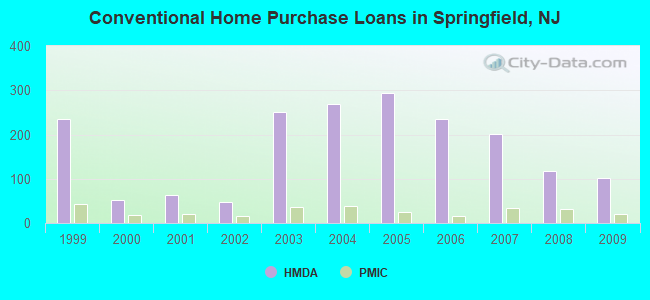
| Home Mortgage Disclosure Act Aggregated Statistics For Year 2009 (Based on 3 full tracts) | ||||||||||||
| A) FHA, FSA/RHS & VA Home Purchase Loans | B) Conventional Home Purchase Loans | C) Refinancings | D) Home Improvement Loans | E) Loans on Dwellings For 5+ Families | F) Non-occupant Loans on < 5 Family Dwellings (A B C & D) | |||||||
|---|---|---|---|---|---|---|---|---|---|---|---|---|
| Number | Average Value | Number | Average Value | Number | Average Value | Number | Average Value | Number | Average Value | Number | Average Value | |
| LOANS ORIGINATED | 47 | $315,766 | 101 | $293,000 | 404 | $281,413 | 19 | $150,105 | 1 | $980,000 | 4 | $189,000 |
| APPLICATIONS APPROVED, NOT ACCEPTED | 5 | $273,000 | 9 | $308,000 | 43 | $293,744 | 1 | $30,000 | 0 | $0 | 1 | $320,000 |
| APPLICATIONS DENIED | 12 | $340,250 | 9 | $348,333 | 147 | $309,626 | 11 | $86,455 | 0 | $0 | 5 | $284,400 |
| APPLICATIONS WITHDRAWN | 9 | $326,111 | 12 | $291,833 | 89 | $295,618 | 4 | $191,750 | 0 | $0 | 2 | $178,000 |
| FILES CLOSED FOR INCOMPLETENESS | 3 | $325,000 | 5 | $268,600 | 23 | $320,870 | 2 | $50,000 | 0 | $0 | 0 | $0 |
Detailed HMDA statistics for the following Tracts: 0375.00 , 0376.01, 0376.02
| Private Mortgage Insurance Companies Aggregated Statistics For Year 2009 (Based on 3 full tracts) | ||||
| A) Conventional Home Purchase Loans | B) Refinancings | |||
|---|---|---|---|---|
| Number | Average Value | Number | Average Value | |
| LOANS ORIGINATED | 20 | $328,450 | 6 | $363,833 |
| APPLICATIONS APPROVED, NOT ACCEPTED | 3 | $249,667 | 2 | $388,500 |
| APPLICATIONS DENIED | 2 | $376,000 | 3 | $311,333 |
| APPLICATIONS WITHDRAWN | 1 | $196,000 | 2 | $376,000 |
| FILES CLOSED FOR INCOMPLETENESS | 0 | $0 | 1 | $463,000 |
Detailed PMIC statistics for the following Tracts: 0375.00 , 0376.01, 0376.02

2003 - 2018 National Fire Incident Reporting System (NFIRS) incidents
- Fire incident types reported to NFIRS in Springfield, NJ
- 35539.6%Structure Fires
- 27230.3%Outside Fires
- 21924.4%Mobile Property/Vehicle Fires
- 515.7%Other
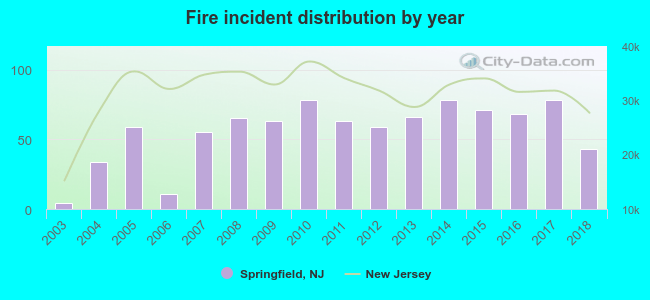 According to the data from the years 2003 - 2018 the average number of fire incidents per year is 56. The highest number of reported fire incidents - 78 took place in 2010, and the least - 4 in 2003. The data has a rising trend.
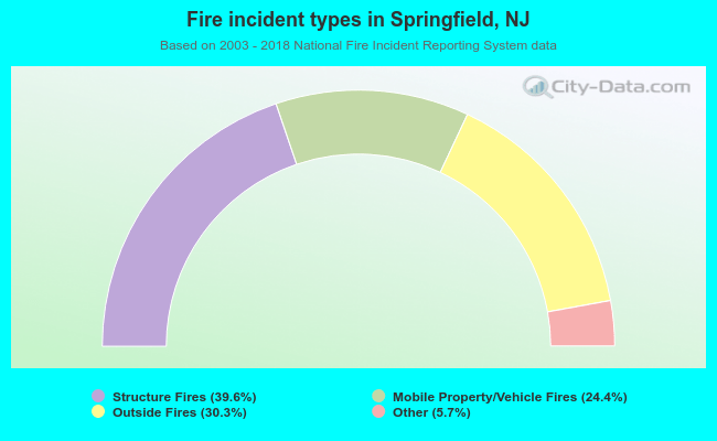 When looking into fire subcategories, the most reports belonged to: Structure Fires (39.6%), and Outside Fires (30.3%).
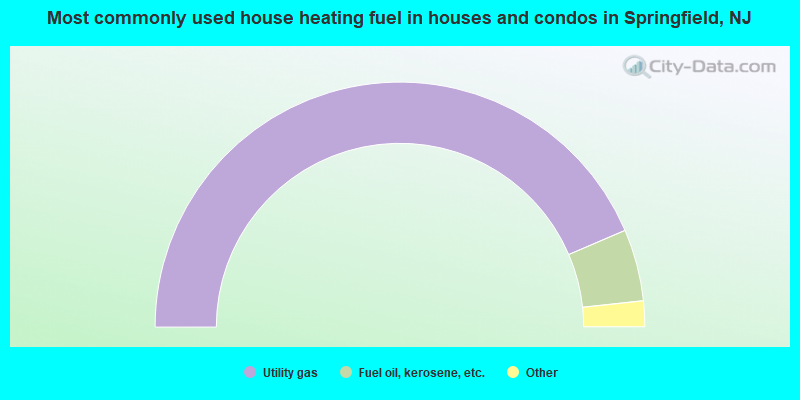
- 87.1%Utility gas
- 9.5%Fuel oil, kerosene, etc.
- 2.2%Electricity
- 0.7%Bottled, tank, or LP gas
- 0.2%Wood
- 0.2%Other fuel
- 0.2%No fuel used
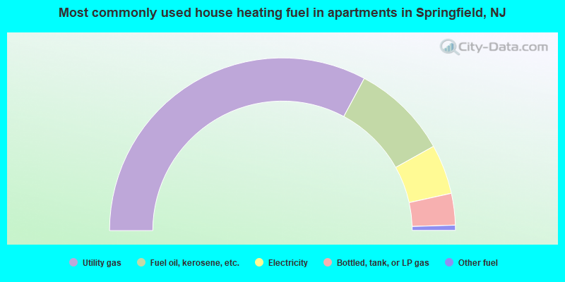
- 65.7%Utility gas
- 18.1%Fuel oil, kerosene, etc.
- 9.3%Electricity
- 5.9%Bottled, tank, or LP gas
- 1.0%Other fuel
Springfield compared to New Jersey state average:
- Median house value above state average.
- Unemployed percentage significantly below state average.
- Black race population percentage significantly below state average.
- Hispanic race population percentage significantly below state average.
- Renting percentage significantly below state average.
- Length of stay since moving in significantly above state average.
- Number of rooms per house significantly below state average.
- House age significantly below state average.
- Percentage of population with a bachelor's degree or higher above state average.
Springfield on our top lists:
- #6 on the list of "Top 101 cities with largest percentage of females in occupations: media and communication equipment workers (population 5,000+)"
- #7 on the list of "Top 101 cities with largest percentage of males in occupations: accountants and auditors (population 5,000+)"
- #19 on the list of "Top 101 cities with largest percentage of females in occupations: lawyers (population 5,000+)"
- #19 on the list of "Top 101 cities with largest percentage of females in industries: religious, grantmaking, civic, professional, and similar organizations (population 5,000+)"
- #23 on the list of "Top 101 cities with the lowest number of assaults per 100,000 residents (population 5,000+)"
- #28 on the list of "Top 101 cities with largest percentage of males in industries: petroleum and petroleum products merchant wholesalers (population 5,000+)"
- #30 on the list of "Top 101 cities with largest percentage of females in industries: chemicals (population 5,000+)"
- #30 on the list of "Top 101 cities with largest percentage of males in industries: personal and laundry services (population 5,000+)"
- #33 on the list of "Top 101 cities with largest percentage of females in occupations: religious workers (population 5,000+)"
- #34 on the list of "Top 101 cities with largest percentage of males in occupations: lawyers (population 5,000+)"
- #36 on the list of "Top 101 cities with largest percentage of females in occupations: accountants and auditors (population 5,000+)"
- #36 on the list of "Top 101 cities with largest percentage of males in industries: other direct selling establishments (population 5,000+)"
- #40 on the list of "Top 101 cities with largest percentage of males in industries: retail florists (population 5,000+)"
- #67 on the list of "Top 101 cities with largest percentage of females in industries: furniture and home furnishings, and household appliance stores (population 5,000+)"
- #68 on the list of "Top 101 cities with largest percentage of females in industries: clothing and accessories, including shoe, stores (population 5,000+)"
- #71 on the list of "Top 101 cities with largest percentage of males in industries: publishing, and motion picture and sound recording industries (population 5,000+)"
- #77 on the list of "Top 101 cities with largest percentage of females in industries: broadcasting and telecommunications (population 5,000+)"
- #84 on the list of "Top 101 cities with largest percentage of males in industries: data processing, libraries, and other information services (population 5,000+)"
- #90 on the list of "Top 101 cities with largest percentage of females in industries: data processing, libraries, and other information services (population 5,000+)"
- #58 (07081) on the list of "Top 101 zip codes with the largest percentage of Ukrainian first ancestries (pop 5,000+)"
- #76 (07081) on the list of "Top 101 zip codes with the largest percentage of Russian first ancestries (pop 5,000+)"
- #15 on the list of "Top 101 counties with the lowest percentage of residents that keep firearms around their homes"
- #17 on the list of "Top 101 counties with the largest decrease in the number of deaths per 1000 residents 2000-2006 to 2007-2013 (pop. 50,000+)"
- #47 on the list of "Top 101 counties with the most Orthodox adherents"
- #53 on the list of "Top 101 counties with the most Catholic adherents"
- #58 on the list of "Top 101 counties with the lowest percentage of residents that drank alcohol in the past 30 days"

|
|
Total of 333 patent applications in 2008-2024.