South Latimer, Oklahoma
Submit your own pictures of this place and show them to the world
- OSM Map
- General Map
- Google Map
- MSN Map

| Males: 1,394 | |
| Females: 1,234 |
| Median resident age: | 43.0 years |
| Oklahoma median age: | 35.5 years |
Zip code: 74578
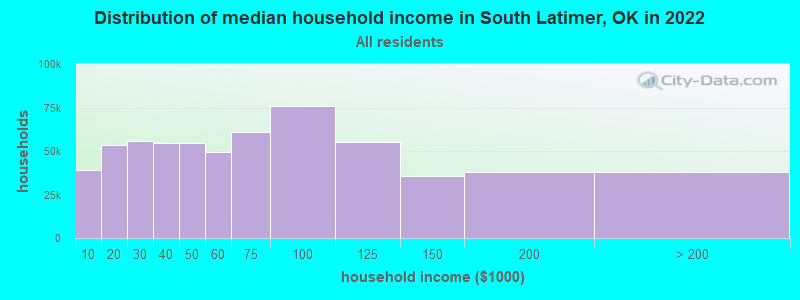
| South Latimer: | $44,898 |
| OK: | $59,673 |
Estimated per capita income in 2022: $25,514 (it was $13,284 in 2000)
South Latimer CCD income, earnings, and wages data
Estimated median house or condo value in 2022: $124,026 (it was $51,600 in 2000)
| South Latimer: | $124,026 |
| OK: | $191,700 |
Mean prices in 2022: all housing units: $136,068; detached houses: $162,703; mobile homes: $56,748; occupied boats, rvs, vans, etc.: $37,686
Detailed information about poverty and poor residents in South Latimer, OK
Compare current foreclosures near South Latimer, OK:
| Photo | Address | Area | Beds / Baths | Price | Details |
|---|---|---|---|---|---|

|
#1
S. 8th St.
Clayton, OK 74536
|
2,288 sq. feet
|
2 baths 4 beds |
$129,900
|
show details |

|
#2
SE 1141st Ave
Talihina, OK 74571
|
- sq. feet
|
- baths - beds |
show details | |

|
#3
SW 175th Rd
Wilburton, OK 74578
|
- sq. feet
|
- baths - beds |
show details | |

|
#4
Church St
Talihina, OK 74571
|
- sq. feet
|
- baths - beds |
show details | |

|
#5
6th St
Talihina, OK 74571
|
- sq. feet
|
- baths - beds |
show details | |

|
#6
Taylor St
Wilburton, OK 74578
|
- sq. feet
|
- baths - beds |
show details | |

|
Check over 1 million property listings on Foreclosure.com!
|
browse all offers | |||

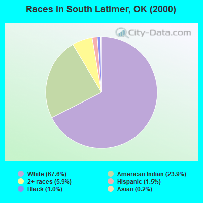
- 1,81267.6%White alone
- 64023.9%American Indian alone
- 1575.9%Two or more races
- 401.5%Hispanic
- 261.0%Black alone
- 50.2%Asian alone
- 10.04%Other race alone
Races in South Latimer detailed stats: ancestries, foreign born residents, place of birth
 Recent articles from our blog. Our writers, many of them Ph.D. graduates or candidates, create easy-to-read articles on a wide variety of topics.
Current Local Time: CST time zone
Land area: 293.3 square miles.
Population density: 9.0 people per square mile (very low).

| South Latimer CCD: | 0.4% ($205) |
| Oklahoma: | 0.8% ($523) |
Nearest city with pop. 50,000+: Fort Smith, AR  (65.6 miles , pop. 80,268).
Nearest city with pop. 200,000+: Tulsa, OK (103.4 miles , pop. 393,049).
Nearest city with pop. 1,000,000+: Dallas, TX (160.2 miles , pop. 1,188,580).
Nearest cities:
), ), Latitude: 34.74 N, Longitude: 95.27 W
Area code commonly used in this area: 918

| Here: | 5.1% |
| Oklahoma: | 3.2% |
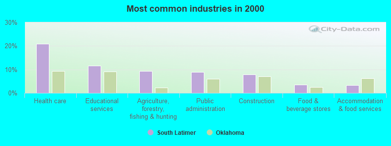
- Health care (21.0%)
- Educational services (11.6%)
- Agriculture, forestry, fishing & hunting (9.3%)
- Public administration (9.0%)
- Construction (7.8%)
- Food & beverage stores (3.6%)
- Accommodation & food services (3.3%)
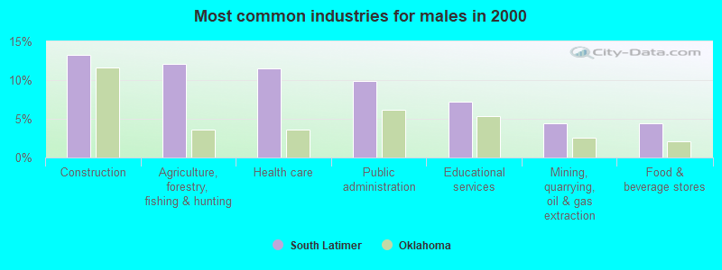
- Construction (13.2%)
- Agriculture, forestry, fishing & hunting (12.1%)
- Health care (11.6%)
- Public administration (9.9%)
- Educational services (7.2%)
- Mining, quarrying, oil & gas extraction (4.4%)
- Food & beverage stores (4.4%)
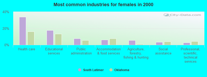
- Health care (33.7%)
- Educational services (17.6%)
- Public administration (7.7%)
- Accommodation & food services (6.2%)
- Agriculture, forestry, fishing & hunting (5.5%)
- Social assistance (3.5%)
- Professional, scientific, technical services (2.7%)
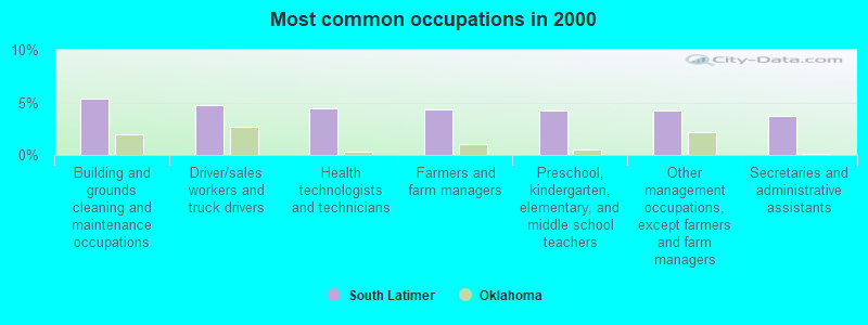
- Building and grounds cleaning and maintenance occupations (5.4%)
- Driver/sales workers and truck drivers (4.7%)
- Health technologists and technicians (4.4%)
- Farmers and farm managers (4.3%)
- Preschool, kindergarten, elementary, and middle school teachers (4.2%)
- Other management occupations, except farmers and farm managers (4.2%)
- Secretaries and administrative assistants (3.7%)
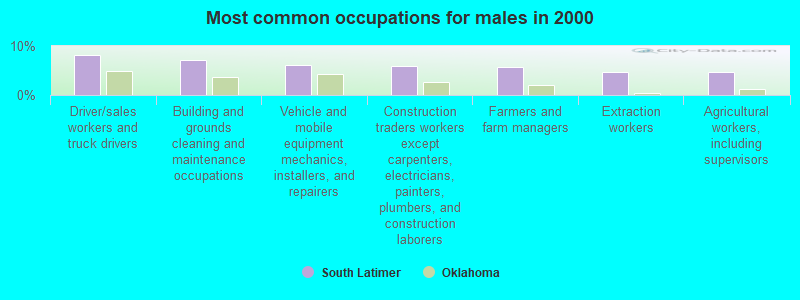
- Driver/sales workers and truck drivers (8.3%)
- Building and grounds cleaning and maintenance occupations (7.2%)
- Vehicle and mobile equipment mechanics, installers, and repairers (6.1%)
- Construction traders workers except carpenters, electricians, painters, plumbers, and construction laborers (5.9%)
- Farmers and farm managers (5.7%)
- Extraction workers (4.8%)
- Agricultural workers, including supervisors (4.8%)
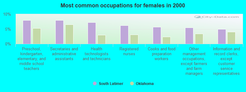
- Preschool, kindergarten, elementary, and middle school teachers (7.9%)
- Secretaries and administrative assistants (7.9%)
- Health technologists and technicians (7.2%)
- Registered nurses (6.2%)
- Cooks and food preparation workers (5.7%)
- Other management occupations, except farmers and farm managers (5.5%)
- Information and record clerks, except customer service representatives (5.0%)
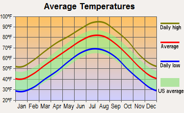
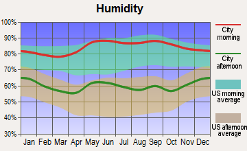
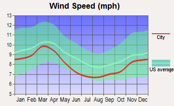
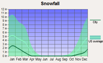
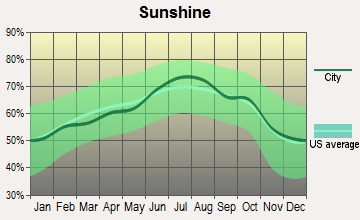
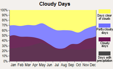
Average climate in South Latimer, Oklahoma
Based on data reported by over 4,000 weather stations

(lower is better)
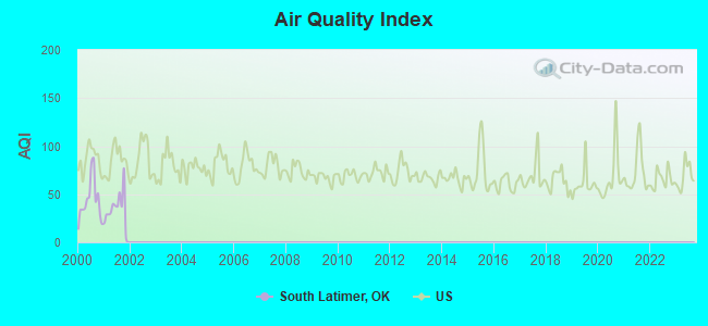
Air Quality Index (AQI) level in 2001 was 35.7. This is significantly better than average.
| City: | 35.7 |
| U.S.: | 72.6 |
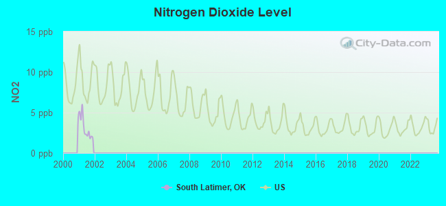
Nitrogen Dioxide (NO2) [ppb] level in 2001 was 3.10. This is significantly better than average. Closest monitor was 11.2 miles away from the city center.
| City: | 3.10 |
| U.S.: | 5.11 |
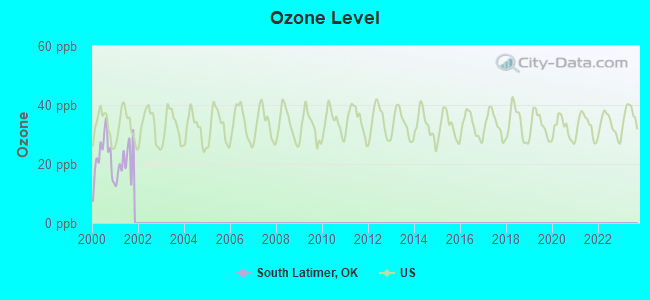
Ozone [ppb] level in 2001 was 20.8. This is significantly better than average. Closest monitor was 5.2 miles away from the city center.
| City: | 20.8 |
| U.S.: | 33.3 |
Tornado activity:
South Latimer-area historical tornado activity is slightly below Oklahoma state average. It is 88% greater than the overall U.S. average.
On 5/5/1960, a category F4 (max. wind speeds 207-260 mph) tornado 9.9 miles away from the South Latimer place center killed 16 people and injured 106 people and caused between $500,000 and $5,000,000 in damages.
On 3/26/1976, a category F4 tornado 10.7 miles away from the place center killed one person and injured 4 people and caused between $50,000 and $500,000 in damages.
Earthquake activity:
South Latimer-area historical earthquake activity is significantly above Oklahoma state average. It is 640% greater than the overall U.S. average.On 11/6/2011 at 03:53:10, a magnitude 5.7 (5.7 MW, Depth: 3.2 mi, Class: Moderate, Intensity: VI - VII) earthquake occurred 101.0 miles away from the city center
On 9/3/2016 at 12:02:44, a magnitude 5.8 (5.8 MW, Depth: 3.5 mi) earthquake occurred 149.5 miles away from the city center
On 11/7/2016 at 01:44:24, a magnitude 5.0 (5.0 MW, Depth: 2.8 mi) earthquake occurred 122.5 miles away from the city center
On 11/5/2011 at 07:12:45, a magnitude 4.8 (4.8 MW, Depth: 1.9 mi, Class: Light, Intensity: IV - V) earthquake occurred 101.6 miles away from South Latimer center
On 11/8/2011 at 02:46:57, a magnitude 4.8 (4.8 MW, Depth: 3.1 mi) earthquake occurred 102.0 miles away from the city center
On 9/6/1997 at 23:38:00, a magnitude 4.5 (4.5 LG, 4.2 LG, Depth: 3.1 mi) earthquake occurred 66.7 miles away from South Latimer center
Magnitude types: regional Lg-wave magnitude (LG), moment magnitude (MW)
Natural disasters:
The number of natural disasters in Latimer County (26) is a lot greater than the US average (15).Major Disasters (Presidential) Declared: 19
Emergencies Declared: 6
Causes of natural disasters: Storms: 15, Floods: 14, Tornadoes: 12, Winter Storms: 7, Heavy Rains: 2, Hurricane: 1, Snow: 1, Wind: 1, Other: 1 (Note: some incidents may be assigned to more than one category).
Hospitals and medical centers near South Latimer:
- LATIMER COUNTY HOME HEALTH CARE AGENCY (Home Health Center, about 13 miles away; WILBURTON, OK)
- 3 D HEALTH CARE, INC (Home Health Center, about 13 miles away; WILBURTON, OK)
- GOLDEN YEARS CARE CENTER (Nursing Home, about 13 miles away; WILBURTON, OK)
- COMMUNITY CARE CENTER, INC. (Nursing Home, about 13 miles away; WILBURTON, OK)
- LATIMER COUNTY GENERAL HOSPITAL Acute Care Hospitals (about 13 miles away; WILBURTON, OK)
- LATIMER NURSING HOME (Nursing Home, about 13 miles away; WILBURTON, OK)
Colleges/universities with over 2000 students nearest to South Latimer:
- Carl Albert State College (about 42 miles; Poteau, OK; Full-time enrollment: 2,041)
- University of Arkansas-Fort Smith (about 68 miles; Fort Smith, AR; FT enrollment: 6,103)
- Oklahoma State University Institute of Technology (about 73 miles; Okmulgee, OK; FT enrollment: 3,243)
- Paris Junior College (about 77 miles; Paris, TX; FT enrollment: 3,875)
- East Central University (about 80 miles; Ada, OK; FT enrollment: 4,030)
- Southeastern Oklahoma State University (about 82 miles; Durant, OK; FT enrollment: 3,365)
- Northeastern State University (about 84 miles; Tahlequah, OK; FT enrollment: 6,895)
Points of interest:
Notable locations in South Latimer: Evangelistic Tabernacle (A), Waterworks Picnic Area (B), Kiamichi Camp (C), Oklahoma Forestry Services Talihina Field Office (D), Higgins Fire Department (E), State Veterans Center (F), United States War Veteran Colony Volunteer Fire Department (G). Display/hide their locations on the map
Churches in South Latimer include: Cravens Church (A), Cupco Church (B), Falfa Church (C), Pine Grove Church (D). Display/hide their locations on the map
Cemeteries: Baldwin Cemetery (1), Veterans Memorial Park (2), Cupco Cemetery (3), Hokit Cemetery (4), King Cemetery (5), Laura Cemetery (6), Peachland Cemetery (7). Display/hide their locations on the map
Reservoirs: Lake Carl Albert (A), Talihina Lake (B), Fourche Maline Creek Site 14 Reservoir (C), Fourche Maline Creek Site 13 Reservoir (D), Fourche Maline Creek Site 8 Reservoir (E), Lake Talihina (F), Oknoname 077002 Reservoir (G), Oknoname 077006 Reservoir (H). Display/hide their locations on the map
Streams, rivers, and creeks: Buffalo Creek (A), West Fork Anderson Creek (B), Bridge Set Creek (C), Boggs Hollow Creek (D), Coopers Branch (E), South Peachland Creek (F), South Long Creek (G), Cedar Creek (H), Rock Creek (I). Display/hide their locations on the map
| This place: | 2.5 people |
| Oklahoma: | 2.5 people |
| This place: | 69.9% |
| Whole state: | 66.8% |
| This place: | 4.9% |
| Whole state: | 5.9% |
Likely homosexual households (counted as self-reported same-sex unmarried-partner households)
- Lesbian couples: 0.4% of all households
- Gay men: 0.5% of all households
| This place: | 18.3% |
| Whole state: | 14.7% |
| This place: | 7.9% |
| Whole state: | 6.1% |
People in group quarters in South Latimer in 2010:
- 172 people in nursing facilities/skilled-nursing facilities
- 27 people in residential treatment centers for adults
- 20 people in in-patient hospice facilities
7 people in other group homes in 2000
For population 15 years and over in South Latimer:
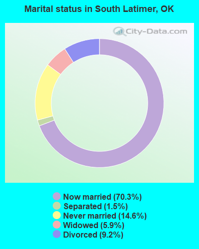
- Never married: 14.6%
- Now married: 70.3%
- Separated: 1.5%
- Widowed: 5.9%
- Divorced: 9.2%
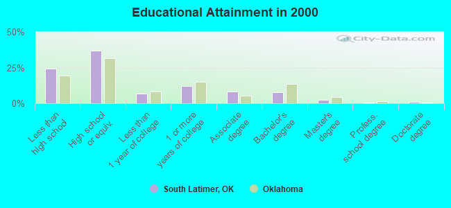
For population 25 years and over in South Latimer:
- High school or higher: 75.7%
- Bachelor's degree or higher: 11.6%
- Graduate or professional degree: 4.0%
- Unemployed: 8.3%
- Mean travel time to work (commute): 23.0 minutes
| Here: | 12.4 |
| Oklahoma average: | 11.7 |
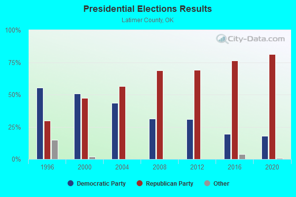
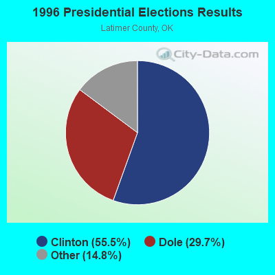
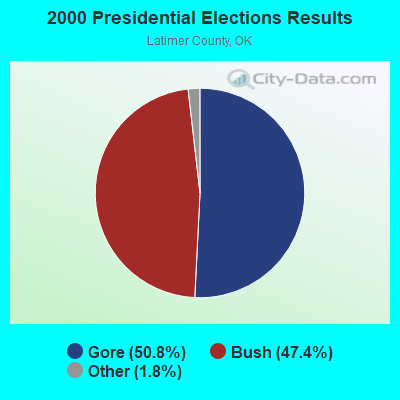
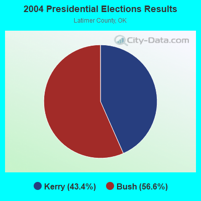

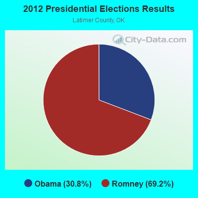
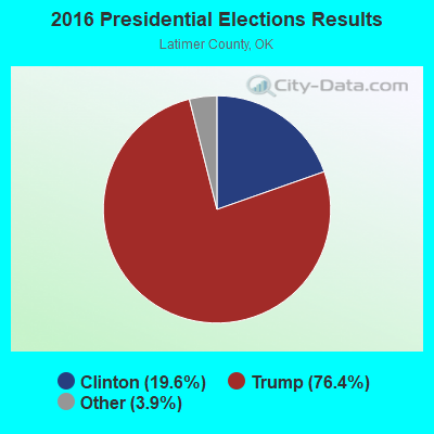
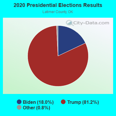
Graphs represent county-level data. Detailed 2008 Election Results
Religion statistics for South Latimer, OK (based on Latimer County data)
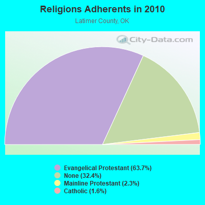
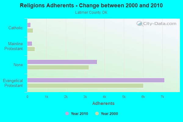
| Religion | Adherents | Congregations |
|---|---|---|
| Evangelical Protestant | 7,110 | 37 |
| Mainline Protestant | 254 | 3 |
| Catholic | 180 | 1 |
| Other | - | 1 |
| None | 3,610 | - |
Food Environment Statistics:
| Latimer County: | 1.92 / 10,000 pop. |
| State: | 1.97 / 10,000 pop. |
| This county: | 1.92 / 10,000 pop. |
| State: | 4.35 / 10,000 pop. |
| Latimer County: | 2.88 / 10,000 pop. |
| Oklahoma: | 6.89 / 10,000 pop. |
| Latimer County: | 11.8% |
| Oklahoma: | 10.3% |
| Latimer County: | 31.8% |
| Oklahoma: | 29.2% |
Strongest AM radio stations in South Latimer:
- KRMG (740 AM; 50 kW; TULSA, OK; Owner: CXR HOLDINGS, INC.)
- KFAQ (1170 AM; 50 kW; TULSA, OK; Owner: JOURNAL BROADCAST CORPORATION)
- KEEL (710 AM; 50 kW; SHREVEPORT, LA; Owner: CITICASTERS LICENSES, L.P.)
- KFXR (1190 AM; 50 kW; DALLAS, TX; Owner: CLEAR CHANNEL BROADCASTING LICENSES, INC.)
- KRLD (1080 AM; 50 kW; DALLAS, TX; Owner: TEXAS INFINITY BROADCASTING L.P.)
- KGHT (880 AM; 50 kW; SHERIDAN, AR; Owner: METROPOLITAN RADIO GROUP, INC.)
- KOMA (1520 AM; 50 kW; OKLAHOMA CITY, OK; Owner: RENDA BROADCASTING CORP. OF NEVADA)
- WBAP (820 AM; 50 kW; FORT WORTH, TX; Owner: WBAP-KSCS OPERATING, LTD.)
- KWKH (1130 AM; 50 kW; SHREVEPORT, LA; Owner: CITICASTERS LICENSES, L.P.)
- KYHN (1320 AM; 10 kW; FORT SMITH, AR; Owner: CAPSTAR TX LIMITED PARTNERSHIP)
- KAAY (1090 AM; 50 kW; LITTLE ROCK, AR; Owner: CITADEL BROADCASTING COMPANY)
- KTBZ (1430 AM; 25 kW; TULSA, OK; Owner: CLEAR CHANNEL BROADCASTING LICENSES, INC.)
- KEOR (1110 AM; daytime; 5 kW; ATOKA, OK; Owner: DALLAS AM RADIO PARTNERS, L.P.)
Strongest FM radio stations in South Latimer:
- KTKL (88.5 FM; STIGLER, OK; Owner: EDUCATIONAL MEDIA FOUNDATION)
- KZBB (97.9 FM; POTEAU, OK; Owner: CAPSTAR TX LIMITED PARTNERSHIP)
- KMAG (99.1 FM; FORT SMITH, AR; Owner: CAPSTAR TX LIMITED PARTNERSHIP)
- KTCS-FM (99.9 FM; FORT SMITH, AR; Owner: BIG CHIEF BROADCASTING COMPANY)
- K204EW (88.7 FM; POTEAU, OK; Owner: CALVARY CHAPEL OF TWIN FALLS, INC.)
- K219CN (91.7 FM; POTEAU, OK; Owner: AMERICAN FAMILY ASSOCIATION)
- KARG (91.7 FM; POTEAU, OK; Owner: AMERICAN FAMILY ASSOCIATION)
- KMMY (97.1 FM; MUSKOGEE, OK; Owner: KMMY, Inc.)
- KOMS (107.3 FM; POTEAU, OK; Owner: CUMULUS LICENSING CORP.)
- KMCO (101.3 FM; MCALESTER, OK; Owner: LITTLE DIXIE RADIO, INC.)
- KESC (103.7 FM; WILBURTON, OK; Owner: LITTLE DIXIE RADIO, INC)
TV broadcast stations around South Latimer:
- KOET (Channel 3; EUFAULA, OK; Owner: OKLAHOMA EDUCATIONAL TELEVISION AUTHORITY)
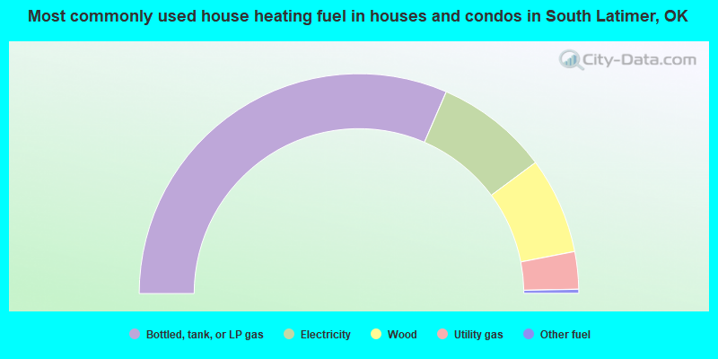
- 63.0%Bottled, tank, or LP gas
- 16.7%Electricity
- 14.2%Wood
- 5.5%Utility gas
- 0.6%Other fuel
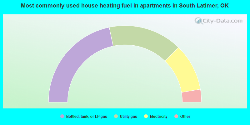
- 43.4%Bottled, tank, or LP gas
- 31.2%Utility gas
- 20.0%Electricity
- 2.9%Fuel oil, kerosene, etc.
- 2.4%Wood
South Latimer compared to Oklahoma state average:
- Median house value below state average.
- Unemployed percentage below state average.
- Black race population percentage significantly below state average.
- Hispanic race population percentage significantly below state average.
- Median age above state average.
- Foreign-born population percentage significantly below state average.
- Renting percentage below state average.
- Length of stay since moving in significantly above state average.
- Number of rooms per house significantly below state average.
- House age significantly below state average.
- Institutionalized population percentage above state average.
- Percentage of population with a bachelor's degree or higher below state average.