North Pushmataha, Oklahoma
Submit your own pictures of this place and show them to the world
- OSM Map
- General Map
- Google Map
- MSN Map

| Males: 1,522 | |
| Females: 1,625 |
| Median resident age: | 40.2 years |
| Oklahoma median age: | 35.5 years |
Zip code: 74536
| North Pushmataha: | $38,993 |
| OK: | $59,673 |
Estimated per capita income in 2022: $21,277 (it was $11,949 in 2000)
North Pushmataha CCD income, earnings, and wages data
Estimated median house or condo value in 2022: $99,187 (it was $38,100 in 2000)
| North Pushmataha: | $99,187 |
| OK: | $191,700 |
Mean prices in 2022: all housing units: $166,254; detached houses: $182,254; mobile homes: $99,843; occupied boats, rvs, vans, etc.: $31,035
North Pushmataha, OK residents, houses, and apartments details
Detailed information about poverty and poor residents in North Pushmataha, OK
Compare current foreclosures near North Pushmataha, OK:
| Photo | Address | Area | Beds / Baths | Price | Details |
|---|---|---|---|---|---|

|
#1
S. 8th St.
Clayton, OK 74536
|
2,288 sq. feet
|
2 baths 4 beds |
$129,900
|
show details |

|
#2
SE 1141st Ave
Talihina, OK 74571
|
- sq. feet
|
- baths - beds |
show details | |

|
#3
Church St
Talihina, OK 74571
|
- sq. feet
|
- baths - beds |
show details | |

|
#4
6th St
Talihina, OK 74571
|
- sq. feet
|
- baths - beds |
show details | |

|
Check over 1 million property listings on Foreclosure.com!
|
browse all offers | |||

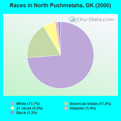
- 2,32573.7%White alone
- 56117.8%American Indian alone
- 1875.9%Two or more races
- 451.4%Hispanic
- 371.2%Black alone
- 10.03%Asian alone
Races in North Pushmataha detailed stats: ancestries, foreign born residents, place of birth
 Recent articles from our blog. Our writers, many of them Ph.D. graduates or candidates, create easy-to-read articles on a wide variety of topics.
Current Local Time: CST time zone
Land area: 464.3 square miles.
Population density: 6.8 people per square mile (very low).

| North Pushmataha CCD: | 0.5% ($199) |
| Oklahoma: | 0.8% ($523) |
Nearest city with pop. 50,000+: Fort Smith, AR  (72.2 miles , pop. 80,268).
Nearest city with pop. 200,000+: Tulsa, OK (113.9 miles , pop. 393,049).
Nearest city with pop. 1,000,000+: Dallas, TX (152.3 miles , pop. 1,188,580).
Nearest cities:
), ), ), Latitude: 34.59 N, Longitude: 95.24 W
Area code commonly used in this area: 918

| Here: | 4.1% |
| Oklahoma: | 3.2% |
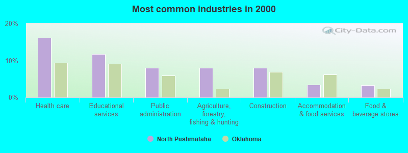
- Health care (16.2%)
- Educational services (11.8%)
- Public administration (8.0%)
- Agriculture, forestry, fishing & hunting (8.0%)
- Construction (8.0%)
- Accommodation & food services (3.5%)
- Food & beverage stores (3.4%)
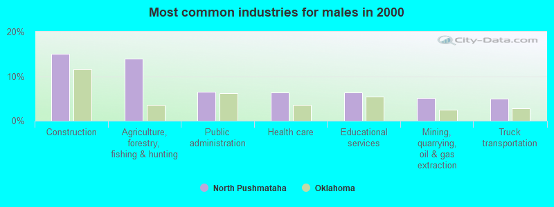
- Construction (15.0%)
- Agriculture, forestry, fishing & hunting (14.0%)
- Public administration (6.5%)
- Health care (6.4%)
- Educational services (6.4%)
- Mining, quarrying, oil & gas extraction (5.1%)
- Truck transportation (4.9%)
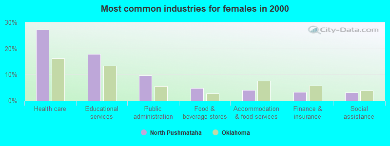
- Health care (27.2%)
- Educational services (17.9%)
- Public administration (9.7%)
- Food & beverage stores (4.8%)
- Accommodation & food services (4.2%)
- Finance & insurance (3.4%)
- Social assistance (3.2%)
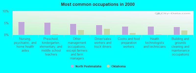
- Nursing, psychiatric, and home health aides (5.5%)
- Preschool, kindergarten, elementary, and middle school teachers (5.2%)
- Other management occupations, except farmers and farm managers (4.8%)
- Driver/sales workers and truck drivers (4.2%)
- Cooks and food preparation workers (3.6%)
- Health technologists and technicians (3.6%)
- Building and grounds cleaning and maintenance occupations (3.4%)

- Driver/sales workers and truck drivers (7.1%)
- Fishing, hunting, and forestry occupations (5.7%)
- Vehicle and mobile equipment mechanics, installers, and repairers (4.6%)
- Other management occupations, except farmers and farm managers (4.4%)
- Construction laborers (3.9%)
- Other production occupations, including supervisors (3.7%)
- Agricultural workers, including supervisors (3.5%)
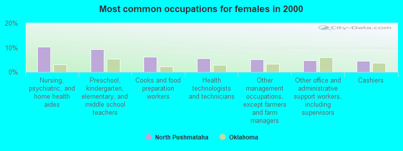
- Nursing, psychiatric, and home health aides (10.3%)
- Preschool, kindergarten, elementary, and middle school teachers (9.3%)
- Cooks and food preparation workers (6.2%)
- Health technologists and technicians (5.6%)
- Other management occupations, except farmers and farm managers (5.2%)
- Other office and administrative support workers, including supervisors (4.8%)
- Cashiers (4.6%)
Average climate in North Pushmataha, Oklahoma
Based on data reported by over 4,000 weather stations


(lower is better)
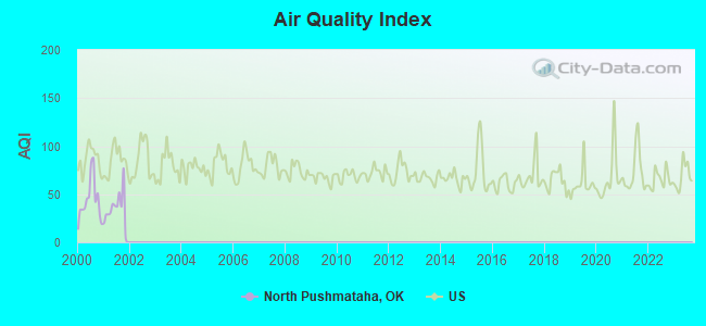
Air Quality Index (AQI) level in 2001 was 35.7. This is significantly better than average.
| City: | 35.7 |
| U.S.: | 72.6 |
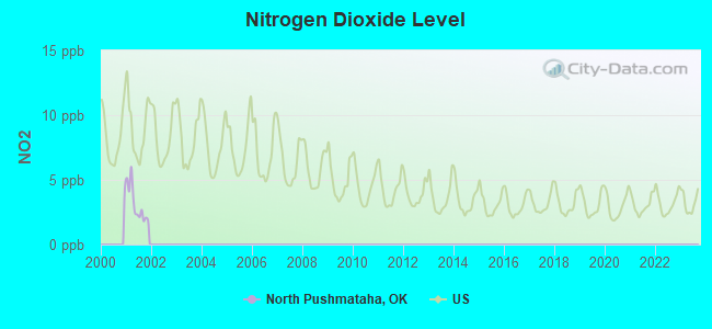
Nitrogen Dioxide (NO2) [ppb] level in 2001 was 3.10. This is significantly better than average. Closest monitor was 12.9 miles away from the city center.
| City: | 3.10 |
| U.S.: | 5.11 |
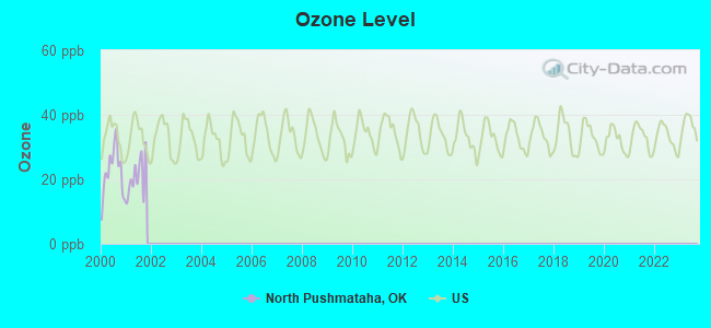
Ozone [ppb] level in 2001 was 20.8. This is significantly better than average. Closest monitor was 12.0 miles away from the city center.
| City: | 20.8 |
| U.S.: | 33.3 |
Tornado activity:
North Pushmataha-area historical tornado activity is slightly below Oklahoma state average. It is 82% greater than the overall U.S. average.
On 5/5/1961, a category F4 (max. wind speeds 207-260 mph) tornado 15.6 miles away from the North Pushmataha place center killed 16 people and injured 58 people and caused between $50,000 and $500,000 in damages.
On 3/26/1976, a category F4 tornado 15.7 miles away from the place center killed one person and injured 4 people and caused between $50,000 and $500,000 in damages.
Earthquake activity:
North Pushmataha-area historical earthquake activity is significantly above Oklahoma state average. It is 624% greater than the overall U.S. average.On 11/6/2011 at 03:53:10, a magnitude 5.7 (5.7 MW, Depth: 3.2 mi, Class: Moderate, Intensity: VI - VII) earthquake occurred 108.3 miles away from the city center
On 9/3/2016 at 12:02:44, a magnitude 5.8 (5.8 MW, Depth: 3.5 mi) earthquake occurred 158.8 miles away from the city center
On 11/7/2016 at 01:44:24, a magnitude 5.0 (5.0 MW, Depth: 2.8 mi) earthquake occurred 131.2 miles away from the city center
On 11/5/2011 at 07:12:45, a magnitude 4.8 (4.8 MW, Depth: 1.9 mi, Class: Light, Intensity: IV - V) earthquake occurred 109.0 miles away from North Pushmataha center
On 11/8/2011 at 02:46:57, a magnitude 4.8 (4.8 MW, Depth: 3.1 mi) earthquake occurred 109.3 miles away from North Pushmataha center
On 9/6/1997 at 23:38:00, a magnitude 4.5 (4.5 LG, 4.2 LG, Depth: 3.1 mi) earthquake occurred 68.1 miles away from North Pushmataha center
Magnitude types: regional Lg-wave magnitude (LG), moment magnitude (MW)
Natural disasters:
The number of natural disasters in Pushmataha County (23) is greater than the US average (15).Major Disasters (Presidential) Declared: 15
Emergencies Declared: 6
Causes of natural disasters: Storms: 12, Floods: 11, Tornadoes: 9, Winter Storms: 8, Winds: 3, Heavy Rain: 1, Hurricane: 1, Snow: 1, Other: 1 (Note: some incidents may be assigned to more than one category).
Colleges/universities with over 2000 students nearest to North Pushmataha:
- Carl Albert State College (about 47 miles; Poteau, OK; Full-time enrollment: 2,041)
- Paris Junior College (about 67 miles; Paris, TX; FT enrollment: 3,875)
- University of Arkansas-Fort Smith (about 74 miles; Fort Smith, AR; FT enrollment: 6,103)
- Southeastern Oklahoma State University (about 77 miles; Durant, OK; FT enrollment: 3,365)
- East Central University (about 82 miles; Ada, OK; FT enrollment: 4,030)
- Oklahoma State University Institute of Technology (about 83 miles; Okmulgee, OK; FT enrollment: 3,243)
- Northeastern State University (about 94 miles; Tahlequah, OK; FT enrollment: 6,895)
Points of interest:
Notable locations in North Pushmataha: Old Choctaw Indian Council House (A), Trails End Camp (B), Kiamichi Fish Farm (C), Nashoba Fire Department (D), Albion Fire Department (E), Clayton Fire Department (F), Buffalo Valley Volunteer Fire Department (G), Honobia Volunteer Fire Department (H). Display/hide their locations on the map
Churches in North Pushmataha include: Buffalo Church (A), Friendship Church (B), Head Church (C), Mission Church (D). Display/hide their locations on the map
Cemeteries: Albion Cemetery (1), Anderson Cemetery (2), Armstrong Cemetery (3), Fewell Cemetery (4), Heath Cemetery (5), Black Fork Cemetery (6), Bond Cemetery (7). Display/hide their locations on the map
Reservoirs: Nanih Waiya Lake (A), Oknoname 127005 Reservoir (B), Lake Nanih Waiya (C), Clayton Lake (D), Sardis Lake (E). Display/hide their locations on the map
Streams, rivers, and creeks: Wildhorse Creek (A), Wildcat Creek (B), Bull Creek (C), Davis Branch (D), Holly Creek (E), Buffalo Creek (F), Bryant Branch (G), Brushy Creek (H), Crumb Creek (I). Display/hide their locations on the map
| This place: | 2.3 people |
| Oklahoma: | 2.5 people |
| This place: | 65.7% |
| Whole state: | 66.8% |
| This place: | 6.5% |
| Whole state: | 5.9% |
Likely homosexual households (counted as self-reported same-sex unmarried-partner households)
- Lesbian couples: 0.2% of all households
- Gay men: 0.3% of all households
| This place: | 26.6% |
| Whole state: | 14.7% |
| This place: | 9.1% |
| Whole state: | 6.1% |
For population 15 years and over in North Pushmataha:
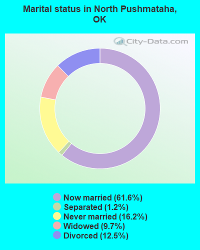
- Never married: 16.2%
- Now married: 61.6%
- Separated: 1.2%
- Widowed: 9.7%
- Divorced: 12.5%
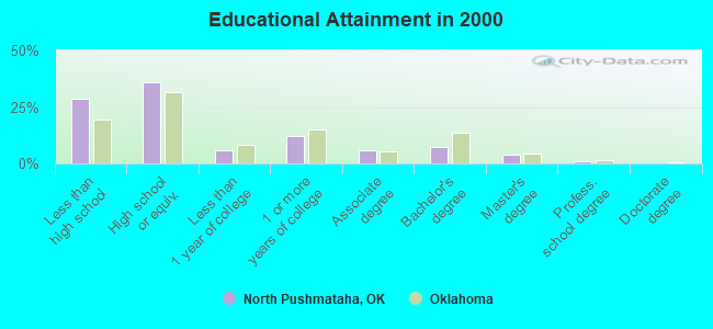
For population 25 years and over in North Pushmataha:
- High school or higher: 71.5%
- Bachelor's degree or higher: 12.3%
- Graduate or professional degree: 5.2%
- Unemployed: 9.2%
- Mean travel time to work (commute): 31.7 minutes
| Here: | 13.1 |
| Oklahoma average: | 11.7 |
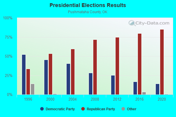
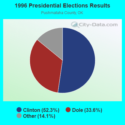
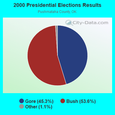
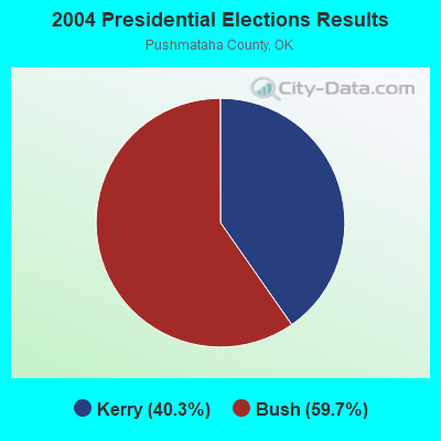
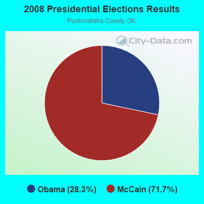
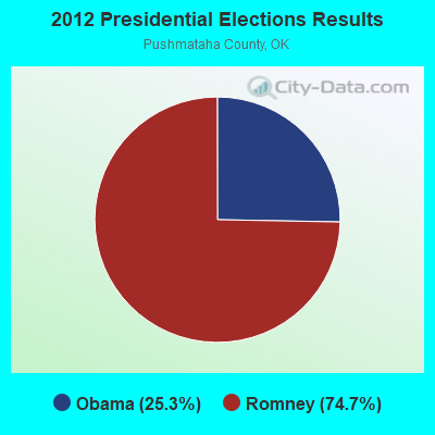
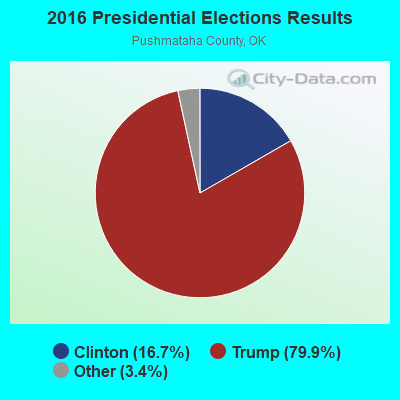
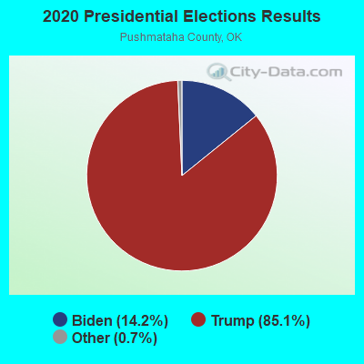
Graphs represent county-level data. Detailed 2008 Election Results
Religion statistics for North Pushmataha, OK (based on Pushmataha County data)
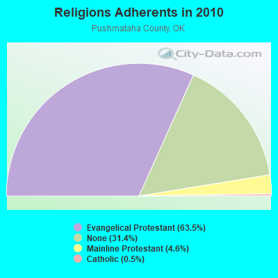
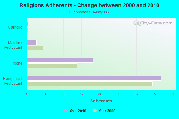
| Religion | Adherents | Congregations |
|---|---|---|
| Evangelical Protestant | 7,344 | 41 |
| Mainline Protestant | 536 | 8 |
| Catholic | 60 | 1 |
| Other | - | 2 |
| None | 3,632 | - |
Food Environment Statistics:
| Pushmataha County: | 4.30 / 10,000 pop. |
| Oklahoma: | 1.97 / 10,000 pop. |
| Here: | 0.86 / 10,000 pop. |
| Oklahoma: | 0.76 / 10,000 pop. |
| Here: | 9.45 / 10,000 pop. |
| State: | 4.35 / 10,000 pop. |
| This county: | 2.58 / 10,000 pop. |
| Oklahoma: | 6.89 / 10,000 pop. |
| This county: | 12.6% |
| Oklahoma: | 10.3% |
| Pushmataha County: | 30.2% |
| Oklahoma: | 29.2% |
Strongest AM radio stations in North Pushmataha:
- KRMG (740 AM; 50 kW; TULSA, OK; Owner: CXR HOLDINGS, INC.)
- KFAQ (1170 AM; 50 kW; TULSA, OK; Owner: JOURNAL BROADCAST CORPORATION)
- KEEL (710 AM; 50 kW; SHREVEPORT, LA; Owner: CITICASTERS LICENSES, L.P.)
- KFXR (1190 AM; 50 kW; DALLAS, TX; Owner: CLEAR CHANNEL BROADCASTING LICENSES, INC.)
- KRLD (1080 AM; 50 kW; DALLAS, TX; Owner: TEXAS INFINITY BROADCASTING L.P.)
- KGHT (880 AM; 50 kW; SHERIDAN, AR; Owner: METROPOLITAN RADIO GROUP, INC.)
- KWKH (1130 AM; 50 kW; SHREVEPORT, LA; Owner: CITICASTERS LICENSES, L.P.)
- WBAP (820 AM; 50 kW; FORT WORTH, TX; Owner: WBAP-KSCS OPERATING, LTD.)
- KOMA (1520 AM; 50 kW; OKLAHOMA CITY, OK; Owner: RENDA BROADCASTING CORP. OF NEVADA)
- KAAY (1090 AM; 50 kW; LITTLE ROCK, AR; Owner: CITADEL BROADCASTING COMPANY)
- KEOR (1110 AM; daytime; 5 kW; ATOKA, OK; Owner: DALLAS AM RADIO PARTNERS, L.P.)
- KESS (1270 AM; 50 kW; FORT WORTH, TX; Owner: KESS-AM LICENSE CORP.)
- KYHN (1320 AM; 10 kW; FORT SMITH, AR; Owner: CAPSTAR TX LIMITED PARTNERSHIP)
Strongest FM radio stations in North Pushmataha:
- KZBB (97.9 FM; POTEAU, OK; Owner: CAPSTAR TX LIMITED PARTNERSHIP)
- KMAG (99.1 FM; FORT SMITH, AR; Owner: CAPSTAR TX LIMITED PARTNERSHIP)
- KTCS-FM (99.9 FM; FORT SMITH, AR; Owner: BIG CHIEF BROADCASTING COMPANY)
- K204EW (88.7 FM; POTEAU, OK; Owner: CALVARY CHAPEL OF TWIN FALLS, INC.)
- K219CN (91.7 FM; POTEAU, OK; Owner: AMERICAN FAMILY ASSOCIATION)
- KARG (91.7 FM; POTEAU, OK; Owner: AMERICAN FAMILY ASSOCIATION)
- KTKL (88.5 FM; STIGLER, OK; Owner: EDUCATIONAL MEDIA FOUNDATION)
- KOMS (107.3 FM; POTEAU, OK; Owner: CUMULUS LICENSING CORP.)
- KMMY (97.1 FM; MUSKOGEE, OK; Owner: KMMY, Inc.)
- KKBI (106.1 FM; BROKEN BOW, OK; Owner: J.D.C. RADIO, INC.)
- National Bridge Inventory (NBI) Statistics
- 5Number of bridges
- 33ft / 9.8mTotal length
- $3,964,000Total costs
- 5,190Total average daily traffic
- 800Total average daily truck traffic
- 8,304Total future (year 2040) average daily traffic
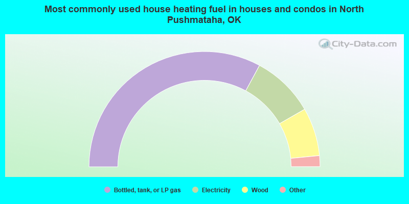
- 65.8%Bottled, tank, or LP gas
- 17.6%Electricity
- 13.5%Wood
- 1.7%Utility gas
- 0.7%Other fuel
- 0.5%Fuel oil, kerosene, etc.
- 0.2%No fuel used
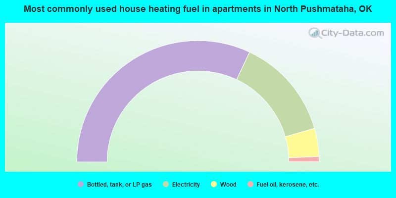
- 64.0%Bottled, tank, or LP gas
- 27.1%Electricity
- 7.5%Wood
- 1.4%Fuel oil, kerosene, etc.
North Pushmataha compared to Oklahoma state average:
- Median household income below state average.
- Median house value below state average.
- Black race population percentage significantly below state average.
- Hispanic race population percentage significantly below state average.
- Foreign-born population percentage significantly below state average.
- Length of stay since moving in significantly above state average.
- Number of rooms per house significantly below state average.
- House age significantly below state average.
- Number of college students below state average.
- Percentage of population with a bachelor's degree or higher below state average.