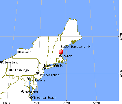
South Hampton, New Hampshire
Submit your own pictures of this town and show them to the world
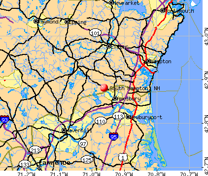
- OSM Map
- General Map
- Google Map
- MSN Map
Population change since 2000: -3.6%
 |
| Males: 395 | |
| Females: 419 |
| Median resident age: | 47.2 years |
| New Hampshire median age: | 43.9 years |
Zip codes: 03827.
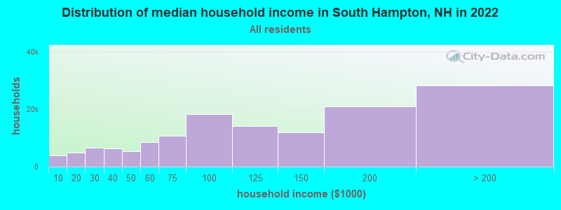
| South Hampton: | $117,789 |
| NH: | $89,992 |
Estimated per capita income in 2022: $62,093 (it was $28,287 in 2000)
South Hampton town income, earnings, and wages data
Estimated median house or condo value in 2022: $701,564 (it was $229,600 in 2000)
| South Hampton: | $701,564 |
| NH: | $384,700 |
Mean prices in 2022: all housing units: $614,227; detached houses: $665,470; townhouses or other attached units: $408,866; in 2-unit structures: $730,084; in 3-to-4-unit structures: over $1,000,000; in 5-or-more-unit structures: $329,099; mobile homes: $126,160
Detailed information about poverty and poor residents in South Hampton, NH


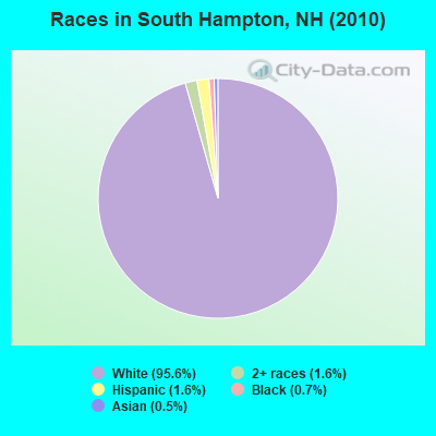
- 77895.6%White alone
- 131.6%Two or more races
- 131.6%Hispanic
- 60.7%Black alone
- 40.5%Asian alone
Races in South Hampton detailed stats: ancestries, foreign born residents, place of birth
According to our research of New Hampshire and other state lists, there was 1 registered sex offender living in South Hampton, New Hampshire as of May 17, 2024.
The ratio of all residents to sex offenders in South Hampton is 814 to 1.
The ratio of registered sex offenders to all residents in this city is lower than the state average.
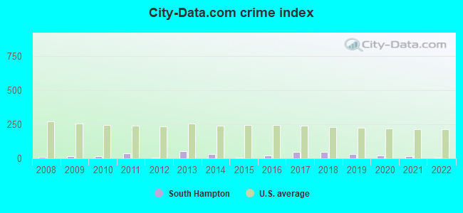
Type |
2009 |
2010 |
2011 |
2012 |
2013 |
2014 |
2015 |
2016 |
2017 |
2018 |
2019 |
2020 |
2021 |
2022 |
|---|---|---|---|---|---|---|---|---|---|---|---|---|---|---|
| Murders (per 100,000) | 0 (0.0) | 0 (0.0) | 0 (0.0) | 0 (0.0) | 0 (0.0) | 0 (0.0) | 0 (0.0) | 0 (0.0) | 0 (0.0) | 0 (0.0) | 0 (0.0) | 0 (0.0) | 0 (0.0) | 0 (0.0) |
| Rapes (per 100,000) | 0 (0.0) | 0 (0.0) | 0 (0.0) | 0 (0.0) | 0 (0.0) | 0 (0.0) | 0 (0.0) | 0 (0.0) | 0 (0.0) | 0 (0.0) | 0 (0.0) | 0 (0.0) | 0 (0.0) | 0 (0.0) |
| Robberies (per 100,000) | 0 (0.0) | 0 (0.0) | 0 (0.0) | 0 (0.0) | 0 (0.0) | 0 (0.0) | 0 (0.0) | 0 (0.0) | 0 (0.0) | 0 (0.0) | 0 (0.0) | 0 (0.0) | 0 (0.0) | 0 (0.0) |
| Assaults (per 100,000) | 0 (0.0) | 0 (0.0) | 0 (0.0) | 0 (0.0) | 0 (0.0) | 0 (0.0) | 0 (0.0) | 0 (0.0) | 1 (122.0) | 1 (120.9) | 0 (0.0) | 0 (0.0) | 0 (0.0) | 0 (0.0) |
| Burglaries (per 100,000) | 0 (0.0) | 1 (122.9) | 1 (122.7) | 0 (0.0) | 3 (366.7) | 2 (244.5) | 0 (0.0) | 2 (247.2) | 1 (122.0) | 1 (120.9) | 2 (241.3) | 0 (0.0) | 1 (119.8) | 0 (0.0) |
| Thefts (per 100,000) | 3 (341.3) | 1 (122.9) | 6 (736.2) | 1 (122.1) | 5 (611.2) | 3 (366.7) | 1 (122.7) | 1 (123.6) | 3 (365.9) | 1 (120.9) | 3 (361.9) | 4 (482.5) | 2 (239.5) | 1 (111.6) |
| Auto thefts (per 100,000) | 0 (0.0) | 0 (0.0) | 0 (0.0) | 0 (0.0) | 0 (0.0) | 0 (0.0) | 0 (0.0) | 0 (0.0) | 0 (0.0) | 1 (120.9) | 0 (0.0) | 0 (0.0) | 0 (0.0) | 0 (0.0) |
| Arson (per 100,000) | 0 (0.0) | 0 (0.0) | 0 (0.0) | 0 (0.0) | 0 (0.0) | 0 (0.0) | 0 (0.0) | 0 (0.0) | 0 (0.0) | 0 (0.0) | 0 (0.0) | 0 (0.0) | 0 (0.0) | 0 (0.0) |
| City-Data.com crime index | 13.7 | 13.5 | 38.0 | 4.9 | 50.1 | 31.8 | 4.9 | 22.2 | 47.6 | 47.2 | 31.4 | 19.3 | 18.0 | 4.5 |
The City-Data.com crime index weighs serious crimes and violent crimes more heavily. Higher means more crime, U.S. average is 246.1. It adjusts for the number of visitors and daily workers commuting into cities.
Crime rate in South Hampton detailed stats: murders, rapes, robberies, assaults, burglaries, thefts, arson
Full-time law enforcement employees in 2021, including police officers: 3 (3 officers - 3 male; 0 female).
| Officers per 1,000 residents here: | 3.59 |
| New Hampshire average: | 2.14 |
 Recent articles from our blog. Our writers, many of them Ph.D. graduates or candidates, create easy-to-read articles on a wide variety of topics.

 | Quiet town in Southern New Hampshire (7 replies) |
| Nicest towns in Southern NH? (19 replies) |
| Hwy 3 vs. 93- Commute to Boston from Southern NH (14 replies) |
| Around 95 up to Portsmouth - Looking to buy a house in good school district 475k (11 replies) |
| Working in Newburyport, MA, wanting to move back to NH (20 replies) |
| Boston commuter looking into southern NH (42 replies) |
Latest news from South Hampton, NH collected exclusively by city-data.com from local newspapers, TV, and radio stations
Ancestries: English (26.9%), Irish (21.4%), French (15.9%), Italian (11.0%), Polish (9.2%), German (7.0%).
Current Local Time: EST time zone
Incorporated in 1742
Elevation: 202 feet
Land area: 7.87 square miles.
Population density: 103 people per square mile (very low).
15 residents are foreign born
| This town: | 1.8% |
| New Hampshire: | 4.4% |
| South Hampton town: | 1.5% ($3,362) |
| New Hampshire: | 2.3% ($2,946) |
Nearest city with pop. 50,000+: Haverhill, MA  (9.4 miles , pop. 58,969).
Nearest city with pop. 200,000+: Boston, MA (39.2 miles , pop. 589,141).
Nearest city with pop. 1,000,000+: Bronx, NY (205.6 miles , pop. 1,332,650).
Nearest cities:
), ), ), ), Latitude: 42.88 N, Longitude: 70.96 W
Area code: 603

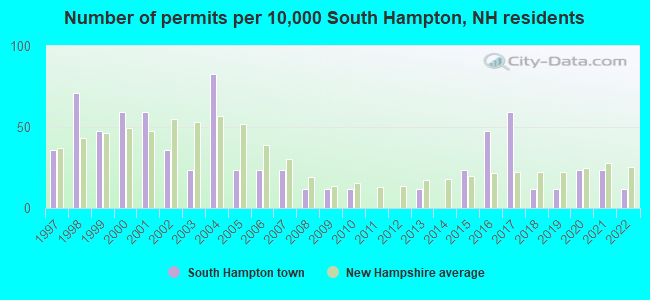
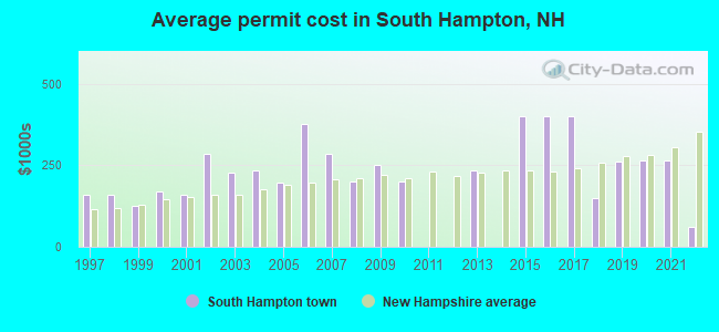
Single-family new house construction building permits:
- 2022: 1 building, cost: $60,000
- 2021: 2 buildings, average cost: $265,300
- 2020: 2 buildings, average cost: $265,300
- 2019: 1 building, cost: $262,400
- 2018: 1 building, cost: $150,000
- 2017: 5 buildings, average cost: $400,000
- 2016: 4 buildings, average cost: $400,000
- 2015: 2 buildings, average cost: $400,000
- 2013: 1 building, cost: $233,900
- 2010: 1 building, cost: $200,000
- 2009: 1 building, cost: $250,000
- 2008: 1 building, cost: $200,000
- 2007: 2 buildings, average cost: $285,400
- 2006: 2 buildings, average cost: $375,500
- 2005: 2 buildings, average cost: $195,200
- 2004: 7 buildings, average cost: $233,400
- 2003: 2 buildings, average cost: $226,500
- 2002: 3 buildings, average cost: $285,800
- 2001: 5 buildings, average cost: $159,500
- 2000: 5 buildings, average cost: $168,300
- 1999: 4 buildings, average cost: $124,600
- 1998: 6 buildings, average cost: $158,300
- 1997: 3 buildings, average cost: $158,300
| Here: | 2.9% |
| New Hampshire: | 2.5% |
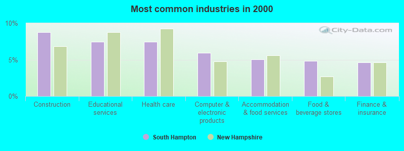
- Construction (8.8%)
- Educational services (7.5%)
- Health care (7.5%)
- Computer & electronic products (5.9%)
- Accommodation & food services (5.0%)
- Food & beverage stores (4.8%)
- Finance & insurance (4.6%)
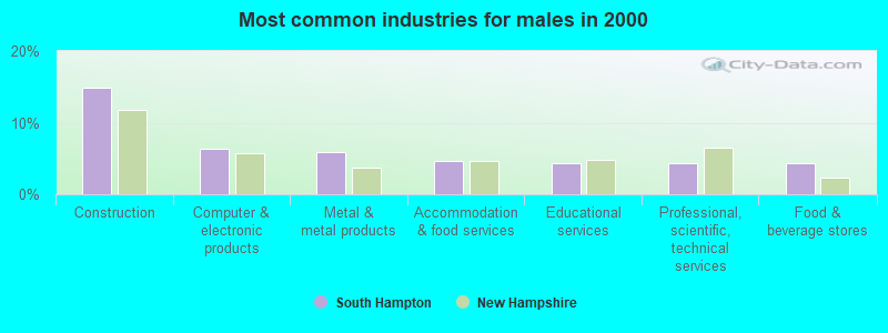
- Construction (15.0%)
- Computer & electronic products (6.3%)
- Metal & metal products (5.9%)
- Accommodation & food services (4.7%)
- Educational services (4.3%)
- Professional, scientific, technical services (4.3%)
- Food & beverage stores (4.3%)
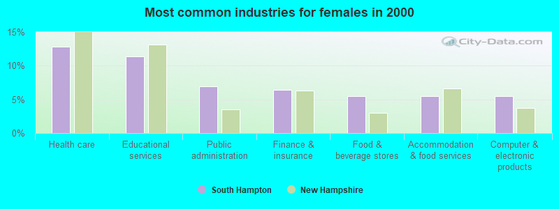
- Health care (12.9%)
- Educational services (11.4%)
- Public administration (6.9%)
- Finance & insurance (6.4%)
- Food & beverage stores (5.4%)
- Accommodation & food services (5.4%)
- Computer & electronic products (5.4%)
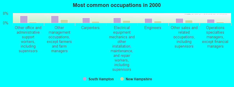
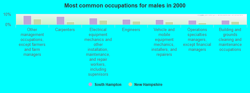
- Other office and administrative support workers, including supervisors (6.1%)
- Other management occupations, except farmers and farm managers (6.1%)
- Carpenters (4.4%)
- Electrical equipment mechanics and other installation, maintenance, and repair workers, including supervisors (4.4%)
- Engineers (3.9%)
- Other sales and related occupations, including supervisors (3.9%)
- Operations specialties managers, except financial managers (3.1%)
- Other management occupations, except farmers and farm managers (8.7%)
- Carpenters (7.9%)
- Electrical equipment mechanics and other installation, maintenance, and repair workers, including supervisors (6.3%)
- Engineers (5.1%)
- Vehicle and mobile equipment mechanics, installers, and repairers (4.7%)
- Operations specialties managers, except financial managers (4.3%)
- Building and grounds cleaning and maintenance occupations (4.3%)
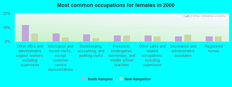
- Other office and administrative support workers, including supervisors (11.9%)
- Information and record clerks, except customer service representatives (5.9%)
- Bookkeeping, accounting, and auditing clerks (5.4%)
- Preschool, kindergarten, elementary, and middle school teachers (4.5%)
- Other sales and related occupations, including supervisors (4.5%)
- Secretaries and administrative assistants (4.0%)
- Registered nurses (4.0%)
Average climate in South Hampton, New Hampshire
Based on data reported by over 4,000 weather stations


(lower is better)
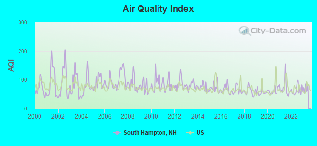
Air Quality Index (AQI) level in 2022 was 65.2. This is about average.
| City: | 65.2 |
| U.S.: | 72.6 |
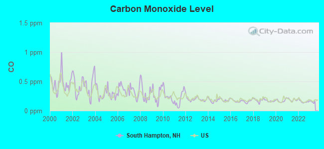
Carbon Monoxide (CO) [ppm] level in 2022 was 0.157. This is significantly better than average. Closest monitor was 17.0 miles away from the city center.
| City: | 0.157 |
| U.S.: | 0.251 |
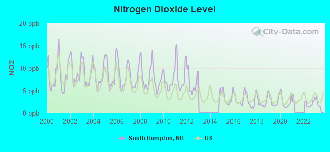
Nitrogen Dioxide (NO2) [ppb] level in 2022 was 2.05. This is significantly better than average. Closest monitor was 6.2 miles away from the city center.
| City: | 2.05 |
| U.S.: | 5.11 |
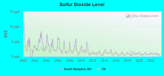
Sulfur Dioxide (SO2) [ppb] level in 2022 was 1.03. This is significantly better than average. Closest monitor was 6.2 miles away from the city center.
| City: | 1.03 |
| U.S.: | 1.51 |
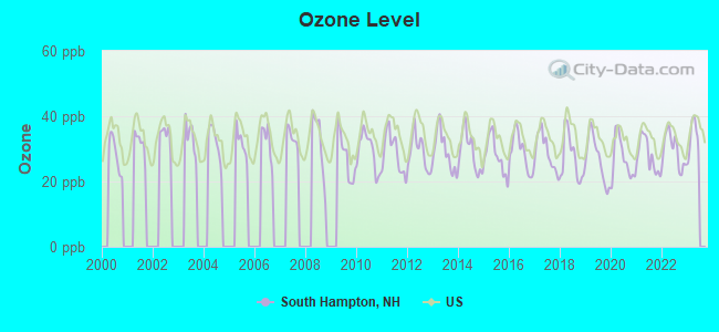
Ozone [ppb] level in 2022 was 29.5. This is about average. Closest monitor was 7.3 miles away from the city center.
| City: | 29.5 |
| U.S.: | 33.3 |
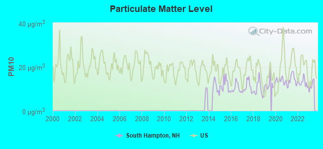
Particulate Matter (PM10) [µg/m3] level in 2022 was 12.9. This is significantly better than average. Closest monitor was 15.0 miles away from the city center.
| City: | 12.9 |
| U.S.: | 19.2 |
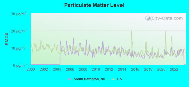
Particulate Matter (PM2.5) [µg/m3] level in 2022 was 6.62. This is better than average. Closest monitor was 10.4 miles away from the city center.
| City: | 6.62 |
| U.S.: | 8.11 |
Tornado activity:
South Hampton-area historical tornado activity is slightly above New Hampshire state average. It is 48% smaller than the overall U.S. average.
On 6/9/1953, a category F3 (max. wind speeds 158-206 mph) tornado 6.2 miles away from the South Hampton town center injured 5 people and caused between $5000 and $50,000 in damages.
On 9/29/1974, a category F3 tornado 21.7 miles away from the town center injured one person and caused between $50,000 and $500,000 in damages.
Earthquake activity:
South Hampton-area historical earthquake activity is significantly above New Hampshire state average. It is 73% smaller than the overall U.S. average.On 4/20/2002 at 10:50:47, a magnitude 5.3 (5.3 ML, Depth: 3.0 mi, Class: Moderate, Intensity: VI - VII) earthquake occurred 177.2 miles away from the city center
On 10/16/2012 at 23:12:25, a magnitude 4.7 (4.7 ML, Depth: 10.0 mi, Class: Light, Intensity: IV - V) earthquake occurred 51.9 miles away from South Hampton center
On 1/19/1982 at 00:14:42, a magnitude 4.7 (4.5 MB, 4.7 MD, 4.5 LG) earthquake occurred 53.5 miles away from South Hampton center
On 10/7/1983 at 10:18:46, a magnitude 5.3 (5.1 MB, 5.3 LG, 5.1 ML) earthquake occurred 185.2 miles away from South Hampton center
On 4/20/2002 at 10:50:47, a magnitude 5.2 (5.2 MB, 4.2 MS, 5.2 MW, 5.0 MW) earthquake occurred 177.0 miles away from South Hampton center
On 8/22/1992 at 12:20:32, a magnitude 4.8 (4.8 MB, 3.8 MS, 4.7 LG, Depth: 6.2 mi) earthquake occurred 263.3 miles away from the city center
Magnitude types: regional Lg-wave magnitude (LG), body-wave magnitude (MB), duration magnitude (MD), local magnitude (ML), surface-wave magnitude (MS), moment magnitude (MW)
Natural disasters:
The number of natural disasters in Rockingham County (26) is a lot greater than the US average (15).Major Disasters (Presidential) Declared: 17
Emergencies Declared: 9
Causes of natural disasters: Storms: 12, Floods: 9, Winter Storms: 5, Hurricanes: 4, Snowstorms: 4, Snows: 2, Winds: 2, Blizzard: 1, Snowfall: 1, Tornado: 1 (Note: some incidents may be assigned to more than one category).
Hospitals and medical centers near South Hampton:
- AMESBURY VILLAGE (Nursing Home, about 2 miles away; AMESBURY, MA)
- MERRIMACK VALLEY NSG AND REH CTR (Nursing Home, about 2 miles away; AMESBURY, MA)
- EXCELLA HOMECARE INC (Home Health Center, about 3 miles away; AMESBURY, MA)
- DSI AMESBURY RENAL CENTER (Dialysis Facility, about 3 miles away; AMESBURY, MA)
- AMESBURY HOSPITAL (Hospital, about 3 miles away; AMESBURY, MA)
- MAPLEWOOD CARE AND REHABILITATION CENTER (Nursing Home, about 3 miles away; AMESBURY, MA)
- GREENLEAF HOUSE NURSING HOME (Nursing Home, about 5 miles away; SALISBURY, MA)
Operable nuclear power plant near South Hampton:
- 6 miles: Seabrook in Seabrook, NH.
Colleges/universities with over 2000 students nearest to South Hampton:
- Northern Essex Community College (about 8 miles; Haverhill, MA; Full-time enrollment: 4,737)
- Merrimack College (about 17 miles; North Andover, MA; FT enrollment: 2,734)
- University of New Hampshire-Main Campus (about 18 miles; Durham, NH; FT enrollment: 15,243)
- North Shore Community College (about 20 miles; Danvers, MA; FT enrollment: 5,195)
- Endicott College (about 24 miles; Beverly, MA; FT enrollment: 4,064)
- University of Massachusetts-Lowell (about 25 miles; Lowell, MA; FT enrollment: 12,341)
- Salem State University (about 27 miles; Salem, MA; FT enrollment: 8,027)
Public elementary/middle school in South Hampton:
- SOUTH HAMPTON BARNARD SCHOOL (Students: 95, Location: 219 MAIN AVE., Grades: KG-8)
Points of interest:
Notable locations in South Hampton: Tuxbury Pond Camping Area (A), South Hampton Town Hall (B), South Hampton Fire / Rescue (C), South Hampton Free Public Library (D). Display/hide their locations on the map
Church in South Hampton: South Hampton Baptist Church (A). Display/hide its location on the map
Reservoir: Tuxbury Pond (A). Display/hide its location on the map
Streams, rivers, and creeks: Grassy Brook (A). Display/hide its location on the map
Parks in South Hampton include: Burrows-Brookside Sanctuary (1), Smiths Corner Historic District (2), South Hampton Town Green (3), Jewell Town District (4), Town Center Historic District (5), Highland Road Historic District (6). Display/hide their locations on the map
Birthplace of: Samuel Cate Prescott - Microbiologist, J. Warren Merrill - Politician.
Drinking water stations with addresses in South Hampton that have no violations reported:
- SOUTH HAMPTON TOWN HALL (Population served: 25, Primary Water Source Type: Groundwater)
| This town: | 2.6 people |
| New Hampshire: | 2.5 people |
| This town: | 73.0% |
| Whole state: | 66.3% |
| This town: | 7.3% |
| Whole state: | 8.3% |
Likely homosexual households (counted as self-reported same-sex unmarried-partner households)
- Lesbian couples: 0.6% of all households
- Gay men: 0.6% of all households
| This town: | 2.7% |
| Whole state: | 6.5% |
| This town: | 0.8% |
| Whole state: | 2.8% |
For population 15 years and over in South Hampton:
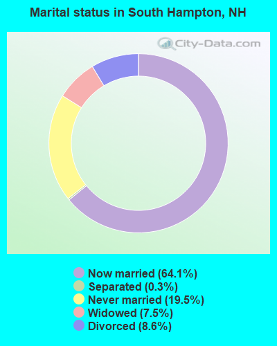
- Never married: 19.5%
- Now married: 64.1%
- Separated: 0.3%
- Widowed: 7.5%
- Divorced: 8.6%
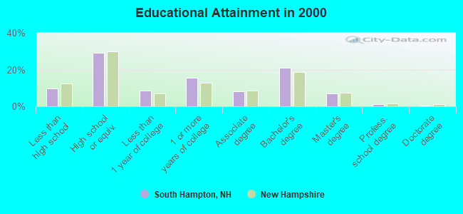
For population 25 years and over in South Hampton:
- High school or higher: 90.3%
- Bachelor's degree or higher: 29.0%
- Graduate or professional degree: 8.2%
- Unemployed: 3.2%
- Mean travel time to work (commute): 27.2 minutes
| Here: | 9.3 |
| New Hampshire average: | 10.9 |


Graphs represent county-level data. Detailed 2008 Election Results
Religion statistics for South Hampton, NH (based on Rockingham County data)


| Religion | Adherents | Congregations |
|---|---|---|
| Catholic | 84,697 | 24 |
| Mainline Protestant | 19,072 | 78 |
| Evangelical Protestant | 7,456 | 61 |
| Other | 3,490 | 20 |
| Orthodox | 200 | 1 |
| None | 180,308 | - |
Food Environment Statistics:
| Rockingham County: | 1.59 / 10,000 pop. |
| New Hampshire: | 2.14 / 10,000 pop. |
| Rockingham County: | 0.17 / 10,000 pop. |
| State: | 0.15 / 10,000 pop. |
| Rockingham County: | 1.86 / 10,000 pop. |
| New Hampshire: | 1.78 / 10,000 pop. |
| This county: | 3.31 / 10,000 pop. |
| New Hampshire: | 4.02 / 10,000 pop. |
| This county: | 9.56 / 10,000 pop. |
| New Hampshire: | 9.70 / 10,000 pop. |
| Here: | 7.6% |
| New Hampshire: | 7.6% |
| Rockingham County: | 23.3% |
| State: | 24.4% |
| This county: | 16.8% |
| New Hampshire: | 15.9% |
7.69% of this county's 2021 resident taxpayers lived in other counties in 2020 ($114,534 average adjusted gross income)
| Here: | 7.69% |
| New Hampshire average: | 7.66% |
0.01% of residents moved from foreign countries ($203 average AGI)
Rockingham County: 0.01% New Hampshire average: 0.01%
Top counties from which taxpayers relocated into this county between 2020 and 2021:
| from Essex County, MA | |
| from Hillsborough County, NH | |
| from Middlesex County, MA |
6.82% of this county's 2020 resident taxpayers moved to other counties in 2021 ($88,778 average adjusted gross income)
| Here: | 6.82% |
| New Hampshire average: | 6.80% |
0.01% of residents moved to foreign countries ($126 average AGI)
Rockingham County: 0.01% New Hampshire average: 0.01%
Top counties to which taxpayers relocated from this county between 2020 and 2021:
| to Hillsborough County, NH | |
| to Strafford County, NH | |
| to Essex County, MA |
Strongest AM radio stations in South Hampton:
- WRKO (680 AM; 50 kW; BOSTON, MA; Owner: ENTERCOM BOSTON LICENSE, LLC)
- WGIP (1540 AM; 5 kW; EXETER, NH; Owner: CAPSTAR TX LIMITED PARTNERSHIP)
- WEEI (850 AM; 50 kW; BOSTON, MA; Owner: ENTERCOM BOSTON LICENSE, LLC)
- WDER (1320 AM; 10 kW; DERRY, NH; Owner: BLOUNT COMMUNICATIONS, INC. OF NH)
- WBZ (1030 AM; 50 kW; BOSTON, MA; Owner: INFINITY BROADCASTING OPERATIONS, INC.)
- WWZN (1510 AM; 50 kW; BOSTON, MA; Owner: ROSE CITY RADIO CORPORATION)
- WKOX (1200 AM; 50 kW; FRAMINGHAM, MA; Owner: CAPSTAR TX LIMITED PARTNERSHIP)
- WBIX (1060 AM; 40 kW; NATICK, MA; Owner: LANGER BROADCASTING CORPORATION)
- WNBP (1450 AM; 1 kW; NEWBURYPORT, MA; Owner: RADIO NEWBURYPORT, LLC)
- WCEC (1110 AM; daytime; 5 kW; SALEM, NH; Owner: COSTA-EAGLE RADIO VENTURES LTD PARTNERSHIP)
- WCRN (830 AM; 50 kW; WORCESTER, MA; Owner: CARTER BROADCASTING CORPORATION)
- WGIN (930 AM; 10 kW; ROCHESTER, NH; Owner: CAPSTAR TX LIMITED PARTNERSHIP)
- WRCA (1330 AM; 25 kW; WALTHAM, MA; Owner: WRCA LICENSE, LLC)
Strongest FM radio stations in South Hampton:
- WNEF (91.7 FM; NEWBURYPORT, MA; Owner: UNIVERSITY OF MASSACHUSETTS)
- WSAK (102.1 FM; HAMPTON, NH; Owner: CITADEL BROADCASTING COMPANY)
- WXRV (92.5 FM; HAVERHILL, MA; Owner: BEANPOT BROADCASTING CORP.)
- WERZ (107.1 FM; EXETER, NH; Owner: CAPSTAR TX LIMITED PARTNERSHIP)
- WHEB (100.3 FM; PORTSMOUTH, NH; Owner: CAPSTAR TX LIMITED PARTNERSHIP)
- WKLB-FM (99.5 FM; LOWELL, MA; Owner: GREATER BOSTON RADIO, INC.)
- W227AM (93.3 FM; ANDOVER, MA; Owner: GREATER BOSTON RADIO, INC.)
- WGIR-FM (101.1 FM; MANCHESTER, NH; Owner: CAPSTAR TX LIMITED PARTNERSHIP)
- WXKS-FM (107.9 FM; MEDFORD, MA; Owner: AMFM RADIO LICENSES, L.L.C.)
- WQLL (96.5 FM; BEDFORD, NH; Owner: SAGA COMMUNICATIONS OF NEW ENGLAND, LLC)
- WLMW (90.7 FM; MANCHESTER, NH; Owner: KNOWLEDGE FOR LIFE)
- WMJX (106.7 FM; BOSTON, MA; Owner: GREATER BOSTON RADIO, INC.)
- WQSX (93.7 FM; LAWRENCE, MA; Owner: ENTERCOM BOSTON LICENSE, LLC)
- WZID (95.7 FM; MANCHESTER, NH; Owner: SAGA COMMUNICATIONS OF NEW ENGLAND, LLC)
- WFEX (92.1 FM; PETERBOROUGH, NH; Owner: FNX BROADCASTING OF NEW HAMPSHIRE LLC)
- WUBB (95.3 FM; YORK CENTER, ME; Owner: CAPSTAR TX LIMITED PARTNERSHIP)
- WSCY (106.9 FM; MOULTONBOROUGH, NH; Owner: NORTHEAST COMMUNICATIONS CORPORATION)
- WBMX (98.5 FM; BOSTON, MA; Owner: INFINITY RADIO OPERATIONS INC.)
- WJMN (94.5 FM; BOSTON, MA; Owner: AMFM RADIO LICENSES, L.L.C.)
- WCRB (102.5 FM; WALTHAM, MA; Owner: CHARLES RIVER BROADCASTING WCRB LICE)
TV broadcast stations around South Hampton:
- WHDN-LP (Channel 26; BOSTON, MA; Owner: GUENTER MARKSTEINER)
- WFXZ-CA (Channel 24; BOSTON, MA; Owner: BOSTON BROADCASTING CORP.)
- WMEA-TV (Channel 26; BIDDEFORD, ME; Owner: MAINE PUBLIC BROADCASTING CORP.)
- WCVB-TV (Channel 5; BOSTON, MA; Owner: WCVB HEARST-ARGYLE TV, INC.)
- WGBH-TV (Channel 2; BOSTON, MA; Owner: WGBH EDUCATIONAL FOUNDATION)
- WHDH-TV (Channel 7; BOSTON, MA; Owner: WHDH-TV)
- WMFP (Channel 62; LAWRENCE, MA; Owner: WSAH LICENSE, INC.)
- WSBK-TV (Channel 38; BOSTON, MA; Owner: VIACOM INC.)
- WLVI-TV (Channel 56; CAMBRIDGE, MA; Owner: WLVI, INC.)
- WBZ-TV (Channel 4; BOSTON, MA; Owner: VIACOM INC.)
- WGBX-TV (Channel 44; BOSTON, MA; Owner: WGBH EDUCATIONAL FOUNDATION)
- WENH-TV (Channel 11; DURHAM, NH; Owner: UNIVERSITY OF NEW HAMPSHIRE)
- WFXT (Channel 25; BOSTON, MA; Owner: FOX TELEVISION STATIONS INC.)
- WBPX (Channel 68; BOSTON, MA; Owner: PAXSON BOSTON-68 LICENSE, INC.)
- WUTF (Channel 66; MARLBOROUGH, MA; Owner: TELEFUTURA BOSTON LLC)
- WNDS (Channel 50; DERRY, NH; Owner: CTV OF DERRY, INC)
- WTMU-LP (Channel 32; BOSTON, MA; Owner: ZGS BOSTON, INC.)
- WCEA-LP (Channel 58; BOSTON, MA; Owner: CHANNEL 19 TV CORPORATION)
South Hampton fatal accident list:
- National Bridge Inventory (NBI) Statistics
- 4Number of bridges
- 13ft / 3.6mTotal length
- $12,568,000Total costs
- 2,275Total average daily traffic
- 89Total average daily truck traffic
- 3,365Total future (year 2042) average daily traffic
FCC Registered Amateur Radio Licenses:
6- Call Sign: N1ZQG, Grant Date: 08/08/1997, Expiration Date: 08/08/2007, Cancellation Date: 08/11/2009, Registrant: Jonathan D Baker, 304 Main Ave, South Hampton, NH 03827
- Call Sign: W1KGH, Grant Date: 05/22/1990, Expiration Date: 05/22/2000, Cancellation Date: 05/23/2002, Registrant: Randall H Spooner, Rfd 2 Box 459 Locust St, South Hampton, NH 03827
- Call Sign: WA1OWH, Licensee ID: L00247122, Grant Date: 07/29/2021, Expiration Date: 07/29/2031, Certifier: Peter A Perkins, Registrant: Peter A Perkins, 129 Hilldale Ave., South Hampton, NH 03827
- Call Sign: KC1LOZ, Licensee ID: L02272562, Grant Date: 06/14/2019, Expiration Date: 06/14/2029, Certifier: Jeffrey A Mertinooke, Registrant: Jeffrey A Mertinooke, 291 Main Ave, South Hampton, NH 03827
- Call Sign: KC1LPB, Licensee ID: L02272564, Grant Date: 06/14/2019, Expiration Date: 06/14/2029, Certifier: Heidi Mertinooke, Registrant: Heidi Mertinooke, 291 Main Ave, South Hampton, NH 03827
- Call Sign: KC1PSZ, Licensee ID: L02479520, Grant Date: 08/30/2021, Expiration Date: 08/30/2031, Certifier: Liam T Stone, Registrant: Liam T Stone, 7 Exeter Rd, South Hampton, NH 03827
FAA Registered Aircraft:
3- Aircraft: PIPER J3C-65 (Category: Land, Seats: 2, Weight: Up to 12,499 Pounds, Speed: 67 mph), Engine: CONT MOTOR A&C65 SERIES (65 HP) (Reciprocating)
N-Number: 10036, N10036, N-10036, Serial Number: 11906, Year manufactured: 1944, Airworthiness Date: 09/11/1972, Certificate Issue Date: 03/14/2014
Registrant (Individual): Thomas J Murray, 219 Hilldale Ave, South Hampton, NH 03827 - Aircraft: CHAMPION 7ECA (Category: Land, Seats: 2, Weight: Up to 12,499 Pounds, Speed: 90 mph), Engine: CONT MOTOR 0-200 SERIES (100 HP) (Reciprocating)
N-Number: 2587F, N2587F, N-2587F, Serial Number: 218, Year manufactured: 1965, Airworthiness Date: 05/12/1965, Certificate Issue Date: 06/17/1994
Registrant (Individual): Albert J Jr Theriault, 117 Woodman Rd, South Hampton, NH 03827 - Aircraft: THOMAS J MURRAY CLIPWING (Category: Land, Seats: 2, Weight: Up to 12,499 Pounds), Engine: Reciprocating
N-Number: 57TM, N57TM, N-57TM, Serial Number: 002, Certificate Issue Date: 09/14/2020
Registrant (Individual): Thomas J Murray, 219 Hilldale Ave, South Hampton, NH 03827
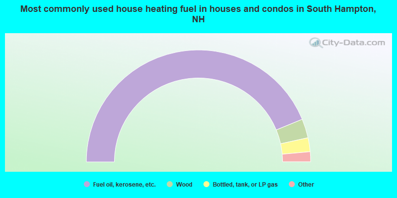
- 87.5%Fuel oil, kerosene, etc.
- 5.5%Wood
- 4.0%Bottled, tank, or LP gas
- 1.5%Utility gas
- 1.5%Electricity
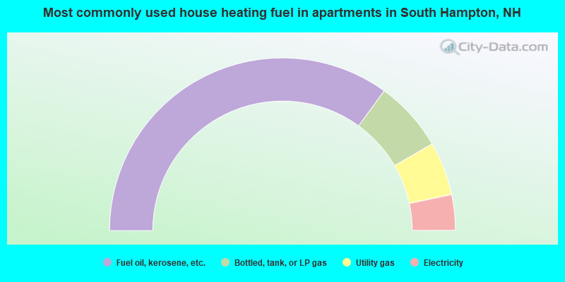
- 70.0%Fuel oil, kerosene, etc.
- 13.3%Bottled, tank, or LP gas
- 10.0%Utility gas
- 6.7%Electricity
South Hampton compared to New Hampshire state average:
- Median house value above state average.
- Unemployed percentage significantly below state average.
- Black race population percentage below state average.
- Hispanic race population percentage significantly below state average.
- Foreign-born population percentage significantly below state average.
- Renting percentage below state average.
- Length of stay since moving in significantly above state average.
- Number of rooms per house significantly below state average.
- House age significantly below state average.

|
Total of 5 patent applications in 2008-2024.