Santa Maria Valley, California
Submit your own pictures of this place and show them to the world
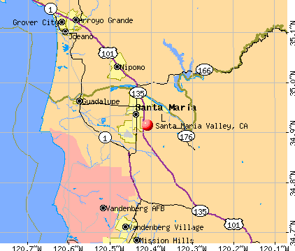
- OSM Map
- General Map
- Google Map
- MSN Map
| Males: 55,681 | |
| Females: 55,290 |
| Median resident age: | 32.1 years |
| California median age: | 33.3 years |
Zip code: 93454
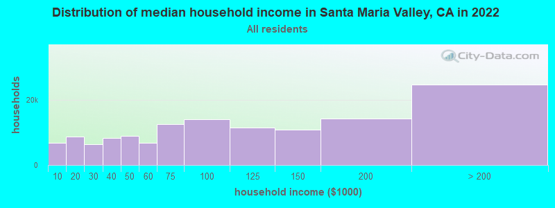
| Santa Maria Valley: | $80,525 |
| CA: | $91,551 |
Estimated per capita income in 2022: $31,951 (it was $16,457 in 2000)
Santa Maria Valley CCD income, earnings, and wages data
Estimated median house or condo value in 2022: $423,529 (it was $150,200 in 2000)
| Santa Maria Valley: | $423,529 |
| CA: | $715,900 |
Mean prices in 2022: all housing units: over $1,000,000; detached houses: over $1,000,000; townhouses or other attached units: $846,704; in 2-unit structures: $831,856; in 3-to-4-unit structures: $952,887; in 5-or-more-unit structures: $595,438; mobile homes: $232,814; occupied boats, rvs, vans, etc.: $45,964
Santa Maria Valley, CA residents, houses, and apartments details
Detailed information about poverty and poor residents in Santa Maria Valley, CA
Compare current foreclosures near Santa Maria Valley, CA:
| Photo | Address | Area | Beds / Baths | Price | Details |
|---|---|---|---|---|---|

|
#1
Las Posas Ave
Santa Maria, CA 93458
|
2,250 sq. feet
|
2 baths 3 beds |
show details | |

|
#2
N College Dr
Santa Maria, CA 93454
|
1,860 sq. feet
|
1 baths 4 beds |
show details | |

|
#3
S Bradley Rd
Santa Maria, CA 93455
|
1,196 sq. feet
|
2 baths 4 beds |
show details | |

|
#4
Viola Ct
Nipomo, CA 93444
|
1,782 sq. feet
|
2 baths 3 beds |
show details | |

|
#5
Ibis Cir
Guadalupe, CA 93434
|
1,532 sq. feet
|
2 baths 3 beds |
show details | |

|
#6
La Tijera Ct
Oceano, CA 93445
|
1,161 sq. feet
|
1 baths 3 beds |
show details | |

|
#7
Jupiter Dr
Nipomo, CA 93444
|
2,427 sq. feet
|
2 baths 3 beds |
show details | |

|
#8
W Williams St
Santa Maria, CA 93458
|
1,316 sq. feet
|
2 baths 3 beds |
show details | |

|
#9
N Railroad Ave
Santa Maria, CA 93458
|
1,897 sq. feet
|
3 baths 5 beds |
show details | |

|
#10
Pino Solo Dr
Santa Maria, CA 93455
|
2,143 sq. feet
|
3 baths 5 beds |
show details |
| Photo | Address | Area | Beds / Baths | Price | Details |
|---|---|---|---|---|---|

|
#11
Pomeroy Rd
Arroyo Grande, CA 93420
|
1,607 sq. feet
|
3 baths 5 beds |
show details | |

|
#12
E Branch St
Nipomo, CA 93444
|
1,887 sq. feet
|
2 baths 4 beds |
show details | |

|
#13
E Branch St
Nipomo, CA 93444
|
1,120 sq. feet
|
2 baths 3 beds |
show details | |

|
#14
La Serenata Way
Nipomo, CA 93444
|
2,331 sq. feet
|
3 baths 3 beds |
show details | |

|
#15
Southland St
Nipomo, CA 93444
|
934 sq. feet
|
1 baths 2 beds |
show details | |

|
#16
E Alvin Ave
Santa Maria, CA 93454
|
1,104 sq. feet
|
2 baths 3 beds |
show details | |

|
#17
January St
Nipomo, CA 93444
|
1,803 sq. feet
|
2 baths 3 beds |
show details | |

|
#18
Kent St
Nipomo, CA 93444
|
1,160 sq. feet
|
2 baths 3 beds |
show details | |

|
#19
Viola Ct
Nipomo, CA 93444
|
1,782 sq. feet
|
2 baths 3 beds |
show details | |

|
#20
Hunter Ridge Ln
Nipomo, CA 93444
|
2,388 sq. feet
|
2 baths 3 beds |
show details |
| Photo | Address | Area | Beds / Baths | Price | Details |
|---|---|---|---|---|---|

|
#21
Valley Oaks
Arroyo Grande, CA 93420
|
3,722 sq. feet
|
3 baths 4 beds |
show details | |

|
#22
Larkspur Dr
Santa Maria, CA 93455
|
1,682 sq. feet
|
2 baths 3 beds |
show details | |

|
#23
Quarterhorse Way
Arroyo Grande, CA 93420
|
3,172 sq. feet
|
2 baths 3 beds |
show details | |

|
#24
Chaparral St
Santa Maria, CA 93454
|
1,963 sq. feet
|
2 baths 4 beds |
show details | |

|
#25
Mariah Dr
Santa Maria, CA 93454
|
- sq. feet
|
2 baths 3 beds |
show details | |

|
#26
Marvin St
Santa Maria, CA 93455
|
- sq. feet
|
1 baths 3 beds |
show details | |

|
#27
Terrace Ave
Santa Maria, CA 93455
|
- sq. feet
|
3 baths 3 beds |
show details | |

|
#28
Mary Dr
Santa Maria, CA 93458
|
- sq. feet
|
2 baths 3 beds |
show details | |

|
#29
W Creston St
Santa Maria, CA 93458
|
- sq. feet
|
2 baths 3 beds |
show details | |

|
#30
Satinwood Rd
Santa Maria, CA 93455
|
- sq. feet
|
2 baths 4 beds |
show details |
| Photo | Address | Area | Beds / Baths | Price | Details |
|---|---|---|---|---|---|

|
#31
Arriba Way
Santa Maria, CA 93458
|
- sq. feet
|
2 baths 3 beds |
show details | |

|
#32
Raven Ct
Santa Maria, CA 93454
|
- sq. feet
|
3 baths 3 beds |
show details | |

|
#33
E Riddering St
Santa Maria, CA 93455
|
- sq. feet
|
2 baths 3 beds |
show details | |

|
#34
Woodlawn Dr
Santa Maria, CA 93458
|
- sq. feet
|
2 baths 4 beds |
show details | |

|
#35
Hanover Way
Santa Maria, CA 93458
|
- sq. feet
|
2 baths 3 beds |
show details | |

|
#36
Inger Dr
Santa Maria, CA 93454
|
- sq. feet
|
2 baths 3 beds |
show details | |

|
#37
Amber Ln
Santa Maria, CA 93454
|
- sq. feet
|
2 baths 3 beds |
show details | |

|
#38
Santa Maria Way Unit 207a
Santa Maria, CA 93455
|
- sq. feet
|
1 baths 2 beds |
show details | |

|
#39
Woodhaven Ct
Santa Maria, CA 93455
|
- sq. feet
|
2 baths 3 beds |
show details | |

|
#40
Lupin Ln
Santa Maria, CA 93455
|
- sq. feet
|
2 baths 4 beds |
show details |
| Photo | Address | Area | Beds / Baths | Price | Details |
|---|---|---|---|---|---|

|
#41
Dejoy St
Santa Maria, CA 93458
|
- sq. feet
|
2 baths 3 beds |
show details | |

|
#42
Alamo
Lompoc, CA 93436
|
- sq. feet
|
2 baths 3 beds |
show details | |

|
#43
Tepusquet Rd
Santa Maria, CA 93454
|
- sq. feet
|
2 baths 4 beds |
show details | |

|
#44
Via Rosa
Santa Maria, CA 93458
|
- sq. feet
|
2 baths 3 beds |
show details | |

|
#45
Boardwalk Ln
Santa Maria, CA 93455
|
- sq. feet
|
2 baths 3 beds |
show details | |

|
#46
Pinnacle Dr
Santa Maria, CA 93458
|
- sq. feet
|
2 baths 3 beds |
show details | |

|
#47
Alba Ct
Santa Maria, CA 93458
|
- sq. feet
|
3 baths 4 beds |
show details | |

|
#48
S Bradley Rd
Santa Maria, CA 93455
|
- sq. feet
|
2 baths 3 beds |
show details | |

|
#49
Barnette Rd
Santa Maria, CA 93455
|
- sq. feet
|
2 baths 3 beds |
show details | |

|
Check over 1 million property listings on Foreclosure.com!
|
browse all offers | |||

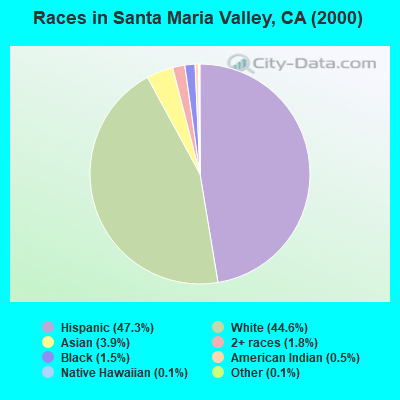
- 52,44447.3%Hispanic
- 49,36444.6%White alone
- 4,3593.9%Asian alone
- 2,0371.8%Two or more races
- 1,7131.5%Black alone
- 5990.5%American Indian alone
- 1430.1%Native Hawaiian and Other
Pacific Islander alone - 1140.1%Other race alone
 Recent articles from our blog. Our writers, many of them Ph.D. graduates or candidates, create easy-to-read articles on a wide variety of topics.
Current Local Time: PST time zone
Land area: 213.2 square miles.
Population density: 521 people per square mile (low).
| Santa Maria Valley CCD: | 0.9% ($1,306) |
| California: | 0.8% ($1,564) |
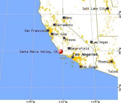
Nearest city with pop. 200,000+: Bakersfield, CA  (83.7 miles , pop. 247,057).
Nearest city with pop. 1,000,000+: Los Angeles, CA (129.3 miles , pop. 3,694,820).
Nearest cities:
)Latitude: 34.91 N, Longitude: 120.41 W
Area code commonly used in this area: 805

| Here: | 4.5% |
| California: | 5.1% |
- Agriculture, forestry, fishing & hunting (15.6%)
- Educational services (6.9%)
- Accommodation & food services (6.6%)
- Health care (6.3%)
- Construction (6.2%)
- Public administration (4.8%)
- Administrative & support & waste management services (4.3%)
- Agriculture, forestry, fishing & hunting (19.6%)
- Construction (10.0%)
- Public administration (5.8%)
- Accommodation & food services (5.1%)
- Administrative & support & waste management services (4.7%)
- Transportation equipment (3.8%)
- Educational services (3.7%)
- Health care (12.1%)
- Educational services (11.0%)
- Agriculture, forestry, fishing & hunting (10.4%)
- Accommodation & food services (8.5%)
- Social assistance (4.9%)
- Finance & insurance (4.3%)
- Administrative & support & waste management services (3.9%)
- Agricultural workers, including supervisors (13.3%)
- Other sales and related occupations, including supervisors (4.2%)
- Building and grounds cleaning and maintenance occupations (3.9%)
- Other production occupations, including supervisors (3.4%)
- Other office and administrative support workers, including supervisors (3.3%)
- Retail sales workers, except cashiers (3.1%)
- Other management occupations, except farmers and farm managers (3.1%)

- Agricultural workers, including supervisors (16.6%)
- Driver/sales workers and truck drivers (5.1%)
- Building and grounds cleaning and maintenance occupations (4.3%)
- Other production occupations, including supervisors (4.2%)
- Other sales and related occupations, including supervisors (4.1%)
- Other management occupations, except farmers and farm managers (3.7%)
- Vehicle and mobile equipment mechanics, installers, and repairers (3.3%)
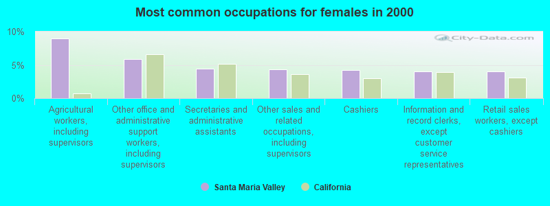
- Agricultural workers, including supervisors (8.9%)
- Other office and administrative support workers, including supervisors (5.8%)
- Secretaries and administrative assistants (4.5%)
- Other sales and related occupations, including supervisors (4.3%)
- Cashiers (4.2%)
- Information and record clerks, except customer service representatives (4.0%)
- Retail sales workers, except cashiers (4.0%)
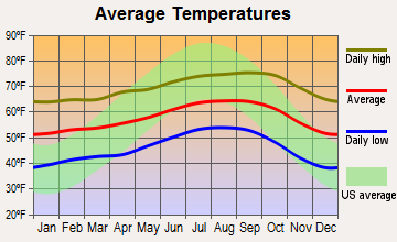
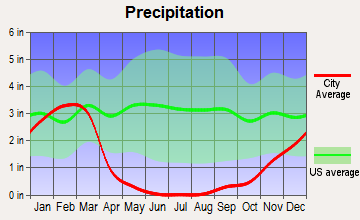
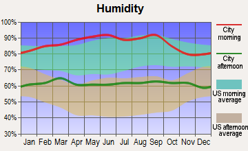
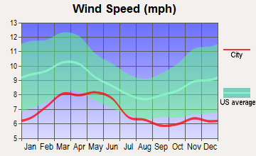
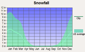
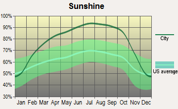
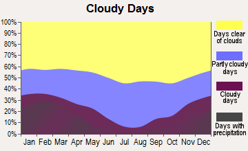
Average climate in Santa Maria Valley, California
Based on data reported by over 4,000 weather stations
(lower is better)
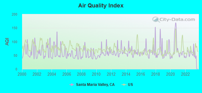
Air Quality Index (AQI) level in 2022 was 55.8. This is better than average.
| City: | 55.8 |
| U.S.: | 72.6 |
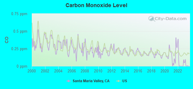
Carbon Monoxide (CO) [ppm] level in 2022 was 0.0525. This is significantly better than average. Closest monitor was 2.5 miles away from the city center.
| City: | 0.0525 |
| U.S.: | 0.2513 |
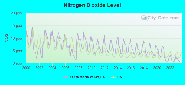
Nitrogen Dioxide (NO2) [ppb] level in 2022 was 1.61. This is significantly better than average. Closest monitor was 0.8 miles away from the city center.
| City: | 1.61 |
| U.S.: | 5.11 |
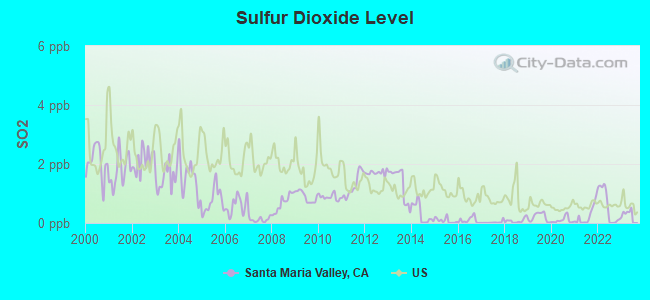
Sulfur Dioxide (SO2) [ppb] level in 2022 was 0.574. This is significantly better than average. Closest monitor was 2.8 miles away from the city center.
| City: | 0.574 |
| U.S.: | 1.515 |
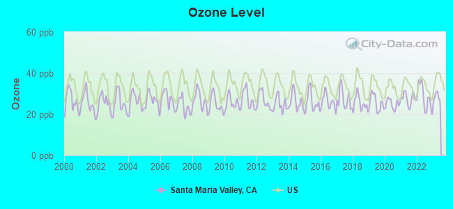
Ozone [ppb] level in 2022 was 28.1. This is about average. Closest monitor was 0.8 miles away from the city center.
| City: | 28.1 |
| U.S.: | 33.3 |
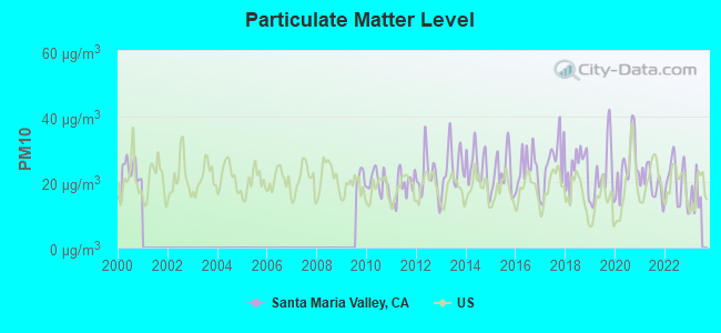
Particulate Matter (PM10) [µg/m3] level in 2022 was 20.5. This is about average. Closest monitor was 2.1 miles away from the city center.
| City: | 20.5 |
| U.S.: | 19.2 |
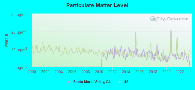
Particulate Matter (PM2.5) [µg/m3] level in 2022 was 6.28. This is better than average. Closest monitor was 2.1 miles away from the city center.
| City: | 6.28 |
| U.S.: | 8.11 |
Earthquake activity:
Santa Maria Valley-area historical earthquake activity is significantly above California state average. It is 6605% greater than the overall U.S. average.On 7/21/1952 at 11:52:14, a magnitude 7.7 (7.7 UK, Class: Major, Intensity: VIII - XII) earthquake occurred 80.1 miles away from the city center, causing $50,000,000 total damage
On 11/4/1927 at 13:51:53, a magnitude 7.5 (7.5 UK) earthquake occurred 35.3 miles away from Santa Maria Valley center
On 4/18/1906 at 13:12:21, a magnitude 7.9 (7.9 UK) earthquake occurred 257.5 miles away from the city center, causing $524,000,000 total damage
On 6/28/1992 at 11:57:34, a magnitude 7.6 (6.2 MB, 7.6 MS, 7.3 MW, Depth: 0.7 mi) earthquake occurred 226.6 miles away from Santa Maria Valley center, causing 3 deaths (1 shaking deaths, 2 other deaths) and 400 injuries, causing $100,000,000 total damage and $40,000,000 insured losses
On 10/16/1999 at 09:46:44, a magnitude 7.4 (6.3 MB, 7.4 MS, 7.2 MW, 7.3 ML) earthquake occurred 227.6 miles away from the city center
On 10/18/1989 at 00:04:15, a magnitude 7.1 (6.5 MB, 7.1 MS, 6.9 MW, 7.0 ML) earthquake occurred 169.9 miles away from the city center, causing 62 deaths (62 shaking deaths) and 3757 injuries, causing $1,305,032,704 total damage
Magnitude types: body-wave magnitude (MB), local magnitude (ML), surface-wave magnitude (MS), moment magnitude (MW)
Natural disasters:
The number of natural disasters in Santa Barbara County (31) is a lot greater than the US average (15).Major Disasters (Presidential) Declared: 19
Emergencies Declared: 3
Causes of natural disasters: Floods: 17, Fires: 10, Storms: 8, Winter Storms: 8, Mudslides: 7, Landslides: 4, Drought: 1, Earthquake: 1, Freeze: 1, Hurricane: 1, Tornado: 1, Wind: 1, Other: 1 (Note: some incidents may be assigned to more than one category).
Hospitals and medical centers near Santa Maria Valley:
- CENTRAL COAST KIDNEY DISEASE CENTER (Dialysis Facility, about 2 miles away; SANTA MARIA, CA)
- MARIAN HOSPITAL HOMECARE AND HOSPICE (Home Health Center, about 2 miles away; SANTA MARIA, CA)
- VALLEY COMMUNITY HOSPITAL D/P SNF (Nursing Home, about 2 miles away; SANTA MARIA, CA)
- VILLA MARIA HEALTHCARE CENTER (Nursing Home, about 2 miles away; SANTA MARIA, CA)
- MARIAN MEDICAL CENTER D/P SNF (Nursing Home, about 3 miles away; SANTA MARIA, CA)
- MARIAN REGIONAL MEDICAL CENTER Acute Care Hospitals (about 3 miles away; SANTA MARIA, CA)
- ENDOSCOPY SURGERY CENTER OF SANTA MARIA (Hospital, about 3 miles away; SANTA MARIA, CA)
Amtrak stations near Santa Maria Valley:
- 3 miles: SANTA MARIA (CYPRESS ST. & NICHOLSON AVE.) - Bus Station . Services: fully wheelchair accessible, public payphones, free short-term parking, call for taxi service, public transit connection.
- 10 miles: GUADALUPE/SANTA MARIA (SANTA MARIA, 330 GUADELUPE ST.)
- 19 miles: LOMPOC (LAUREL & N. H STS.) - Bus Station . Services: fully wheelchair accessible, public payphones, snack bar, free short-term parking, call for taxi service.
Colleges/universities with over 2000 students nearest to Santa Maria Valley:
- Allan Hancock College (about 3 miles; Santa Maria, CA; Full-time enrollment: 6,639)
- California Polytechnic State University-San Luis Obispo (about 31 miles; San Luis Obispo, CA; FT enrollment: 17,345)
- Cuesta College (about 35 miles; San Luis Obispo, CA; FT enrollment: 6,518)
- University of California-Santa Barbara (about 48 miles; Santa Barbara, CA; FT enrollment: 22,806)
- Santa Barbara City College (about 54 miles; Santa Barbara, CA; FT enrollment: 12,568)
- Taft College (about 57 miles; Taft, CA; FT enrollment: 2,121)
- California State University-Bakersfield (about 80 miles; Bakersfield, CA; FT enrollment: 7,564)
Points of interest:
Notable locations in Santa Maria Valley: Hi-Way Drive-In (A), Rancho Maria Public Golf Course (B), Sunset Ridge Golf Course (C), Spring Harvest Berry Farms (D), Fletcher Farms (E), Sisquoc Grange (F), Gates (G), Morris Ranch (H), Battles (I), Adams Ranch (J), Santa Maria Country Club (K), Divide Substation (L), Airbase (M), Orcutt Union School District Office (N), Orcutt Branch Santa Maria Public Library (O), Allan Hancock College - Learning Resources Center (P), Veterans Memorial Hall (Q), Santa Maria Valley Chamber of Commerce and Museum (R), Santa Maria Public Library (S), Santa Maria Branch Santa Barbara County Law Library (T). Display/hide their locations on the map
Shopping Centers: Town Center West Shopping Center (1), Town and Country Shopping Center (2), Santa Maria Town Center Shopping Center (3), Oak Knoll Shopping Center South (4), Oak Knoll Shopping Center North (5), La Joya Plaza Shopping Center (6), Acorn Shopping Center (7), Western Village Shopping Center (8), Stowell Shopping Center (9). Display/hide their locations on the map
Churches in Santa Maria Valley include: First Assembly of God Church (A), Aurora Korean Baptist Church (B), Church of Christ (C), The Church of Jesus Christ of Latter Day Saints (D), Church of the Nazarene (E), El Camino Park Four Square Church (F), Faith Baptist Church (G), First Baptist Church (H), First Christian Church (I). Display/hide their locations on the map
Cemeteries: Ontiveros Cemetery (1), Santa Maria Cemetery (2). Display/hide their locations on the map
Rivers: Cuyama River (A), Sisquoc River (B). Display/hide their locations on the map
Parks in Santa Maria Valley include: James Hagerman Softball Complex (1), Miramonte Park North (2), Miramonte Park South (3), Adam Park (4), Alice Threfts Park (5), Armstrong Park (6), Atkinson Park (7), Buena Vista Park (8), Grogan Park (9). Display/hide their locations on the map
| This place: | 3.2 people |
| California: | 2.9 people |
| This place: | 50.8% |
| Whole state: | 69.4% |
| This place: | 5.2% |
| Whole state: | 5.9% |
Likely homosexual households (counted as self-reported same-sex unmarried-partner households)
- Lesbian couples: 0.3% of all households
- Gay men: 0.2% of all households
| This place: | 15.5% |
| Whole state: | 14.2% |
| This place: | 5.8% |
| Whole state: | 6.3% |
People in group quarters in Santa Maria Valley in 2000:
- 923 people in local jails and other confinement facilities (including police lockups)
- 666 people in other noninstitutional group quarters
- 441 people in nursing homes
- 196 people in other group homes
- 84 people in orthopedic wards and institutions for the physically handicapped
- 74 people in homes or halfway houses for drug/alcohol abuse
- 65 people in other nonhousehold living situations
- 61 people in homes for the mentally retarded
- 42 people in short-term care, detention or diagnostic centers for delinquent children
- 16 people in homes for the mentally ill
- 9 people in hospitals/wards and hospices for chronically ill
- 9 people in hospices or homes for chronically ill
- 8 people in religious group quarters
- 5 people in homes for the physically handicapped
For population 15 years and over in Santa Maria Valley:
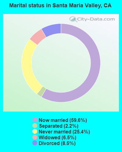
- Never married: 25.4%
- Now married: 59.6%
- Separated: 2.2%
- Widowed: 6.5%
- Divorced: 8.5%
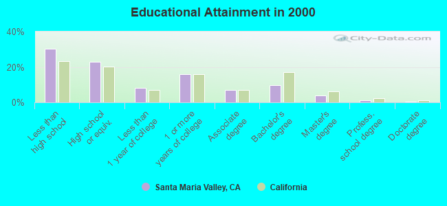
For population 25 years and over in Santa Maria Valley:
- High school or higher: 69.6%
- Bachelor's degree or higher: 15.3%
- Graduate or professional degree: 5.4%
- Unemployed: 7.8%
- Mean travel time to work (commute): 19.9 minutes

| Here: | 17.9 |
| California average: | 16.1 |
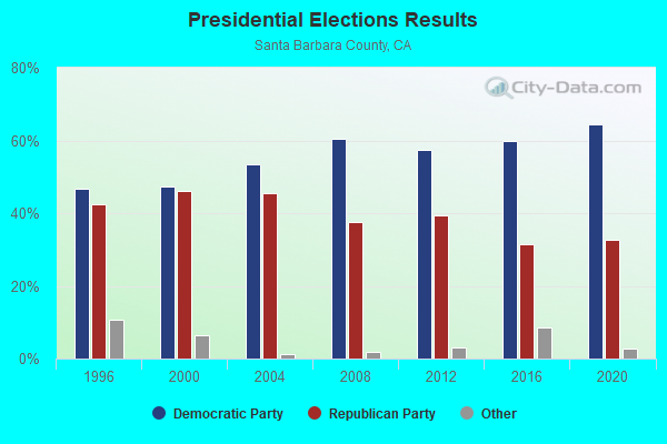
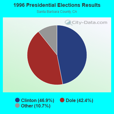
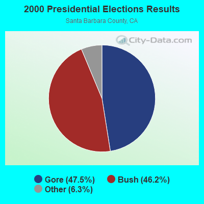
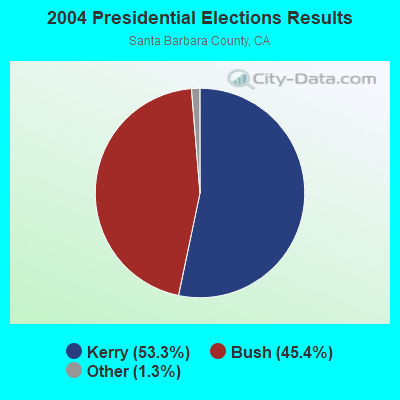
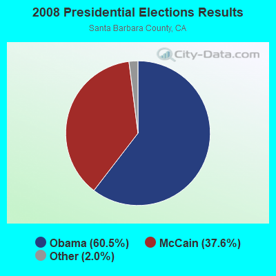
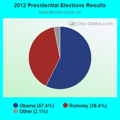
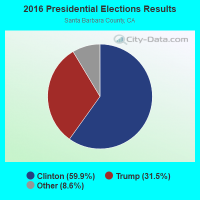
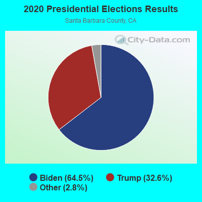
Graphs represent county-level data. Detailed 2008 Election Results
Religion statistics for Santa Maria Valley, CA (based on Santa Barbara County data)
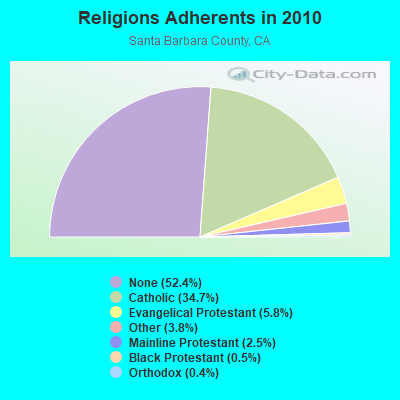
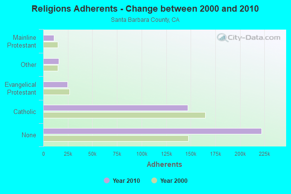
| Religion | Adherents | Congregations |
|---|---|---|
| Catholic | 146,940 | 17 |
| Evangelical Protestant | 24,775 | 161 |
| Other | 15,951 | 58 |
| Mainline Protestant | 10,610 | 43 |
| Black Protestant | 1,979 | 13 |
| Orthodox | 1,536 | 7 |
| None | 222,104 | - |
Food Environment Statistics:
| Here: | 2.61 / 10,000 pop. |
| California: | 2.14 / 10,000 pop. |
| Here: | 0.05 / 10,000 pop. |
| State: | 0.04 / 10,000 pop. |
| Santa Barbara County: | 0.75 / 10,000 pop. |
| California: | 0.62 / 10,000 pop. |
| Santa Barbara County: | 1.84 / 10,000 pop. |
| California: | 1.49 / 10,000 pop. |
| Santa Barbara County: | 9.65 / 10,000 pop. |
| State: | 7.42 / 10,000 pop. |
| Here: | 7.3% |
| State: | 7.3% |
| Santa Barbara County: | 22.2% |
| State: | 21.3% |
| Santa Barbara County: | 18.3% |
| State: | 17.9% |
4.93% of this county's 2021 resident taxpayers lived in other counties in 2020 ($102,533 average adjusted gross income)
| Here: | 4.93% |
| California average: | 5.19% |
0.04% of residents moved from foreign countries ($459 average AGI)
Santa Barbara County: 0.04% California average: 0.03%
Top counties from which taxpayers relocated into this county between 2020 and 2021:
| from Los Angeles County, CA | |
| from San Luis Obispo County, CA | |
| from Ventura County, CA |
6.09% of this county's 2020 resident taxpayers moved to other counties in 2021 ($82,188 average adjusted gross income)
| Here: | 6.09% |
| California average: | 6.14% |
0.03% of residents moved to foreign countries ($259 average AGI)
Santa Barbara County: 0.03% California average: 0.02%
Top counties to which taxpayers relocated from this county between 2020 and 2021:
| to Los Angeles County, CA | |
| to San Luis Obispo County, CA | |
| to Ventura County, CA |
Strongest AM radio stations in Santa Maria Valley:
- KGDP (660 AM; 50 kW; ORCUTT, CA; Owner: RADIO REPRESENTATIVES, INC.)
- KUHL (1440 AM; 5 kW; SANTA MARIA, CA; Owner: MAPLETON COMMUNICATIONS, LLC)
- KSMA (1240 AM; 1 kW; SANTA MARIA, CA; Owner: CLEAR CHANNEL BROADCASTING LICENSES, INC.)
- KXTK (1280 AM; 10 kW; ARROYO GRANDE, CA; Owner: PAMPLIN BROADCASTING, INC.)
- KSBQ (1480 AM; 1 kW; SANTA MARIA, CA; Owner: LAZER BROADCASTING CORP.)
- KLFF (890 AM; 5 kW; ARROYO GRANDE, CA; Owner: JERRY J. COLLINS)
- KTAP (1600 AM; daytime; 0 kW; SANTA MARIA, CA; Owner: EMERALD WAVE MEDIA)
- KERI (1180 AM; 50 kW; WASCO-GREENACRES, CA; Owner: KWSO, INC.)
- KMJ (580 AM; 50 kW; FRESNO, CA; Owner: INFINITY RADIO OPERATIONS INC.)
- KSPN (710 AM; 50 kW; LOS ANGELES, CA; Owner: KABC-AM RADIO, INC.)
- KLAC (570 AM; 50 kW; LOS ANGELES, CA; Owner: AMFM RADIO LICENSES, L.L.C.)
- KWRU (940 AM; 50 kW; FRESNO, CA)
- KIRN (670 AM; 35 kW; SIMI VALLEY, CA; Owner: LOTUS OXNARD CORP.)
Strongest FM radio stations in Santa Maria Valley:
- KSNI-FM (102.5 FM; SANTA MARIA, CA; Owner: CLEAR CHANNEL BROADCASTING LICENSES, INC.)
- K216FQ (90.9 FM; SANTA MARIA, CA; Owner: CALVARY CHAPEL OF TWIN FALLS, INC.)
- KXFM (99.1 FM; SANTA MARIA, CA; Owner: CLEAR CHANNEL BROADCASTING LICENSES, INC.)
- KIDI-FM (105.5 FM; GUADALUPE, CA; Owner: EMERALD WAVE MEDIA)
- KPAT (95.7 FM; ORCUTT, CA; Owner: AGM-BIRMINGHAM, LLC)
- KRQK (100.3 FM; LOMPOC, CA; Owner: AGM-BIRMINGHAM, L.L.C.)
- KGDP-FM (90.7 FM; SANTA MARIA, CA; Owner: PEOPLE OF ACTION)
- KBOX (104.1 FM; LOMPOC, CA; Owner: AGM-BIRMINGHAM, L.L.C.)
- KSYV (96.7 FM; SOLVANG, CA; Owner: KNIGHT BROADCASTING, INC.)
- KWSZ (105.1 FM; LOMPOC, CA; Owner: MAPLETON COMMUNICATIONS, LLC)
- KURQ (107.3 FM; GROVER BEACH, CA; Owner: CLEAR CHANNEL BROADCASTING LICENSES, INC.)
- KRAZ (105.9 FM; SANTA YNEZ, CA; Owner: KNIGHT BROADCASTING, INC.)
- KRUZ (103.3 FM; SANTA BARBARA, CA; Owner: CUMULUS LICENSING CORP.)
- KSPE-FM (94.5 FM; ELLWOOD, CA; Owner: CITICASTERS LICENSES, L.P.)
- KMGQ (97.5 FM; SANTA BARBARA, CA; Owner: CUMULUS LICENSING CORP.)
- KCSB-FM (91.9 FM; SANTA BARBARA, CA; Owner: UNIVERSITY OF CALIFORNIA)
- KSMY (106.7 FM; LOMPOC, CA; Owner: CLEAR CHANNEL BROADCASTING LICENSES, INC.)
- K216CO (91.1 FM; LOMPOC, CA; Owner: CALVARY CHAPEL OF TWIN FALLS, INC.)
- KRQZ (91.5 FM; LOMPOC, CA; Owner: TRINITY CHURCH OF THE NAZARENE)
- KSTT-FM (101.3 FM; LOS OSOS-BAYWOOD PAR, CA; Owner: CLEAR CHANNEL BROADCASTING LICENSES, INC.)
TV broadcast stations around Santa Maria Valley:
- KFUL-LP (Channel 44; SAN LUIS OBISPO, CA; Owner: KJLA, LLC)
- KSSY-LP (Channel 66; ARROYO GRANDE, CA; Owner: CHERIE ERWIN)
- KCOY-TV (Channel 12; SANTA MARIA, CA; Owner: ACKERLEY MEDIA GROUP, INC.)
- K07TA (Channel 7; SANTA MARIA, CA; Owner: RAUL AND CONSUELO PALAZUELOS)
- K51GB (Channel 51; SANTA MARIA, CA; Owner: CENTRAL COAST GOOD NEWS, INC.)
- KWSM-LP (Channel 40; SANTA MARIA, CA; Owner: GARY M. COCOLA FAMILY TRUST, GARY M. COCOLA TRUSTEE)
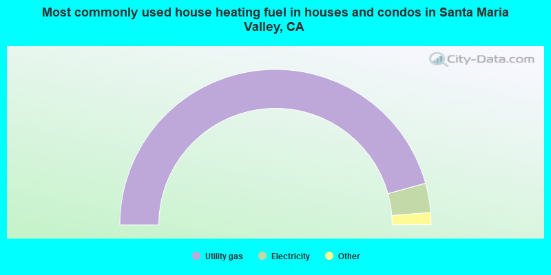
- 91.4%Utility gas
- 6.1%Electricity
- 1.1%Bottled, tank, or LP gas
- 0.7%Wood
- 0.6%No fuel used
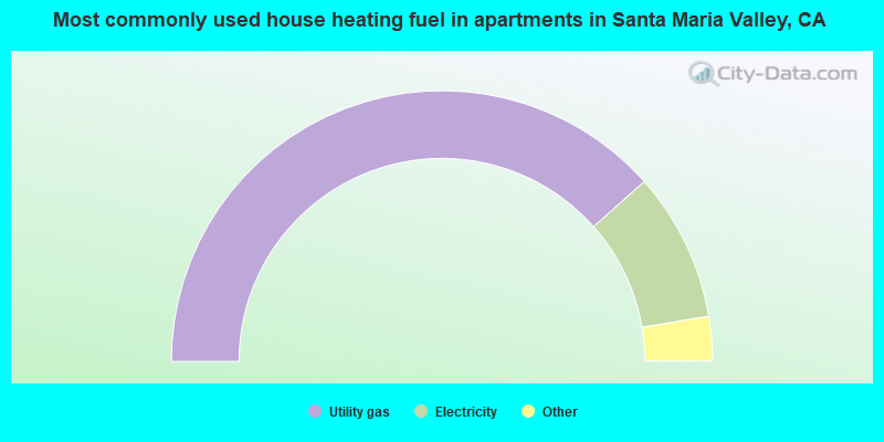
- 76.9%Utility gas
- 17.8%Electricity
- 2.4%No fuel used
- 2.3%Bottled, tank, or LP gas
- 0.3%Wood
- 0.2%Other fuel
- 0.1%Solar energy
Santa Maria Valley compared to California state average:
- Median house value below state average.
- Unemployed percentage below state average.
- Black race population percentage significantly below state average.
- Foreign-born population percentage significantly below state average.
- Renting percentage significantly below state average.
- Length of stay since moving in significantly above state average.
- Number of rooms per house significantly below state average.
- House age significantly below state average.
- Institutionalized population percentage significantly above state average.
- Percentage of population with a bachelor's degree or higher below state average.
Santa Maria Valley on our top lists:
- #1 on the list of "Top 101 cities with largest percentage of males in occupations: farmers and farm managers (population 50,000+)"
- #1 on the list of "Top 101 cities with largest percentage of females in occupations: farmers and farm managers (population 50,000+)"
- #1 on the list of "Top 101 cities with largest percentage of males in occupations: agricultural workers including supervisors (population 50,000+)"
- #2 on the list of "Top 101 cities with largest percentage of females in occupations: agricultural workers including supervisors (population 50,000+)"
- #2 on the list of "Top 101 cities with largest percentage of males in industries: groceries and related products merchant wholesalers (population 50,000+)"
- #3 on the list of "Top 101 cities with largest percentage of females in industries: groceries and related products merchant wholesalers (population 50,000+)"
- #3 on the list of "Top 101 cities with largest percentage of females in occupations: other healthcare support occupations (population 50,000+)"
- #3 on the list of "Top 101 cities with largest percentage of females in industries: other direct selling establishments (population 50,000+)"
- #3 on the list of "Top 101 cities with largest percentage of females in occupations: extraction workers (population 50,000+)"
- #3 on the list of "Top 101 cities with largest percentage of males in industries: farm supplies merchant wholesalers (population 50,000+)"
- #4 on the list of "Top 101 cities with largest percentage of females in industries: sporting goods, camera, and hobby and toy stores (population 50,000+)"
- #5 on the list of "Top 101 cities with largest percentage of females in industries: vending machine operators (population 50,000+)"
- #7 on the list of "Top 101 cities with largest percentage of males in industries: social assistance (population 50,000+)"
- #7 on the list of "Top 101 cities with largest percentage of females in industries: farm supplies merchant wholesalers (population 50,000+)"
- #7 on the list of "Top 101 cities with largest percentage of males in industries: agriculture, forestry, fishing and hunting (population 50,000+)"
- #8 on the list of "Top 101 cities with largest percentage of females in industries: beverage and tobacco products (population 50,000+)"
- #8 on the list of "Top 101 cities with largest percentage of females in industries: sewing, needlework, and piece goods stores (population 50,000+)"
- #8 on the list of "Top 101 cities with largest percentage of males in industries: petroleum and petroleum products merchant wholesalers (population 50,000+)"
- #8 on the list of "Top 101 cities with largest percentage of females in industries: food (population 50,000+)"
- #8 on the list of "Top 101 cities with largest percentage of females in industries: miscellaneous nondurable goods merchant wholesalers (population 50,000+)"
- #17 on the list of "Top 101 counties with the lowest Sulfur Oxides Annual air pollution readings in 2012 (µg/m3)"
- #32 on the list of "Top 101 counties with the highest Nitrogen Dioxide air pollution readings in 2012 (ppm)"
- #38 on the list of "Top 101 counties with the lowest number of infant deaths per 1000 residents 2007-2013 (pop. 50,000+)"
- #78 on the list of "Top 101 counties with the highest carbon monoxide air pollution readings in 2012 (ppm)"
- #81 on the list of "Top 101 counties with the largest decrease in the number of infant deaths per 1000 residents 2000-2006 to 2007-2013 (pop. 50,000+)"