Root, New York
Submit your own pictures of this town and show them to the world
- OSM Map
- Google Map
- MSN Map
Population change since 2000: -2.1%
 |
| Males: 859 | |
| Females: 856 |
| Median resident age: | 44.5 years |
| New York median age: | 40.7 years |
Zip codes: 12166.
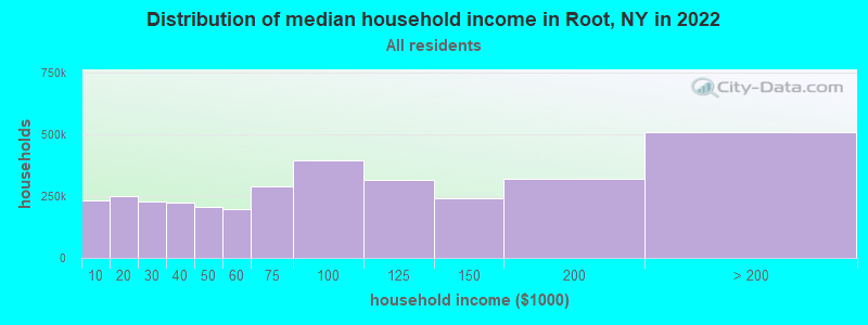
| Root: | $67,203 |
| NY: | $79,557 |
Estimated per capita income in 2022: $28,703 (it was $16,206 in 2000)
Root town income, earnings, and wages data
Estimated median house or condo value in 2022: $132,767 (it was $61,900 in 2000)
| Root: | $132,767 |
| NY: | $400,400 |
Mean prices in 2022: all housing units: $164,637; detached houses: $181,852; townhouses or other attached units: $164,701; in 2-unit structures: $120,098; in 3-to-4-unit structures: $151,547; in 5-or-more-unit structures: $210,099; mobile homes: $71,715
Detailed information about poverty and poor residents in Root, NY


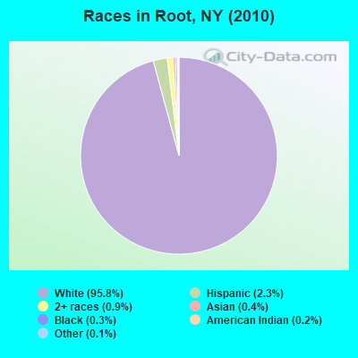
- 1,64395.8%White alone
- 392.3%Hispanic
- 150.9%Two or more races
- 70.4%Asian alone
- 60.3%Black alone
- 30.2%American Indian alone
- 20.1%Other race alone
Races in Root detailed stats: ancestries, foreign born residents, place of birth
 Recent articles from our blog. Our writers, many of them Ph.D. graduates or candidates, create easy-to-read articles on a wide variety of topics.
Ancestries: German (24.0%), Irish (12.4%), United States (12.0%), English (11.8%), Dutch (10.8%), Italian (10.0%).
Current Local Time: EST time zone
Land area: 50.8 square miles.
Population density: 34 people per square mile (very low).
20 residents are foreign born
| This town: | 1.1% |
| New York: | 20.4% |
| Root town: | 2.1% ($1,287) |
| New York: | 1.9% ($2,847) |
Nearest city with pop. 50,000+: Schenectady, NY  (28.1 miles , pop. 61,821).
Nearest city with pop. 200,000+: Bronx, NY (142.1 miles , pop. 1,332,650).
Nearest cities:
), ), ), ), ), )Latitude: 42.85 N, Longitude: 74.48 W
Area code commonly used in this area: 518
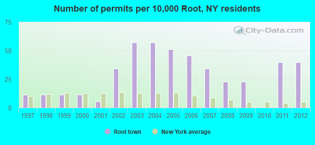
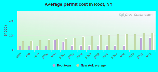
Single-family new house construction building permits:
- 2012: 7 buildings, average cost: $172,800
- 2011: 7 buildings, average cost: $172,800
- 2009: 4 buildings, average cost: $65,000
- 2008: 4 buildings, average cost: $65,000
- 2007: 6 buildings, average cost: $65,000
- 2006: 8 buildings, average cost: $65,000
- 2005: 9 buildings, average cost: $65,000
- 2004: 10 buildings, average cost: $65,000
- 2003: 10 buildings, average cost: $65,000
- 2002: 6 buildings, average cost: $116,700
- 2001: 1 building, cost: $140,000
- 2000: 2 buildings, average cost: $60,000
- 1999: 2 buildings, average cost: $60,000
- 1998: 2 buildings, average cost: $60,000
- 1997: 2 buildings, average cost: $60,000
| Here: | 5.1% |
| New York: | 4.4% |
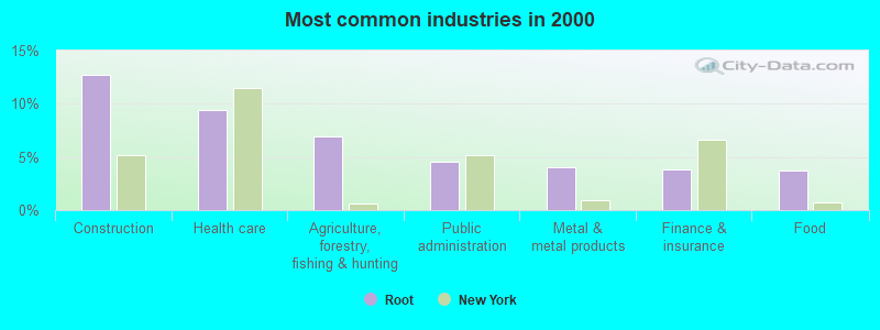
- Construction (12.7%)
- Health care (9.4%)
- Agriculture, forestry, fishing & hunting (6.9%)
- Public administration (4.6%)
- Metal & metal products (4.1%)
- Finance & insurance (3.8%)
- Food (3.7%)
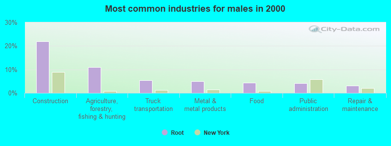
- Construction (21.9%)
- Agriculture, forestry, fishing & hunting (11.1%)
- Truck transportation (5.4%)
- Metal & metal products (5.0%)
- Food (4.3%)
- Public administration (4.1%)
- Repair & maintenance (3.2%)
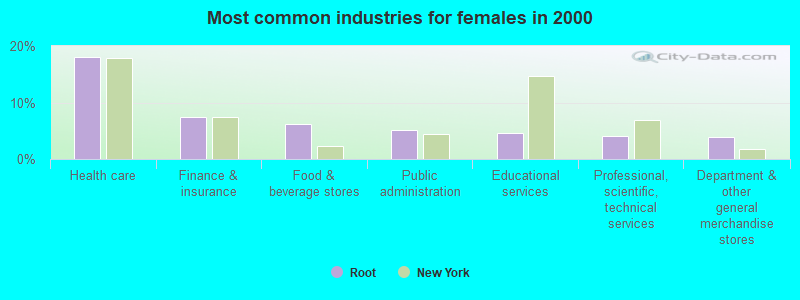
- Health care (18.0%)
- Finance & insurance (7.4%)
- Food & beverage stores (6.3%)
- Public administration (5.2%)
- Educational services (4.6%)
- Professional, scientific, technical services (4.1%)
- Department & other general merchandise stores (3.8%)
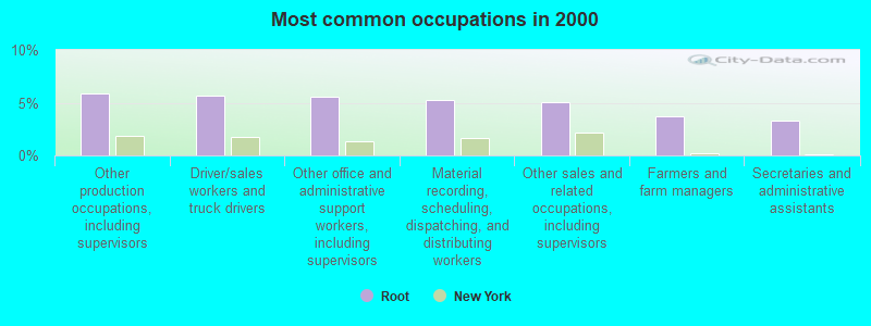
- Other production occupations, including supervisors (5.9%)
- Driver/sales workers and truck drivers (5.7%)
- Other office and administrative support workers, including supervisors (5.6%)
- Material recording, scheduling, dispatching, and distributing workers (5.3%)
- Other sales and related occupations, including supervisors (5.1%)
- Farmers and farm managers (3.7%)
- Secretaries and administrative assistants (3.3%)
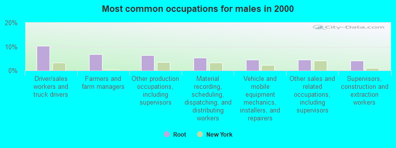
- Driver/sales workers and truck drivers (10.4%)
- Farmers and farm managers (6.8%)
- Other production occupations, including supervisors (6.3%)
- Material recording, scheduling, dispatching, and distributing workers (5.4%)
- Vehicle and mobile equipment mechanics, installers, and repairers (4.5%)
- Other sales and related occupations, including supervisors (4.5%)
- Supervisors, construction and extraction workers (4.1%)
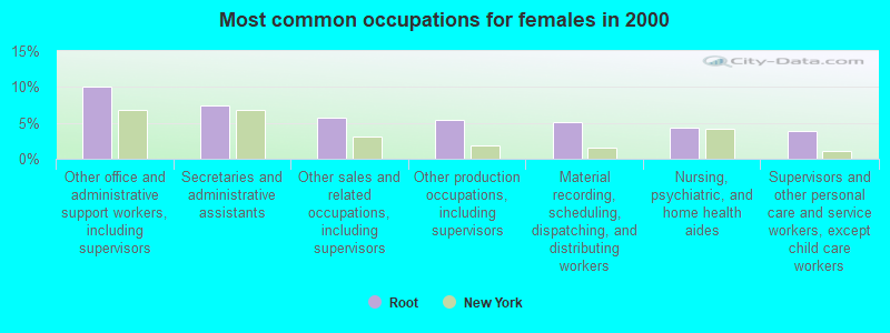
- Other office and administrative support workers, including supervisors (10.1%)
- Secretaries and administrative assistants (7.4%)
- Other sales and related occupations, including supervisors (5.7%)
- Other production occupations, including supervisors (5.4%)
- Material recording, scheduling, dispatching, and distributing workers (5.2%)
- Nursing, psychiatric, and home health aides (4.4%)
- Supervisors and other personal care and service workers, except child care workers (3.8%)
Average climate in Root, New York
Based on data reported by over 4,000 weather stations


Tornado activity:
Root-area historical tornado activity is near New York state average. It is 64% smaller than the overall U.S. average.
On 7/10/1989, a category F4 (max. wind speeds 207-260 mph) tornado 2.9 miles away from the Root town center injured 20 people and caused between $5,000,000 and $50,000,000 in damages.
On 5/31/1998, a category F3 (max. wind speeds 158-206 mph) tornado 29.5 miles away from the town center injured 3 people and caused $800,000 in damages.
Earthquake activity:
Root-area historical earthquake activity is significantly above New York state average. It is 67% smaller than the overall U.S. average.On 10/7/1983 at 10:18:46, a magnitude 5.3 (5.1 MB, 5.3 LG, 5.1 ML, Class: Moderate, Intensity: VI - VII) earthquake occurred 76.6 miles away from the city center
On 4/20/2002 at 10:50:47, a magnitude 5.3 (5.3 ML, Depth: 3.0 mi) earthquake occurred 121.4 miles away from Root center
On 4/20/2002 at 10:50:47, a magnitude 5.2 (5.2 MB, 4.2 MS, 5.2 MW, 5.0 MW) earthquake occurred 119.5 miles away from Root center
On 6/17/1991 at 08:53:16, a magnitude 4.1 (4.0 MB, 4.0 LG, Depth: 3.1 mi, Class: Light, Intensity: IV - V) earthquake occurred 18.3 miles away from the city center
On 1/19/1982 at 00:14:42, a magnitude 4.7 (4.5 MB, 4.7 MD, 4.5 LG) earthquake occurred 152.1 miles away from Root center
On 8/23/2011 at 17:51:04, a magnitude 5.8 (5.8 MW, Depth: 3.7 mi) earthquake occurred 387.1 miles away from Root center
Magnitude types: regional Lg-wave magnitude (LG), body-wave magnitude (MB), duration magnitude (MD), local magnitude (ML), surface-wave magnitude (MS), moment magnitude (MW)
Natural disasters:
The number of natural disasters in Montgomery County (22) is greater than the US average (15).Major Disasters (Presidential) Declared: 13
Emergencies Declared: 7
Causes of natural disasters: Floods: 10, Storms: 10, Hurricanes: 3, Snowstorms: 2, Tropical Storms: 2, Blizzard: 1, Power Outage: 1, Tornado: 1, Wind: 1, Winter Storm: 1, Other: 2 (Note: some incidents may be assigned to more than one category).
Hospitals and medical centers near Root:
- PALATINE NURSING HOME (Nursing Home, about 7 miles away; PALATINE BRIDGE, NY)
- JOHNSTOWN HOSPITAL (Hospital, about 12 miles away; JOHNSTOWN, NY)
- EDEN PARK HEALTH CARE CENTRE INC COBLESKILL (Nursing Home, about 12 miles away; COBLESKILL, NY)
- WELLS NURSING HOME INC (Nursing Home, about 12 miles away; JOHNSTOWN, NY)
- COBLESKILL REGIONAL HOSPITAL Acute Care Hospitals (about 12 miles away; COBLESKILL, NY)
- ST JOHNSVILLE REHAB AND NURSING (Nursing Home, about 15 miles away; SAINT JOHNSVILLE, NY)
- RIVER RIDGE LIVING CENTER L L C (Nursing Home, about 16 miles away; AMSTERDAM, NY)
Colleges/universities with over 2000 students nearest to Root:
- SUNY College of Agriculture and Technology at Cobleskill (about 14 miles; Cobleskill, NY; Full-time enrollment: 2,455)
- Fulton-Montgomery Community College (about 14 miles; Johnstown, NY; FT enrollment: 2,043)
- Schenectady County Community College (about 28 miles; Schenectady, NY; FT enrollment: 3,676)
- Union College (about 29 miles; Schenectady, NY; FT enrollment: 2,075)
- Herkimer County Community College (about 30 miles; Herkimer, NY; FT enrollment: 2,774)
- Excelsior College (about 33 miles; Albany, NY; FT enrollment: 4,723)
- SUNY at Albany (about 36 miles; Albany, NY; FT enrollment: 15,490)
Points of interest:
Notable locations in Root: Kilmartin Corners (A), Cashins Farm (B), Currytown Farm (C). Display/hide their locations on the map
Cemeteries: Olmstead Cemetery (1), Mitchell Cemetery (2), Currytown Cemetery (3), Gove Cemetery (4), Flanders Cemetery (5), Haight Cemetery (6), Lykers Cemetery (7). Display/hide their locations on the map
Swamps: Little Bear Swamp (A). Display/hide its location on the map
Creeks: Yatesville Creek (A), Flat Creek (B), Lasher Creek (C). Display/hide their locations on the map
Birthplace of: John Daniel Runkle - Science writer.
| This town: | 2.5 people |
| New York: | 2.6 people |
| This town: | 69.6% |
| Whole state: | 63.5% |
| This town: | 10.2% |
| Whole state: | 6.8% |
Likely homosexual households (counted as self-reported same-sex unmarried-partner households)
- Lesbian couples: 0.7% of all households
- Gay men: 0.1% of all households
| This town: | 11.8% |
| Whole state: | 14.6% |
| This town: | 7.2% |
| Whole state: | 7.4% |
For population 15 years and over in Root:
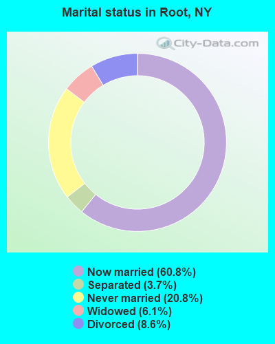
- Never married: 20.8%
- Now married: 60.8%
- Separated: 3.7%
- Widowed: 6.1%
- Divorced: 8.6%
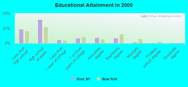
For population 25 years and over in Root:
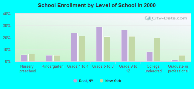
- High school or higher: 76.3%
- Bachelor's degree or higher: 12.2%
- Graduate or professional degree: 3.3%
- Unemployed: 5.4%
- Mean travel time to work (commute): 27.9 minutes
| Here: | 9.7 |
| New York average: | 14.2 |
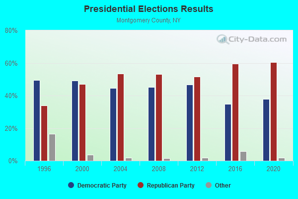
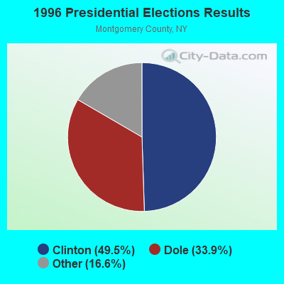
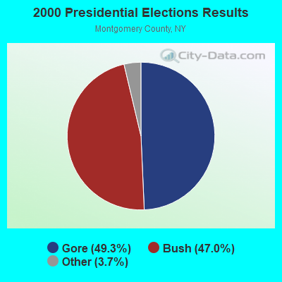
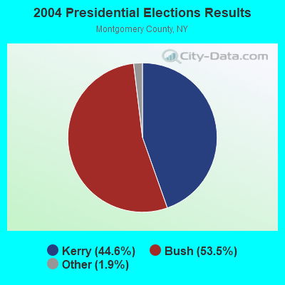
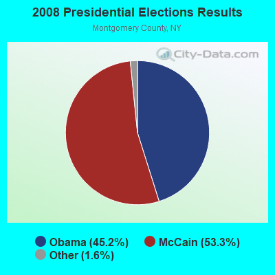
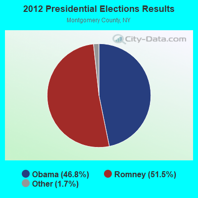
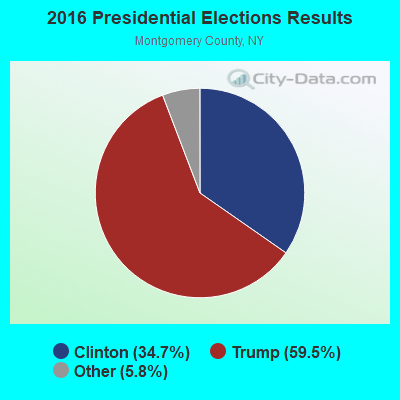
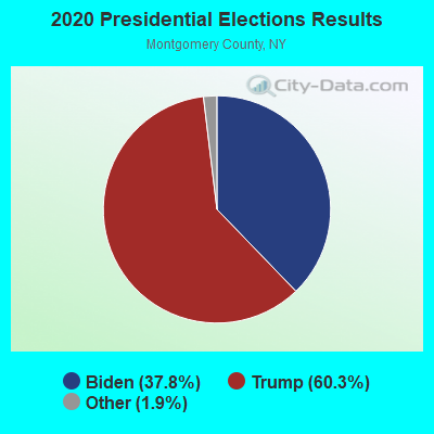
Graphs represent county-level data. Detailed 2008 Election Results
Religion statistics for Root, NY (based on Montgomery County data)
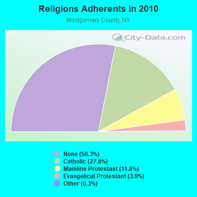

| Religion | Adherents | Congregations |
|---|---|---|
| Catholic | 13,946 | 12 |
| Mainline Protestant | 5,905 | 36 |
| Evangelical Protestant | 1,954 | 20 |
| Other | 137 | 5 |
| None | 28,277 | - |
Food Environment Statistics:
| Montgomery County: | 3.08 / 10,000 pop. |
| State: | 4.13 / 10,000 pop. |
| Montgomery County: | 0.41 / 10,000 pop. |
| New York: | 0.92 / 10,000 pop. |
| Here: | 4.93 / 10,000 pop. |
| State: | 1.68 / 10,000 pop. |
| This county: | 8.43 / 10,000 pop. |
| New York: | 8.82 / 10,000 pop. |
| Montgomery County: | 8.9% |
| State: | 8.2% |
| Montgomery County: | 29.1% |
| New York: | 23.8% |
| Montgomery County: | 13.8% |
| State: | 15.6% |
Strongest AM radio stations in Root:
- WGY (810 AM; 50 kW; SCHENECTADY, NY; Owner: CLEAR CHANNEL BROADCASTING LICENSES, INC.)
- WPTR (1540 AM; 50 kW; ALBANY, NY; Owner: KIMTRON, INC.)
- WNNZ (640 AM; 50 kW; WESTFIELD, MA; Owner: CLEAR CHANNEL BROADCASTING LICENSES, INC.)
- WIZR (930 AM; 1 kW; JOHNSTOWN, NY; Owner: 6 JOHNSON ROAD LICENSES, INC.)
- WXBH (1190 AM; 1 kW; COBLESKILL, NY; Owner: NY COMMUNICATIONS, LLC)
- WROW (590 AM; 5 kW; ALBANY, NY; Owner: 6 JOHNSON ROAD LICENSES, INC.)
- WOFX (980 AM; 5 kW; TROY, NY)
- WENT (1340 AM; 1 kW; GLOVERSVILLE, NY; Owner: WHITNEY RADIO BROADCASTING, INC.)
- WMCA (570 AM; 50 kW; NEW YORK, NY; Owner: SALEM MEDIA OF NEW YORK, LLC)
- WTIC (1080 AM; 50 kW; HARTFORD, CT; Owner: INFINITY RADIO OPERATIONS INC.)
- WFAN (660 AM; 50 kW; NEW YORK, NY; Owner: INFINITY BROADCASTING OPERATIONS, INC.)
- WBUG (1570 AM; 1 kW; AMSTERDAM, NY; Owner: ROSER COMMUNICATIONS NETWORK, INC.)
- WABC (770 AM; 50 kW; NEW YORK, NY; Owner: WABC-AM RADIO, INC.)
Strongest FM radio stations in Root:
- WJIV (101.9 FM; CHERRY VALLEY, NY; Owner: CHRISTIAN BROADCASTING SYSTEM, LTD.)
- WBUG-FM (101.1 FM; FORT PLAIN, NY; Owner: ROSER COMMUNICATIONS NETWORK, INC.)
- WQBJ (103.5 FM; COBLESKILL, NY; Owner: REGENT LICENSEE OF MANSFIELD, INC.)
- WCAN (93.3 FM; CANAJOHARIE, NY; Owner: W A M C)
- WMYY (97.3 FM; SCHOHARIE, NY; Owner: CAPITAL MEDIA CORPORATION)
- WGKR (105.3 FM; GRAND GORGE, NY; Owner: SOUND OF LIFE, INC.)
- WBKK (97.7 FM; AMSTERDAM, NY; Owner: GEM ASSOCIATES, L. P.)
- WAJZ (96.3 FM; VOORHEESVILLE, NY; Owner: 6 JOHNSON ROAD LICENSES, INC.)
- WZMR (104.9 FM; ALTAMONT, NY; Owner: 6 JOHNSON ROAD LICENSES, INC.)
- WYJB (95.5 FM; ALBANY, NY; Owner: 6 JOHNSON ROAD LICENSES, INC.)
- WPGL (90.7 FM; PATTERSONVILLE, NY; Owner: SOUND OF LIFE, INC.)
- WGNA-FM (107.7 FM; ALBANY, NY; Owner: REGENT LICENSEE OF MANSFIELD, INC.)
- WMHT-FM (89.1 FM; SCHENECTADY, NY; Owner: WMHT EDUCATIONAL TELECOMMUNICATIONS)
- WRVE (99.5 FM; SCHENECTADY, NY; Owner: CLEAR CHANNEL BROADCASTING LICENSES, INC.)
- WPYX (106.5 FM; ALBANY, NY; Owner: CAPSTAR TX LIMITED PARTNERSHIP)
- WVCR-FM (88.3 FM; LOUDONVILLE, NY; Owner: SIENA COLLEGE)
- WFLY (92.3 FM; TROY, NY; Owner: 6 JOHNSON ROAD LICENSES, INC.)
- WXLG (89.9 FM; NORTH CREEK, NY; Owner: THE ST. LAWRENCE UNIVERSITY)
- WSKU (105.5 FM; LITTLE FALLS, NY; Owner: CLEAR CHANNEL BROADCASTING LICENSES, INC.)
- WRIP (97.9 FM; WINDHAM, NY; Owner: RIP RADIO, LLC)
TV broadcast stations around Root:
- WYPX (Channel 55; AMSTERDAM, NY; Owner: PAXSON ALBANY LICENSE, INC.)
- WKTV (Channel 2; UTICA, NY; Owner: SMITH TELEVISION OF NEW YORK LICENSE HOLDINGS, INC.)
- WNYT (Channel 13; ALBANY, NY; Owner: WNYT-TV, LLC)
- WEWB-TV (Channel 45; SCHENECTADY, NY; Owner: WEWB, L.L.C.)
- WRGB (Channel 6; SCHENECTADY, NY; Owner: FREEDOM BROADCASTING OF NEW YORK, INC)
- WMHT (Channel 17; SCHENECTADY, NY; Owner: WMHT EDUCATIONAL TELECOMMUNICATIONS)
- WTEN (Channel 10; ALBANY, NY; Owner: YOUNG BROADCASTING OF ALBANY, INC.)
- WXXA-TV (Channel 23; ALBANY, NY; Owner: CLEAR CHANNEL BROADCASTING LICENSES, INC.)
- WFNY-CA (Channel 49; GLOVERSVILLE, NY; Owner: MICHAEL A. SLEEZER)
- National Bridge Inventory (NBI) Statistics
- 22Number of bridges
- 190ft / 57.7mTotal length
- $30,557,000Total costs
- 75,360Total average daily traffic
- 19,816Total average daily truck traffic
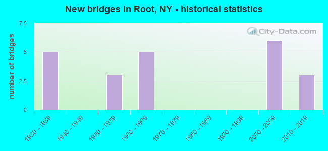
- New bridges - historical statistics
- 51930-1939
- 31950-1959
- 51960-1969
- 62000-2009
- 32010-2019
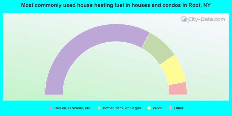
- 65.9%Fuel oil, kerosene, etc.
- 15.0%Bottled, tank, or LP gas
- 13.2%Wood
- 3.5%Electricity
- 1.0%Other fuel
- 0.7%Coal or coke
- 0.3%Utility gas
- 0.3%No fuel used
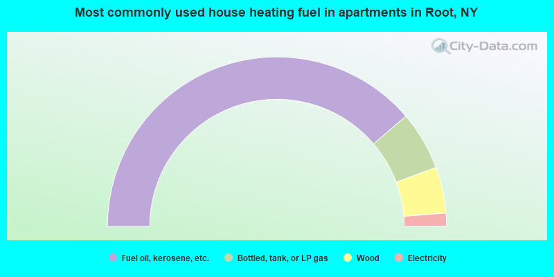
- 77.5%Fuel oil, kerosene, etc.
- 11.2%Bottled, tank, or LP gas
- 8.8%Wood
- 2.5%Electricity
Root compared to New York state average:
- Median house value significantly below state average.
- Unemployed percentage below state average.
- Black race population percentage significantly below state average.
- Hispanic race population percentage significantly below state average.
- Foreign-born population percentage significantly below state average.
- Renting percentage significantly below state average.
- Length of stay since moving in significantly above state average.
- Number of rooms per house significantly below state average.
- House age significantly below state average.
- Number of college students below state average.
- Percentage of population with a bachelor's degree or higher significantly below state average.