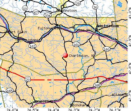
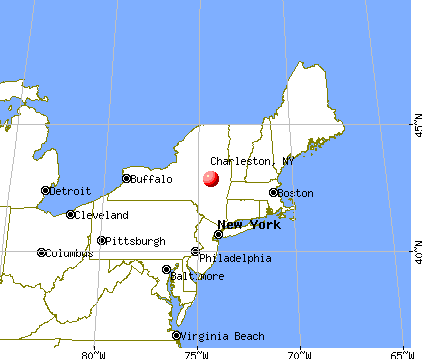
Charleston, New York
Submit your own pictures of this town and show them to the world
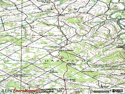
- OSM Map
- General Map
- Google Map
- MSN Map
Population change since 2000: +6.3%
 |
| Males: 696 | |
| Females: 677 |
| Median resident age: | 41.0 years |
| New York median age: | 40.7 years |
Zip codes: 12066.
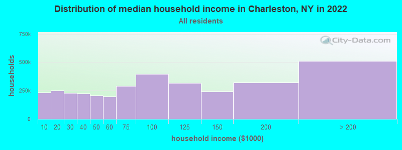
| Charleston: | $67,318 |
| NY: | $79,557 |
Estimated per capita income in 2022: $29,787 (it was $16,818 in 2000)
Charleston town income, earnings, and wages data
Estimated median house or condo value in 2022: $155,717 (it was $72,600 in 2000)
| Charleston: | $155,717 |
| NY: | $400,400 |
Mean prices in 2022: all housing units: $164,637; detached houses: $181,852; townhouses or other attached units: $164,701; in 2-unit structures: $120,098; in 3-to-4-unit structures: $151,547; in 5-or-more-unit structures: $210,099; mobile homes: $71,715
Detailed information about poverty and poor residents in Charleston, NY
Compare current foreclosures near Charleston, NY:
| Photo | Address | Area | Beds / Baths | Price | Details |
|---|---|---|---|---|---|

|
#1
Lansing Rd
Fultonville, NY 12072
|
1,248 sq. feet
|
2 baths 3 beds |
$204,500
|
show details |

|
#2
Lincoln St
Gloversville, NY 12078
|
2,600 sq. feet
|
3 baths 6 beds |
$29,900
|
show details |

|
#3
Prospect Ave
Gloversville, NY 12078
|
2,078 sq. feet
|
2 baths 2 beds |
show details | |

|
#4
Heagle Rd
Johnstown, NY 12095
|
1,710 sq. feet
|
1 baths 3 beds |
show details | |

|
#5
Valleyview Dr
Fultonville, NY 12072
|
1,618 sq. feet
|
2 baths 3 beds |
show details | |

|
#6
Latimer Hill Rd
Canajoharie, NY 13317
|
1,890 sq. feet
|
2 baths 4 beds |
show details | |

|
#7
Temple St
Gloversville, NY 12078
|
1,824 sq. feet
|
1 baths 3 beds |
show details | |

|
#8
Scribner Ave
Middleburgh, NY 12122
|
1,533 sq. feet
|
2 baths 2 beds |
show details | |

|
#9
Sprakers Hill Rd
Sprakers, NY 12166
|
1,836 sq. feet
|
1 baths 4 beds |
show details | |

|
#10
S Perry St
Johnstown, NY 12095
|
2,184 sq. feet
|
1 baths 4 beds |
show details |
| Photo | Address | Area | Beds / Baths | Price | Details |
|---|---|---|---|---|---|

|
#11
S Market St
Johnstown, NY 12095
|
1,360 sq. feet
|
2 baths 2 beds |
show details | |

|
#12
Montgomery St
Canajoharie, NY 13317
|
3,691 sq. feet
|
3 baths 4 beds |
show details | |

|
#13
Orchard St
Canajoharie, NY 13317
|
2,032 sq. feet
|
1 baths 3 beds |
show details | |

|
#14
Budnick Rd
Fort Plain, NY 13339
|
1,008 sq. feet
|
1 baths 2 beds |
show details | |

|
#15
W Main St
Johnstown, NY 12095
|
1,200 sq. feet
|
1 baths 2 beds |
show details | |

|
#16
Hamilton St
Johnstown, NY 12095
|
1,692 sq. feet
|
1 baths 3 beds |
show details | |

|
#17
Finlay St # 2
Amsterdam, NY 12010
|
2,367 sq. feet
|
2 baths 4 beds |
show details | |

|
#18
W Madison Ave
Johnstown, NY 12095
|
1,232 sq. feet
|
1 baths 3 beds |
show details | |

|
#19
Montgomery St
Canajoharie, NY 13317
|
2,172 sq. feet
|
2 baths 3 beds |
show details | |

|
#20
State Highway 67
Amsterdam, NY 12010
|
1,120 sq. feet
|
1 baths 3 beds |
show details |
| Photo | Address | Area | Beds / Baths | Price | Details |
|---|---|---|---|---|---|

|
#21
Walnut St
Canajoharie, NY 13317
|
2,079 sq. feet
|
1 baths 3 beds |
show details | |

|
#22
Township Rd
Altamont, NY 12009
|
1,564 sq. feet
|
2 baths 4 beds |
show details | |

|
#23
Locust Ave # 1
Amsterdam, NY 12010
|
2,496 sq. feet
|
2 baths 6 beds |
show details | |

|
#24
Sloane Ave
Amsterdam, NY 12010
|
1,248 sq. feet
|
1 baths 2 beds |
show details | |

|
#25
Church St
Amsterdam, NY 12010
|
2,005 sq. feet
|
2 baths 4 beds |
show details | |

|
#26
Evelyn Ave
Amsterdam, NY 12010
|
768 sq. feet
|
1 baths 1 beds |
show details | |

|
#27
Coolidge Rd
Amsterdam, NY 12010
|
1,562 sq. feet
|
1 baths 3 beds |
show details | |

|
#28
Church St
Amsterdam, NY 12010
|
1,192 sq. feet
|
1 baths 3 beds |
show details | |

|
#29
Mcclellan Ave
Amsterdam, NY 12010
|
2,688 sq. feet
|
2 baths 6 beds |
show details | |

|
#30
E Main St
Johnstown, NY 12095
|
1,500 sq. feet
|
1 baths 3 beds |
show details |
| Photo | Address | Area | Beds / Baths | Price | Details |
|---|---|---|---|---|---|

|
#31
1/2 Burton St
Johnstown, NY 12095
|
1,760 sq. feet
|
2 baths 4 beds |
show details | |

|
#32
Burton St
Johnstown, NY 12095
|
1,708 sq. feet
|
1 baths 1 beds |
show details | |

|
#33
State Highway 10
Fort Plain, NY 13339
|
1,848 sq. feet
|
1 baths 3 beds |
show details | |

|
#34
Voorhees Rd
Amsterdam, NY 12010
|
1,500 sq. feet
|
1 baths 3 beds |
show details | |

|
#35
Cliff St
Middleburgh, NY 12122
|
1,400 sq. feet
|
1 baths 3 beds |
show details | |

|
#36
Reidel Rd
Amsterdam, NY 12010
|
1,056 sq. feet
|
1 baths 3 beds |
show details | |

|
#37
Johnson Ave Ext
Gloversville, NY 12078
|
1,056 sq. feet
|
1 baths 3 beds |
show details | |

|
#38
Bloomingdale Ave
Gloversville, NY 12078
|
1,189 sq. feet
|
2 baths 3 beds |
show details | |

|
#39
Voorhees Rd
Amsterdam, NY 12010
|
900 sq. feet
|
1 baths 3 beds |
show details | |

|
#40
Beech St
Gloversville, NY 12078
|
904 sq. feet
|
1 baths 2 beds |
show details |
| Photo | Address | Area | Beds / Baths | Price | Details |
|---|---|---|---|---|---|

|
#41
Chestnut St
Sharon Springs, NY 13459
|
1,843 sq. feet
|
1 baths 3 beds |
show details | |

|
#42
Della Valle Dr
Amsterdam, NY 12010
|
1,242 sq. feet
|
2 baths 3 beds |
show details | |

|
#43
County Highway 107
Fort Johnson, NY 12070
|
2,478 sq. feet
|
1 baths 3 beds |
show details | |

|
#44
Wells St
Johnstown, NY 12095
|
1,175 sq. feet
|
1 baths 2 beds |
show details | |

|
#45
Lexington Ave # 2
Gloversville, NY 12078
|
3,096 sq. feet
|
2 baths 5 beds |
show details | |

|
#46
Upper Gregg Rd
Schenectady, NY 12306
|
976 sq. feet
|
1 baths 2 beds |
show details | |

|
#47
W Richmondville Rd
Cobleskill, NY 12043
|
1,125 sq. feet
|
1 baths 3 beds |
show details | |

|
#48
Midline Rd
Amsterdam, NY 12010
|
1,248 sq. feet
|
1 baths 2 beds |
show details | |

|
#49
S Judson St
Gloversville, NY 12078
|
1,458 sq. feet
|
1 baths 3 beds |
show details | |

|
Check over 1 million property listings on Foreclosure.com!
|
browse all offers | |||

- 1,31996.1%White alone
- 251.8%Hispanic
- 120.9%Two or more races
- 100.7%Asian alone
- 50.4%Black alone
- 10.07%American Indian alone
- 10.07%Native Hawaiian and Other
Pacific Islander alone
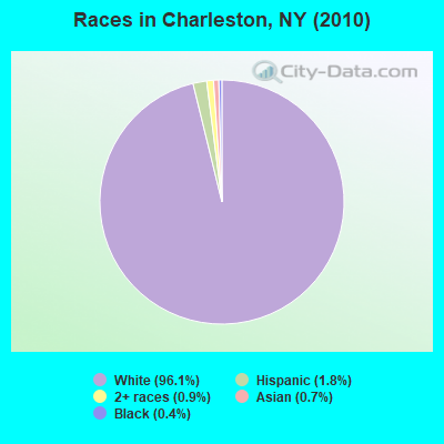
Races in Charleston detailed stats: ancestries, foreign born residents, place of birth
 Recent articles from our blog. Our writers, many of them Ph.D. graduates or candidates, create easy-to-read articles on a wide variety of topics.

 | smaller Upstate NY cities and towns/African American communities (5974 replies) |
| NYC considers reparations for black residents (222 replies) |
| Safest Cities from natural disasters (70 replies) |
| Syracuse, NY Highly Rated and Ranked (43 replies) |
| I moved from WP to Charleston SC 6 years ago (2 replies) |
| Why are Upstate NY Houses So Cheap?? (46 replies) |
Latest news from Charleston, NY collected exclusively by city-data.com from local newspapers, TV, and radio stations
Ancestries: German (25.2%), Irish (14.9%), Italian (12.7%), United States (9.4%), English (8.8%), Dutch (7.2%).
Current Local Time: EST time zone
Land area: 42.6 square miles.
Population density: 32 people per square mile (very low).
11 residents are foreign born
| This town: | 0.9% |
| New York: | 20.4% |
| Charleston town: | 2.5% ($1,837) |
| New York: | 1.9% ($2,847) |
Nearest city with pop. 50,000+: Schenectady, NY  (21.0 miles , pop. 61,821).
Nearest city with pop. 200,000+: Bronx, NY (138.3 miles , pop. 1,332,650).
Nearest cities:
), ), ), ), ), ), Latitude: 42.81 N, Longitude: 74.34 W
Area code commonly used in this area: 518
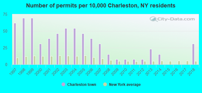
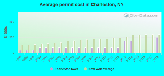
Single-family new house construction building permits:
- 2018: 4 buildings, average cost: $249,800
- 2014: 2 buildings, average cost: $187,500
- 2013: 3 buildings, average cost: $193,300
- 2012: 1 building, cost: $87,500
- 2011: 1 building, cost: $87,500
- 2010: 1 building, cost: $87,500
- 2009: 1 building, cost: $87,500
- 2008: 2 buildings, average cost: $87,500
- 2007: 4 buildings, average cost: $87,500
- 2006: 5 buildings, average cost: $87,500
- 2005: 6 buildings, average cost: $87,500
- 2004: 7 buildings, average cost: $87,500
- 2003: 7 buildings, average cost: $87,500
- 2002: 6 buildings, average cost: $87,500
- 2001: 5 buildings, average cost: $87,500
- 2000: 4 buildings, average cost: $87,500
- 1999: 9 buildings, average cost: $41,000
- 1998: 9 buildings, average cost: $41,000
- 1997: 8 buildings, average cost: $41,000
| Here: | 5.1% |
| New York: | 4.4% |
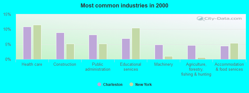
- Health care (10.9%)
- Construction (8.9%)
- Public administration (8.2%)
- Educational services (7.0%)
- Machinery (4.8%)
- Agriculture, forestry, fishing & hunting (4.6%)
- Accommodation & food services (4.5%)
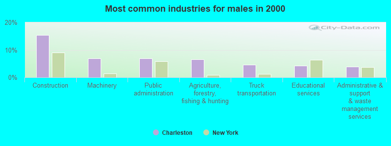
- Construction (15.4%)
- Machinery (6.9%)
- Public administration (6.9%)
- Agriculture, forestry, fishing & hunting (6.6%)
- Truck transportation (4.6%)
- Educational services (4.3%)
- Administrative & support & waste management services (3.9%)
- Health care (22.7%)
- Educational services (10.2%)
- Public administration (9.8%)
- Finance & insurance (6.3%)
- Department & other general merchandise stores (5.1%)
- Food & beverage stores (5.1%)
- Accommodation & food services (5.1%)
- Driver/sales workers and truck drivers (7.9%)
- Other production occupations, including supervisors (5.7%)
- Other office and administrative support workers, including supervisors (5.5%)
- Building and grounds cleaning and maintenance occupations (5.2%)
- Registered nurses (3.9%)
- Other management occupations, except farmers and farm managers (3.6%)
- Secretaries and administrative assistants (2.9%)
- Driver/sales workers and truck drivers (14.4%)
- Other production occupations, including supervisors (8.5%)
- Building and grounds cleaning and maintenance occupations (7.9%)
- Vehicle and mobile equipment mechanics, installers, and repairers (4.9%)
- Electrical equipment mechanics and other installation, maintenance, and repair workers, including supervisors (4.6%)
- Agricultural workers, including supervisors (4.3%)
- Other management occupations, except farmers and farm managers (3.9%)
- Other office and administrative support workers, including supervisors (10.6%)
- Registered nurses (8.2%)
- Secretaries and administrative assistants (5.5%)
- Nursing, psychiatric, and home health aides (5.5%)
- Other sales and related occupations, including supervisors (4.7%)
- Other teachers, instructors, education, training, and library occupations (4.3%)
- Other management occupations, except farmers and farm managers (3.1%)
Average climate in Charleston, New York
Based on data reported by over 4,000 weather stations


(lower is better)
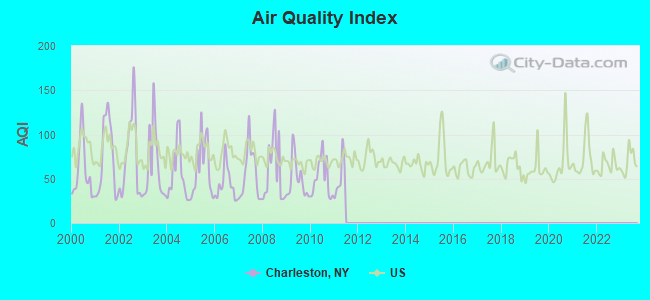
Air Quality Index (AQI) level in 2010 was 50.7. This is significantly better than average.
| City: | 50.7 |
| U.S.: | 72.6 |
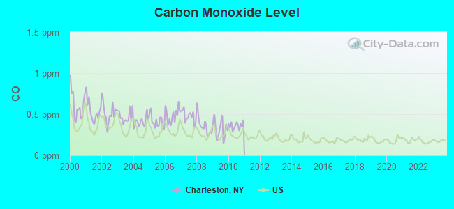
Carbon Monoxide (CO) [ppm] level in 2010 was 0.362. This is significantly worse than average. Closest monitor was 20.6 miles away from the city center.
| City: | 0.362 |
| U.S.: | 0.251 |
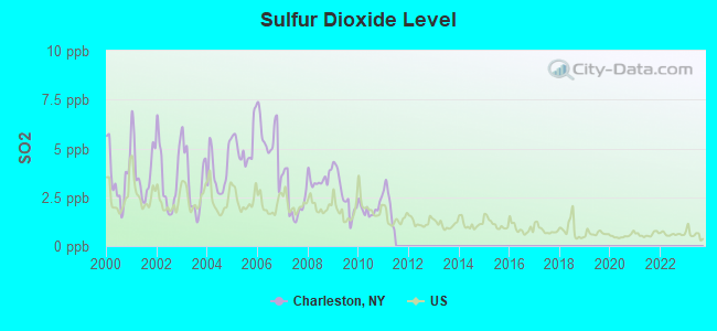
Sulfur Dioxide (SO2) [ppb] level in 2010 was 1.92. This is worse than average. Closest monitor was 16.4 miles away from the city center.
| City: | 1.92 |
| U.S.: | 1.51 |
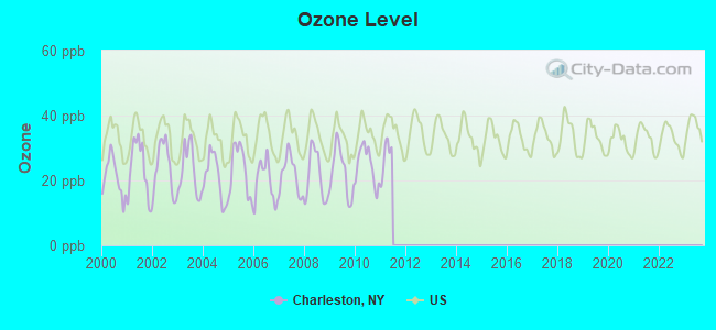
Ozone [ppb] level in 2010 was 24.8. This is better than average. Closest monitor was 20.6 miles away from the city center.
| City: | 24.8 |
| U.S.: | 33.3 |
Tornado activity:
Charleston-area historical tornado activity is near New York state average. It is 61% smaller than the overall U.S. average.
On 7/10/1989, a category F4 (max. wind speeds 207-260 mph) tornado 9.5 miles away from the Charleston town center injured 20 people and caused between $5,000,000 and $50,000,000 in damages.
On 6/24/1960, a category F3 (max. wind speeds 158-206 mph) tornado 23.6 miles away from the town center injured 9 people and caused between $5,000,000 and $50,000,000 in damages.
Earthquake activity:
Charleston-area historical earthquake activity is significantly above New York state average. It is 67% smaller than the overall U.S. average.On 10/7/1983 at 10:18:46, a magnitude 5.3 (5.1 MB, 5.3 LG, 5.1 ML, Class: Moderate, Intensity: VI - VII) earthquake occurred 78.7 miles away from the city center
On 4/20/2002 at 10:50:47, a magnitude 5.3 (5.3 ML, Depth: 3.0 mi) earthquake occurred 121.8 miles away from the city center
On 4/20/2002 at 10:50:47, a magnitude 5.2 (5.2 MB, 4.2 MS, 5.2 MW, 5.0 MW) earthquake occurred 119.8 miles away from the city center
On 1/19/1982 at 00:14:42, a magnitude 4.7 (4.5 MB, 4.7 MD, 4.5 LG, Class: Light, Intensity: IV - V) earthquake occurred 146.3 miles away from the city center
On 6/17/1991 at 08:53:16, a magnitude 4.1 (4.0 MB, 4.0 LG, Depth: 3.1 mi) earthquake occurred 21.2 miles away from the city center
On 8/23/2011 at 17:51:04, a magnitude 5.8 (5.8 MW, Depth: 3.7 mi) earthquake occurred 388.4 miles away from Charleston center
Magnitude types: regional Lg-wave magnitude (LG), body-wave magnitude (MB), duration magnitude (MD), local magnitude (ML), surface-wave magnitude (MS), moment magnitude (MW)
Natural disasters:
The number of natural disasters in Montgomery County (22) is greater than the US average (15).Major Disasters (Presidential) Declared: 13
Emergencies Declared: 7
Causes of natural disasters: Floods: 10, Storms: 10, Hurricanes: 3, Snowstorms: 2, Tropical Storms: 2, Blizzard: 1, Power Outage: 1, Tornado: 1, Wind: 1, Winter Storm: 1, Other: 2 (Note: some incidents may be assigned to more than one category).
Hospitals and medical centers near Charleston:
- RIVER RIDGE LIVING CENTER L L C (Nursing Home, about 11 miles away; AMSTERDAM, NY)
- EDEN PARK HEALTH CARE CENTRE INC COBLESKILL (Nursing Home, about 12 miles away; COBLESKILL, NY)
- ST MARY'S HOSPITAL AT AMSTERDAM Acute Care Hospitals (about 12 miles away; AMSTERDAM, NY)
- COBLESKILL REGIONAL HOSPITAL Acute Care Hospitals (about 13 miles away; COBLESKILL, NY)
- JOHNSTOWN HOSPITAL (Hospital, about 13 miles away; JOHNSTOWN, NY)
- WELLS NURSING HOME INC (Nursing Home, about 14 miles away; JOHNSTOWN, NY)
- MT LORETTO NURSING HOME INC (Nursing Home, about 14 miles away; AMSTERDAM, NY)
Airports located in Charleston:
- The Ranch Airport (3NY0) (Runways: 1)
Colleges/universities with over 2000 students nearest to Charleston:
- Fulton-Montgomery Community College (about 12 miles; Johnstown, NY; Full-time enrollment: 2,043)
- SUNY College of Agriculture and Technology at Cobleskill (about 14 miles; Cobleskill, NY; FT enrollment: 2,455)
- Schenectady County Community College (about 21 miles; Schenectady, NY; FT enrollment: 3,676)
- Union College (about 22 miles; Schenectady, NY; FT enrollment: 2,075)
- Excelsior College (about 26 miles; Albany, NY; FT enrollment: 4,723)
- SUNY at Albany (about 28 miles; Albany, NY; FT enrollment: 15,490)
- The College of Saint Rose (about 31 miles; Albany, NY; FT enrollment: 4,085)
Points of interest:
Notable locations in Charleston: Fox Corners (A), Lib Corners (B), Market Corners (C), Davis Corners (D), Rockwell Corners (E), Charleston Volunteer Fire Department (F). Display/hide their locations on the map
Church in Charleston: Christian Church (A). Display/hide its location on the map
Cemeteries: Friends Cemetery (1), First Baptist Church Cemetery (2), Christian Church Cemetery (3), Kimball Cemetery (4). Display/hide their locations on the map
Creeks: Wilsey Creek (A), Bowman Creek (B). Display/hide their locations on the map
Birthplace of: Ira Harris - Politician.
| This town: | 2.6 people |
| New York: | 2.6 people |
| This town: | 70.6% |
| Whole state: | 63.5% |
| This town: | 11.3% |
| Whole state: | 6.8% |
Likely homosexual households (counted as self-reported same-sex unmarried-partner households)
- Lesbian couples: 0.4% of all households
- Gay men: 0.4% of all households
| This town: | 10.1% |
| Whole state: | 14.6% |
| This town: | 4.7% |
| Whole state: | 7.4% |
For population 15 years and over in Charleston:
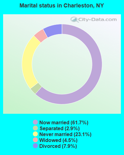
- Never married: 23.1%
- Now married: 61.7%
- Separated: 2.9%
- Widowed: 4.5%
- Divorced: 7.9%
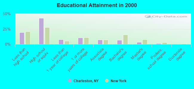
For population 25 years and over in Charleston:
- High school or higher: 80.4%
- Bachelor's degree or higher: 12.1%
- Graduate or professional degree: 5.3%
- Unemployed: 7.7%
- Mean travel time to work (commute): 36.7 minutes
| Here: | 9.5 |
| New York average: | 14.2 |
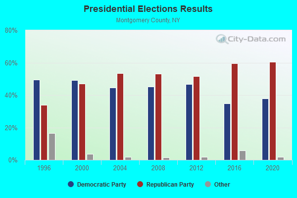
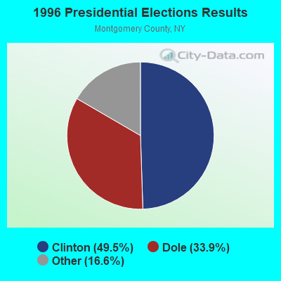
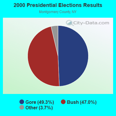
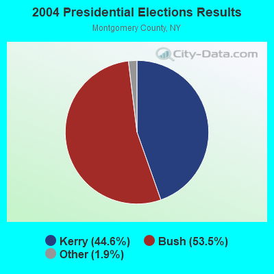
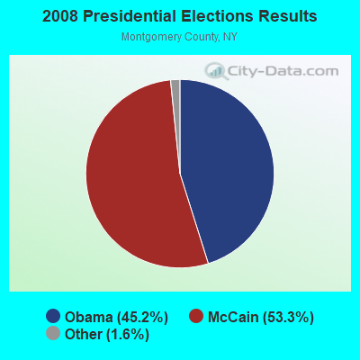
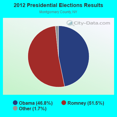
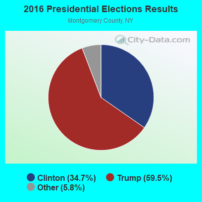
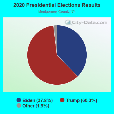
Graphs represent county-level data. Detailed 2008 Election Results
Religion statistics for Charleston, NY (based on Montgomery County data)
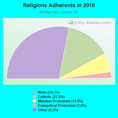

| Religion | Adherents | Congregations |
|---|---|---|
| Catholic | 13,946 | 12 |
| Mainline Protestant | 5,905 | 36 |
| Evangelical Protestant | 1,954 | 20 |
| Other | 137 | 5 |
| None | 28,277 | - |
Food Environment Statistics:
| Montgomery County: | 3.08 / 10,000 pop. |
| New York: | 4.13 / 10,000 pop. |
| Montgomery County: | 0.41 / 10,000 pop. |
| New York: | 0.92 / 10,000 pop. |
| This county: | 4.93 / 10,000 pop. |
| State: | 1.68 / 10,000 pop. |
| Montgomery County: | 8.43 / 10,000 pop. |
| State: | 8.82 / 10,000 pop. |
| Montgomery County: | 8.9% |
| New York: | 8.2% |
| Here: | 29.1% |
| New York: | 23.8% |
| Here: | 13.8% |
| State: | 15.6% |
Strongest AM radio stations in Charleston:
- WGY (810 AM; 50 kW; SCHENECTADY, NY; Owner: CLEAR CHANNEL BROADCASTING LICENSES, INC.)
- WPTR (1540 AM; 50 kW; ALBANY, NY; Owner: KIMTRON, INC.)
- WNNZ (640 AM; 50 kW; WESTFIELD, MA; Owner: CLEAR CHANNEL BROADCASTING LICENSES, INC.)
- WXBH (1190 AM; 1 kW; COBLESKILL, NY; Owner: NY COMMUNICATIONS, LLC)
- WBUG (1570 AM; 1 kW; AMSTERDAM, NY; Owner: ROSER COMMUNICATIONS NETWORK, INC.)
- WOFX (980 AM; 5 kW; TROY, NY)
- WROW (590 AM; 5 kW; ALBANY, NY; Owner: 6 JOHNSON ROAD LICENSES, INC.)
- WIZR (930 AM; 1 kW; JOHNSTOWN, NY; Owner: 6 JOHNSON ROAD LICENSES, INC.)
- WTIC (1080 AM; 50 kW; HARTFORD, CT; Owner: INFINITY RADIO OPERATIONS INC.)
- WMCA (570 AM; 50 kW; NEW YORK, NY; Owner: SALEM MEDIA OF NEW YORK, LLC)
- WCSS (1490 AM; 1 kW; AMSTERDAM, NY; Owner: WEBER COMM. OF AMSTERDAM, INC.)
- WABY (1160 AM; 5 kW; MECHANICVILLE, NY; Owner: ANASTOS MEDIA GROUP, INC.)
- WFAN (660 AM; 50 kW; NEW YORK, NY; Owner: INFINITY BROADCASTING OPERATIONS, INC.)
Strongest FM radio stations in Charleston:
- WMYY (97.3 FM; SCHOHARIE, NY; Owner: CAPITAL MEDIA CORPORATION)
- WJIV (101.9 FM; CHERRY VALLEY, NY; Owner: CHRISTIAN BROADCASTING SYSTEM, LTD.)
- WPGL (90.7 FM; PATTERSONVILLE, NY; Owner: SOUND OF LIFE, INC.)
- WAJZ (96.3 FM; VOORHEESVILLE, NY; Owner: 6 JOHNSON ROAD LICENSES, INC.)
- WBKK (97.7 FM; AMSTERDAM, NY; Owner: GEM ASSOCIATES, L. P.)
- WBUG-FM (101.1 FM; FORT PLAIN, NY; Owner: ROSER COMMUNICATIONS NETWORK, INC.)
- WZMR (104.9 FM; ALTAMONT, NY; Owner: 6 JOHNSON ROAD LICENSES, INC.)
- WYJB (95.5 FM; ALBANY, NY; Owner: 6 JOHNSON ROAD LICENSES, INC.)
- WGNA-FM (107.7 FM; ALBANY, NY; Owner: REGENT LICENSEE OF MANSFIELD, INC.)
- WMHT-FM (89.1 FM; SCHENECTADY, NY; Owner: WMHT EDUCATIONAL TELECOMMUNICATIONS)
- WQBJ (103.5 FM; COBLESKILL, NY; Owner: REGENT LICENSEE OF MANSFIELD, INC.)
- WRVE (99.5 FM; SCHENECTADY, NY; Owner: CLEAR CHANNEL BROADCASTING LICENSES, INC.)
- WPYX (106.5 FM; ALBANY, NY; Owner: CAPSTAR TX LIMITED PARTNERSHIP)
- WVCR-FM (88.3 FM; LOUDONVILLE, NY; Owner: SIENA COLLEGE)
- WFLY (92.3 FM; TROY, NY; Owner: 6 JOHNSON ROAD LICENSES, INC.)
- WGKR (105.3 FM; GRAND GORGE, NY; Owner: SOUND OF LIFE, INC.)
- WEQX (102.7 FM; MANCHESTER, VT; Owner: NORTHSHIRE COMMUNICATIONS, INC.)
- WTRY-FM (98.3 FM; ROTTERDAM, NY; Owner: CAPSTAR TX LIMITED PARTNERSHIP)
- WJAN (95.1 FM; SUNDERLAND, VT; Owner: 6 JOHNSON ROAD LICENSES, INC.)
- WRIP (97.9 FM; WINDHAM, NY; Owner: RIP RADIO, LLC)
TV broadcast stations around Charleston:
- WYPX (Channel 55; AMSTERDAM, NY; Owner: PAXSON ALBANY LICENSE, INC.)
- WKTV (Channel 2; UTICA, NY; Owner: SMITH TELEVISION OF NEW YORK LICENSE HOLDINGS, INC.)
- WNYT (Channel 13; ALBANY, NY; Owner: WNYT-TV, LLC)
- WEWB-TV (Channel 45; SCHENECTADY, NY; Owner: WEWB, L.L.C.)
- WRGB (Channel 6; SCHENECTADY, NY; Owner: FREEDOM BROADCASTING OF NEW YORK, INC)
- WMHT (Channel 17; SCHENECTADY, NY; Owner: WMHT EDUCATIONAL TELECOMMUNICATIONS)
- WTEN (Channel 10; ALBANY, NY; Owner: YOUNG BROADCASTING OF ALBANY, INC.)
- WXXA-TV (Channel 23; ALBANY, NY; Owner: CLEAR CHANNEL BROADCASTING LICENSES, INC.)
- National Bridge Inventory (NBI) Statistics
- 5Number of bridges
- 36ft / 11.1mTotal length
- $4,136,000Total costs
- 1,027Total average daily traffic
- 29Total average daily truck traffic
- 1,437Total future (year 2037) average daily traffic
FCC Registered Broadcast Land Mobile Towers:
1- Oak Ridge Down Link (Lat: 42.790083 Lon: -74.322639), Call Sign: WJK51,
Assigned Frequencies: 72.2200 MHz, Grant Date: 11/15/2022, Expiration Date: 02/11/2033, Registrant: New York State Department Of Transportation, 50 Wolf Road Pod 5-3, Albany, NY 12232, Phone: (518) 457-1584, Email:
FCC Registered Paging Towers:
1- Oakridge, 4 Miles Sw Of Charleston (Lat: 42.790333 Lon: -74.321778), Call Sign: KTS207,
Assigned Frequencies: 152.840 MHz, Grant Date: 06/24/2008, Expiration Date: 07/01/2018, Cancellation Date: 09/30/2011, Registrant: Blooston, Mordkofsky, Dickens, Duffy & Prendergast, LLP, 2120 L Street, Nw, Suite 300, Washington, DC 20037, Phone: (202) 659-0830, Fax: (202) 828-5568
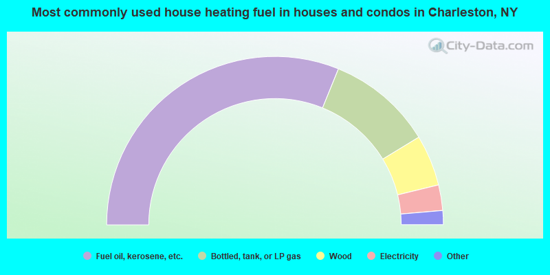
- 62.3%Fuel oil, kerosene, etc.
- 20.3%Bottled, tank, or LP gas
- 9.8%Wood
- 4.9%Electricity
- 1.5%Utility gas
- 0.7%Coal or coke
- 0.5%No fuel used
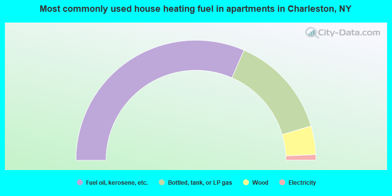
- 63.1%Fuel oil, kerosene, etc.
- 27.7%Bottled, tank, or LP gas
- 7.7%Wood
- 1.5%Electricity
Charleston compared to New York state average:
- Median house value significantly below state average.
- Unemployed percentage below state average.
- Black race population percentage significantly below state average.
- Hispanic race population percentage significantly below state average.
- Foreign-born population percentage significantly below state average.
- Renting percentage significantly below state average.
- Length of stay since moving in significantly above state average.
- Number of rooms per house significantly below state average.
- House age significantly below state average.
- Number of college students below state average.
- Percentage of population with a bachelor's degree or higher significantly below state average.