Rangeley, Maine
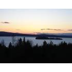
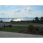
Rangeley: Rangeley overlook
Rangeley: Fall in Rangeley
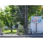
Rangeley: Sarges for lunch

Rangeley: Moose on the loose in Rangeley
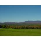
Rangeley: Dallas Hill in the Fall
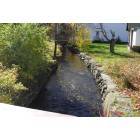
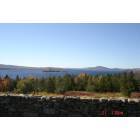
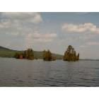
Rangeley: Rangeley Lake
Rangeley: Doc Grants
Rangeley: Rangeley Over look
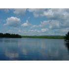
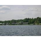
Rangeley: Rangeley Lake
Rangeley: Rangeley, Town and Lake Motel
Rangeley: Rangeley, Rangeley Lake
- see
18
more - add
your
Submit your own pictures of this town and show them to the world
- OSM Map
- General Map
- Google Map
- MSN Map
Population change since 2000: +11.0%
 |
| Males: 593 | |
| Females: 575 |
| Median resident age: | 51.4 years |
| Maine median age: | 43.0 years |
Zip codes: 04970.
| Rangeley: | $61,510 |
| ME: | $69,543 |
Estimated per capita income in 2022: $41,477 (it was $19,052 in 2000)
Rangeley town income, earnings, and wages data
Estimated median house or condo value in 2022: $304,706 (it was $114,800 in 2000)
| Rangeley: | $304,706 |
| ME: | $290,600 |
Mean prices in 2022: all housing units: $249,382; detached houses: $272,823; townhouses or other attached units: $269,365; in 2-unit structures: $215,792; in 3-to-4-unit structures: $159,774; in 5-or-more-unit structures: $237,338; mobile homes: $71,957
Detailed information about poverty and poor residents in Rangeley, ME
Compare current foreclosures near your location:
| Photo | Address | Area | Beds / Baths | Price | Details |
|---|---|---|---|---|---|

|
#1
Bayberry Cir
Columbus, OH 43207
|
1,564 sq. feet
|
1 baths 3 beds |
$127,500
|
show details |

|
#2
S High St
Columbus, OH 43207
|
1,678 sq. feet
|
2 baths 4 beds |
$31,900
|
show details |

|
#3
E 21st Ave
Columbus, OH 43211
|
1,061 sq. feet
|
1 baths 3 beds |
$179,900
|
show details |

|
#4
Marshrun Dr
Grove City, OH 43123
|
2,036 sq. feet
|
2 baths 4 beds |
show details | |

|
#5
E Howard Rd
Columbus, OH 43207
|
1,056 sq. feet
|
1 baths 3 beds |
show details | |

|
#6
Hiawatha Park Dr
Columbus, OH 43211
|
1,278 sq. feet
|
1 baths 4 beds |
show details | |

|
#7
Brookstone Dr
Westerville, OH 43082
|
1,783 sq. feet
|
3 baths 3 beds |
show details | |

|
#8
N Roys Ave
Columbus, OH 43204
|
1,248 sq. feet
|
2 baths 3 beds |
show details | |

|
#9
Summertree Ln
Westerville, OH 43081
|
2,496 sq. feet
|
2 baths 3 beds |
show details | |

|
#10
Mink St SW
Pataskala, OH 43062
|
1,442 sq. feet
|
1 baths 3 beds |
show details |
| Photo | Address | Area | Beds / Baths | Price | Details |
|---|---|---|---|---|---|

|
#11
Armada Rd
Columbus, OH 43232
|
1,028 sq. feet
|
1 baths 4 beds |
show details | |

|
#12
Midland Ave
Columbus, OH 43223
|
1,518 sq. feet
|
1 baths 2 beds |
show details | |

|
#13
Grasmere Ave
Columbus, OH 43211
|
720 sq. feet
|
1 baths 2 beds |
show details | |

|
#14
High Free Pike
West Jefferson, OH 43162
|
1,216 sq. feet
|
2 baths 4 beds |
show details | |

|
#15
Wrexham Ave
Columbus, OH 43223
|
1,235 sq. feet
|
1 baths 3 beds |
show details | |

|
#16
Meadowbrook Dr
Columbus, OH 43207
|
1,752 sq. feet
|
2 baths 4 beds |
show details | |

|
#17
Chidley St
Galloway, OH 43119
|
1,502 sq. feet
|
1 baths 3 beds |
show details | |

|
#18
Kingsglen Dr
Grove City, OH 43123
|
1,635 sq. feet
|
2 baths 4 beds |
show details | |

|
#19
Fergus Rd
Grove City, OH 43123
|
3,312 sq. feet
|
2 baths 4 beds |
show details | |

|
#20
S Hague Ave
Columbus, OH 43204
|
979 sq. feet
|
1 baths 2 beds |
show details |
| Photo | Address | Area | Beds / Baths | Price | Details |
|---|---|---|---|---|---|

|
#21
E Welch Ave
Columbus, OH 43207
|
1,864 sq. feet
|
2 baths 4 beds |
show details | |

|
#22
Striebel Ct
Columbus, OH 43227
|
925 sq. feet
|
1 baths 3 beds |
show details | |

|
#23
S Richardson Ave
Columbus, OH 43204
|
1,520 sq. feet
|
2 baths 3 beds |
show details | |

|
#24
Lehner Rd
Columbus, OH 43224
|
1,628 sq. feet
|
2 baths 4 beds |
show details | |

|
#25
Derrer Rd -872
Columbus, OH 43204
|
1,667 sq. feet
|
2 baths 5 beds |
show details | |

|
#26
Fahlander Dr N
Columbus, OH 43229
|
1,338 sq. feet
|
2 baths 3 beds |
show details | |

|
#27
Sleeping Meadow Dr
New Albany, OH 43054
|
3,211 sq. feet
|
2 baths 4 beds |
show details | |

|
#28
Gladys Rd
Columbus, OH 43228
|
832 sq. feet
|
1 baths 3 beds |
show details | |

|
#29
N 18th St
Columbus, OH 43203
|
1,690 sq. feet
|
1 baths 4 beds |
show details | |

|
#30
Chester Rd
Columbus, OH 43221
|
3,300 sq. feet
|
4 baths 5 beds |
show details |
| Photo | Address | Area | Beds / Baths | Price | Details |
|---|---|---|---|---|---|

|
#31
Glenmate Ct
Columbus, OH 43223
|
1,050 sq. feet
|
1 baths 3 beds |
show details | |

|
#32
Ashgrove Dr
Grove City, OH 43123
|
1,772 sq. feet
|
2 baths 4 beds |
show details | |

|
#33
Hildreth Ave
Columbus, OH 43203
|
1,798 sq. feet
|
2 baths 4 beds |
show details | |

|
#34
Fairfield Ave
Columbus, OH 43203
|
984 sq. feet
|
1 baths 2 beds |
show details | |

|
#35
London Groveport Rd
Grove City, OH 43123
|
816 sq. feet
|
1 baths 2 beds |
show details | |

|
#36
Stoneybrook Blvd # 21a
Hilliard, OH 43026
|
1,231 sq. feet
|
2 baths 3 beds |
show details | |

|
#37
Scottwood Rd
Columbus, OH 43227
|
1,008 sq. feet
|
1 baths 3 beds |
show details | |

|
#38
Stoneybrook B 21a
Hilliard, OH 43026
|
1,031 sq. feet
|
1 baths 3 beds |
show details | |

|
#39
Casa Blvd
Grove City, OH 43123
|
1,002 sq. feet
|
1 baths 2 beds |
show details | |

|
#40
Wesson Dr
Columbus, OH 43232
|
1,200 sq. feet
|
1 baths 3 beds |
show details |
| Photo | Address | Area | Beds / Baths | Price | Details |
|---|---|---|---|---|---|

|
#41
Southbend Dr
Canal Winchester, OH 43110
|
3,394 sq. feet
|
2 baths 3 beds |
show details | |

|
#42
Nantucket Ave
Columbus, OH 43235
|
1,864 sq. feet
|
2 baths 3 beds |
show details | |

|
#43
Illinois Ave
Westerville, OH 43081
|
1,120 sq. feet
|
1 baths 3 beds |
show details | |

|
#44
Tea Party Pl
Columbus, OH 43207
|
1,176 sq. feet
|
2 baths 3 beds |
show details | |

|
#45
Ridgebury Dr
Hilliard, OH 43026
|
832 sq. feet
|
1 baths 2 beds |
show details | |

|
#46
Renford Ct
Powell, OH 43065
|
1,795 sq. feet
|
1 baths 3 beds |
show details | |

|
#47
Ratify Blvd
Columbus, OH 43207
|
1,356 sq. feet
|
2 baths 3 beds |
show details | |

|
#48
Royal Farm E
Blacklick, OH 43004
|
2,425 sq. feet
|
2 baths 3 beds |
show details | |

|
#49
Mango Ln
Hilliard, OH 43026
|
1,024 sq. feet
|
1 baths 2 beds |
show details | |

|
Check over 1 million property listings on Foreclosure.com!
|
browse all offers | |||

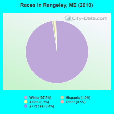
- 1,13997.5%White alone
- 121.0%Hispanic
- 60.5%Asian alone
- 60.5%Other race alone
- 50.4%Two or more races
Races in Rangeley detailed stats: ancestries, foreign born residents, place of birth
Type |
2009 |
2010 |
2011 |
2012 |
2013 |
2014 |
2015 |
2016 |
2017 |
2018 |
2019 |
2020 |
2021 |
2022 |
|---|---|---|---|---|---|---|---|---|---|---|---|---|---|---|
| Murders (per 100,000) | 0 (0.0) | 0 (0.0) | 0 (0.0) | 0 (0.0) | 0 (0.0) | 0 (0.0) | 0 (0.0) | 1 (87.0) | 0 (0.0) | 0 (0.0) | 0 (0.0) | 0 (0.0) | 0 (0.0) | 0 (0.0) |
| Rapes (per 100,000) | 1 (84.2) | 0 (0.0) | 0 (0.0) | 0 (0.0) | 0 (0.0) | 0 (0.0) | 0 (0.0) | 0 (0.0) | 0 (0.0) | 1 (87.0) | 0 (0.0) | 0 (0.0) | 0 (0.0) | 0 (0.0) |
| Robberies (per 100,000) | 0 (0.0) | 0 (0.0) | 0 (0.0) | 0 (0.0) | 0 (0.0) | 0 (0.0) | 0 (0.0) | 0 (0.0) | 0 (0.0) | 0 (0.0) | 0 (0.0) | 0 (0.0) | 0 (0.0) | 0 (0.0) |
| Assaults (per 100,000) | 0 (0.0) | 1 (85.6) | 1 (85.6) | 0 (0.0) | 1 (85.0) | 0 (0.0) | 0 (0.0) | 0 (0.0) | 0 (0.0) | 0 (0.0) | 0 (0.0) | 0 (0.0) | 0 (0.0) | 0 (0.0) |
| Burglaries (per 100,000) | 11 (925.9) | 4 (342.5) | 8 (684.9) | 3 (255.3) | 10 (850.3) | 1 (85.0) | 2 (172.4) | 2 (174.1) | 1 (86.3) | 1 (87.0) | 0 (0.0) | 1 (86.7) | 0 (0.0) | 0 (0.0) |
| Thefts (per 100,000) | 13 (1,094) | 11 (941.8) | 19 (1,627) | 9 (766.0) | 17 (1,446) | 8 (680.3) | 6 (517.2) | 4 (348.1) | 12 (1,035) | 9 (782.6) | 9 (787.4) | 8 (693.8) | 5 (435.2) | 2 (159.6) |
| Auto thefts (per 100,000) | 1 (84.2) | 0 (0.0) | 0 (0.0) | 1 (85.1) | 1 (85.0) | 0 (0.0) | 3 (258.6) | 0 (0.0) | 1 (86.3) | 0 (0.0) | 1 (87.5) | 0 (0.0) | 0 (0.0) | 0 (0.0) |
| Arson (per 100,000) | 0 (0.0) | 1 (85.6) | 0 (0.0) | 0 (0.0) | 0 (0.0) | 0 (0.0) | 0 (0.0) | 0 (0.0) | 0 (0.0) | 0 (0.0) | 0 (0.0) | 0 (0.0) | 0 (0.0) | 0 (0.0) |
| City-Data.com crime index | 182.7 | 78.8 | 130.1 | 55.3 | 141.2 | 33.2 | 53.4 | 200.2 | 54.4 | 107.0 | 38.5 | 33.8 | 17.4 | 6.4 |
The City-Data.com crime index weighs serious crimes and violent crimes more heavily. Higher means more crime, U.S. average is 246.1. It adjusts for the number of visitors and daily workers commuting into cities.
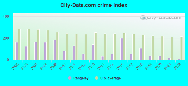
Crime rate in Rangeley detailed stats: murders, rapes, robberies, assaults, burglaries, thefts, arson
Full-time law enforcement employees in 2021, including police officers: 2 (2 officers - 2 male; 0 female).
| Officers per 1,000 residents here: | 1.74 |
| Maine average: | 1.71 |
 Recent articles from our blog. Our writers, many of them Ph.D. graduates or candidates, create easy-to-read articles on a wide variety of topics.

 | SMALL HOUSES (year-round) (229 replies) |
| Grants Camps Rangeley? (1 reply) |
| Thinking of moving to Maine from FL... (44 replies) |
| Canoe Trip Advice Sought (26 replies) |
| Knocking down 1890s house (13 replies) |
| Differences between Rangeley Lake, & Moosehead Lake, (5 replies) |
Latest news from Rangeley, ME collected exclusively by city-data.com from local newspapers, TV, and radio stations
Ancestries: United States (26.7%), English (23.9%), Irish (13.1%), French (7.6%), German (5.7%), Italian (2.8%).
Current Local Time: EST time zone
Incorporated on 03/29/1855
Elevation: 1545 feet
Land area: 41.6 square miles.
Population density: 28 people per square mile (very low).
25 residents are foreign born (1.2% Europe, 1.1% North America).
| This town: | 2.4% |
| Maine: | 2.9% |
| Rangeley town: | 1.1% ($1,243) |
| Maine: | 1.5% ($1,417) |
Nearest city with pop. 50,000+: Portland, ME  (92.2 miles , pop. 64,249).
Nearest city with pop. 200,000+: Boston, MA (183.4 miles , pop. 589,141).
Nearest city with pop. 1,000,000+: Bronx, NY (326.3 miles , pop. 1,332,650).
Nearest cities:
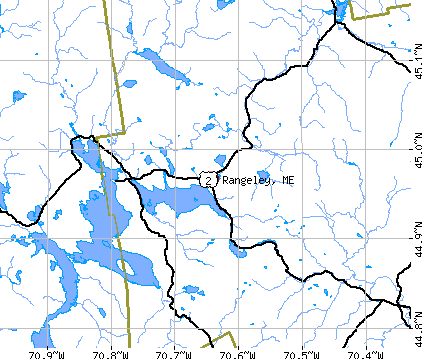
), Latitude: 44.96 N, Longitude: 70.72 W
Area code: 207
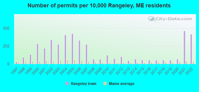
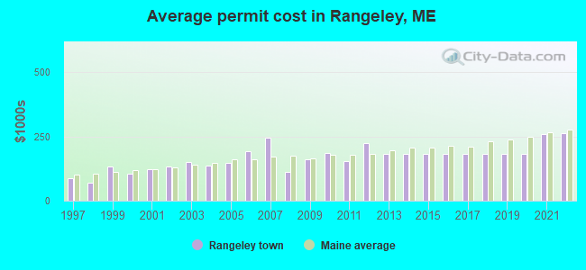
Single-family new house construction building permits:
- 2022: 44 buildings, average cost: $263,300
- 2021: 49 buildings, average cost: $259,200
- 2020: 7 buildings, average cost: $184,200
- 2019: 6 buildings, average cost: $184,200
- 2018: 6 buildings, average cost: $184,200
- 2017: 6 buildings, average cost: $184,200
- 2016: 6 buildings, average cost: $184,200
- 2015: 6 buildings, average cost: $184,200
- 2014: 7 buildings, average cost: $184,200
- 2013: 5 buildings, average cost: $184,200
- 2012: 11 buildings, average cost: $223,500
- 2011: 8 buildings, average cost: $153,100
- 2010: 13 buildings, average cost: $185,400
- 2009: 7 buildings, average cost: $162,900
- 2008: 7 buildings, average cost: $113,600
- 2007: 29 buildings, average cost: $246,900
- 2006: 35 buildings, average cost: $191,800
- 2005: 45 buildings, average cost: $146,400
- 2004: 43 buildings, average cost: $135,900
- 2003: 29 buildings, average cost: $150,400
- 2002: 36 buildings, average cost: $134,200
- 2001: 23 buildings, average cost: $121,600
- 2000: 30 buildings, average cost: $103,700
- 1999: 14 buildings, average cost: $133,900
- 1998: 10 buildings, average cost: $71,000
- 1997: 3 buildings, average cost: $85,700
| Here: | 4.6% |
| Maine: | 3.4% |
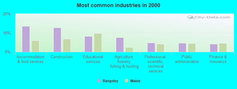
- Accommodation & food services (13.5%)
- Construction (12.7%)
- Educational services (8.2%)
- Agriculture, forestry, fishing & hunting (7.6%)
- Professional, scientific, technical services (4.8%)
- Public administration (4.6%)
- Finance & insurance (4.2%)

- Construction (22.2%)
- Agriculture, forestry, fishing & hunting (12.4%)
- Accommodation & food services (10.2%)
- Educational services (5.5%)
- Administrative & support & waste management services (5.1%)
- Motor vehicle & parts dealers (4.0%)
- Public administration (4.0%)
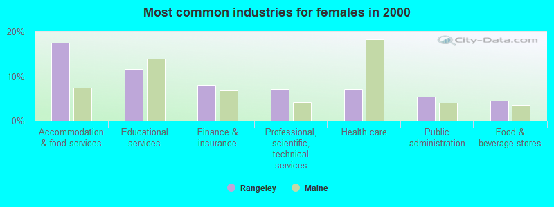
- Accommodation & food services (17.5%)
- Educational services (11.7%)
- Finance & insurance (8.1%)
- Professional, scientific, technical services (7.2%)
- Health care (7.2%)
- Public administration (5.4%)
- Food & beverage stores (4.5%)

- Other management occupations, except farmers and farm managers (10.6%)
- Other sales and related occupations, including supervisors (8.8%)
- Carpenters (5.0%)
- Building and grounds cleaning and maintenance occupations (5.0%)
- Preschool, kindergarten, elementary, and middle school teachers (4.2%)
- Other production occupations, including supervisors (4.2%)
- Other food preparation and serving workers, including supervisors (4.0%)

- Other management occupations, except farmers and farm managers (10.5%)
- Carpenters (9.1%)
- Other sales and related occupations, including supervisors (9.1%)
- Other production occupations, including supervisors (6.9%)
- Building and grounds cleaning and maintenance occupations (5.8%)
- Other food preparation and serving workers, including supervisors (5.1%)
- Driver/sales workers and truck drivers (4.7%)

- Other management occupations, except farmers and farm managers (10.8%)
- Bookkeeping, accounting, and auditing clerks (9.0%)
- Other sales and related occupations, including supervisors (8.5%)
- Preschool, kindergarten, elementary, and middle school teachers (8.1%)
- Secretaries and administrative assistants (7.6%)
- Waiters and waitresses (4.9%)
- Cooks and food preparation workers (4.0%)
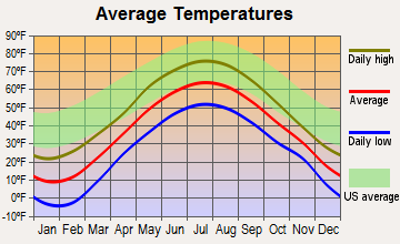
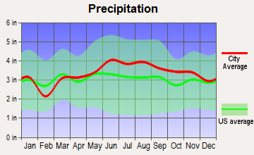
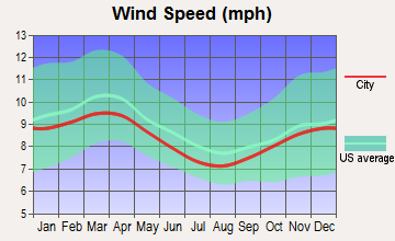
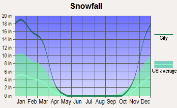
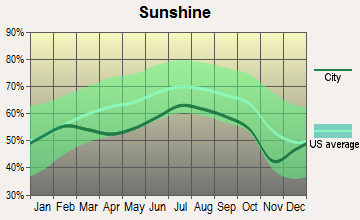
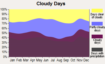
Average climate in Rangeley, Maine
Based on data reported by over 4,000 weather stations

Earthquake activity:
Rangeley-area historical earthquake activity is significantly above Maine state average. It is 78% smaller than the overall U.S. average.On 4/20/2002 at 10:50:47, a magnitude 5.3 (5.3 ML, Depth: 3.0 mi, Class: Moderate, Intensity: VI - VII) earthquake occurred 149.7 miles away from Rangeley center
On 4/20/2002 at 10:50:47, a magnitude 5.2 (5.2 MB, 4.2 MS, 5.2 MW, 5.0 MW) earthquake occurred 151.1 miles away from the city center
On 10/7/1983 at 10:18:46, a magnitude 5.3 (5.1 MB, 5.3 LG, 5.1 ML) earthquake occurred 192.1 miles away from Rangeley center
On 10/16/2012 at 23:12:25, a magnitude 4.7 (4.7 ML, Depth: 10.0 mi, Class: Light, Intensity: IV - V) earthquake occurred 94.3 miles away from Rangeley center
On 1/19/1982 at 00:14:42, a magnitude 4.7 (4.5 MB, 4.7 MD, 4.5 LG) earthquake occurred 110.0 miles away from the city center
On 8/21/1996 at 07:54:14, a magnitude 3.8 (3.8 LG, 3.6 LG, Depth: 6.2 mi, Class: Light, Intensity: II - III) earthquake occurred 62.1 miles away from Rangeley center
Magnitude types: regional Lg-wave magnitude (LG), body-wave magnitude (MB), duration magnitude (MD), local magnitude (ML), surface-wave magnitude (MS), moment magnitude (MW)
Natural disasters:
The number of natural disasters in Franklin County (27) is a lot greater than the US average (15).Major Disasters (Presidential) Declared: 19
Emergencies Declared: 7
Causes of natural disasters: Floods: 16, Storms: 14, Snows: 7, Heavy Rains: 2, Hurricanes: 2, Blizzard: 1, Ice Storm: 1, Landslide: 1, Snowfall: 1, Tropical Storm: 1, Wind: 1, Winter Storm: 1, Other: 2 (Note: some incidents may be assigned to more than one category).

Airports and other landing facilities located in Rangeley:
- Steven A Bean Municipal Airport (8B0) (Runways: 1, Air Taxi Ops: 50, Itinerant Ops: 1,200, Local Ops: 1,200, Military Ops: 150)
- Rangeley Lake Seaplane Base (M57)
Colleges/universities with over 2000 students nearest to Rangeley:
- University of Maine at Farmington (about 35 miles; Farmington, ME; Full-time enrollment: 2,036)
- University of Maine at Augusta (about 63 miles; Augusta, ME; FT enrollment: 3,204)
- Saint Joseph's College of Maine (about 80 miles; Standish, ME; FT enrollment: 2,010)
- University of Southern Maine (about 93 miles; Portland, ME; FT enrollment: 6,647)
- Southern Maine Community College (about 94 miles; South Portland, ME; FT enrollment: 4,666)
- Husson University (about 95 miles; Bangor, ME; FT enrollment: 2,421)
- Plymouth State University (about 97 miles; Plymouth, NH; FT enrollment: 4,838)
Public high school in Rangeley:
- RANGELEY LAKES REGIONAL SCHOOL (Location: 43 MERDOLIA ROAD, Grades: KG-12)
Points of interest:
Notable locations in Rangeley: North Camps (A), Mountain View Camps (B), Mingo Springs Golf Course (C), Haines Landing Marina (D), Clear Water Sporting Camps (E), Bald Mountain Camps (F), Oquossoc Angling Association (G), Rangeley Volunteer Fire Department Rangeley Station (H), Rangeley Volunteer Fire Department Oquossoc Station (I), Northstar Ambulance Rangeley (J), Wilhelm Reich Museum (K), Tranet Library (L), Rangeley Public Library (M), Rangeley Lakes Region Historical Society (N), Rangeley Lakes Chamber of Commerce (O), Orgonon Museum (P). Display/hide their locations on the map
Churches in Rangeley include: Church of the Good Shepherd (A), Saint Luke Catholic Church (B), Rangeley Free Baptist Church (C), Rangeley Congregational Church (D), Our Lady of the Lakes Catholic Church (E), Oquossoc Log Church (F). Display/hide their locations on the map
Cemetery: Rangeley Village Cemetery (1). Display/hide its location on the map
Lakes, reservoirs, and swamps: Yorks Logan (A), Beaver Bog (B), Cloutman Pond (C), Ellis Pond (D), Gile Logan (E), Long Logan (F), Lost Logan (G), Nutting Pond (H). Display/hide their locations on the map
Streams, rivers, and creeks: South Bog Stream (A), Whetstone Brook (B), Rangeley River (C), Quimby Brook (D), Kennebago River (E), Kamankeag Brook (F), Hatchery Brook (G), Nile Brook (H). Display/hide their locations on the map
Park in Rangeley: Hunter Cove Wildlife Sanctuary (1). Display/hide its location on the map
Tourist attraction: Wilheim Reich Museum (Dodge Pond Road) (1). Display/hide its approximate location on the map
Hotels: North Country Inn B & B (2541 Main) (1), Lyons Lakeside & Cabins (5 Lyons Lane) (2), Mooselookmeguntic House Cabin Rentals (Route 4) (3), Niboban Camps (Shore Drive Rangeley Plantation) (4). Display/hide their approximate locations on the map
Drinking water stations with addresses in Rangeley and their reported violations in the past:
RANGELEY WATER DISTRICT (Population served: 1,340, Groundwater):Past monitoring violations:SADDLEBACK INC (Population served: 950, Groundwater):
- One routine major monitoring violation
Past health violations:COUNTRY CLUB INN (Population served: 388, Groundwater):Past monitoring violations:
- MCL, Monthly (TCR) - In AUG-2011, Contaminant: Coliform. Follow-up actions: St Public Notif requested (SEP-16-2011), St Formal NOV issued (SEP-16-2011), St Compliance achieved (SEP-20-2011), St Public Notif received (OCT-04-2011)
- 3 routine major monitoring violations
Past health violations:GRANTS KENNEBAGO CAMPS (Population served: 250, Groundwater):
- MCL, Monthly (TCR) - In NOV-2012, Contaminant: Coliform. Follow-up actions: St Public Notif requested (NOV-30-2012), St Formal NOV issued (NOV-30-2012), St Public Notif received (DEC-06-2012), St Compliance achieved (DEC-19-2012)
- MCL, Monthly (TCR) - In OCT-2012, Contaminant: Coliform. Follow-up actions: St Public Notif requested (OCT-29-2012), St Formal NOV issued (OCT-29-2012), St Public Notif received (NOV-16-2012), St Compliance achieved (DEC-19-2012)
Past monitoring violations:OQUOSSOC CAMPGROUND (Population served: 75, Groundwater):
- 4 routine major monitoring violations
- One regular monitoring violation
Past monitoring violations:SADDLEBACK LAKE LODGE CONDO (Population served: 68, Groundwater):
- 6 routine major monitoring violations
- 4 regular monitoring violations
Past health violations:ROCK POND CONDOS AT SADDLEBACK (Population served: 67, Groundwater):
- MCL, Monthly (TCR) - In NOV-2012, Contaminant: Coliform. Follow-up actions: St Public Notif requested (NOV-28-2012), St Formal NOV issued (NOV-28-2012), St Public Notif received (DEC-18-2012), St Compliance achieved (DEC-28-2012)
- MCL, Monthly (TCR) - In OCT-2012, Contaminant: Coliform. Follow-up actions: St Public Notif requested (NOV-13-2012), St Formal NOV issued (NOV-13-2012), St Public Notif received (DEC-03-2012), St Compliance achieved (DEC-28-2012)
- MCL, Monthly (TCR) - In DEC-2008, Contaminant: Coliform. Follow-up actions: St Public Notif requested (DEC-18-2008), St Formal NOV issued (DEC-18-2008), St Public Notif received (DEC-30-2008), St Compliance achieved (OCT-16-2009)
- MCL, Monthly (TCR) - In NOV-2008, Contaminant: Coliform. Follow-up actions: St Public Notif requested (NOV-21-2008), St Formal NOV issued (NOV-21-2008), St Public Notif received (DEC-23-2008), St Compliance achieved (OCT-16-2009)
- MCL, Monthly (TCR) - In AUG-2008, Contaminant: Coliform. Follow-up actions: St Public Notif requested (AUG-18-2008), St Formal NOV issued (AUG-18-2008), St Public Notif received (SEP-04-2008), St Compliance achieved (OCT-16-2009)
- MCL, Monthly (TCR) - Between JUL-2008 and SEP-2008, Contaminant: Coliform. Follow-up actions: St Public Notif requested (AUG-01-2008), St Formal NOV issued (AUG-01-2008), St Public Notif received (AUG-11-2008), St Compliance achieved (OCT-16-2009)
Past health violations:SAM-O-SET ASSOCIATION (Population served: 48, Groundwater):Past monitoring violations:
- MCL, Monthly (TCR) - Between OCT-2008 and DEC-2008, Contaminant: Coliform. Follow-up actions: St Public Notif requested (NOV-17-2008), St Formal NOV issued (NOV-17-2008), St Compliance achieved (DEC-04-2008), St Public Notif received (SEP-09-2010)
- MCL, Monthly (TCR) - In AUG-2008, Contaminant: Coliform. Follow-up actions: St Public Notif requested (AUG-15-2008), St Formal NOV issued (AUG-15-2008), St Public Notif received (SEP-17-2008), St Compliance achieved (SEP-07-2011), St Intentional no-action (SEP-09-2011)
- 2 routine major monitoring violations
Past monitoring violations:
- One regular monitoring violation
Drinking water stations with addresses in Rangeley that have no violations reported:
- BLACK BROOK COVE CAMPGROUND (Population served: 165, Primary Water Source Type: Groundwater)
| This town: | 2.0 people |
| Maine: | 2.3 people |
| This town: | 58.8% |
| Whole state: | 62.9% |
| This town: | 7.1% |
| Whole state: | 9.4% |
Likely homosexual households (counted as self-reported same-sex unmarried-partner households)
- Lesbian couples: 0.3% of all households
- Gay men: 0.2% of all households
| This town: | 11.7% |
| Whole state: | 10.9% |
| This town: | 3.3% |
| Whole state: | 4.1% |
Banks with branches in Rangeley (2011 data):
- Franklin Savings Bank: Rangeley Branch at 2573 Main Street, branch established on 1975/02/03. Info updated 2006/11/03: Bank assets: $325.7 mil, Deposits: $237.8 mil, headquarters in Farmington, ME, positive income, Commercial Lending Specialization, 8 total offices, Holding Company: Fsb Bancorp, Mhc
- The Camden National Bank: Rangeley Branch at 2484 Main Street, branch established on 1965/03/31. Info updated 2008/02/27: Bank assets: $2,266.8 mil, Deposits: $1,604.6 mil, headquarters in Camden, ME, positive income, Commercial Lending Specialization, 39 total offices, Holding Company: Camden National Corporation
For population 15 years and over in Rangeley:
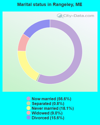
- Never married: 18.1%
- Now married: 56.6%
- Separated: 0.8%
- Widowed: 9.0%
- Divorced: 15.6%
For population 25 years and over in Rangeley:
- High school or higher: 89.7%
- Bachelor's degree or higher: 26.7%
- Graduate or professional degree: 8.5%
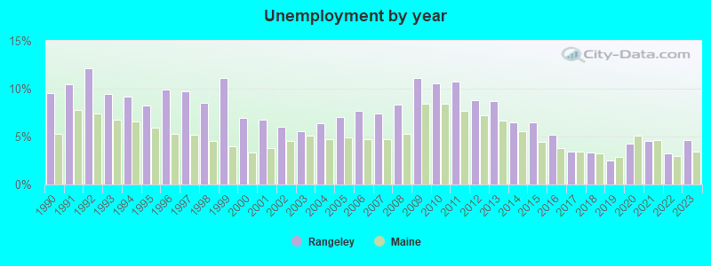
- Unemployed: 4.8%
- Mean travel time to work (commute): 12.9 minutes
| Here: | 9.8 |
| Maine average: | 11.2 |
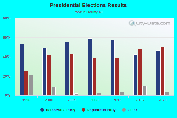
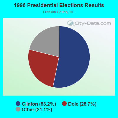
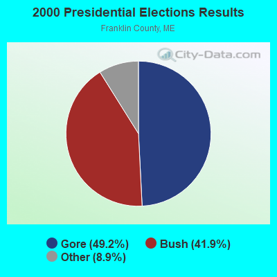
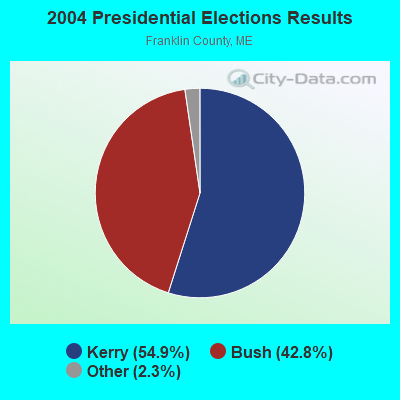
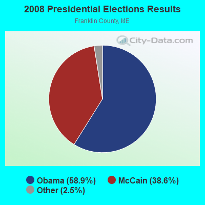
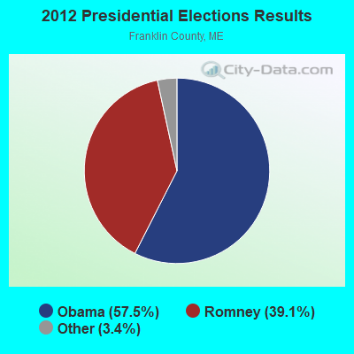

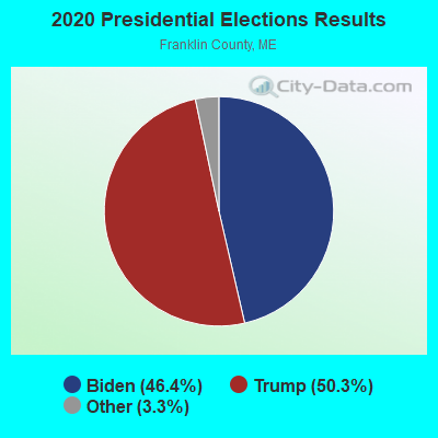
Graphs represent county-level data. Detailed 2008 Election Results
Religion statistics for Rangeley, ME (based on Franklin County data)
| Religion | Adherents | Congregations |
|---|---|---|
| Catholic | 3,936 | 5 |
| Mainline Protestant | 2,003 | 21 |
| Evangelical Protestant | 908 | 16 |
| Other | 427 | 2 |
| None | 23,494 | - |
Food Environment Statistics:
| This county: | 4.68 / 10,000 pop. |
| Maine: | 2.80 / 10,000 pop. |
| Franklin County: | 0.33 / 10,000 pop. |
| Maine: | 0.14 / 10,000 pop. |
| Franklin County: | 3.01 / 10,000 pop. |
| State: | 2.20 / 10,000 pop. |
| This county: | 6.69 / 10,000 pop. |
| Maine: | 5.75 / 10,000 pop. |
| Franklin County: | 14.38 / 10,000 pop. |
| State: | 11.02 / 10,000 pop. |
| Franklin County: | 7.3% |
| Maine: | 8.2% |
| Franklin County: | 24.4% |
| Maine: | 25.0% |
Businesses in Rangeley, ME
- H&R Block: 1
Strongest AM radio stations in Rangeley:
- WTME (780 AM; 10 kW; RUMFORD, ME; Owner: MOUNTAIN VALLEY BROADCASTING, INC.)
- WSKW (1160 AM; 10 kW; SKOWHEGAN, ME; Owner: MOUNTAIN WIRELESS, INCORPORATED)
- WCHP (760 AM; 35 kW; CHAMPLAIN, NY; Owner: CHAMPLAIN RADIO, INC.)
- WRKO (680 AM; 50 kW; BOSTON, MA; Owner: ENTERCOM BOSTON LICENSE, LLC)
- WEEI (850 AM; 50 kW; BOSTON, MA; Owner: ENTERCOM BOSTON LICENSE, LLC)
- WNNZ (640 AM; 50 kW; WESTFIELD, MA; Owner: CLEAR CHANNEL BROADCASTING LICENSES, INC.)
- WCRN (830 AM; 50 kW; WORCESTER, MA; Owner: CARTER BROADCASTING CORPORATION)
- WBZ (1030 AM; 50 kW; BOSTON, MA; Owner: INFINITY BROADCASTING OPERATIONS, INC.)
- WMTW (870 AM; 10 kW; GORHAM, ME; Owner: RADIO PARTNERS OF MAINE, L.P.)
- WGY (810 AM; 50 kW; SCHENECTADY, NY; Owner: CLEAR CHANNEL BROADCASTING LICENSES, INC.)
- WKOX (1200 AM; 50 kW; FRAMINGHAM, MA; Owner: CAPSTAR TX LIMITED PARTNERSHIP)
- WICY (1490 AM; 50 kW; MALONE, NY; Owner: CARTIER COMMUNICATIONS INC.)
- WALE (990 AM; 50 kW; GREENVILLE, RI; Owner: NORTH AMERICAN BROADCASTING CO., INC.)
Strongest FM radio stations in Rangeley:
- WTOS-FM (105.1 FM; SKOWHEGAN, ME; Owner: CAPSTAR TX LIMITED PARTNERSHIP)
- WLOB-FM (96.3 FM; RUMFORD, ME; Owner: ATLANTIC COAST RADIO, LLC)
- WPKQ (103.7 FM; NORTH CONWAY, NH; Owner: CITADEL BROADCASTING COMPANY)
- WHOM (94.9 FM; MT. WASHINGTON, NH; Owner: CITADEL BROADCASTING COMPANY)
- WTBM (100.7 FM; MEXICO, ME; Owner: MOUNTAIN VALLEY BROADCASTING, INC.)
- Rangeley, Maine
- Fatal accident count9
- Vehicles involved in fatal accidents12
- Fatal accidents involving drunk persons:6
- Fatalities11
- Persons involved in fatal accidents29
- Pedestrians involved in fatal accidents0
- Maine average
- Fatal accident count1247
- Vehicles involved in fatal accidents1805
- Fatal accidents involving drunk persons531
- Fatalities1384
- Persons involved in fatal accidents3024
- Pedestrians involved in fatal accidents74
- National Bridge Inventory (NBI) Statistics
- 6Number of bridges
- 75ft / 23.2mTotal length
- 3,270Total average daily traffic
- 161Total average daily truck traffic
- 4,830Total future (year 2036) average daily traffic
FCC Registered Cell Phone Towers:
1 (See the full list of FCC Registered Cell Phone Towers in Rangeley)FCC Registered Antenna Towers:
20 (See the full list of FCC Registered Antenna Towers)FCC Registered Broadcast Land Mobile Towers:
2- Lat: 44.944778 Lon: -70.774861, Call Sign: WQXR865,
Assigned Frequencies: 456.187 MHz, Grant Date: 05/20/2016, Expiration Date: 05/20/2026, Cancellation Date: 05/02/2017, Certifier: Steven Faulhaber, Registrant: Central Maine Power Company, 57 Old Winthrop Road, Augusta, ME 04380, Phone: (207) 626-9427
- Lat: 44.944778 Lon: -70.774861, Call Sign: WQYT657,
Assigned Frequencies: 451.762 MHz, 456.762 MHz, Grant Date: 01/17/2017, Expiration Date: 01/17/2027, Cancellation Date: 11/22/2017, Certifier: Steven Faulhaber, Registrant: Central Maine Power Company, 57 Old Winthrop Road, Augusta, ME 04380, Phone: (207) 626-9427, Email:
FCC Registered Microwave Towers:
1- W KENNEBAGO, West Kennebago Mountain (Lat: 45.107778 Lon: -70.816667), Type: Mast, Structure height: 24.4 m, Call Sign: WQNM772,
Assigned Frequencies: 933.575 MHz, 6695.00 MHz, 6695.00 MHz, 6695.00 MHz, 6695.00 MHz, 6695.00 MHz, 6695.00 MHz, 6695.00 MHz, 6695.00 MHz, 6695.00 MHz, Grant Date: 01/29/2021, Expiration Date: 03/25/2031, Certifier: David E Mars, Registrant: State Of Maine, O.I.T., Radio Operations, 66 Industrial Drive, Augusta, ME 04333-0147, Phone: (207) 624-9990, Email:
FCC Registered Maritime Coast & Aviation Ground Towers:
3- Rangeley Municipal Airport (Lat: 44.933889 Lon: -70.750833), Type: Tower, Call Sign: WRLB2029,
Assigned Frequencies: 0.22151 MHz, Grant Date: 03/18/2015, Expiration Date: 01/27/2025, Registrant: Rangeley Dispatch Centre, 12 Allen Street, Rangeley, ME 04970, Phone: (207) 864-2162, Fax: (207) 864-2162, Email:
- Rangeley Municipal Airport (Lat: 44.983389 Lon: -70.666167), Type: Building, Overall height: 4 m, Call Sign: WWP8,
Assigned Frequencies: 122.900 MHz, Grant Date: 12/06/2017, Expiration Date: 11/10/2027, Registrant: Hussey Communications, 58 Patterson Ave, Winslow, ME 04901, Phone: (207) 873-8406, Email:
- Steven A Bean Municipal Airport Loon Lake Road (Lat: 44.990056 Lon: -70.661722), Type: Tower, Structure height: 8.5 m, Overall height: 9.1 m, Call Sign: WQCX399, Licensee ID: L00108174,
Assigned Frequencies: 118.000 MHz, Grant Date: 04/15/2015, Expiration Date: 06/16/2025, Certifier: Rudolph C Davis, Registrant: Town Of Rangeley
FCC Registered Amateur Radio Licenses:
12 (See the full list of FCC Registered Amateur Radio Licenses in Rangeley)FAA Registered Aircraft Manufacturers and Dealers:
2 (See the full list of FAA Registered Manufacturers and Dealers in Rangeley)FAA Registered Aircraft:
6 (See the full list of FAA Registered Aircraft)
- 78.5%Fuel oil, kerosene, etc.
- 15.8%Wood
- 3.6%Bottled, tank, or LP gas
- 2.1%Electricity
- 89.3%Fuel oil, kerosene, etc.
- 7.4%Electricity
- 3.3%Wood
Rangeley compared to Maine state average:
- Unemployed percentage below state average.
- Black race population percentage significantly below state average.
- Hispanic race population percentage below state average.
- Median age significantly above state average.
- Foreign-born population percentage below state average.
- Length of stay since moving in significantly above state average.
- Number of rooms per house significantly below state average.
- House age significantly below state average.
- Number of college students below state average.