Porter Springs, Texas
Submit your own pictures of this place and show them to the world
- OSM Map
- General Map
- Google Map
- MSN Map

| Males: 674 | |
| Females: 675 |
| Median resident age: | 45.4 years |
| Texas median age: | 32.3 years |
Zip code: 75835
| Porter Springs: | $55,261 |
| TX: | $72,284 |
Estimated per capita income in 2022: $32,574 (it was $18,369 in 2000)
Porter Springs CCD income, earnings, and wages data
Estimated median house or condo value in 2022: $142,020 (it was $46,300 in 2000)
| Porter Springs: | $142,020 |
| TX: | $275,400 |
Mean prices in 2022: all housing units: $200,721; detached houses: $230,980; townhouses or other attached units: $182,950; mobile homes: $106,180; occupied boats, rvs, vans, etc.: $90,642
Porter Springs, TX residents, houses, and apartments details
Detailed information about poverty and poor residents in Porter Springs, TX


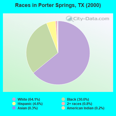
- 88464.1%White alone
- 41430.0%Black alone
- 634.6%Hispanic
- 110.8%Two or more races
- 40.3%Asian alone
- 30.2%American Indian alone
Races in Porter Springs detailed stats: ancestries, foreign born residents, place of birth
 Recent articles from our blog. Our writers, many of them Ph.D. graduates or candidates, create easy-to-read articles on a wide variety of topics.
Current Local Time: CST time zone
Land area: 179.2 square miles.
Population density: 7.5 people per square mile (very low).

| Porter Springs CCD: | 0.9% ($437) |
| Texas: | 1.8% ($1,393) |
Nearest city with pop. 50,000+: Bryan, TX  (58.1 miles , pop. 65,660).
Nearest city with pop. 200,000+: Southeast Montgomery, TX (71.1 miles , pop. 208,076).
Nearest city with pop. 1,000,000+: Houston, TX (102.2 miles , pop. 1,953,631).
Nearest cities:
), )Latitude: 31.22 N, Longitude: 95.64 W

| Here: | 2.8% |
| Texas: | 3.5% |
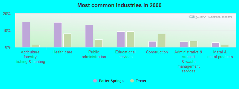
- Agriculture, forestry, fishing & hunting (15.1%)
- Health care (14.8%)
- Public administration (13.4%)
- Educational services (9.4%)
- Construction (3.6%)
- Administrative & support & waste management services (3.4%)
- Metal & metal products (2.9%)
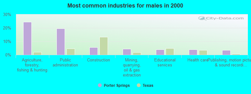
- Agriculture, forestry, fishing & hunting (24.4%)
- Public administration (19.6%)
- Construction (5.5%)
- Mining, quarrying, oil & gas extraction (4.5%)
- Educational services (3.9%)
- Health care (3.9%)
- Publishing, motion picture & sound recording industries (3.5%)
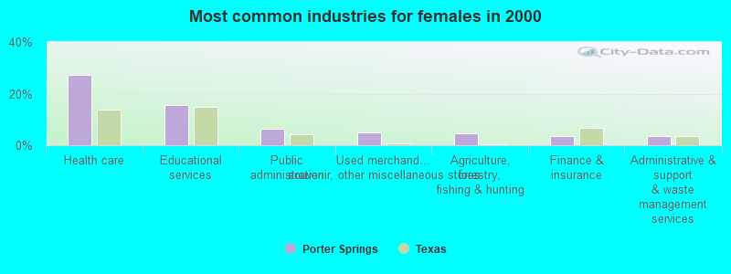
- Health care (27.1%)
- Educational services (15.5%)
- Public administration (6.5%)
- Used merchandise, gift, novelty, souvenir, other miscellaneous stores (5.1%)
- Agriculture, forestry, fishing & hunting (4.7%)
- Finance & insurance (3.6%)
- Administrative & support & waste management services (3.6%)
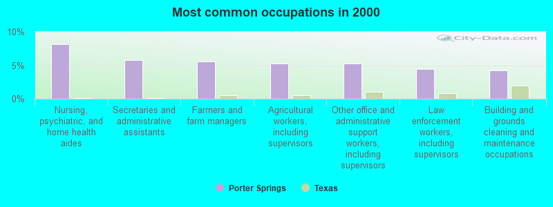
- Nursing, psychiatric, and home health aides (8.2%)
- Secretaries and administrative assistants (5.8%)
- Farmers and farm managers (5.6%)
- Agricultural workers, including supervisors (5.3%)
- Other office and administrative support workers, including supervisors (5.3%)
- Law enforcement workers, including supervisors (4.4%)
- Building and grounds cleaning and maintenance occupations (4.3%)

- Agricultural workers, including supervisors (10.0%)
- Farmers and farm managers (9.0%)
- Law enforcement workers, including supervisors (8.4%)
- Electrical equipment mechanics and other installation, maintenance, and repair workers, including supervisors (5.5%)
- Building and grounds cleaning and maintenance occupations (5.1%)
- Fire fighting and prevention workers, including supervisors (4.5%)
- Other sales and related occupations, including supervisors (4.5%)
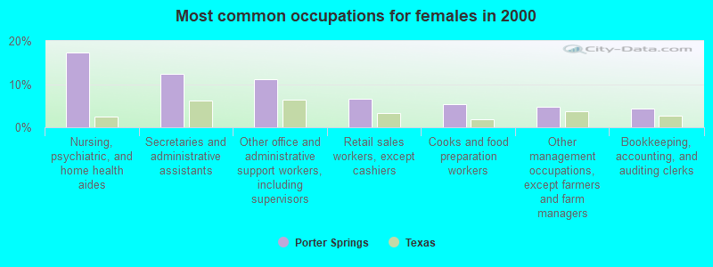
- Nursing, psychiatric, and home health aides (17.3%)
- Secretaries and administrative assistants (12.3%)
- Other office and administrative support workers, including supervisors (11.2%)
- Retail sales workers, except cashiers (6.5%)
- Cooks and food preparation workers (5.4%)
- Other management occupations, except farmers and farm managers (4.7%)
- Bookkeeping, accounting, and auditing clerks (4.3%)
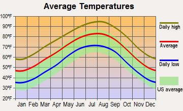
Average climate in Porter Springs, Texas
Based on data reported by over 4,000 weather stations


Tornado activity:
Porter Springs-area historical tornado activity is near Texas state average. It is 24% greater than the overall U.S. average.
On 5/16/1953, a category F3 (max. wind speeds 158-206 mph) tornado 2.0 miles away from the Porter Springs place center killed one person and injured 8 people.
On 4/30/1954, a category F3 tornado 20.2 miles away from the place center injured 6 people and caused between $50,000 and $500,000 in damages.
Earthquake activity:
Porter Springs-area historical earthquake activity is significantly above Texas state average. It is 282% greater than the overall U.S. average.On 5/17/2012 at 08:12:00, a magnitude 4.8 (4.8 MW, Depth: 3.1 mi, Class: Light, Intensity: IV - V) earthquake occurred 89.0 miles away from Porter Springs center
On 11/6/2011 at 03:53:10, a magnitude 5.7 (5.7 MW, Depth: 3.2 mi, Class: Moderate, Intensity: VI - VII) earthquake occurred 305.0 miles away from the city center
On 9/3/2016 at 12:02:44, a magnitude 5.8 (5.8 MW, Depth: 3.5 mi) earthquake occurred 367.3 miles away from Porter Springs center
On 9/2/2013 at 23:51:15, a magnitude 4.3 (4.3 MW, Depth: 2.9 mi) earthquake occurred 85.5 miles away from Porter Springs center
On 9/2/2013 at 21:52:38, a magnitude 4.2 (4.2 MW, Depth: 3.0 mi) earthquake occurred 83.0 miles away from the city center
On 10/20/2011 at 12:24:41, a magnitude 4.8 (4.8 MW, Depth: 3.1 mi) earthquake occurred 219.2 miles away from the city center
Magnitude types: moment magnitude (MW)
Natural disasters:
The number of natural disasters in Houston County (20) is greater than the US average (15).Major Disasters (Presidential) Declared: 11
Emergencies Declared: 7
Causes of natural disasters: Storms: 9, Floods: 8, Fires: 5, Hurricanes: 4, Tornadoes: 3, Wind: 1, Other: 2 (Note: some incidents may be assigned to more than one category).
Hospitals and medical centers near Porter Springs:
- AFTERCARE VISITING NURSE SERVICE LLC (Home Health Center, about 14 miles away; CROCKETT, TX)
- COMMUNITY CARE CENTER OF CROCKETT (Nursing Home, about 14 miles away; CROCKETT, TX)
- HOUSTON COUNTY HOME HEALTH CARE INC (Home Health Center, about 14 miles away; CROCKETT, TX)
- WHITEHALL NURSING CENTER INC (Nursing Home, about 14 miles away; CROCKETT, TX)
- WINFIELD NURSING CENTER (Nursing Home, about 14 miles away; CROCKETT, TX)
- EAST TEXAS MEDICAL CENTER CROCKETT Acute Care Hospitals (about 14 miles away; CROCKETT, TX)
- RENAL CARE GROUP CROCKETT (Dialysis Facility, about 14 miles away; CROCKETT, TX)
Colleges/universities with over 2000 students nearest to Porter Springs:
- Sam Houston State University (about 35 miles; Huntsville, TX; Full-time enrollment: 16,233)
- Angelina College (about 54 miles; Lufkin, TX; FT enrollment: 3,478)
- Texas A & M University-College Station (about 60 miles; College Station, TX; FT enrollment: 46,550)
- Stephen F Austin State University (about 67 miles; Nacogdoches, TX; FT enrollment: 11,542)
- Trinity Valley Community College (about 69 miles; Athens, TX; FT enrollment: 5,333)
- Lone Star College System (about 73 miles; The Woodlands, TX; FT enrollment: 45,205)
- Navarro College (about 78 miles; Corsicana, TX; FT enrollment: 7,711)
Points of interest:
Notable locations in Porter Springs: Langum Quarter (A), Seven J Ramp Ranch (B), Rattlesnake Ranch (C), Alabama Ferry (D), Long Plantation (E), Mose Owens Farm (F), Caroline Williams Farm (G), Wilmore Farm (H), Trinity River Loading and Landing (I), Boseman Blacksmith (J), First Colony Branch Library (K), Austonio Volunteer Fire Department (L), Porter Springs Community Volunteer Fire Department (M), Mose Owens Shinge Mill (N), Mose Owens Syrup Mill (O). Display/hide their locations on the map
Churches in Porter Springs include: Union Prairie Church (A), Union Chapel (B), Pleasant Grove Church (C), Ash Church (D), Austin Church (E), Blue Lake Church (F), Cooper Church (G), Pleasant Grove Methodist Church (H), Union Chapel Baptist Church (I). Display/hide their locations on the map
Cemeteries: Smith Cemetery (1), Campbell Cemetery (2), Mayes Cemetery (3), Smith Cemetery (4), Campbell Cemetery (5), Mount Moriah Cemetery (6), Porter Springs Cemetery (7). Display/hide their locations on the map
Lakes and reservoirs: Dry Lake (A), Rattlesnake Lake (B), Patterson Lake (C), Snag Lake (D), Negro Lake (E), Coon Lake 1 (F), Coon Lake 2 (G), Wirt Lake (H). Display/hide their locations on the map
Streams, rivers, and creeks: Boggy Creek (A), Big Elkhart Creek (B), Hurricane Bayou (C), Dan Jenkins Creek (D), Salt Branch (E), Prairie Branch (F), Pine Branch (G), Moore Branch (H), Cedar Creek (I). Display/hide their locations on the map
| This place: | 2.4 people |
| Texas: | 2.8 people |
| This place: | 68.2% |
| Whole state: | 69.9% |
| This place: | 3.6% |
| Whole state: | 6.0% |
Likely homosexual households (counted as self-reported same-sex unmarried-partner households)
- Lesbian couples: 0.2% of all households
- Gay men: 0.5% of all households
| This place: | 12.9% |
| Whole state: | 15.4% |
| This place: | 2.3% |
| Whole state: | 6.7% |
For population 15 years and over in Porter Springs:
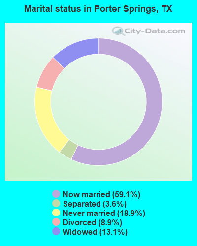
- Never married: 18.9%
- Now married: 59.1%
- Separated: 3.6%
- Widowed: 13.1%
- Divorced: 8.9%
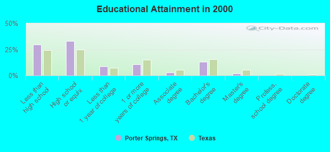
For population 25 years and over in Porter Springs:
- High school or higher: 70.6%
- Bachelor's degree or higher: 15.1%
- Graduate or professional degree: 2.1%
- Unemployed: 7.0%
- Mean travel time to work (commute): 24.3 minutes
| Here: | 12.2 |
| Texas average: | 15.6 |
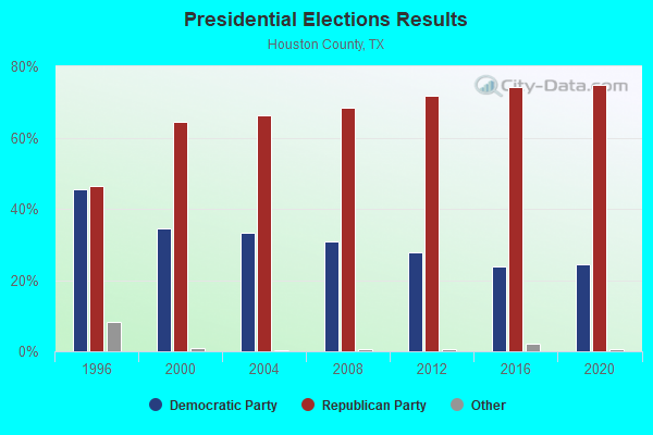
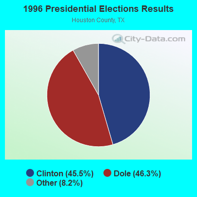
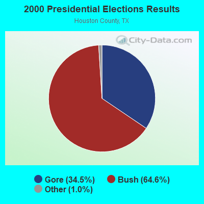


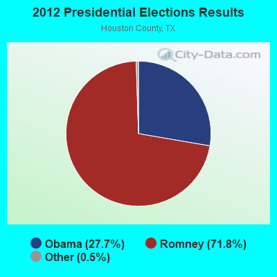
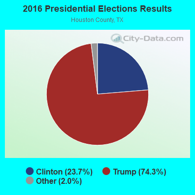
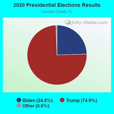
Graphs represent county-level data. Detailed 2008 Election Results
Religion statistics for Porter Springs, TX (based on Houston County data)
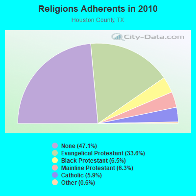
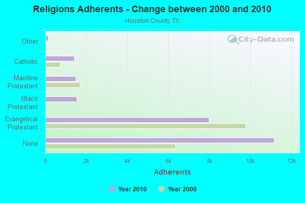
| Religion | Adherents | Congregations |
|---|---|---|
| Evangelical Protestant | 7,982 | 63 |
| Black Protestant | 1,538 | 7 |
| Mainline Protestant | 1,485 | 14 |
| Catholic | 1,411 | 1 |
| Other | 145 | 2 |
| None | 11,171 | - |
Food Environment Statistics:
| Houston County: | 1.32 / 10,000 pop. |
| Texas: | 1.47 / 10,000 pop. |
| Here: | 0.44 / 10,000 pop. |
| State: | 0.14 / 10,000 pop. |
| Houston County: | 1.76 / 10,000 pop. |
| Texas: | 1.11 / 10,000 pop. |
| This county: | 4.41 / 10,000 pop. |
| Texas: | 3.95 / 10,000 pop. |
| Houston County: | 3.97 / 10,000 pop. |
| Texas: | 6.13 / 10,000 pop. |
| This county: | 11.4% |
| Texas: | 8.9% |
| Here: | 29.9% |
| Texas: | 26.6% |
| Houston County: | 17.3% |
| Texas: | 15.7% |
Strongest AM radio stations in Porter Springs:
- KIVY (1290 AM; 2 kW; CROCKETT, TX; Owner: LEON HUNT)
- KGOL (1180 AM; 50 kW; HUMBLE, TX; Owner: ENTRAVISION HOLDINGS, LLC)
- KTRH (740 AM; 50 kW; HOUSTON, TX; Owner: AMFM TEXAS LICENSES LIMITED PARTNERSHIP)
- KSEV (700 AM; 15 kW; TOMBALL, TX; Owner: LIBERMAN BROADCASTING OF HOUSTON LICENSE CORP.)
- WBAP (820 AM; 50 kW; FORT WORTH, TX; Owner: WBAP-KSCS OPERATING, LTD.)
- KEEL (710 AM; 50 kW; SHREVEPORT, LA; Owner: CITICASTERS LICENSES, L.P.)
- KRLD (1080 AM; 50 kW; DALLAS, TX; Owner: TEXAS INFINITY BROADCASTING L.P.)
- KFXR (1190 AM; 50 kW; DALLAS, TX; Owner: CLEAR CHANNEL BROADCASTING LICENSES, INC.)
- KJOJ (880 AM; 10 kW; CONROE, TX; Owner: LIBERMAN BROADCASTING OF HOUSTON LICENSE CORP.)
- KZNE (1150 AM; 10 kW; COLLEGE STATION, TX; Owner: BRYAN BROADCASTING LICENSE SUBSIDIARY, INC.)
- KWKH (1130 AM; 50 kW; SHREVEPORT, LA; Owner: CITICASTERS LICENSES, L.P.)
- KESS (1270 AM; 50 kW; FORT WORTH, TX; Owner: KESS-AM LICENSE CORP.)
- WTAW (1620 AM; 10 kW; COLLEGE STATION, TX; Owner: BRYAN BROADCASTING LICENSE SUBSIDIARY, INC.)
Strongest FM radio stations in Porter Springs:
- KBHT (93.5 FM; CROCKETT, TX; Owner: NICOL BROADCASTING LTD.)
- KIVY-FM (92.7 FM; CROCKETT, TX; Owner: LEON HUNT)
- KTCJ (105.9 FM; CENTERVILLE, TX; Owner: GOOD SAMARITAN COMMUNICATIONS OF PIOCHE, INC.)
- KMVL-FM (100.5 FM; MADISONVILLE, TX; Owner: LEON HUNT DBA HUNT BROADCASTING)
- KTHT (97.1 FM; CLEVELAND, TX; Owner: CXR HOLDINGS, INC.)
- KCKT (88.5 FM; CROCKETT, TX; Owner: AMERICAN FAMILY ASSOCIATION)
- K220EQ (91.9 FM; CROCKETT, TX; Owner: AMERICAN FAMILY ASSOCIATION)
TV broadcast stations around Porter Springs:
- KTWC-LP (Channel 12; CROCKETT, TX; Owner: INTERNATIONAL BROADCASTING NETWORK)
- KIVY-LP (Channel 16; CROCKETT, TX; Owner: JIM GIBBS)
- KBTX-TV (Channel 3; BRYAN, TX; Owner: KWTX-KBTX LICENSEE CORP.)
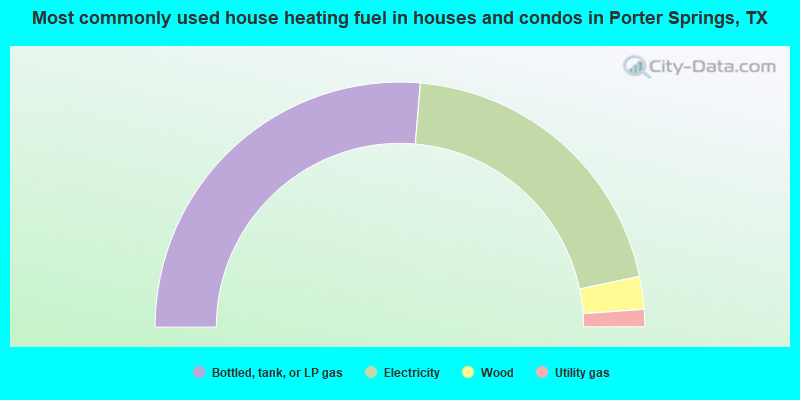
- 52.6%Bottled, tank, or LP gas
- 40.7%Electricity
- 4.3%Wood
- 2.3%Utility gas
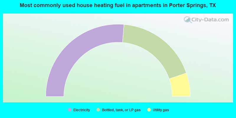
- 52.6%Electricity
- 36.8%Bottled, tank, or LP gas
- 10.5%Utility gas
Porter Springs compared to Texas state average:
- Median house value below state average.
- Unemployed percentage below state average.
- Black race population percentage above state average.
- Hispanic race population percentage significantly below state average.
- Median age significantly above state average.
- Foreign-born population percentage significantly below state average.
- Renting percentage below state average.
- Length of stay since moving in significantly above state average.
- Number of rooms per house significantly below state average.
- House age significantly below state average.
- Number of college students below state average.