Glendale, Texas
Submit your own pictures of this place and show them to the world
- OSM Map
- General Map
- Google Map
- MSN Map

| Males: 858 | |
| Females: 851 |
| Median resident age: | 44.1 years |
| Texas median age: | 32.3 years |
Zip code: 75862
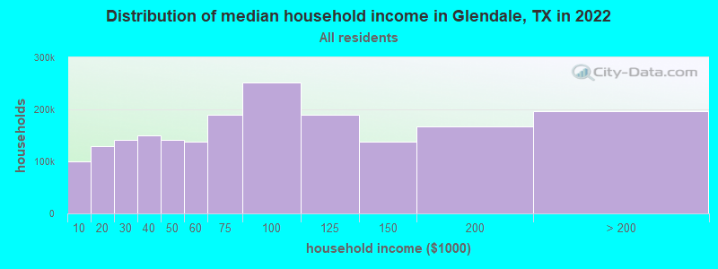
| Glendale: | $55,445 |
| TX: | $72,284 |
Estimated per capita income in 2022: $34,432 (it was $16,959 in 2000)
Glendale CCD income, earnings, and wages data
Estimated median house or condo value in 2022: $126,187 (it was $50,500 in 2000)
| Glendale: | $126,187 |
| TX: | $275,400 |
Mean prices in 2022: all housing units: $172,194; detached houses: $222,112; townhouses or other attached units: $202,999; mobile homes: $74,762
Detailed information about poverty and poor residents in Glendale, TX


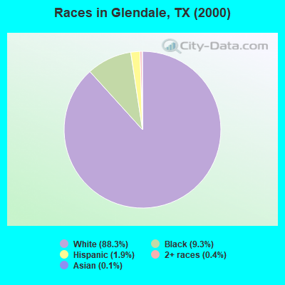
- 1,48888.3%White alone
- 1579.3%Black alone
- 321.9%Hispanic
- 60.4%Two or more races
- 20.1%Asian alone
Races in Glendale detailed stats: ancestries, foreign born residents, place of birth
 Recent articles from our blog. Our writers, many of them Ph.D. graduates or candidates, create easy-to-read articles on a wide variety of topics.
Current Local Time: CST time zone
Elevation: 314 feet
Land area: 148.3 square miles.
Population density: 12 people per square mile (very low).

| Glendale CCD: | 0.8% ($380) |
| Texas: | 1.8% ($1,393) |
Nearest city with pop. 50,000+: Southeast Montgomery, TX (53.1 miles  , pop. 208,076).
Nearest city with pop. 1,000,000+: Houston, TX (84.8 miles , pop. 1,953,631).
Nearest cities:
), ), ), ), Latitude: 30.99 N, Longitude: 95.33 W
Area codes: 817, 682

| Here: | 4.5% |
| Texas: | 3.5% |
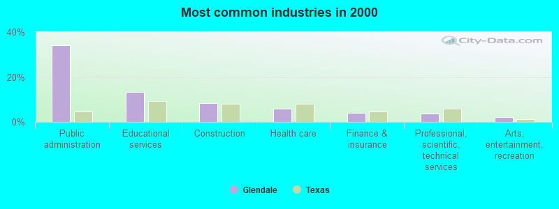
- Public administration (34.0%)
- Educational services (13.3%)
- Construction (8.3%)
- Health care (5.8%)
- Finance & insurance (4.0%)
- Professional, scientific, technical services (3.7%)
- Arts, entertainment, recreation (2.2%)
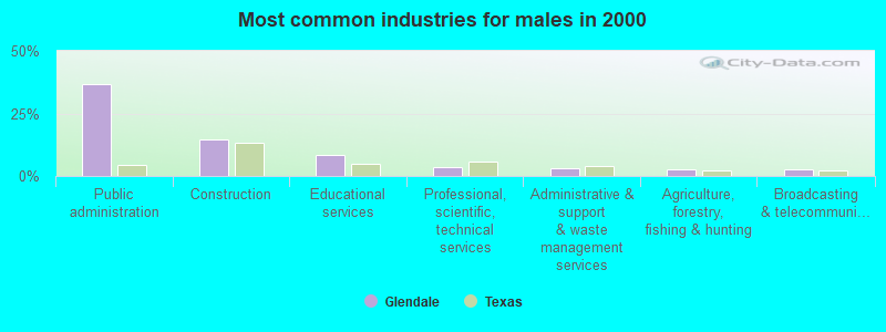
- Public administration (36.6%)
- Construction (14.4%)
- Educational services (8.5%)
- Professional, scientific, technical services (3.6%)
- Administrative & support & waste management services (3.1%)
- Agriculture, forestry, fishing & hunting (2.8%)
- Broadcasting & telecommunications (2.8%)
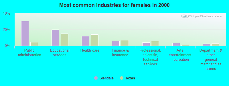
- Public administration (30.6%)
- Educational services (19.8%)
- Health care (11.8%)
- Finance & insurance (5.9%)
- Professional, scientific, technical services (3.8%)
- Arts, entertainment, recreation (3.5%)
- Department & other general merchandise stores (2.4%)
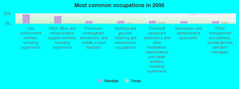
- Law enforcement workers, including supervisors (11.7%)
- Other office and administrative support workers, including supervisors (9.3%)
- Preschool, kindergarten, elementary, and middle school teachers (3.6%)
- Building and grounds cleaning and maintenance occupations (3.6%)
- Electrical equipment mechanics and other installation, maintenance, and repair workers, including supervisors (3.6%)
- Secretaries and administrative assistants (3.4%)
- Other management occupations, except farmers and farm managers (3.3%)
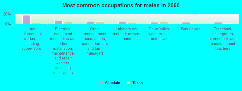
- Law enforcement workers, including supervisors (17.8%)
- Electrical equipment mechanics and other installation, maintenance, and repair workers, including supervisors (6.2%)
- Other management occupations, except farmers and farm managers (5.7%)
- Laborers and material movers, hand (5.4%)
- Driver/sales workers and truck drivers (3.9%)
- Bus drivers (3.6%)
- Preschool, kindergarten, elementary, and middle school teachers (3.4%)
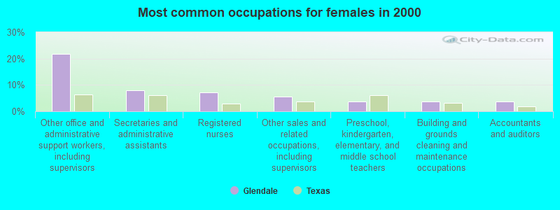
- Other office and administrative support workers, including supervisors (21.9%)
- Secretaries and administrative assistants (8.0%)
- Registered nurses (7.3%)
- Other sales and related occupations, including supervisors (5.6%)
- Preschool, kindergarten, elementary, and middle school teachers (3.8%)
- Building and grounds cleaning and maintenance occupations (3.8%)
- Accountants and auditors (3.8%)
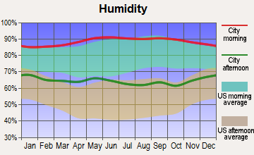
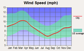
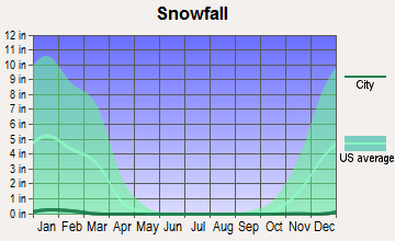
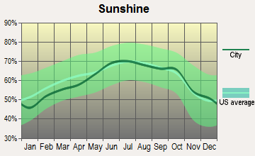
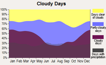
Average climate in Glendale, Texas
Based on data reported by over 4,000 weather stations


Tornado activity:
Glendale-area historical tornado activity is near Texas state average. It is 30% greater than the overall U.S. average.
On 5/16/1953, a category F3 (max. wind speeds 158-206 mph) tornado 22.1 miles away from the Glendale place center killed one person and injured 8 people.
On 1/19/1990, a category F3 tornado 27.5 miles away from the place center injured 2 people and caused between $500,000 and $5,000,000 in damages.
Earthquake activity:
Glendale-area historical earthquake activity is significantly above Texas state average. It is 256% greater than the overall U.S. average.On 5/17/2012 at 08:12:00, a magnitude 4.8 (4.8 MW, Depth: 3.1 mi, Class: Light, Intensity: IV - V) earthquake occurred 86.1 miles away from Glendale center
On 11/6/2011 at 03:53:10, a magnitude 5.7 (5.7 MW, Depth: 3.2 mi, Class: Moderate, Intensity: VI - VII) earthquake occurred 325.1 miles away from the city center
On 9/2/2013 at 23:51:15, a magnitude 4.3 (4.3 MW, Depth: 2.9 mi) earthquake occurred 83.0 miles away from the city center
On 9/2/2013 at 21:52:38, a magnitude 4.2 (4.2 MW, Depth: 3.0 mi) earthquake occurred 82.5 miles away from Glendale center
On 9/3/2016 at 12:02:44, a magnitude 5.8 (5.8 MW, Depth: 3.5 mi) earthquake occurred 387.2 miles away from the city center
On 10/20/2011 at 12:24:41, a magnitude 4.8 (4.8 MW, Depth: 3.1 mi) earthquake occurred 220.8 miles away from the city center
Magnitude types: moment magnitude (MW)
Natural disasters:
The number of natural disasters in Trinity County (19) is greater than the US average (15).Major Disasters (Presidential) Declared: 11
Emergencies Declared: 7
Causes of natural disasters: Floods: 8, Storms: 8, Hurricanes: 6, Tornadoes: 5, Fires: 2, Winds: 2, Winter Storm: 1, Other: 2 (Note: some incidents may be assigned to more than one category).
Colleges/universities with over 2000 students nearest to Glendale:
- Sam Houston State University (about 23 miles; Huntsville, TX; Full-time enrollment: 16,233)
- Angelina College (about 41 miles; Lufkin, TX; FT enrollment: 3,478)
- Lone Star College System (about 57 miles; The Woodlands, TX; FT enrollment: 45,205)
- Stephen F Austin State University (about 61 miles; Nacogdoches, TX; FT enrollment: 11,542)
- Texas A & M University-College Station (about 66 miles; College Station, TX; FT enrollment: 46,550)
- Universal Technical Institute of Texas Inc. (about 70 miles; Houston, TX; FT enrollment: 3,236)
- Prairie View A & M University (about 74 miles; Prairie View, TX; FT enrollment: 7,517)
Points of interest:
Notable location: Camp Ontologo (A). Display/hide its location on the map
Churches in Glendale include: Thornton Church (A), Zion Hill Church (B), White Rock Church (C), Pine Grove Baptist Church (D). Display/hide their locations on the map
Cemeteries: Foster Cemetery (1), Holly Cemetery (2), Anderson Cemetery (3), Glendale Cemetery (4), Saron Cemetery (5), White Rock Cemetery (6), New Zion Cemetery (7). Display/hide their locations on the map
Reservoirs: Sentell Lake (A), Haraldson Lake (B), Thornton Lake (C), Saron Lake Number 7 (D), Saron Lake Number 6 (E), Saron Lake Number 4 (F), Saron Lake Number 3 (G), Saron Lake Number 2 (H). Display/hide their locations on the map
Streams, rivers, and creeks: Baggy Branch (A), Turner Creek (B), Village Creek (C), Tantabogue Creek (D), Little White Rock Creek (E), Cedar Creek (F), Sandy Creek (G), Salt Creek (H), Dads Creek (I). Display/hide their locations on the map
Park in Glendale: Trilady Park (1). Display/hide its location on the map
| This place: | 2.4 people |
| Texas: | 2.8 people |
| This place: | 66.9% |
| Whole state: | 69.9% |
| This place: | 5.8% |
| Whole state: | 6.0% |
Likely homosexual households (counted as self-reported same-sex unmarried-partner households)
- Lesbian couples: 0.4% of all households
- Gay men: 0.3% of all households
| This place: | 16.0% |
| Whole state: | 15.4% |
| This place: | 3.6% |
| Whole state: | 6.7% |
For population 15 years and over in Glendale:
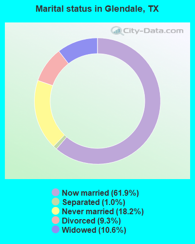
- Never married: 18.2%
- Now married: 61.9%
- Separated: 1.0%
- Widowed: 10.6%
- Divorced: 9.3%
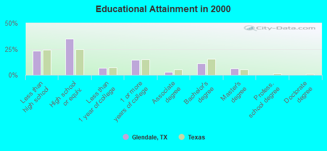
For population 25 years and over in Glendale:
- High school or higher: 76.9%
- Bachelor's degree or higher: 17.2%
- Graduate or professional degree: 6.2%
- Unemployed: 3.3%
- Mean travel time to work (commute): 30.6 minutes

| Here: | 12.3 |
| Texas average: | 15.6 |
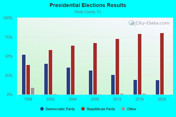
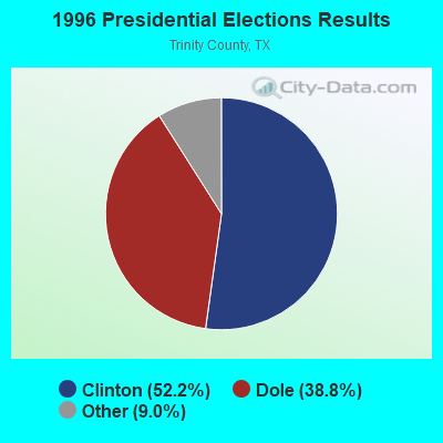
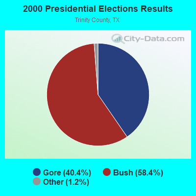
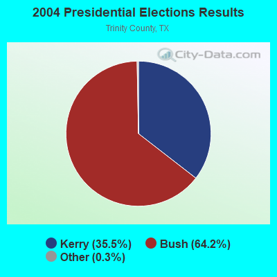
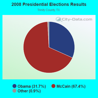
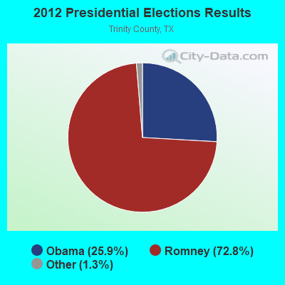

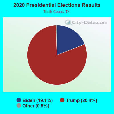
Graphs represent county-level data. Detailed 2008 Election Results
Religion statistics for Glendale, TX (based on Trinity County data)
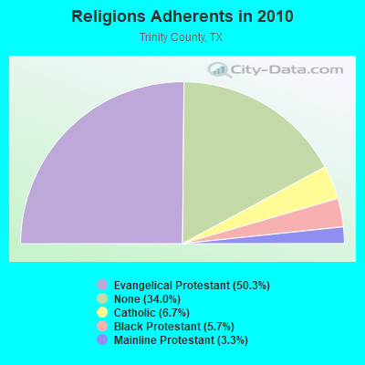
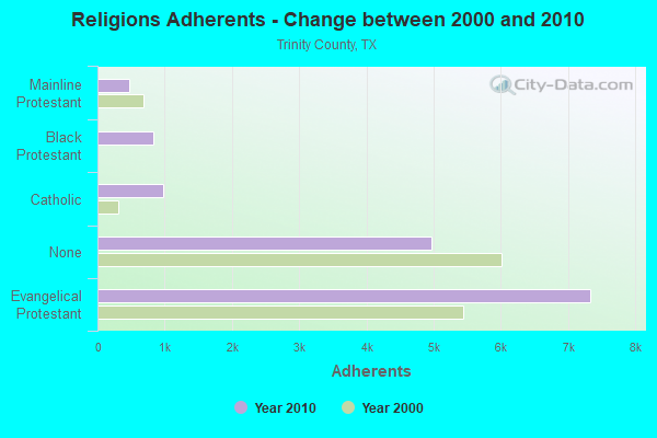
| Religion | Adherents | Congregations |
|---|---|---|
| Evangelical Protestant | 7,338 | 39 |
| Catholic | 973 | 1 |
| Black Protestant | 832 | 5 |
| Mainline Protestant | 480 | 3 |
| None | 4,962 | - |
Food Environment Statistics:
| Trinity County: | 2.12 / 10,000 pop. |
| Texas: | 1.47 / 10,000 pop. |
| This county: | 0.71 / 10,000 pop. |
| Texas: | 1.11 / 10,000 pop. |
| This county: | 5.66 / 10,000 pop. |
| State: | 3.95 / 10,000 pop. |
| Here: | 4.95 / 10,000 pop. |
| Texas: | 6.13 / 10,000 pop. |
| Trinity County: | 11.5% |
| Texas: | 8.9% |
| Trinity County: | 28.4% |
| Texas: | 26.6% |
| Trinity County: | 15.8% |
| Texas: | 15.7% |
Strongest AM radio stations in Glendale:
- KGOL (1180 AM; 50 kW; HUMBLE, TX; Owner: ENTRAVISION HOLDINGS, LLC)
- KTRH (740 AM; 50 kW; HOUSTON, TX; Owner: AMFM TEXAS LICENSES LIMITED PARTNERSHIP)
- KSEV (700 AM; 15 kW; TOMBALL, TX; Owner: LIBERMAN BROADCASTING OF HOUSTON LICENSE CORP.)
- KJOJ (880 AM; 10 kW; CONROE, TX; Owner: LIBERMAN BROADCASTING OF HOUSTON LICENSE CORP.)
- KETX (1440 AM; 5 kW; LIVINGSTON, TX; Owner: LONE STAR NETWORK)
- KIVY (1290 AM; 2 kW; CROCKETT, TX; Owner: LEON HUNT)
- KEEL (710 AM; 50 kW; SHREVEPORT, LA; Owner: CITICASTERS LICENSES, L.P.)
- KILE (1560 AM; 50 kW; BELLAIRE, TX; Owner: THE RAFTT CORPORATION)
- WBAP (820 AM; 50 kW; FORT WORTH, TX; Owner: WBAP-KSCS OPERATING, LTD.)
- KYOK (1140 AM; daytime; 5 kW; CONROE, TX; Owner: MARTIN BROADCASTING, INC.)
- KWKH (1130 AM; 50 kW; SHREVEPORT, LA; Owner: CITICASTERS LICENSES, L.P.)
- KZNE (1150 AM; 10 kW; COLLEGE STATION, TX; Owner: BRYAN BROADCASTING LICENSE SUBSIDIARY, INC.)
- KRLD (1080 AM; 50 kW; DALLAS, TX; Owner: TEXAS INFINITY BROADCASTING L.P.)
Strongest FM radio stations in Glendale:
- KTHT (97.1 FM; CLEVELAND, TX; Owner: CXR HOLDINGS, INC.)
- KVST (103.7 FM; WILLIS, TX; Owner: NEW WAVO COMMUNICATION GROUP, INC.)
- KUST (99.7 FM; HUNTSVILLE, TX; Owner: NEW WAVO COMMUNICATION GROUP, INC.)
- KHPT (106.9 FM; CONROE, TX; Owner: CXR HOLDINGS, INC.)
- KIVY-FM (92.7 FM; CROCKETT, TX; Owner: LEON HUNT)
- KETX-FM (92.3 FM; LIVINGSTON, TX; Owner: LONE STAR NETWORK)
- KAFX-FM (95.5 FM; DIBOLL, TX; Owner: CAPSTAR TX LIMITED PARTNERSHIP)
- KSAM-FM (101.7 FM; HUNTSVILLE, TX; Owner: HEH COMMUNICATIONS, LLC)
- KAXF (88.3 FM; CONROE, TX; Owner: AMERICAN FAMILY ASSOCIATION)
TV broadcast stations around Glendale:
- KBTX-TV (Channel 3; BRYAN, TX; Owner: KWTX-KBTX LICENSEE CORP.)
- KHTX-LP (Channel 30; HUNTSVILLE, TX; Owner: INTERNATIONAL BROADCASTING NETWORK)
- KHXL-LP (Channel 7; HUNTSVILLE, TX; Owner: INTERNATIONAL BROADCASTING NETWORK)
- KETX-LP (Channel 5; LIVINGSTON, TX; Owner: LONE STAR NETWORK)
- KTWC-LP (Channel 12; CROCKETT, TX; Owner: INTERNATIONAL BROADCASTING NETWORK)
- KCTL-LP (Channel 25; LIVINGSTON, TX; Owner: INTERNATIONAL BROADCASTING NETWORK)
- KIVY-LP (Channel 16; CROCKETT, TX; Owner: JIM GIBBS)
FCC Registered Antenna Towers:
8 (See the full list of FCC Registered Antenna Towers in Glendale)FCC Registered Microwave Towers:
3- Hawkins ENG, 1.28 Miles Ssw Of Intersection Of Tx Hwy. 14 & 2015, South (Lat: 32.540000 Lon: -95.220000), Type: Gtower, Structure height: 305 m, Overall height: 326.1 m, Call Sign: KA74750, Grant Date: 07/29/1981, Expiration Date: 08/01/2030, Registrant: Covington & Burling LLP, One Citycenter, 850 Tenth Street, N.W., Washington, DC 20001, Phone: (202) 662-5719, Fax: (202) 778-5719, Email:
- Hawkins Tower, 1.28 Miles Ssw Of Intersection Of Tx Hwy. 14 & 2015, South (Lat: 32.540000 Lon: -95.220000), Type: Tower, Structure height: 305 m, Overall height: 326.1 m, Call Sign: WLE948,
Assigned Frequencies: 7062.50 MHz, Grant Date: 10/24/1984, Expiration Date: 08/01/2030, Registrant: Covington & Burling LLP, One Citycenter, 850 Tenth Street, N.W., Washington, DC 20001, Phone: (202) 662-5719, Fax: (202) 778-5719, Email:
- Hawkins Tower, 1.28 Miles Ssw Of Intersection Of Tx Hwy. 14 & 2015, South (Lat: 32.540000 Lon: -95.220000), Type: Tower, Structure height: 305 m, Overall height: 326.1 m, Call Sign: WLO940,
Assigned Frequencies: 6962.50 MHz, Grant Date: 01/28/1992, Expiration Date: 08/01/2030, Registrant: Covington & Burling LLP, One Citycenter, 850 Tenth Street, N.W., Washington, DC 20001, Phone: (202) 662-5719, Fax: (202) 778-5719, Email:
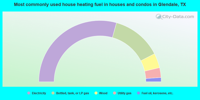
- 58.7%Electricity
- 26.2%Bottled, tank, or LP gas
- 7.7%Wood
- 5.2%Utility gas
- 2.2%Fuel oil, kerosene, etc.
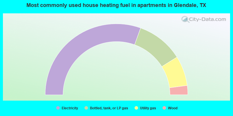
- 61.0%Electricity
- 21.2%Bottled, tank, or LP gas
- 13.6%Utility gas
- 4.2%Wood
Glendale compared to Texas state average:
- Median house value below state average.
- Unemployed percentage significantly below state average.
- Hispanic race population percentage significantly below state average.
- Median age significantly above state average.
- Foreign-born population percentage significantly below state average.
- Renting percentage below state average.
- Length of stay since moving in significantly above state average.
- Number of rooms per house significantly below state average.
- House age significantly below state average.
- Number of college students below state average.