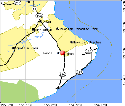
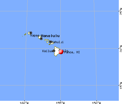
Pahoa, Hawaii
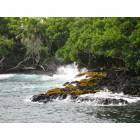
Pahoa: Isaac Hale Beach Park
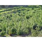
Pahoa: field of crip in pahoa
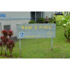
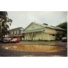
Pahoa: Affordable housing complex in Pahoa

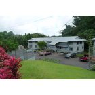
Pahoa: Front Yard Papai Street Pahoa Hawaii
Pahoa: Affordable housing complex in Pahoa
Pahoa: Akebono Theater Pahoa,Hawaii
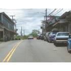
Pahoa: Downtown Pahoa
- add
your
Submit your own pictures of this place and show them to the world
- OSM Map
- General Map
- Google Map
- MSN Map
Population change since 2000: -1.8%
| Males: 475 | |
| Females: 470 |
| Median resident age: | 48.3 years |
| Hawaii median age: | 40.8 years |
Zip codes: 96778.
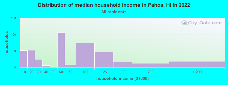
| Pahoa: | $53,260 |
| HI: | $92,458 |
Estimated per capita income in 2022: $22,336 (it was $13,850 in 2000)
Pahoa CDP income, earnings, and wages data
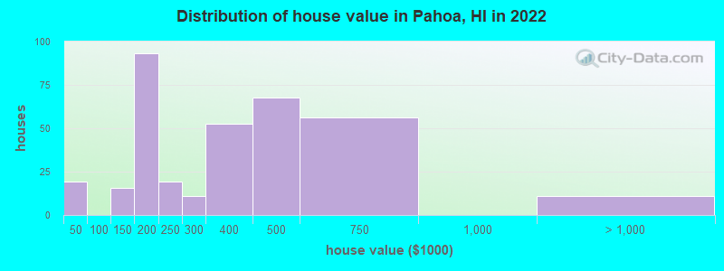
Estimated median house or condo value in 2022: $388,896 (it was $100,000 in 2000)
| Pahoa: | $388,896 |
| HI: | $820,100 |
Mean prices in 2022: all housing units: $334,752; detached houses: $338,075
(10.6% for White Non-Hispanic residents, 48.3% for Hispanic or Latino residents, 35.9% for Native Hawaiian and other Pacific Islander residents, 50.8% for two or more races residents)
Detailed information about poverty and poor residents in Pahoa, HI


Compare current foreclosures near Pahoa, HI:
| Photo | Address | Area | Beds / Baths | Price | Details |
|---|---|---|---|---|---|

|
#1
Ole Ole St
Pahoa, HI 96778
|
- sq. feet
|
2 baths 3 beds |
$413,010
|
show details |

|
#2
2 Lanai Street
Pahoa, HI 96778
|
720 sq. feet
|
1 baths 2 beds |
show details | |

|
#3
Seaview Road
Pahoa, HI 96778
|
855 sq. feet
|
1 baths 2 beds |
show details | |

|
#4
11th Avenue
Pahoa, HI 96778
|
- sq. feet
|
- baths - beds |
show details | |

|
#5
Pahoa Village Rd, Unit H1
Pahoa, HI 96778
|
- sq. feet
|
- baths - beds |
show details | |

|
#6
Pahoa Village Rd
Pahoa, HI 96778
|
- sq. feet
|
- baths - beds |
show details | |

|
#7
Malama St
Pahoa, HI 96778
|
- sq. feet
|
- baths - beds |
show details | |

|
#8
Kahukai St
Pahoa, HI 96778
|
- sq. feet
|
- baths - beds |
show details | |

|
#9
Pahoa Village Rd, Ste 203 Pmb 127
Pahoa, HI 96778
|
- sq. feet
|
- baths - beds |
show details | |

|
#10
Pahoa Village Rd, Ste 203 Pmb 241
Pahoa, HI 96778
|
- sq. feet
|
- baths - beds |
show details |
| Photo | Address | Area | Beds / Baths | Price | Details |
|---|---|---|---|---|---|

|
#11
King Kamehameha Blvd
Pahoa, HI 96778
|
- sq. feet
|
- baths - beds |
show details | |

|
#12
Kawakawa St
Pahoa, HI 96778
|
- sq. feet
|
- baths - beds |
show details | |

|
#13
Kinoole St
Hilo, HI 96720
|
1,263 sq. feet
|
2 baths 4 beds |
$299,900
|
show details |

|
#14
1986 9th Ave
Keaau, HI 96749
|
800 sq. feet
|
2 baths 2 beds |
show details | |

|
#15
Ainaola Dr
Hilo, HI 96720
|
1,536 sq. feet
|
1 baths 3 beds |
show details | |

|
#16
Naniakea St
Hilo, HI 96720
|
1,351 sq. feet
|
4 baths 8 beds |
show details | |

|
#17
Kapaka St
Hilo, HI 96720
|
1,776 sq. feet
|
2 baths 4 beds |
show details | |

|
#18
Komohana St
Hilo, HI 96720
|
1,367 sq. feet
|
2 baths 3 beds |
show details | |

|
#19
Hoaloha St
Hilo, HI 96720
|
1,568 sq. feet
|
2 baths 3 beds |
show details | |

|
#20
Kehaulani St
Hilo, HI 96720
|
3,394 sq. feet
|
4 baths 4 beds |
show details |
| Photo | Address | Area | Beds / Baths | Price | Details |
|---|---|---|---|---|---|

|
#21
Hookano St
Hilo, HI 96720
|
1,152 sq. feet
|
2 baths 6 beds |
show details | |

|
#22
Puhau St
Hilo, HI 96720
|
1,320 sq. feet
|
2 baths 3 beds |
show details | |

|
#23
Kaholo St
Hilo, HI 96720
|
2,060 sq. feet
|
3 baths 4 beds |
show details | |

|
#24
Alawaena St
Hilo, HI 96720
|
1,758 sq. feet
|
2 baths 2 beds |
show details | |

|
#25
Kilauea Ave
Hilo, HI 96720
|
- sq. feet
|
- baths - beds |
show details | |

|
#26
Iolani St Apt C
Hilo, HI 96720
|
- sq. feet
|
- baths - beds |
show details | |

|
#27
King Ave
Hilo, HI 96720
|
- sq. feet
|
- baths - beds |
show details | |

|
#28
Makoa Road
Mountain View, HI 96771
|
- sq. feet
|
- baths - beds |
show details | |

|
#29
Kupulau Rd Apt A
Hilo, HI 96720
|
- sq. feet
|
- baths - beds |
show details | |

|
#30
Kilauea Ave
Hilo, HI 96720
|
- sq. feet
|
- baths - beds |
show details |
| Photo | Address | Area | Beds / Baths | Price | Details |
|---|---|---|---|---|---|

|
#31
Delivery
Mountain View, HI 96771
|
- sq. feet
|
- baths - beds |
show details | |

|
#32
Delivery
Keaau, HI 96749
|
- sq. feet
|
- baths - beds |
show details | |

|
#33
Pahoa Rd, Ste. 111
Keaau, HI 96749
|
- sq. feet
|
- baths - beds |
show details | |

|
#34
N Ala Road
Mountain View, HI 96771
|
- sq. feet
|
- baths - beds |
show details | |

|
#35
Keaau Pahoa Rd, Ste 188 Pmb 435
Keaau, HI 96749
|
- sq. feet
|
- baths - beds |
show details | |

|
#36
Keaau Pahoa Rd, Ste 188 Pmb 748
Keaau, HI 96749
|
- sq. feet
|
- baths - beds |
show details | |

|
#37
Mamaka St
Keaau, HI 96749
|
- sq. feet
|
- baths - beds |
show details | |

|
#38
7th Ave
Keaau, HI 96749
|
- sq. feet
|
- baths - beds |
show details | |

|
#39
Kauhane Ave
Hilo, HI 96720
|
- sq. feet
|
- baths - beds |
show details | |

|
#40
Piilani St
Hilo, HI 96720
|
- sq. feet
|
- baths - beds |
show details |
| Photo | Address | Area | Beds / Baths | Price | Details |
|---|---|---|---|---|---|

|
Check over 1 million property listings on Foreclosure.com!
|
browse all offers | |||
| Photo | Address | Area | Beds / Baths | Price | Details |
|---|


- 50035.7%Asian alone
- 25017.9%White alone
- 24317.4%Hispanic
- 15711.2%Other race alone
- 1299.2%Two or more races
- 856.1%Native Hawaiian and Other
Pacific Islander alone
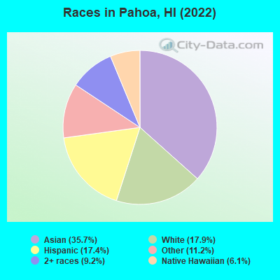
Races in Pahoa detailed stats: ancestries, foreign born residents, place of birth
According to our research of Hawaii and other state lists, there were 57 registered sex offenders living in Pahoa, Hawaii as of May 09, 2024.
The ratio of all residents to sex offenders in Pahoa is 13 to 1.
 Recent articles from our blog. Our writers, many of them Ph.D. graduates or candidates, create easy-to-read articles on a wide variety of topics.

 | Some questions about living here (14 replies) |
| Working and language in Hawaii (213 replies) |
| has America ruined Oahu? (45 replies) |
| Tropical weather - Flossie (67 replies) |
| How bad are bugs in Honolulu? (81 replies) |
| Why do people steal mopeds? (26 replies) |
Latest news from Pahoa, HI collected exclusively by city-data.com from local newspapers, TV, and radio stations
Ancestries: Irish (6.8%), Portuguese (3.5%).
Current Local Time: HST (no DST) time zone
Elevation: 655 feet
Land area: 2.27 square miles.
Population density: 417 people per square mile (low).
391 residents are foreign born (27.9% Asia).
| This place: | 27.9% |
| Hawaii: | 18.0% |
| Pahoa CDP: | 0.3% ($256) |
| Hawaii: | 0.3% ($765) |
Nearest city with pop. 50,000+: Honolulu, HI  (224.3 miles , pop. 371,657).
Nearest city with pop. 1,000,000+: Los Angeles, CA (2456.1 miles , pop. 3,694,820).
Nearest cities:
), Latitude: 19.50 N, Longitude: 154.95 W
Pahoa tourist attractions:
| Here: | 2.6% |
| Hawaii: | 2.9% |
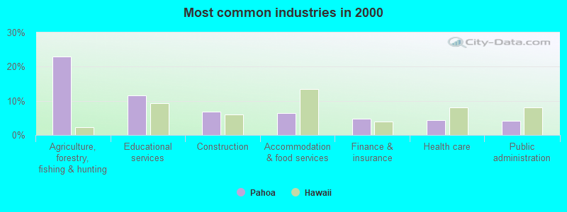
- Agriculture, forestry, fishing & hunting (23.0%)
- Educational services (11.5%)
- Construction (6.9%)
- Accommodation & food services (6.4%)
- Finance & insurance (4.7%)
- Health care (4.4%)
- Public administration (4.2%)
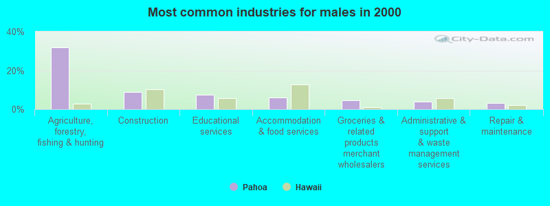
- Agriculture, forestry, fishing & hunting (31.7%)
- Construction (8.9%)
- Educational services (7.3%)
- Accommodation & food services (6.1%)
- Groceries & related products merchant wholesalers (4.5%)
- Administrative & support & waste management services (4.1%)
- Repair & maintenance (3.3%)
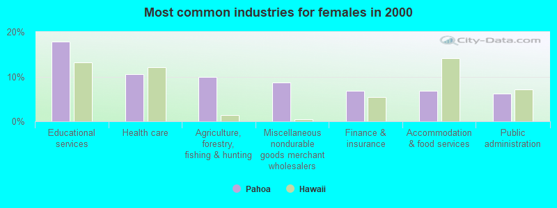
- Educational services (17.9%)
- Health care (10.5%)
- Agriculture, forestry, fishing & hunting (9.9%)
- Miscellaneous nondurable goods merchant wholesalers (8.6%)
- Finance & insurance (6.8%)
- Accommodation & food services (6.8%)
- Public administration (6.2%)
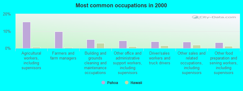
- Agricultural workers, including supervisors (15.4%)
- Farmers and farm managers (9.8%)
- Building and grounds cleaning and maintenance occupations (5.1%)
- Other office and administrative support workers, including supervisors (4.4%)
- Driver/sales workers and truck drivers (3.9%)
- Other sales and related occupations, including supervisors (3.7%)
- Other food preparation and serving workers, including supervisors (3.4%)
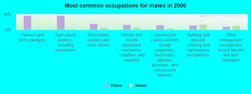
- Farmers and farm managers (15.0%)
- Agricultural workers, including supervisors (15.0%)
- Driver/sales workers and truck drivers (6.5%)
- Vehicle and mobile equipment mechanics, installers, and repairers (5.7%)
- Construction traders workers except carpenters, electricians, painters, plumbers, and construction laborers (5.3%)
- Building and grounds cleaning and maintenance occupations (4.9%)
- Other management occupations, except farmers and farm managers (3.7%)
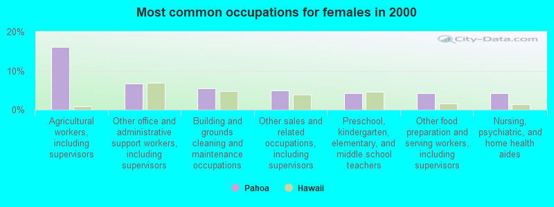
- Agricultural workers, including supervisors (16.0%)
- Other office and administrative support workers, including supervisors (6.8%)
- Building and grounds cleaning and maintenance occupations (5.6%)
- Other sales and related occupations, including supervisors (4.9%)
- Preschool, kindergarten, elementary, and middle school teachers (4.3%)
- Other food preparation and serving workers, including supervisors (4.3%)
- Nursing, psychiatric, and home health aides (4.3%)
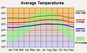
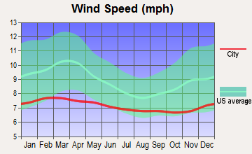
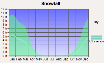
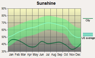
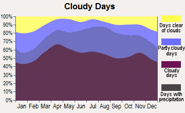
Average climate in Pahoa, Hawaii
Based on data reported by over 4,000 weather stations
(lower is better)
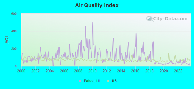
Air Quality Index (AQI) level in 2023 was 33.6. This is significantly better than average.
| City: | 33.6 |
| U.S.: | 72.6 |
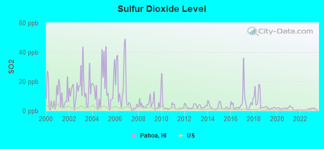
Sulfur Dioxide (SO2) [ppb] level in 2023 was 1.07. This is significantly better than average. Closest monitor was 3.6 miles away from the city center.
| City: | 1.07 |
| U.S.: | 1.51 |
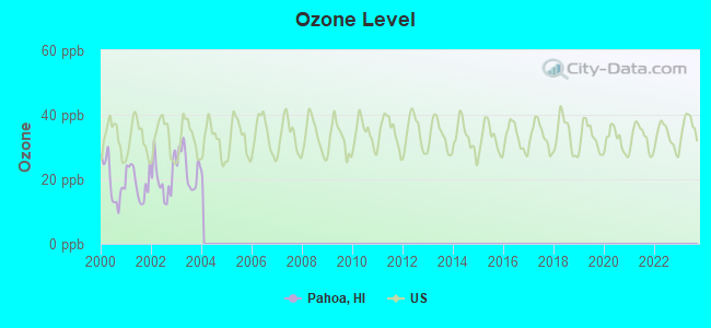
Ozone [ppb] level in 2003 was 23.5. This is significantly better than average. Closest monitor was 19.4 miles away from the city center.
| City: | 23.5 |
| U.S.: | 33.3 |
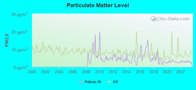
Particulate Matter (PM2.5) [µg/m3] level in 2023 was 2.79. This is significantly better than average. Closest monitor was 9.6 miles away from the city center.
| City: | 2.79 |
| U.S.: | 8.11 |
Earthquake activity:
Pahoa-area historical earthquake activity is significantly above Hawaii state average. It is 2659% greater than the overall U.S. average.On 11/29/1975 at 14:47:40, a magnitude 7.2 (6.0 MB, 7.1 MS, 7.2 UK, 7.2 MS, Class: Major, Intensity: VIII - XII) earthquake occurred 6.3 miles away from Pahoa center, causing 2 deaths (2 shaking deaths)
On 5/4/2018 at 22:32:54, a magnitude 6.9 (6.9 MW, Depth: 3.6 mi, Class: Strong, Intensity: VII - IX) earthquake occurred 13.0 miles away from the city center
On 8/21/1951 at 10:57:00, a magnitude 6.9 (6.9 UK) earthquake occurred 70.3 miles away from Pahoa center
On 11/16/1983 at 16:13:00, a magnitude 6.7 (6.4 MB, 6.7 MS, 6.7 MW) earthquake occurred 27.9 miles away from the city center, causing $6,000,000 total damage
On 10/15/2006 at 17:07:49, a magnitude 6.7 (6.7 MD, Depth: 23.7 mi) earthquake occurred 69.0 miles away from the city center
On 10/15/2006 at 17:07:49, a magnitude 6.7 (6.2 MB, 6.6 MS, 6.7 MW) earthquake occurred 72.0 miles away from the city center
Magnitude types: body-wave magnitude (MB), duration magnitude (MD), surface-wave magnitude (MS), moment magnitude (MW)
Natural disasters:
The number of natural disasters in Hawaii County (21) is greater than the US average (15).Major Disasters (Presidential) Declared: 11
Causes of natural disasters: Fires: 7, Earthquakes: 4, Floods: 3, Storms: 3, Volcanic Eruptions: 3, Hurricanes: 2, Lava Flows: 2, High Surf: 1, Mudslide: 1, Tropical Storm: 1, Tsunami Wave: 1, Other: 1 (Note: some incidents may be assigned to more than one category).
Colleges/universities with over 2000 students nearest to Pahoa:
- Hawaii Community College (about 17 miles; Hilo, HI; Full-time enrollment: 2,137)
- University of Hawaii at Hilo (about 17 miles; Hilo, HI; FT enrollment: 3,161)
- University of Hawaii Maui College (about 139 miles; Kahului, HI; FT enrollment: 2,492)
- Kapiolani Community College (about 222 miles; Honolulu, HI; FT enrollment: 5,069)
- Chaminade University of Honolulu (about 223 miles; Honolulu, HI; FT enrollment: 2,610)
- University of Hawaii at Manoa (about 224 miles; Honolulu, HI; FT enrollment: 16,461)
- Hawaii Pacific University (about 227 miles; Honolulu, HI; FT enrollment: 5,506)
Public high schools in Pahoa:
- PAHOA HIGH & INTERMEDIATE SCHOOL (Students: 717, Location: 15-3038 PUNA RD, Grades: 7-12)
- HAWAII ACADEMY OF ARTS & SCIENCE PCS (Students: 432, Location: 15-1397 HOMESTEAD RD, Grades: KG-12, Charter school)
- KUA O KA LA - PCS (Students: 125, Location: 14-5322 KAIMU-KAPOHO RD, Grades: KG-12, Charter school)
Public elementary/middle schools in Pahoa:
- KEONEPOKO ELEMENTARY SCHOOL (Students: 614, Location: 15-890 KAHAKAI BLVD, Grades: PK-6)
- PAHOA ELEMENTARY SCHOOL (Students: 410, Location: 15-3030 PUNA RD, Grades: PK-6)
Points of interest:
Notable location: Hawaii County Fire Department Station 10 Pahoa (A). Display/hide its location on the map
Hotels: Steam Vent Inn & Health Retreat (13-3775 Old Kalapana Road), Kalani Oceanside Retreat (12-6860 Kalapana-kapaho Rd), Yoga Oasis Retreat (PO Box 1935), Kapoho Paradise Vacation Rentals (14-5000 Laimana Ave), Lava Tree Tropic Inn (PO Box 1824).
Drinking water stations with addresses in Pahoa that have no violations reported:
- HAWAIIAN BEACHES (Population served: 3,430, Primary Water Source Type: Groundwater)
- HAWAIIAN SHORES (Population served: 1,310, Primary Water Source Type: Groundwater)
| This place: | 2.9 people |
| Hawaii: | 2.9 people |
| This place: | 68.2% |
| Whole state: | 68.9% |
| This place: | 7.5% |
| Whole state: | 7.3% |
Likely homosexual households (counted as self-reported same-sex unmarried-partner households)
- Lesbian couples: 1.2% of all households
- Gay men: 0.9% of all households
Banks with branches in Pahoa (2011 data):
- First Hawaiian Bank: Pahoa Branch at Government Main Rd, branch established on 1890/01/01. Info updated 2012/02/02: Bank assets: $15,830.2 mil, Deposits: $12,165.6 mil, headquarters in Honolulu, HI, positive income, 59 total offices, Holding Company: Bnp Paribas
- Bank of Hawaii: Pahoa Branch at Pahoa Govt. Road & Kauhale Stgreet, branch established on 1958/12/12. Info updated 2010/09/12: Bank assets: $13,868.5 mil, Deposits: $10,599.9 mil, headquarters in Honolulu, HI, positive income, Mortgage Lending Specialization, 71 total offices, Holding Company: Bank Of Hawaii Corporation
For population 15 years and over in Pahoa:
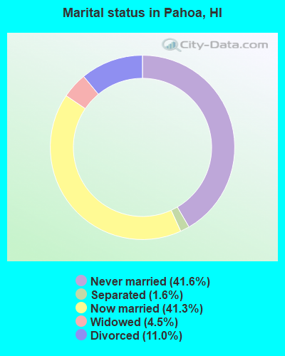
- Never married: 41.6%
- Now married: 41.3%
- Separated: 1.6%
- Widowed: 4.5%
- Divorced: 11.0%
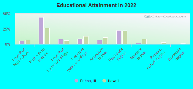
For population 25 years and over in Pahoa:
- High school or higher: 93.3%
- Bachelor's degree or higher: 24.8%
- Graduate or professional degree: 2.0%
- Unemployed: 6.0%
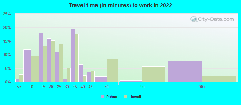
- Mean travel time to work (commute): 29.9 minutes
| Here: | 7.8 |
| Hawaii average: | 11.2 |
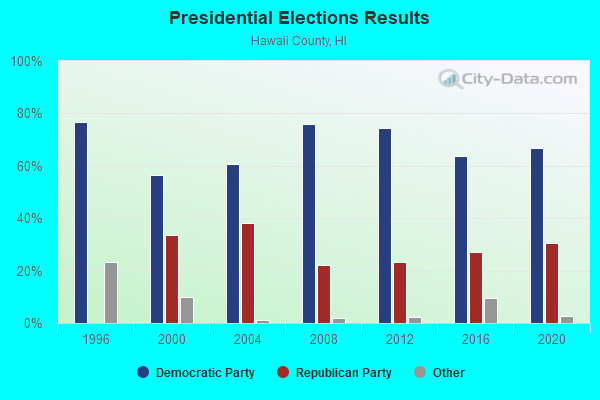
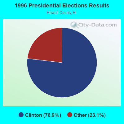
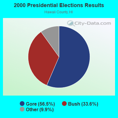
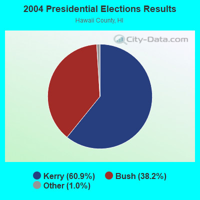

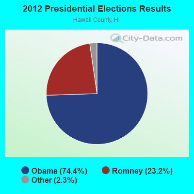
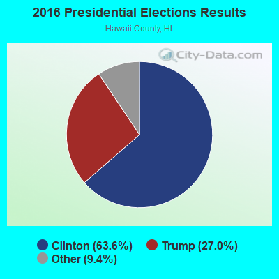
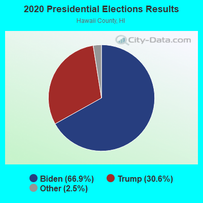
Graphs represent county-level data. Detailed 2008 Election Results
Neighborhoods in Pahoa:
(Pahoa, Hawaii Neighborhood Map)- Ahalanui Ahupua'a (Oneloa Ahupua'a) neighborhood
- Halepuaa Ahupua'a (Kanekiki Ahupua'a) neighborhood
- Honolulu Ahupua'a neighborhood
- Hulunanai Ahupua'a neighborhood
- Iliililoa Ahupua'a neighborhood
- Kaimu Ahupua'a (Makena Ahupua'a) neighborhood
- Kaimu-Makena Homesteads neighborhood
- Kalapana Ahupua'a (Kupahua Ahupua'a) neighborhood
- Kamaili Homesteads neighborhood
- Kaniahiku Homesteads neighborhood
- Kaohe Homesteads neighborhood
- Kapoho Ahupua'a neighborhood
- Kauaea Ahupua'a neighborhood
- Kaueleau Ahupua'a neighborhood
- Kauka Homesteads neighborhood
- Kaukulau Ahupua'a neighborhood
- Keahialaka Ahupua'a neighborhood
- Keauohana Ahupua'a (Keekee Ahupua'a) neighborhood
- Keauohana-Kehena-Keekee Homesteads neighborhood
- Keonepoko 1 Ahupua'a neighborhood
- Keonepoko 2 Ahupua'a neighborhood
- Keonepoko Homesteads neighborhood
- Kikala Ahupua'a (Keokea Ahupua'a) neighborhood
- Kikala-Keokea Homesteads neighborhood
- Kukuihala Ahupua'a (Kamaili Ahupua'a) neighborhood
- Kula Ahupua'a neighborhood
- Kupahua Homesteads neighborhood
- Makuu Ahupua'a neighborhood
- Malama Ahupua'a (Ki Ahupua'a) neighborhood
- Malama Homesteads neighborhood
- Nanawale Homesteads neighborhood
- Opihikao Ahupua'a neighborhood
- Opihikao Homesteads neighborhood
- Pohoiki Ahupua'a neighborhood
- Poupou Ahupua'a (Pulama Ahupua'a) neighborhood
- Pualaa Ahupua'a neighborhood
- Upper Kaimu Homesteads neighborhood
- Waawaa Ahupua'a neighborhood
- Waiakahiula Ahupua'a neighborhood
Religion statistics for Pahoa, HI (based on Hawaii County data)
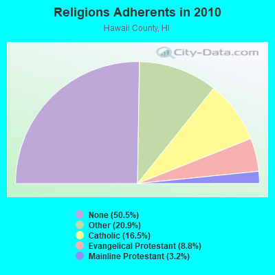
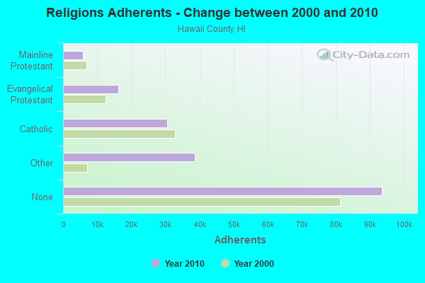
| Religion | Adherents | Congregations |
|---|---|---|
| Other | 38,701 | 88 |
| Catholic | 30,616 | 22 |
| Evangelical Protestant | 16,302 | 120 |
| Mainline Protestant | 5,882 | 43 |
| Orthodox | 25 | 1 |
| None | 93,553 | - |
Food Environment Statistics:
| Here: | 2.09 / 10,000 pop. |
| Hawaii: | 2.30 / 10,000 pop. |
| Hawaii County: | 0.06 / 10,000 pop. |
| Hawaii: | 0.09 / 10,000 pop. |
| This county: | 1.97 / 10,000 pop. |
| Hawaii: | 1.57 / 10,000 pop. |
| Hawaii County: | 2.55 / 10,000 pop. |
| Hawaii: | 1.72 / 10,000 pop. |
| This county: | 8.29 / 10,000 pop. |
| State: | 9.00 / 10,000 pop. |
| Hawaii County: | 7.1% |
| Hawaii: | 8.1% |
| Here: | 21.2% |
| Hawaii: | 20.8% |
| Hawaii County: | 10.3% |
| Hawaii: | 9.2% |
Health and Nutrition:
| Pahoa: | 55.8% |
| Hawaii: | 54.6% |
| Pahoa: | 51.1% |
| Hawaii: | 50.5% |
| Pahoa: | 26.1 |
| Hawaii: | 26.8 |
| Pahoa: | 17.8% |
| Hawaii: | 16.5% |
| Pahoa: | 19.0% |
| Hawaii: | 18.1% |
| Pahoa: | 6.8 |
| Hawaii: | 6.8 |
| This city: | 24.0% |
| Hawaii: | 26.1% |
| This city: | 55.6% |
| Hawaii: | 57.4% |
| Pahoa: | 80.9% |
| Hawaii: | 82.1% |
More about Health and Nutrition of Pahoa, HI Residents
5.92% of this county's 2021 resident taxpayers lived in other counties in 2020 ($88,163 average adjusted gross income)
| Here: | 5.92% |
| Hawaii average: | 4.91% |
0.03% of residents moved from foreign countries ($348 average AGI)
Hawaii County: 0.03% Hawaii average: 0.19%
Top counties from which taxpayers relocated into this county between 2020 and 2021:
| from Honolulu County, HI | |
| from Maui County, HI | |
| from Los Angeles County, CA |
4.50% of this county's 2020 resident taxpayers moved to other counties in 2021 ($58,837 average adjusted gross income)
| Here: | 4.50% |
| Hawaii average: | 5.53% |
0.03% of residents moved to foreign countries ($272 average AGI)
Hawaii County: 0.03% Hawaii average: 0.15%
Top counties to which taxpayers relocated from this county between 2020 and 2021:
| to Honolulu County, HI | |
| to Clark County, NV | |
| to Maui County, HI |
| Businesses in Pahoa, HI | ||||
| Name | Count | Name | Count | |
|---|---|---|---|---|
| 7-Eleven | 1 | FedEx | 1 | |
| Ace Hardware | 1 | UPS | 1 | |
| CVS | 1 | |||
Strongest AM radio stations in Pahoa:
- KPUA (670 AM; 10 kW; HILO, HI; Owner: NEW WEST BROADCASTING CORP.)
- KHLO (850 AM; 5 kW; HILO, HI; Owner: MAVERICK MEDIA OF HAWAII LICENSE, LLC)
- KIPA (620 AM; 10 kW; NAALEHU, HI; Owner: BIG ISLAND RADIO)
- KHBC (1060 AM; 5 kW; HILO, HI; Owner: HILO BROADCASTING, L.L.C.)
- KUAU (1570 AM; 50 kW; HAIKU, HI; Owner: FIRST ASSEMBLY OF GOD-KAHULUI, MAUI)
- KAIM (870 AM; 50 kW; HONOLULU, HI; Owner: SALEM MEDIA OF HAWAII, INC.)
- KKON (790 AM; 5 kW; KEALAKEKUA, HI; Owner: BIG ISLAND RADIO ( HAWAII LIMITED PA)
- KMVI (550 AM; 5 kW; WAILUKU, HI; Owner: PACIFIC RADIO GROUP,INC.)
- KNUI (900 AM; 5 kW; KAHULUI, HI; Owner: PACIFIC RADIO GROUP, INC.)
- KORL (690 AM; 10 kW; HONOLULU, HI; Owner: NEW WAVE BROADCASTING, L.P.)
- KAOI (1110 AM; 5 kW; KIHEI, HI; Owner: VISIONARY RELATED ENTERTAINMENT, INC)
- KGU (760 AM; 10 kW; HONOLULU, HI; Owner: SALEM MEDIA OF HAWAII, INC.)
- KHNR (650 AM; 10 kW; HONOLULU, HI; Owner: SALEM MEDIA OF HAWAII, INC.)
Strongest FM radio stations in Pahoa:
- KNUQ (103.7 FM; PAAUILO, HI; Owner: VISIONARY RELATED ENTERTAINMENT II,)
- KAGB (99.1 FM; WAIMEA, HI; Owner: BIG ISLAND RADIO)
- KLEO (106.1 FM; KAHALUU, HI; Owner: MAVERICK MEDIA OF HAWAII LICENSE, LLC)
- KLUA (93.9 FM; KAILUA KONA, HI; Owner: BIG ISLAND RADIO)
- KAOY (101.5 FM; KEALAKEKUA, HI; Owner: BIG ISLAND RADIO ( HAWAII LIMITED PA)
- KKOA (107.7 FM; VOLCANO, HI; Owner: MAVERICK MEDIA OF HAWAII LICENSE, LLC)
- KANO (91.1 FM; HILO, HI; Owner: HAWAII PUBLIC RADIO)
- KCIF (90.3 FM; HILO, HI; Owner: HILO CHRISTIAN BROADCASTING CORP.)
TV broadcast stations around Pahoa:
- KOIW-LP (Channel 16; MT. VIEW, HI; Owner: esi BROADCASTING CORPORATION)
- KGMD-TV (Channel 9; HILO, HI; Owner: EMMIS TELEVISION LICENSE CORPORATION)
- KWHH (Channel 14; HILO, HI; Owner: LESEA BROADCASTING CORPORATION)
- KHAW-TV (Channel 11; HILO, HI; Owner: EMMIS TELEVISION LICENSE CORPORATION)
- KHVO (Channel 13; HILO, HI; Owner: KITV HEARST-ARGYLE TV, INC. (CA CORP.))
- Pahoa, Hawaii
- Fatal accident count68
- Vehicles involved in fatal accidents94
- Fatal accidents involving drunk persons:41
- Fatalities74
- Persons involved in fatal accidents167
- Pedestrians involved in fatal accidents6
- Hawaii average
- Fatal accident count4037
- Vehicles involved in fatal accidents5798
- Fatal accidents involving drunk persons1777
- Fatalities4419
- Persons involved in fatal accidents10415
- Pedestrians involved in fatal accidents790
- National Bridge Inventory (NBI) Statistics
- 2Number of bridges
- 10ft / 3.1mTotal length
- $525,000Total costs
- 54,200Total average daily traffic
- 616Total average daily truck traffic
- 46,528Total future (year 2025) average daily traffic
FCC Registered Cell Phone Towers:
1 (See the full list of FCC Registered Cell Phone Towers in Pahoa)FCC Registered Antenna Towers:
66 (See the full list of FCC Registered Antenna Towers)FCC Registered Broadcast Land Mobile Towers:
2- 15 2730 Lai St (Lat: 19.542528 Lon: -154.910556), Call Sign: KKL404, Licensee ID: L00084628,
Assigned Frequencies: 153.560 MHz, Grant Date: 06/25/1997, Expiration Date: 08/31/2002, Cancellation Date: 04/25/2002, Registrant: Miller And Lieb Water Co Inc, Pahoa, HI 96778, Phone: (808) 965-9882
- Kapoho Substation, 4 Miles West Of (Lat: 19.481528 Lon: -154.899500), Type: Mast, Structure height: 12.2 m, Call Sign: WPYY786,
Assigned Frequencies: 456.793 MHz, Grant Date: 09/13/2023, Expiration Date: 12/03/2033, Certifier: Clyde H Nagata, Registrant: Utility Telecom Consulting Group, Inc., 1554 St. Paul Street, Denver, CO 80206, Phone: (303) 840-1041, Email:
FCC Registered Microwave Towers:
19 (See the full list of FCC Registered Microwave Towers in this town)FCC Registered Maritime Coast & Aviation Ground Towers:
2 (See the full list of FCC Registered Maritime Coast & Aviation Ground Towers)FCC Registered Amateur Radio Licenses:
203 (See the full list of FCC Registered Amateur Radio Licenses in Pahoa)FAA Registered Aircraft:
6- Aircraft: CESSNA 172C (Category: Land, Seats: 4, Weight: Up to 12,499 Pounds, Speed: 105 mph), Engine: CONT MOTOR 0-300 SER (145 HP) (Reciprocating)
N-Number: 1537Y, N1537Y, N-1537Y, Serial Number: 17249237, Year manufactured: 1962, Airworthiness Date: 03/16/1962, Certificate Issue Date: 07/23/2020
Registrant (Individual): Scott R Wilson, 15-2722 Kahala St, Pahoa, HI 96778 - Aircraft: CESSNA 150F (Category: Land, Seats: 2, Weight: Up to 12,499 Pounds, Speed: 90 mph), Engine: CONT MOTOR 0-200 SERIES (100 HP) (Reciprocating)
N-Number: 30LD, N30LD, N-30LD, Serial Number: 15063631, Year manufactured: 1966, Airworthiness Date: 04/01/1966, Certificate Issue Date: 02/11/2004
Registrant (Co-Owned): David D Jr Partlow, Po Box 555, Pahoa, HI 96778, Other Owners: Elaine S Partlow - Aircraft: HILLER UH-12B (Category: Land, Seats: 4, Weight: Up to 12,499 Pounds, Speed: 63 mph), Engine: FRANKLIN 6A4200 SERIES (200 HP) (Reciprocating)
N-Number: 539DC, N539DC, N-539DC, Serial Number: 539, Year manufactured: 1952, Airworthiness Date: 08/08/2000, Certificate Issue Date: 07/24/2018
Registrant (Individual): Marshall Leon Schmit, 12-135 E Moanauli Loop, Pahoa, HI 96778 - Aircraft: CESSNA 150E (Category: Land, Seats: 2, Weight: Up to 12,499 Pounds, Speed: 90 mph), Engine: CONT MOTOR 0-200 SERIES (100 HP) (Reciprocating)
N-Number: 6231R, N6231R, N-6231R, Serial Number: 15061531, Year manufactured: 1965, Airworthiness Date: 07/06/1965, Certificate Issue Date: 11/21/2011
Registrant (Co-Owned): David D Jr Partlow, Po Box 555, Pahoa, HI 96778, Other Owners: Elaine S Partlow - Aircraft: PIPER PA-28-151 (Category: Land, Seats: 4, Weight: Up to 12,499 Pounds, Speed: 80 mph), Engine: LYCOMING 0-320 SERIES (180 HP) (Reciprocating)
N-Number: 41282, N41282, N-41282, Serial Number: 28-7415158, Year manufactured: 1974, Airworthiness Date: 01/13/1974, Certificate Issue Date: 09/29/2008
Registrant (LLC): Wayforward LLC, Rr 2 Box 4515, Pahoa, HI 96778
Deregistered: Cancel Date: 01/18/2019 - Aircraft: WILDS WYMOND A 1 PASSENGER (Category: Land, Weight: Up to 12,499 Pounds), Engine: None
N-Number: 100SJ, N100SJ, N-100SJ, Serial Number: SJ-001, Certificate Issue Date: 01/22/2014
Registrant (Individual): Wymond A Wilds, 13-3556 Alapai St, Pahoa, HI 96778
Deregistered: Cancel Date: 03/09/2018
2003 - 2018 National Fire Incident Reporting System (NFIRS) incidents
- Fire incident types reported to NFIRS in Pahoa, HI
- 75049.1%Outside Fires
- 47731.2%Structure Fires
- 29919.6%Mobile Property/Vehicle Fires
- 20.1%Other
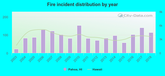 According to the data from the years 2003 - 2018 the average number of fire incidents per year is 96. The highest number of reported fires - 153 took place in 2010, and the least - 22 in 2003. The data has an increasing trend.
 When looking into fire subcategories, the most reports belonged to: Outside Fires (49.1%), and Structure Fires (31.2%).
- 75.8%No fuel used
- 13.8%Electricity
- 7.3%Other fuel
- 2.2%Bottled, tank, or LP gas
- 0.8%Solar energy
- 75.0%No fuel used
- 25.0%Electricity
Pahoa compared to Hawaii state average:
- Median household income below state average.
- Median house value below state average.
- Unemployed percentage below state average.
- Black race population percentage significantly below state average.
- Hispanic race population percentage above state average.
- Foreign-born population percentage above state average.
- Length of stay since moving in significantly above state average.
Pahoa on our top lists:
- #14 on the list of "Top 101 cities with the most residents born in Philippines (population 500+)"
- #23 on the list of "Top 101 cities with the most residents born in South Eastern Asia (population 500+)"
- #91 on the list of "Top 101 cities with the most residents born in Australia (population 500+)"
- #68 (96778) on the list of "Top 101 zip codes with the largest percentage of Portuguese first ancestries (pop 5,000+)"
- #1 on the list of "Top 101 counties with the highest Sulfur Oxides Annual air pollution readings in 2012 (µg/m3)"
- #27 on the list of "Top 101 counties with the lowest average weight of females"
- #50 on the list of "Top 101 counties with the highest percentage of residents that exercised in the past month"
- #59 on the list of "Top 101 counties with highest percentage of residents voting for Obama (Democrat) in the 2012 Presidential Election"
- #61 on the list of "Top 101 counties with the most Other congregations (pop. 50,000+)"

|
|
Total of 13 patent applications in 2008-2024.