Orchard, Idaho
Submit your own pictures of this place and show them to the world
- OSM Map
- General Map
- Google Map
- MSN Map

| Males: 10,848 | |
| Females: 7,272 |
| Median resident age: | 31.8 years |
| Idaho median age: | 33.2 years |
Zip code: 83650
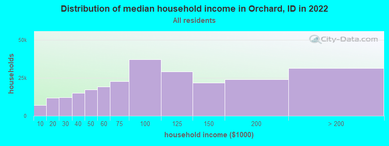
| Orchard: | $108,357 |
| ID: | $72,785 |
Estimated per capita income in 2022: $41,999 (it was $20,323 in 2000)
Orchard CCD income, earnings, and wages data
Estimated median house or condo value in 2022: $543,961 (it was $121,100 in 2000)
| Orchard: | $543,961 |
| ID: | $432,500 |
Mean prices in 2022: all housing units: $622,549; detached houses: $645,413; townhouses or other attached units: $461,873; in 2-unit structures: $640,491; in 3-to-4-unit structures: $328,636; in 5-or-more-unit structures: $733,042; mobile homes: $120,863
Detailed information about poverty and poor residents in Orchard, ID


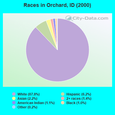
- 12,95687.8%White alone
- 9156.2%Hispanic
- 3192.2%Asian alone
- 2131.4%Two or more races
- 1591.1%American Indian alone
- 1491.0%Black alone
- 270.2%Other race alone
- 110.07%Native Hawaiian and Other
Pacific Islander alone
Races in Orchard detailed stats: ancestries, foreign born residents, place of birth
 Recent articles from our blog. Our writers, many of them Ph.D. graduates or candidates, create easy-to-read articles on a wide variety of topics.
Current Local Time: MST time zone
Elevation: 3150 feet
Land area: 662.8 square miles.
Population density: 27 people per square mile (very low).

| Orchard CCD: | 1.0% ($1,251) |
| Idaho: | 1.0% ($1,007) |
Nearest city with pop. 50,000+: Boise, ID  (19.2 miles , pop. 185,787).
Nearest city with pop. 200,000+: Northwest Clackamas, OR (346.0 miles , pop. 224,220).
Nearest city with pop. 1,000,000+: Los Angeles, CA (650.1 miles , pop. 3,694,820).
Nearest cities:
), )Latitude: 43.34 N, Longitude: 116.24 W
Area code commonly used in this area: 208

| Here: | 2.7% |
| Idaho: | 3.1% |
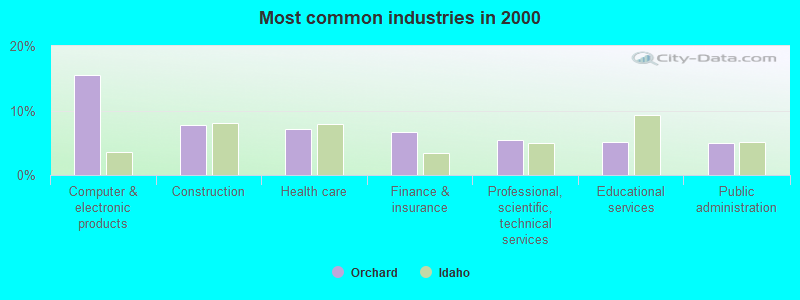
- Computer & electronic products (15.6%)
- Construction (7.8%)
- Health care (7.2%)
- Finance & insurance (6.6%)
- Professional, scientific, technical services (5.4%)
- Educational services (5.0%)
- Public administration (5.0%)
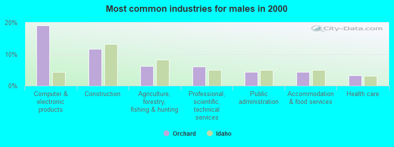
- Computer & electronic products (19.0%)
- Construction (11.6%)
- Agriculture, forestry, fishing & hunting (6.2%)
- Professional, scientific, technical services (6.0%)
- Public administration (4.4%)
- Accommodation & food services (4.4%)
- Health care (3.2%)
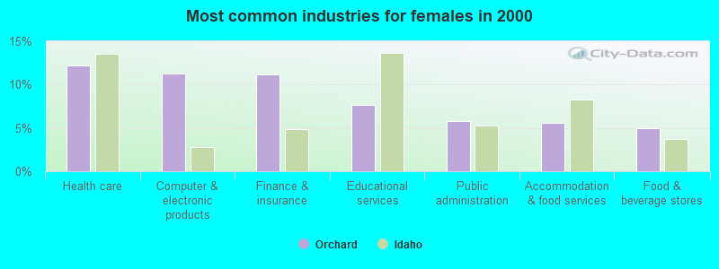
- Health care (12.2%)
- Computer & electronic products (11.2%)
- Finance & insurance (11.1%)
- Educational services (7.7%)
- Public administration (5.8%)
- Accommodation & food services (5.6%)
- Food & beverage stores (5.0%)
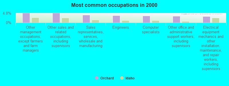
- Other management occupations, except farmers and farm managers (4.8%)
- Other sales and related occupations, including supervisors (4.8%)
- Sales representatives, services, wholesale and manufacturing (3.9%)
- Engineers (3.6%)
- Computer specialists (3.5%)
- Other office and administrative support workers, including supervisors (3.4%)
- Electrical equipment mechanics and other installation, maintenance, and repair workers, including supervisors (3.2%)
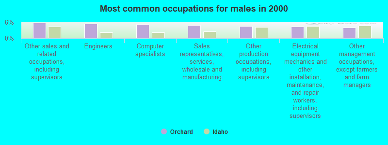
- Other sales and related occupations, including supervisors (5.8%)
- Engineers (5.5%)
- Computer specialists (5.2%)
- Sales representatives, services, wholesale and manufacturing (4.9%)
- Other production occupations, including supervisors (4.5%)
- Electrical equipment mechanics and other installation, maintenance, and repair workers, including supervisors (4.4%)
- Other management occupations, except farmers and farm managers (4.1%)
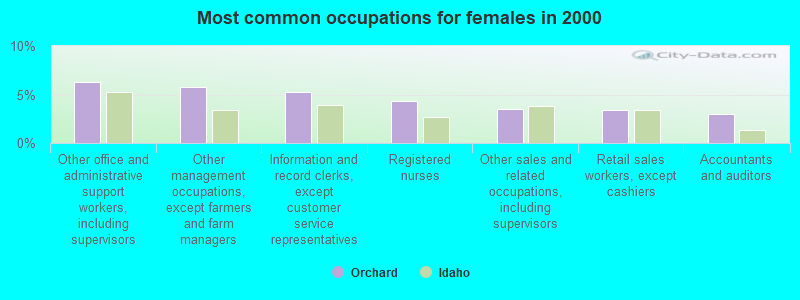
- Other office and administrative support workers, including supervisors (6.3%)
- Other management occupations, except farmers and farm managers (5.8%)
- Information and record clerks, except customer service representatives (5.3%)
- Registered nurses (4.3%)
- Other sales and related occupations, including supervisors (3.5%)
- Retail sales workers, except cashiers (3.4%)
- Accountants and auditors (3.0%)
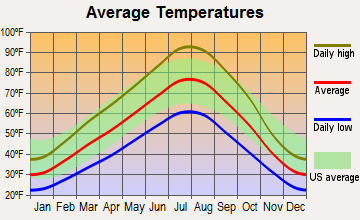
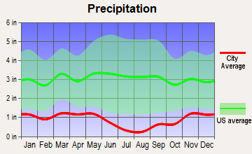
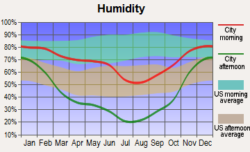
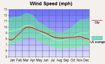
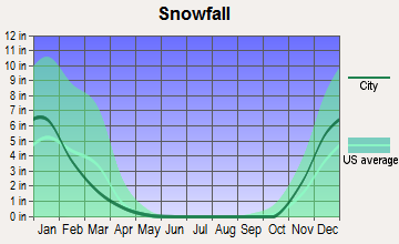
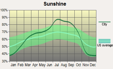
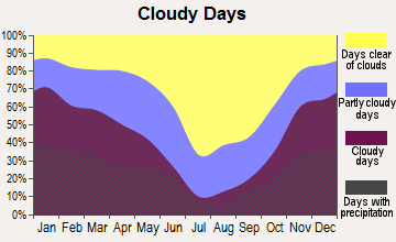
Average climate in Orchard, Idaho
Based on data reported by over 4,000 weather stations
(lower is better)
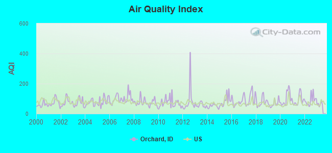
Air Quality Index (AQI) level in 2022 was 90.1. This is worse than average.
| City: | 90.1 |
| U.S.: | 72.6 |
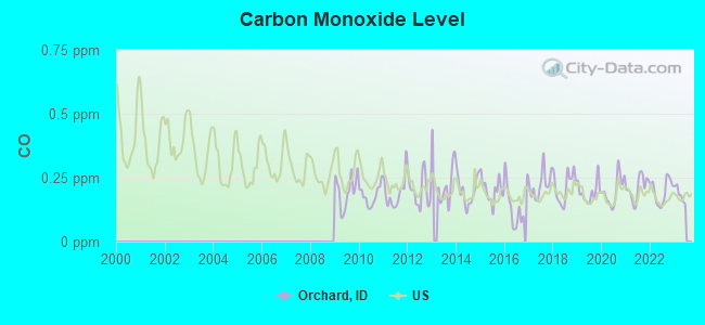
Carbon Monoxide (CO) [ppm] level in 2022 was 0.198. This is better than average. Closest monitor was 19.1 miles away from the city center.
| City: | 0.198 |
| U.S.: | 0.251 |
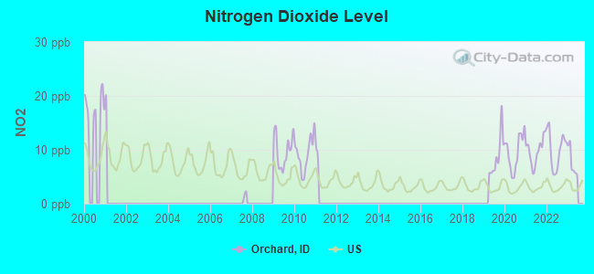
Nitrogen Dioxide (NO2) [ppb] level in 2022 was 9.98. This is significantly worse than average. Closest monitor was 19.1 miles away from the city center.
| City: | 9.98 |
| U.S.: | 5.11 |
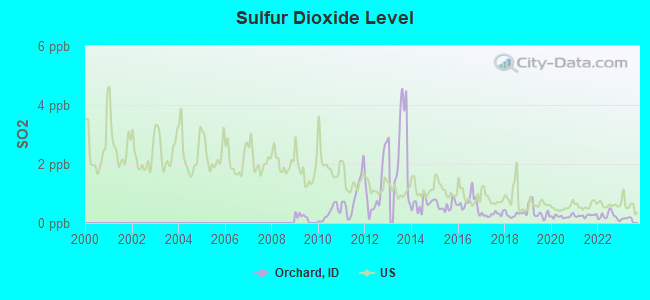
Sulfur Dioxide (SO2) [ppb] level in 2022 was 0.238. This is significantly better than average. Closest monitor was 19.1 miles away from the city center.
| City: | 0.238 |
| U.S.: | 1.515 |
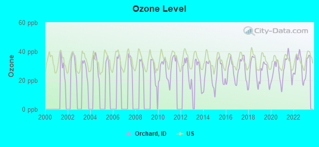
Ozone [ppb] level in 2022 was 29.7. This is about average. Closest monitor was 17.5 miles away from the city center.
| City: | 29.7 |
| U.S.: | 33.3 |
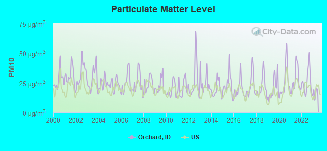
Particulate Matter (PM10) [µg/m3] level in 2022 was 26.6. This is worse than average. Closest monitor was 5.7 miles away from the city center.
| City: | 26.6 |
| U.S.: | 19.2 |
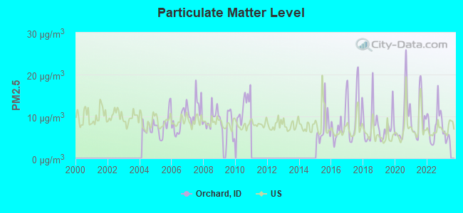
Particulate Matter (PM2.5) [µg/m3] level in 2022 was 8.31. This is about average. Closest monitor was 17.0 miles away from the city center.
| City: | 8.31 |
| U.S.: | 8.11 |
Earthquake activity:
Orchard-area historical earthquake activity is significantly above Idaho state average. It is 2315% greater than the overall U.S. average.On 10/28/1983 at 14:06:06, a magnitude 7.3 (6.2 MB, 7.3 MS, 7.0 MW, Class: Major, Intensity: VIII - XII) earthquake occurred 132.2 miles away from the city center, causing 2 deaths (2 shaking deaths) and 3 injuries, causing $15,000,000 total damage
On 10/3/1915 at 06:52:48, a magnitude 7.6 (7.6 UK) earthquake occurred 206.6 miles away from Orchard center
On 8/18/1959 at 06:37:13, a magnitude 7.7 (7.7 UK) earthquake occurred 290.7 miles away from the city center, causing $26,000,000 total damage
On 3/31/2020 at 23:52:30, a magnitude 6.5 (6.5 MW, Depth: 7.5 mi, Class: Strong, Intensity: VII - IX) earthquake occurred 96.0 miles away from Orchard center
On 12/16/1954 at 11:07:12, a magnitude 7.0 (7.0 UK) earthquake occurred 300.4 miles away from Orchard center
On 12/21/1932 at 06:10:09, a magnitude 7.2 (7.2 UK) earthquake occurred 347.5 miles away from the city center
Magnitude types: body-wave magnitude (MB), surface-wave magnitude (MS), moment magnitude (MW)
Natural disasters:
The number of natural disasters in Ada County (5) is a lot smaller than the US average (15).Major Disasters (Presidential) Declared: 2
Emergencies Declared: 1
Causes of natural disasters: Floods: 2, Fire: 1, Heavy Rain: 1, Hurricane: 1, Other: 1 (Note: some incidents may be assigned to more than one category).
Amtrak station near Orchard:
Colleges/universities with over 2000 students nearest to Orchard:
- Boise State University (about 19 miles; Boise, ID; Full-time enrollment: 16,774)
- Northwest Nazarene University (about 23 miles; Nampa, ID; FT enrollment: 2,290)
- College of Western Idaho (about 24 miles; Nampa, ID; FT enrollment: 6,300)
- Treasure Valley Community College (about 60 miles; Ontario, OR; FT enrollment: 2,055)
- College of Southern Idaho (about 104 miles; Twin Falls, ID; FT enrollment: 5,051)
- Eastern Oregon University (about 166 miles; La Grande, OR; FT enrollment: 3,127)
- Idaho State University (about 196 miles; Pocatello, ID; FT enrollment: 10,350)
Points of interest:
Notable locations in Orchard: Indian Creek Reservoir Public Fishing Area (A), Blacks Creek Rifle Range (B), Idaho State Correctional Institution (C), Bonneville Point Historical Site (D), Hickey (E), Kuna Rural Fire District Station 2 (F), Boise City Fire Department Station 12 Region 4 Hazardous Materials Team (G), Boise City Fire Department Station 22 (H). Display/hide their locations on the map
Lakes and reservoirs: Tadpole Lake (A), Wind Butte Lakes (B), Halverson Lake (C), Blacks Creek Reservoir (D), Indian Creek Reservoir (E). Display/hide their locations on the map
Streams, rivers, and creeks: Charcoal Creek (A), Bryans Run (B), Birch Creek (C), Sand Creek (D), Sheep Creek (E), Bowns Creek (F), Blacks Creek (G), Mores Creek (H). Display/hide their locations on the map
Parks in Orchard include: Lucky Peak State Recreation Area (1), Snake River Bird of Prey Natural Area (2), Barclay Bay Picnic Area (3). Display/hide their locations on the map
| This place: | 2.7 people |
| Idaho: | 2.7 people |
| This place: | 74.3% |
| Whole state: | 69.6% |
| This place: | 5.5% |
| Whole state: | 6.3% |
Likely homosexual households (counted as self-reported same-sex unmarried-partner households)
- Lesbian couples: 0.5% of all households
- Gay men: 0.2% of all households
| This place: | 5.9% |
| Whole state: | 11.8% |
| This place: | 2.4% |
| Whole state: | 4.6% |
100 people in correctional residential facilities in 2010
People in group quarters in Orchard in 2000:
- 2,451 people in state prisons
- 84 people in halfway houses
- 7 people in agriculture workers' dormitories on farms
For population 15 years and over in Orchard:
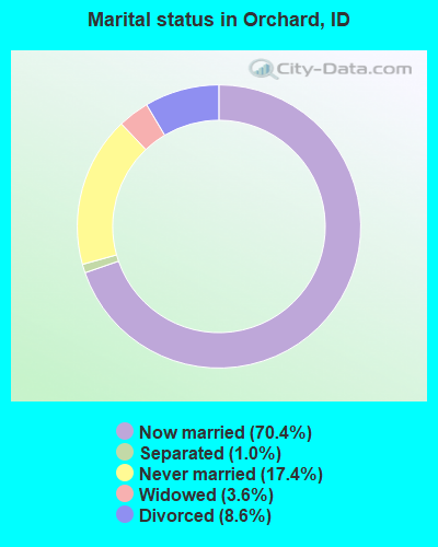
- Never married: 17.4%
- Now married: 70.4%
- Separated: 1.0%
- Widowed: 3.6%
- Divorced: 8.6%
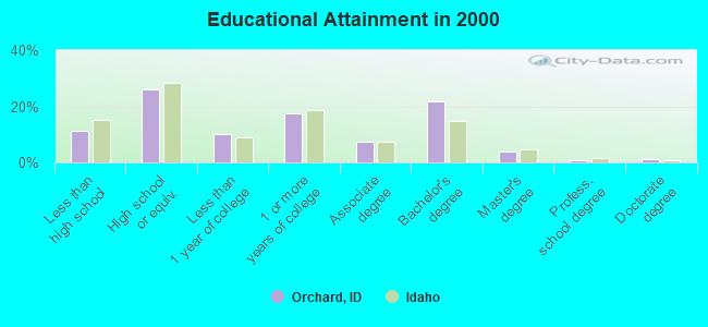
For population 25 years and over in Orchard:
- High school or higher: 88.7%
- Bachelor's degree or higher: 27.8%
- Graduate or professional degree: 6.0%
- Unemployed: 3.1%
- Mean travel time to work (commute): 18.0 minutes
| Here: | 9.9 |
| Idaho average: | 11.1 |
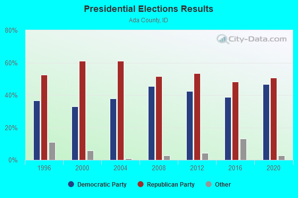
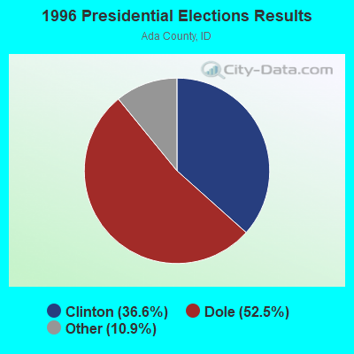
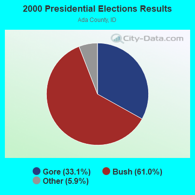
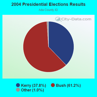
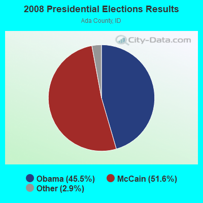
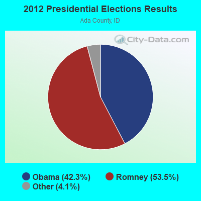
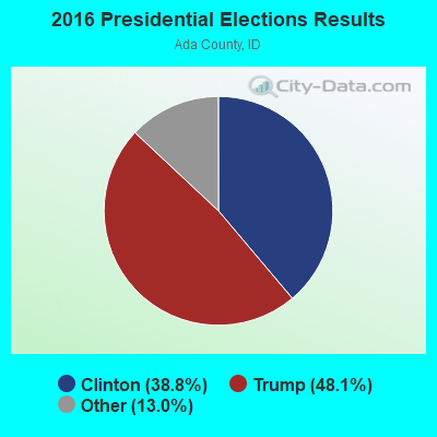
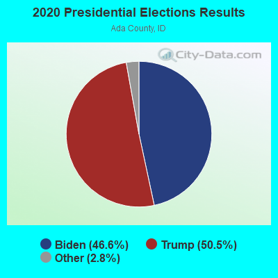
Graphs represent county-level data. Detailed 2008 Election Results
Religion statistics for Orchard, ID (based on Ada County data)
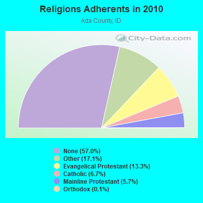
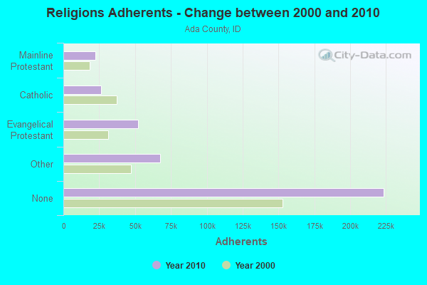
| Religion | Adherents | Congregations |
|---|---|---|
| Other | 67,288 | 156 |
| Evangelical Protestant | 52,126 | 147 |
| Catholic | 26,302 | 9 |
| Mainline Protestant | 22,441 | 37 |
| Orthodox | 420 | 4 |
| Black Protestant | 252 | 2 |
| None | 223,536 | - |
Food Environment Statistics:
| Ada County: | 1.23 / 10,000 pop. |
| Idaho: | 1.88 / 10,000 pop. |
| Ada County: | 0.27 / 10,000 pop. |
| Idaho: | 0.28 / 10,000 pop. |
| Ada County: | 0.19 / 10,000 pop. |
| State: | 0.53 / 10,000 pop. |
| Ada County: | 2.65 / 10,000 pop. |
| Idaho: | 3.87 / 10,000 pop. |
| Here: | 7.80 / 10,000 pop. |
| Idaho: | 7.75 / 10,000 pop. |
| Ada County: | 6.7% |
| Idaho: | 7.7% |
| Ada County: | 22.1% |
| State: | 25.7% |
| Ada County: | 10.1% |
| State: | 11.7% |
8.72% of this county's 2021 resident taxpayers lived in other counties in 2020 ($85,598 average adjusted gross income)
| Here: | 8.72% |
| Idaho average: | 9.53% |
0.03% of residents moved from foreign countries ($213 average AGI)
Ada County: 0.03% Idaho average: 0.03%
Top counties from which taxpayers relocated into this county between 2020 and 2021:
| from Canyon County, ID | |
| from Orange County, CA | |
| from Los Angeles County, CA |
7.23% of this county's 2020 resident taxpayers moved to other counties in 2021 ($67,504 average adjusted gross income)
| Here: | 7.23% |
| Idaho average: | 7.66% |
0.02% of residents moved to foreign countries ($112 average AGI)
Ada County: 0.02% Idaho average: 0.02%
Top counties to which taxpayers relocated from this county between 2020 and 2021:
| to Canyon County, ID | |
| to Maricopa County, AZ | |
| to Elmore County, ID |
Strongest AM radio stations in Orchard:
- KBOI (670 AM; 50 kW; BOISE, ID; Owner: CITADEL BROADCASTING COMPANY)
- KBSU (730 AM; 15 kW; BOISE, ID; Owner: IDAHO STATE BOARD OF EDUCATION)
- KFXD (630 AM; 5 kW; BOISE, ID; Owner: CITICASTERS LICENSES, L.P.)
- KGEM (1140 AM; 10 kW; BOISE, ID; Owner: JOURNAL BROADCAST CORPORATION)
- KIDO (580 AM; 5 kW; NAMPA, ID; Owner: CITICASTERS LICENSES, L.P.)
- KTIK (1350 AM; 5 kW; NAMPA, ID; Owner: CITADEL BROADCASTING COMPANY)
- KBGN (1060 AM; daytime; 10 kW; CALDWELL, ID; Owner: NELSON M. AND KAREN E. WILSON)
- KWEI (1260 AM; 50 kW; WEISER, ID; Owner: TREASURE VALLEY BROADCASTING CO.)
- KKIC (950 AM; 4 kW; BOISE, ID; Owner: WESTERN PACIFIC, INC)
- KSPD (790 AM; 1 kW; BOISE, ID; Owner: KSPD, INC.)
- KSRV (1380 AM; 5 kW; ONTARIO, OR; Owner: HBG-RADIO ONTARIO LLC)
- KMHI (1240 AM; 1 kW; MOUNTAIN HOME, ID; Owner: AGM-IDAHO BROADCASTING, LLC)
- KALL (700 AM; 50 kW; NORTH SALT LAKE CITY, UT; Owner: CITICASTERS LICENSES, L.P.)
Strongest FM radio stations in Orchard:
- KBSX (91.5 FM; BOISE, ID; Owner: IDAHO STATE BOARD OF EDUCATION)
- KIZN (92.3 FM; BOISE, ID; Owner: CITADEL BROADCASTING COMPANY)
- KKGL (96.9 FM; NAMPA, ID; Owner: CITADEL BROADCASTING COMPANY)
- KQFC (97.9 FM; BOISE, ID; Owner: CITADEL BROADCASTING COMPANY)
- KZMG (93.1 FM; NEW PLYMOUTH, ID; Owner: CITADEL BROADCASTING COMPANY)
- KBSU-FM (90.3 FM; BOISE, ID; Owner: IDAHO STATE BOARD OF EDUCATION)
- KCIX (105.9 FM; GARDEN CITY, ID; Owner: CITICASTERS LICENSES, L.P.)
- KRVB (94.9 FM; NAMPA, ID; Owner: JOURNAL BROADCAST CORPORATION)
- KXLT-FM (107.9 FM; EAGLE, ID; Owner: CITICASTERS LICENSES, L.P.)
- KJOT (105.1 FM; BOISE, ID; Owner: JOURNAL BROADCAST CORPORATION)
- KTHI (107.1 FM; CALDWELL, ID; Owner: JOURNAL BROADCAST CORPORATION)
- KBXL (94.1 FM; CALDWELL, ID; Owner: KSPD, INC.)
- KTSY (89.5 FM; CALDWELL, ID; Owner: GEM STATE ADVENTIST ACADEMY)
- KSAS-FM (103.3 FM; CALDWELL, ID; Owner: CITICASTERS LICENSES, L.P.)
- KLTB (104.3 FM; BOISE, ID; Owner: CITICASTERS LICENSES, L.P.)
- KJHY (101.9 FM; EMMETT, ID; Owner: CAPITAL WEST INC)
- K239AC (95.7 FM; GARDEN CITY, ID; Owner: CALVARY CHAPEL OF TWIN FALLS, INC.)
- KTPZ (99.1 FM; MOUNTAIN HOME, ID; Owner: AGM-IDAHO BROADCASTING, LLC)
- KWEI-FM (99.5 FM; FRUITLAND, ID; Owner: TREASURE VALLEY BROADCASTING CO.)
- KARO (98.7 FM; NYSSA, OR; Owner: EDUCATIONAL MEDIA FOUNDATION)
TV broadcast stations around Orchard:
- KTRV (Channel 12; NAMPA, ID; Owner: IDAHO INDEPENDENT TELEVISION, INC.)
- K35GE (Channel 35; BOISE, ID; Owner: EQUITY BROADCASTING CORPORATION)
- K30GS (Channel 30; BOISE, ID; Owner: MS COMMUNICATIONS, LLC)
FCC Registered Cell Phone Towers:
1- 9.58 Miles Sw Of Orchard, Id (Lat: 43.282111 Lon: -116.212056), Type: Tower, Structure height: 30.5 m, Overall height: 34.1 m, Call Sign: KNKA490
Assigned Frequencies: 880.020 MHz, 835.020 MHz, 891.510 MHz, 846.510 MHzGrant Date: 12/19/2017, Expiration Date: 01/22/2028, Certifier: Gregory M RomanoRegistrant: Verizon, 1300 I St Nw - Suite 500 East, Washington, DC 20005, Phone: (202) 515-2453, Email:
FCC Registered Microwave Towers:
2- BOIXMASMTN, 9.58 Mi Sw Of Orchard (Lat: 43.282111 Lon: -116.212028), Type: Mast, Structure height: 18.3 m, Overall height: 21.9 m, Call Sign: WMN668,
Assigned Frequencies: 10775.0 MHz, 10755.0 MHz, 10875.0 MHz, Grant Date: 01/26/2021, Expiration Date: 02/01/2031, Certifier: Gregory M Romano, Registrant: Verizon, 1300 I St Nw - Suite 500 East, Washington, DC 20005, Phone: (202) 515-2453, Email:
- ORCHARD, ID, Various Locations (Lat: 43.282500 Lon: -116.211667), Overall height: 6.1 m, Call Sign: WNTW975,
Assigned Frequencies: 956.331 MHz, 956.331 MHz, 956.331 MHz, Grant Date: 01/22/2020, Expiration Date: 04/06/2030, Registrant: Intermountain Gas Company, 555 S. Cole Road, Boise, ID 83709, Phone: (208) 377-6099, Fax: (208) 377-6169, Email:
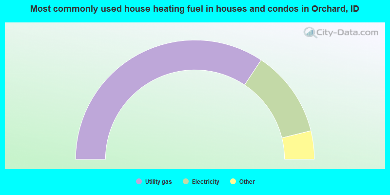
- 68.7%Utility gas
- 23.6%Electricity
- 3.4%Wood
- 2.0%Bottled, tank, or LP gas
- 1.6%Fuel oil, kerosene, etc.
- 0.7%Other fuel
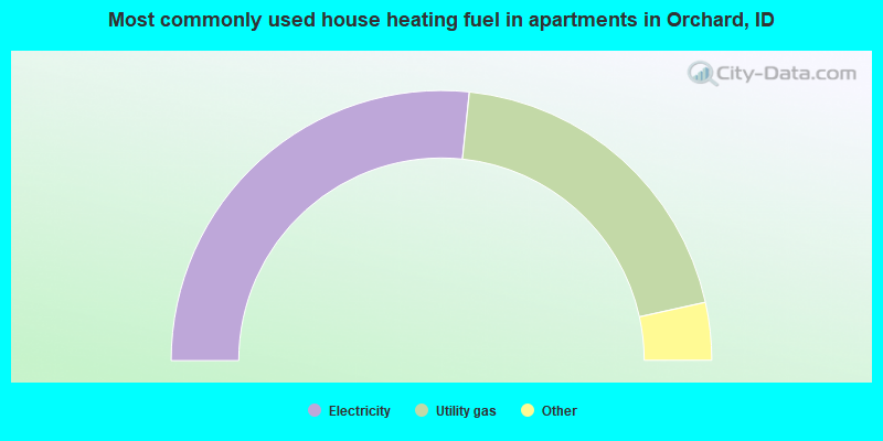
- 53.3%Electricity
- 39.8%Utility gas
- 3.6%Bottled, tank, or LP gas
- 2.8%Fuel oil, kerosene, etc.
- 0.3%Coal or coke
- 0.3%Wood
Orchard compared to Idaho state average:
- Unemployed percentage significantly below state average.
- Black race population percentage above state average.
- Hispanic race population percentage below state average.
- Median age significantly below state average.
- Foreign-born population percentage significantly below state average.
- Length of stay since moving in significantly above state average.
- Number of rooms per house significantly below state average.
- House age significantly below state average.
- Institutionalized population percentage significantly above state average.
Orchard on our top lists:
- #4 on the list of "Top 101 cities with largest percentage of males in industries: computer and electronic products (population 5,000+)"
- #5 on the list of "Top 101 cities with largest percentage of females in industries: computer and electronic products (population 5,000+)"
- #19 on the list of "Top 101 cities with largest percentage of females in industries: wood products (population 5,000+)"
- #20 on the list of "Top 101 cities with largest percentage of females in occupations: other financial specialists (population 5,000+)"
- #21 on the list of "Top 101 cities with largest percentage of males in occupations: drafters, engineering, and mapping technicians (population 5,000+)"
- #22 on the list of "Top 101 cities with largest percentage of females in occupations: electrical equipment mechanics and other installation, maintenance, and repair occupations including supervisors (population 5,000+)"
- #29 on the list of "Top 101 cities with the largest percentage of people in halfway houses (population 1,000+)"
- #30 on the list of "Top 101 cities with largest percentage of males in occupations: air transportation workers (population 5,000+)"
- #31 on the list of "Top 101 cities with largest percentage of females in industries: water transportation (population 5,000+)"
- #35 on the list of "Top 101 cities with largest percentage of females in industries: alcoholic beverages merchant wholesalers (population 5,000+)"
- #41 on the list of "Top 101 cities with largest percentage of males in industries: other direct selling establishments (population 5,000+)"
- #50 on the list of "Top 101 cities with largest percentage of males in occupations: therapists (population 5,000+)"
- #52 on the list of "Top 101 cities with largest percentage of males in industries: hardware, plumbing and heating equipment, and supplies merchant wholesalers (population 5,000+)"
- #61 on the list of "Top 101 cities with largest percentage of females in occupations: metal workers and plastic workers (population 5,000+)"
- #62 on the list of "Top 101 cities with largest percentage of females in industries: sporting goods, camera, and hobby and toy stores (population 5,000+)"
- #63 on the list of "Top 100 cities with the largest percentage of males (pop. 5,000+)"
- #72 on the list of "Top 101 cities with largest percentage of males in industries: food (population 5,000+)"
- #77 on the list of "Top 100 cities with largest land areas (pop. 5,000+)"
- #95 on the list of "Top 101 cities with largest percentage of males in industries: leather and allied products (population 5,000+)"
- #20 on the list of "Top 101 counties with the highest percentage of residents that exercised in the past month"
- #26 on the list of "Top 101 counties with the largest decrease in the number of infant deaths per 1000 residents 2000-2006 to 2007-2013 (pop. 50,000+)"
- #27 on the list of "Top 101 counties with highest percentage of residents voting for 3rd party candidates in the 2012 Presidential Election (pop. 50,000+)"
- #29 on the list of "Top 101 counties with the most Other congregations"
- #30 on the list of "Top 101 counties with the highest percentage of residents that keep firearms around their homes"