North Atoka, Oklahoma
Submit your own pictures of this place and show them to the world
- OSM Map
- General Map
- Google Map
- MSN Map

| Males: 1,561 | |
| Females: 753 |
| Median resident age: | 38.1 years |
| Oklahoma median age: | 35.5 years |
Zip code: 74569
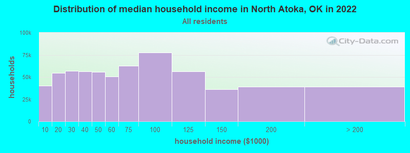
| North Atoka: | $51,273 |
| OK: | $59,673 |
Estimated per capita income in 2022: $23,899 (it was $12,437 in 2000)
North Atoka CCD income, earnings, and wages data
Estimated median house or condo value in 2022: $125,044 (it was $45,300 in 2000)
| North Atoka: | $125,044 |
| OK: | $191,700 |
Detailed information about poverty and poor residents in North Atoka, OK


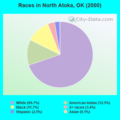
- 1,54569.7%White alone
- 27612.5%American Indian alone
- 26011.7%Black alone
- 753.4%Two or more races
- 552.5%Hispanic
- 30.1%Asian alone
- 20.09%Native Hawaiian and Other
Pacific Islander alone
Races in North Atoka detailed stats: ancestries, foreign born residents, place of birth
 Recent articles from our blog. Our writers, many of them Ph.D. graduates or candidates, create easy-to-read articles on a wide variety of topics.
Current Local Time: CST time zone
Land area: 363.5 square miles.
Population density: 6.4 people per square mile (very low).

| North Atoka CCD: | 0.4% ($199) |
| Oklahoma: | 0.8% ($523) |
Nearest city with pop. 50,000+: East Grayson, TX (71.6 miles  , pop. 81,381).
Nearest city with pop. 200,000+: Tulsa, OK (110.3 miles , pop. 393,049).
Nearest city with pop. 1,000,000+: Dallas, TX (129.6 miles , pop. 1,188,580).
Nearest cities:
), ), ), ), Latitude: 34.54 N, Longitude: 95.94 W
Area code commonly used in this area: 580

| Here: | 3.8% |
| Oklahoma: | 3.2% |
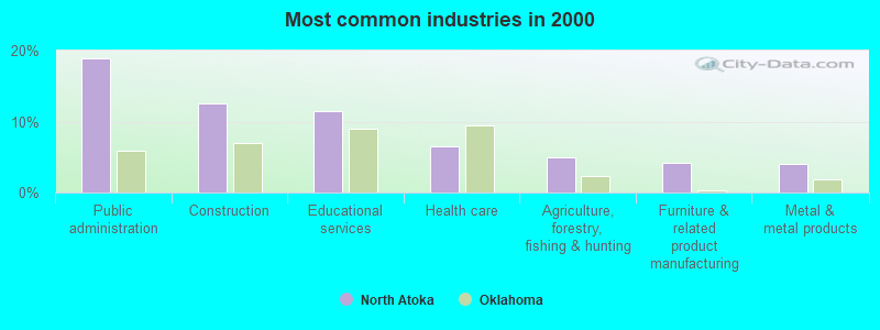
- Public administration (19.0%)
- Construction (12.5%)
- Educational services (11.5%)
- Health care (6.4%)
- Agriculture, forestry, fishing & hunting (4.9%)
- Furniture & related product manufacturing (4.2%)
- Metal & metal products (4.1%)
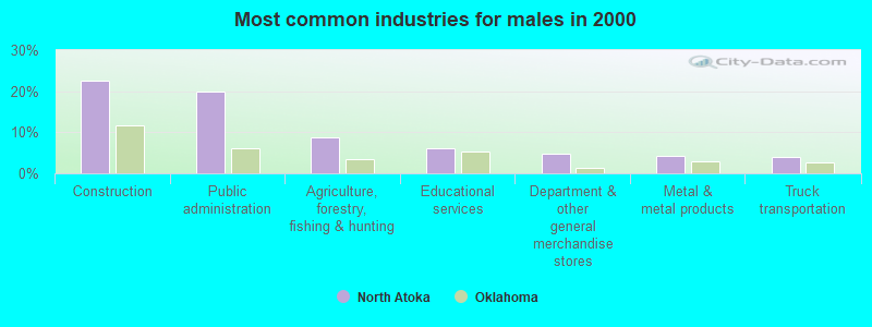
- Construction (22.6%)
- Public administration (19.8%)
- Agriculture, forestry, fishing & hunting (8.8%)
- Educational services (6.1%)
- Department & other general merchandise stores (4.9%)
- Metal & metal products (4.3%)
- Truck transportation (4.0%)
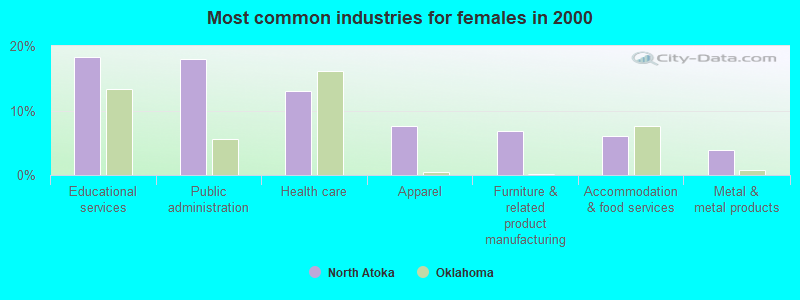
- Educational services (18.3%)
- Public administration (17.9%)
- Health care (13.0%)
- Apparel (7.6%)
- Furniture & related product manufacturing (6.9%)
- Accommodation & food services (6.1%)
- Metal & metal products (3.8%)
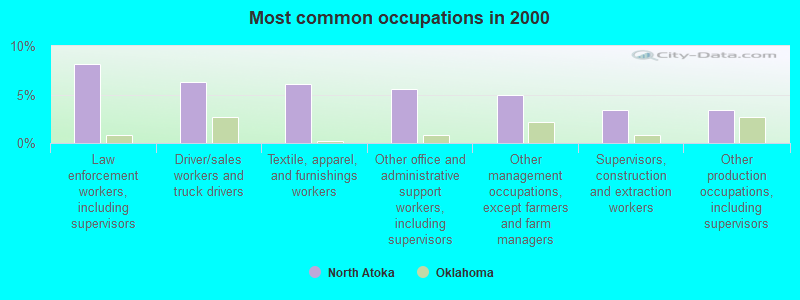
- Law enforcement workers, including supervisors (8.1%)
- Driver/sales workers and truck drivers (6.3%)
- Textile, apparel, and furnishings workers (6.1%)
- Other office and administrative support workers, including supervisors (5.6%)
- Other management occupations, except farmers and farm managers (4.9%)
- Supervisors, construction and extraction workers (3.4%)
- Other production occupations, including supervisors (3.4%)
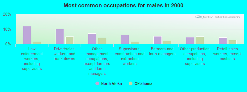
- Law enforcement workers, including supervisors (11.9%)
- Driver/sales workers and truck drivers (10.1%)
- Other management occupations, except farmers and farm managers (7.0%)
- Supervisors, construction and extraction workers (6.1%)
- Farmers and farm managers (5.2%)
- Other production occupations, including supervisors (4.6%)
- Retail sales workers, except cashiers (4.3%)

- Textile, apparel, and furnishings workers (13.0%)
- Other office and administrative support workers, including supervisors (8.8%)
- Secretaries and administrative assistants (5.7%)
- Waiters and waitresses (5.0%)
- Preschool, kindergarten, elementary, and middle school teachers (4.6%)
- Cashiers (3.8%)
- Health technologists and technicians (3.8%)
Average climate in North Atoka, Oklahoma
Based on data reported by over 4,000 weather stations


(lower is better)
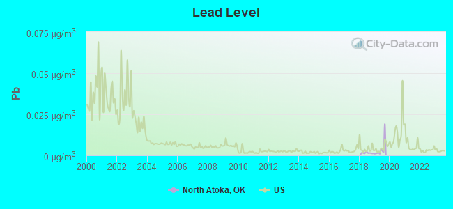
Lead (Pb) [µg/m3] level in 2019 was 0.00368. This is significantly better than average. Closest monitor was 24.2 miles away from the city center.
| City: | 0.00368 |
| U.S.: | 0.00931 |
Tornado activity:
North Atoka-area historical tornado activity is slightly below Oklahoma state average. It is 122% greater than the overall U.S. average.
On 5/11/1992, a category F4 (max. wind speeds 207-260 mph) tornado 14.8 miles away from the North Atoka place center injured 3 people and caused between $50,000 and $500,000 in damages.
On 4/2/1982, a category F5 (max. wind speeds 261-318 mph) tornado 35.2 miles away from the place center injured 29 people and caused between $500,000 and $5,000,000 in damages.
Earthquake activity:
North Atoka-area historical earthquake activity is significantly above Oklahoma state average. It is 658% greater than the overall U.S. average.On 11/6/2011 at 03:53:10, a magnitude 5.7 (5.7 MW, Depth: 3.2 mi, Class: Moderate, Intensity: VI - VII) earthquake occurred 83.2 miles away from the city center
On 9/3/2016 at 12:02:44, a magnitude 5.8 (5.8 MW, Depth: 3.5 mi) earthquake occurred 142.0 miles away from the city center
On 11/7/2016 at 01:44:24, a magnitude 5.0 (5.0 MW, Depth: 2.8 mi) earthquake occurred 111.8 miles away from North Atoka center
On 11/8/2011 at 02:46:57, a magnitude 4.8 (4.8 MW, Depth: 3.1 mi, Class: Light, Intensity: IV - V) earthquake occurred 83.9 miles away from the city center
On 11/5/2011 at 07:12:45, a magnitude 4.8 (4.8 MW, Depth: 1.9 mi) earthquake occurred 84.2 miles away from North Atoka center
On 9/6/1997 at 23:38:00, a magnitude 4.5 (4.5 LG, 4.2 LG, Depth: 3.1 mi) earthquake occurred 29.4 miles away from the city center
Magnitude types: regional Lg-wave magnitude (LG), moment magnitude (MW)
Natural disasters:
The number of natural disasters in Atoka County (23) is greater than the US average (15).Major Disasters (Presidential) Declared: 15
Emergencies Declared: 6
Causes of natural disasters: Storms: 14, Floods: 12, Tornadoes: 11, Winter Storms: 6, Winds: 3, Heavy Rain: 1, Hurricane: 1, Snow: 1, Other: 1 (Note: some incidents may be assigned to more than one category).
Hospitals and medical centers near North Atoka:
- PLANTATION MANOR INC (Nursing Home, about 15 miles away; ATOKA, OK)
- HOMETOWN HOSPICE (Hospital, about 15 miles away; ATOKA, OK)
- ATOKA COUNTY MEDICAL CENTER Critical Access Hospitals (about 15 miles away; ATOKA, OK)
- ATOKA CARE CENTER (Nursing Home, about 16 miles away; ATOKA, OK)
- COLONIAL LIVING CENTER (Nursing Home, about 16 miles away; ATOKA, OK)
Colleges/universities with over 2000 students nearest to North Atoka:
- East Central University (about 45 miles; Ada, OK; Full-time enrollment: 4,030)
- Southeastern Oklahoma State University (about 45 miles; Durant, OK; FT enrollment: 3,365)
- Paris Junior College (about 66 miles; Paris, TX; FT enrollment: 3,875)
- Grayson College (about 70 miles; Denison, TX; FT enrollment: 2,496)
- Oklahoma State University Institute of Technology (about 76 miles; Okmulgee, OK; FT enrollment: 3,243)
- Carl Albert State College (about 82 miles; Poteau, OK; FT enrollment: 2,041)
- Texas A & M University-Commerce (about 90 miles; Commerce, TX; FT enrollment: 8,890)
Points of interest:
Notable locations in North Atoka: Gap (A), Boggy Bend Ford (B), Wardville Rural Volunteer Fire Department (C), Daisy Volunteer Fire Department (D), Stringtown Fire Department (E), Mack Alford Correctional Center (F). Display/hide their locations on the map
Churches in North Atoka include: Bethany Church (A), McGee Church (B), Mount Olive Church (C). Display/hide their locations on the map
Cemeteries: Wards Cemetery (1), Baker Cemetery (2), Billy Cemetery (3), Kelly Cemetery (4), Boggy Bend Cemetery (5), Bethel Cemetery (6), Wesley Cemetery (7). Display/hide their locations on the map
Lakes and reservoirs: Texas Hole (A), Troly Lake (B), Oknoname 005001 Reservoir (C), Country Club Lake (D), Bluestem Lake (E), Atoka County Lake (F), Atoka Reservoir (G), Sub-Penitentiary Lake (H). Display/hide their locations on the map
Streams, rivers, and creeks: Buck Creek (A), Breadtown Creek (B), Bog Spring Branch (C), Blue Creek (D), Hiawana Creek (E), Birch Creek (F), Tommy Bond Branch (G), Beck Creek (H), Bear Creek (I). Display/hide their locations on the map
Parks in North Atoka include: Wildlife Management Area (1), Natural Scenic Recreation Area (2), Stringtown Public Hunting Area (3), Atoka State Game Refuge (4). Display/hide their locations on the map
| This place: | 2.4 people |
| Oklahoma: | 2.5 people |
| This place: | 72.0% |
| Whole state: | 66.8% |
| This place: | 4.5% |
| Whole state: | 5.9% |
Likely homosexual households (counted as self-reported same-sex unmarried-partner households)
- Lesbian couples: 0.2% of all households
- Gay men: 0.2% of all households
| This place: | 19.4% |
| Whole state: | 14.7% |
| This place: | 5.0% |
| Whole state: | 6.1% |
For population 15 years and over in North Atoka:
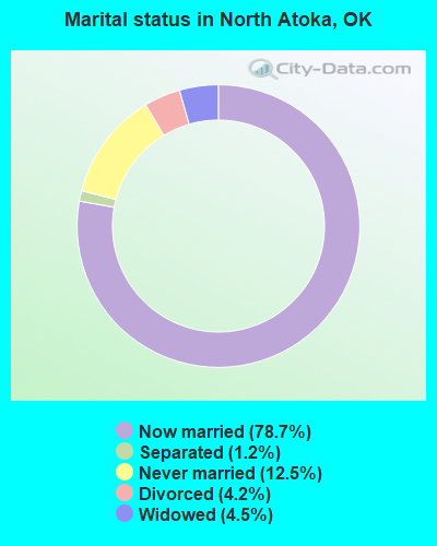
- Never married: 12.5%
- Now married: 78.7%
- Separated: 1.2%
- Widowed: 4.5%
- Divorced: 4.2%
For population 25 years and over in North Atoka:
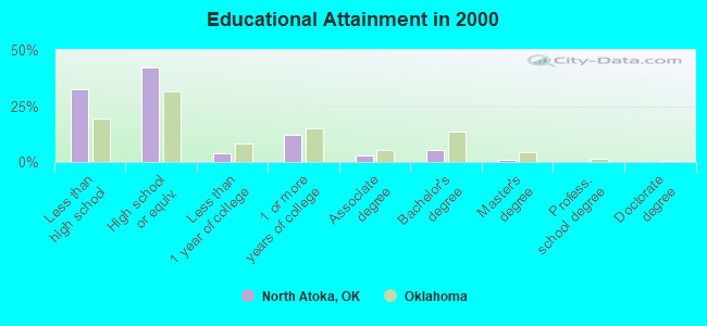
- High school or higher: 67.7%
- Bachelor's degree or higher: 6.4%
- Graduate or professional degree: 1.3%
- Unemployed: 5.6%
- Mean travel time to work (commute): 31.6 minutes
| Here: | 10.1 |
| Oklahoma average: | 11.7 |
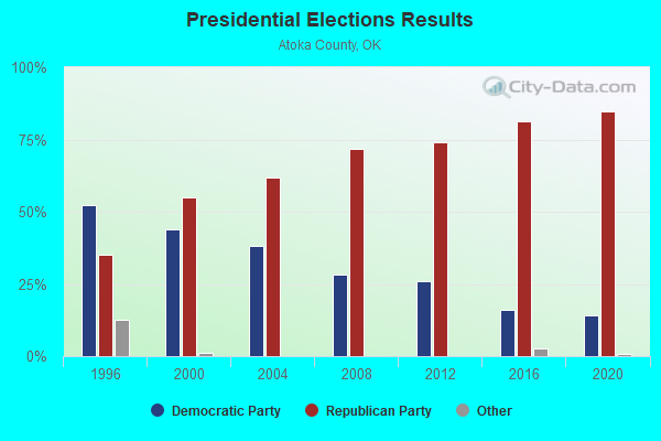
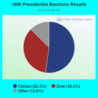
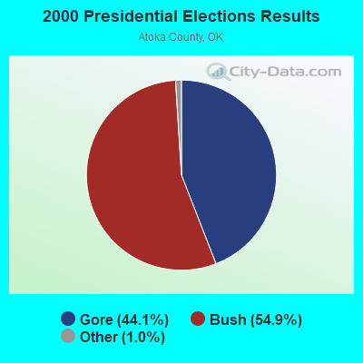
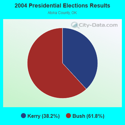
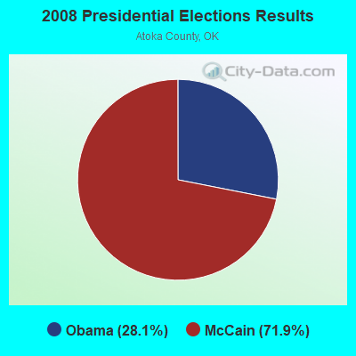
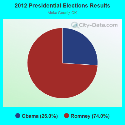
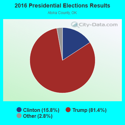
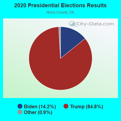
Graphs represent county-level data. Detailed 2008 Election Results
Religion statistics for North Atoka, OK (based on Atoka County data)
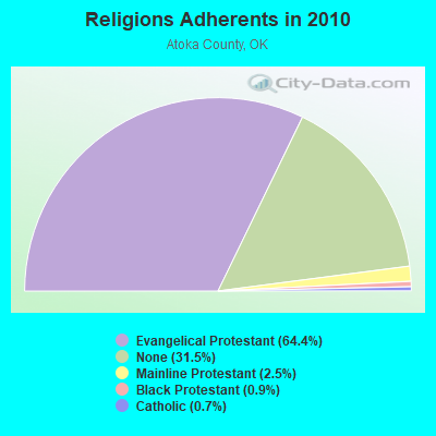
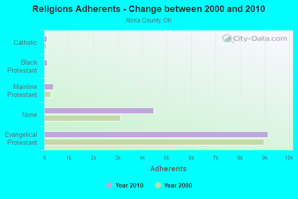
| Religion | Adherents | Congregations |
|---|---|---|
| Evangelical Protestant | 9,137 | 47 |
| Mainline Protestant | 358 | 4 |
| Black Protestant | 122 | 1 |
| Catholic | 100 | 1 |
| Other | 1 | 1 |
| None | 4,464 | - |
Food Environment Statistics:
| This county: | 4.83 / 10,000 pop. |
| Oklahoma: | 1.97 / 10,000 pop. |
| This county: | 0.69 / 10,000 pop. |
| Oklahoma: | 0.76 / 10,000 pop. |
| Atoka County: | 5.53 / 10,000 pop. |
| Oklahoma: | 4.35 / 10,000 pop. |
| This county: | 10.36 / 10,000 pop. |
| State: | 6.89 / 10,000 pop. |
| Atoka County: | 11.3% |
| State: | 10.3% |
| This county: | 31.1% |
| Oklahoma: | 29.2% |
Strongest AM radio stations in North Atoka:
- KEOR (1110 AM; daytime; 5 kW; ATOKA, OK; Owner: DALLAS AM RADIO PARTNERS, L.P.)
- KRMG (740 AM; 50 kW; TULSA, OK; Owner: CXR HOLDINGS, INC.)
- KFAQ (1170 AM; 50 kW; TULSA, OK; Owner: JOURNAL BROADCAST CORPORATION)
- KRLD (1080 AM; 50 kW; DALLAS, TX; Owner: TEXAS INFINITY BROADCASTING L.P.)
- KFXR (1190 AM; 50 kW; DALLAS, TX; Owner: CLEAR CHANNEL BROADCASTING LICENSES, INC.)
- KOMA (1520 AM; 50 kW; OKLAHOMA CITY, OK; Owner: RENDA BROADCASTING CORP. OF NEVADA)
- WBAP (820 AM; 50 kW; FORT WORTH, TX; Owner: WBAP-KSCS OPERATING, LTD.)
- KYNG (950 AM; 10 kW; DENISON-SHERMAN, TX; Owner: KRBE LICO, INC.)
- KEEL (710 AM; 50 kW; SHREVEPORT, LA; Owner: CITICASTERS LICENSES, L.P.)
- KESS (1270 AM; 50 kW; FORT WORTH, TX; Owner: KESS-AM LICENSE CORP.)
- KZMP (1540 AM; 50 kW; UNIVERSITY PARK, TX; Owner: ENTRAVISION HOLDINGS, LLC)
- KAHZ (1360 AM; 50 kW; HURST, TX)
- KSKY (660 AM; 20 kW; BALCH SPRINGS, TX; Owner: BISON MEDIA, INC.)
Strongest FM radio stations in North Atoka:
- KKFC (105.5 FM; COALGATE, OK; Owner: WOODSTONE BROADCASTING, INC.)
- KHKC-FM (102.1 FM; ATOKA, OK; Owner: KEYSTONE BROADCASTING CORPORATION)
- KQCV-FM (95.1 FM; SHAWNEE, OK; Owner: COMMUNITY BROADCASTING, INC)
- KAZC (88.3 FM; TISHOMINGO, OK; Owner: SOUTH CENTRAL OKLAHOMA CHRISTIAN BROADCASTING, INC.)
- KMCO (101.3 FM; MCALESTER, OK; Owner: LITTLE DIXIE RADIO, INC.)
- KESC (103.7 FM; WILBURTON, OK; Owner: LITTLE DIXIE RADIO, INC)
- KTMC-FM (105.1 FM; MCALESTER, OK; Owner: BOTTOM LINE BROADCASTING, INC.)
TV broadcast stations around North Atoka:
- KTEN (Channel 10; ADA, OK; Owner: CHANNEL 49 ACQUISITION CORPORATION)
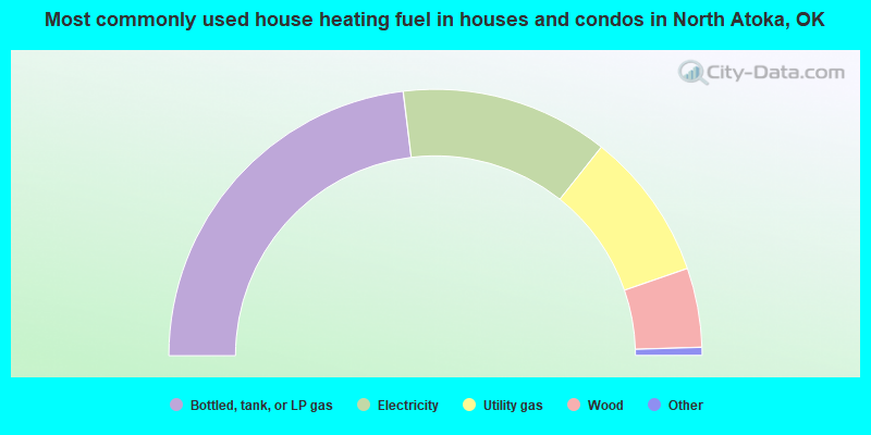
- 46.1%Bottled, tank, or LP gas
- 25.2%Electricity
- 18.0%Utility gas
- 9.6%Wood
- 0.6%Other fuel
- 0.4%No fuel used
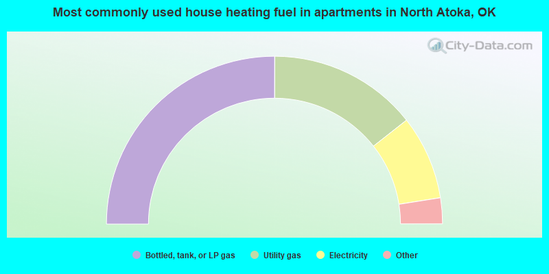
- 50.0%Bottled, tank, or LP gas
- 28.7%Utility gas
- 16.2%Electricity
- 2.5%Wood
- 2.5%Other fuel
North Atoka compared to Oklahoma state average:
- Median house value below state average.
- Unemployed percentage below state average.
- Black race population percentage above state average.
- Hispanic race population percentage significantly below state average.
- Foreign-born population percentage significantly below state average.
- Renting percentage below state average.
- Length of stay since moving in significantly above state average.
- Number of rooms per house significantly below state average.
- House age significantly below state average.
- Institutionalized population percentage significantly above state average.
- Percentage of population with a bachelor's degree or higher significantly below state average.
North Atoka on our top lists:
- #54 on the list of "Top 101 cities with the largest percentage of people in state prisons (population 1,000+)"
- #80 on the list of "Top 101 counties with the highest surface withdrawal of fresh water for public supply"