East Coal, Oklahoma
Submit your own pictures of this place and show them to the world
- OSM Map
- General Map
- Google Map
- MSN Map

| Males: 1,849 | |
| Females: 1,947 |
| Median resident age: | 39.2 years |
| Oklahoma median age: | 35.5 years |
Zip code: 74538
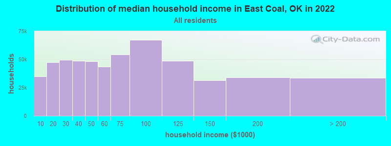
| East Coal: | $44,487 |
| OK: | $59,673 |
Estimated per capita income in 2022: $25,002 (it was $11,403 in 2000)
East Coal CCD income, earnings, and wages data
Estimated median house or condo value in 2022: $97,751 (it was $38,300 in 2000)
| East Coal: | $97,751 |
| OK: | $191,700 |
Detailed information about poverty and poor residents in East Coal, OK


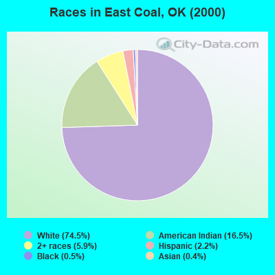
- 3,00574.5%White alone
- 66616.5%American Indian alone
- 2365.9%Two or more races
- 892.2%Hispanic
- 200.5%Black alone
- 150.4%Asian alone
Races in East Coal detailed stats: ancestries, foreign born residents, place of birth
 Recent articles from our blog. Our writers, many of them Ph.D. graduates or candidates, create easy-to-read articles on a wide variety of topics.
Current Local Time: CST time zone
Land area: 257.4 square miles.
Population density: 15 people per square mile (very low).

| East Coal CCD: | 0.6% ($224) |
| Oklahoma: | 0.8% ($523) |
Nearest city with pop. 50,000+: East Grayson, TX (65.6 miles  , pop. 81,381).
Nearest city with pop. 200,000+: Oklahoma City, OK (99.4 miles , pop. 506,132).
Nearest city with pop. 1,000,000+: Dallas, TX (124.8 miles , pop. 1,188,580).
Nearest cities:
), ), ), )Latitude: 34.54 N, Longitude: 96.21 W
Area code commonly used in this area: 580

| Here: | 4.5% |
| Oklahoma: | 3.2% |
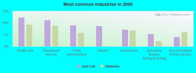
- Health care (12.4%)
- Educational services (11.3%)
- Public administration (9.2%)
- Apparel (8.8%)
- Construction (7.3%)
- Agriculture, forestry, fishing & hunting (5.4%)
- Accommodation & food services (4.1%)
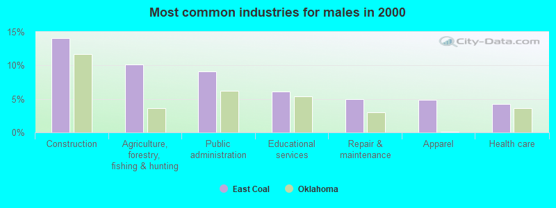
- Construction (14.1%)
- Agriculture, forestry, fishing & hunting (10.1%)
- Public administration (9.1%)
- Educational services (6.1%)
- Repair & maintenance (5.0%)
- Apparel (4.9%)
- Health care (4.2%)
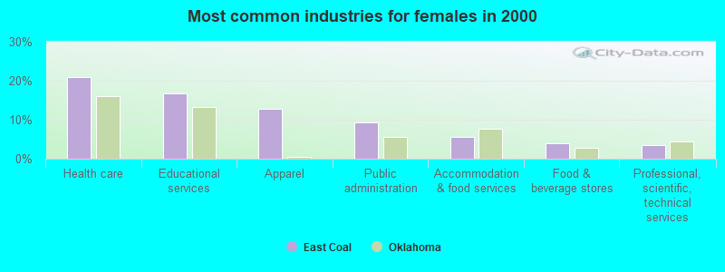
- Health care (20.9%)
- Educational services (16.7%)
- Apparel (12.9%)
- Public administration (9.2%)
- Accommodation & food services (5.6%)
- Food & beverage stores (3.9%)
- Professional, scientific, technical services (3.4%)
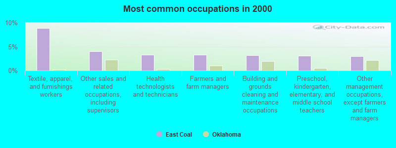
- Textile, apparel, and furnishings workers (8.9%)
- Other sales and related occupations, including supervisors (4.0%)
- Health technologists and technicians (3.3%)
- Farmers and farm managers (3.3%)
- Building and grounds cleaning and maintenance occupations (3.2%)
- Preschool, kindergarten, elementary, and middle school teachers (3.1%)
- Other management occupations, except farmers and farm managers (3.0%)
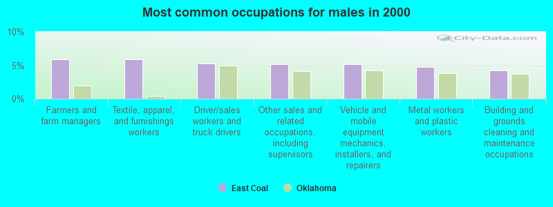
- Farmers and farm managers (5.9%)
- Textile, apparel, and furnishings workers (5.9%)
- Driver/sales workers and truck drivers (5.3%)
- Other sales and related occupations, including supervisors (5.1%)
- Vehicle and mobile equipment mechanics, installers, and repairers (5.1%)
- Metal workers and plastic workers (4.7%)
- Building and grounds cleaning and maintenance occupations (4.2%)
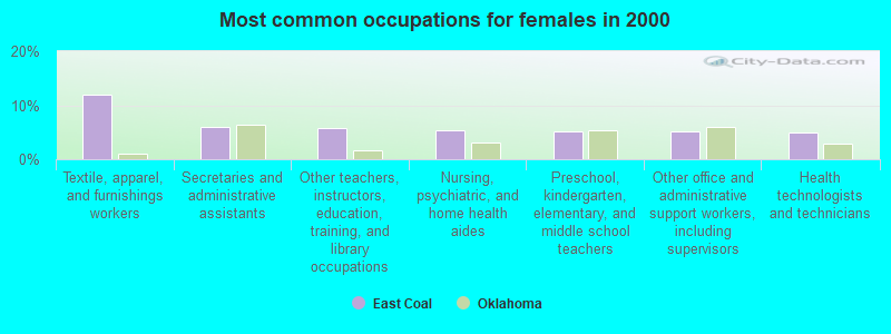
- Textile, apparel, and furnishings workers (11.9%)
- Secretaries and administrative assistants (6.0%)
- Other teachers, instructors, education, training, and library occupations (5.7%)
- Nursing, psychiatric, and home health aides (5.4%)
- Preschool, kindergarten, elementary, and middle school teachers (5.2%)
- Other office and administrative support workers, including supervisors (5.2%)
- Health technologists and technicians (5.0%)
Average climate in East Coal, Oklahoma
Based on data reported by over 4,000 weather stations


Tornado activity:
East Coal-area historical tornado activity is near Oklahoma state average. It is 141% greater than the overall U.S. average.
On 5/9/1959, a category F4 (max. wind speeds 207-260 mph) tornado 20.0 miles away from the East Coal place center killed 7 people and injured 12 people and caused between $50,000 and $500,000 in damages.
On 4/27/1966, a category F4 tornado 20.6 miles away from the place center injured 2 people and caused between $50,000 and $500,000 in damages.
Earthquake activity:
East Coal-area historical earthquake activity is significantly above Oklahoma state average. It is 672% greater than the overall U.S. average.On 11/6/2011 at 03:53:10, a magnitude 5.7 (5.7 MW, Depth: 3.2 mi, Class: Moderate, Intensity: VI - VII) earthquake occurred 75.5 miles away from East Coal center
On 9/3/2016 at 12:02:44, a magnitude 5.8 (5.8 MW, Depth: 3.5 mi) earthquake occurred 136.6 miles away from East Coal center
On 11/7/2016 at 01:44:24, a magnitude 5.0 (5.0 MW, Depth: 2.8 mi) earthquake occurred 105.8 miles away from East Coal center
On 11/8/2011 at 02:46:57, a magnitude 4.8 (4.8 MW, Depth: 3.1 mi, Class: Light, Intensity: IV - V) earthquake occurred 76.0 miles away from East Coal center
On 11/5/2011 at 07:12:45, a magnitude 4.8 (4.8 MW, Depth: 1.9 mi) earthquake occurred 76.6 miles away from the city center
On 9/6/1997 at 23:38:00, a magnitude 4.5 (4.5 LG, 4.2 LG, Depth: 3.1 mi) earthquake occurred 15.2 miles away from the city center
Magnitude types: regional Lg-wave magnitude (LG), moment magnitude (MW)
Natural disasters:
The number of natural disasters in Coal County (22) is greater than the US average (15).Major Disasters (Presidential) Declared: 13
Emergencies Declared: 6
Causes of natural disasters: Storms: 12, Floods: 11, Tornadoes: 10, Winter Storms: 7, Winds: 3, Heavy Rain: 1, Hurricane: 1, Snow: 1, Other: 1 (Note: some incidents may be assigned to more than one category).
Hospitals and medical centers near East Coal:
- TENDERCARE HOME HEALTH AGENCY (Home Health Center, about 1 miles away; COALGATE, OK)
- RUTH WILSON HURLEY MANOR (Nursing Home, about 1 miles away; COALGATE, OK)
- ATOKA COUNTY MEDICAL CENTER Critical Access Hospitals (about 11 miles away; ATOKA, OK)
- HOMETOWN HOSPICE (Hospital, about 12 miles away; ATOKA, OK)
- PLANTATION MANOR INC (Nursing Home, about 12 miles away; ATOKA, OK)
- ATOKA CARE CENTER (Nursing Home, about 12 miles away; ATOKA, OK)
- COLONIAL LIVING CENTER (Nursing Home, about 12 miles away; ATOKA, OK)
Colleges/universities with over 2000 students nearest to East Coal:
- East Central University (about 31 miles; Ada, OK; Full-time enrollment: 4,030)
- Southeastern Oklahoma State University (about 39 miles; Durant, OK; FT enrollment: 3,365)
- Grayson College (about 63 miles; Denison, TX; FT enrollment: 2,496)
- Paris Junior College (about 73 miles; Paris, TX; FT enrollment: 3,875)
- Oklahoma State University Institute of Technology (about 77 miles; Okmulgee, OK; FT enrollment: 3,243)
- North Central Texas College (about 84 miles; Gainesville, TX; FT enrollment: 6,550)
- University of Oklahoma-Norman Campus (about 84 miles; Norman, OK; FT enrollment: 22,496)
Points of interest:
Notable locations in East Coal: Oak Grove School (A), Midway (B), Lehigh Fire Department (C), Coalgate Fire Department and Emergency Medical Services (D), Cairo Volunteer Fire Department (E), Pine / Parker Volunteer Fire Department (F). Display/hide their locations on the map
Churches in East Coal include: Saint Peters Episcopal Church (A), Seventh Day Adventist Church (B), Methodist Church (C), Church of Christ (D), Lone Star Church (E), Legal Church (F). Display/hide their locations on the map
Cemeteries: Woodman Cemetery (1), Nixon Cemetery (2), Cairo Cemetery (3), Calvary Cemetery (4), King Cemetery (5), Lehigh Cemetery (6), McCarty Cemetery (7). Display/hide their locations on the map
Lakes and reservoirs: Old Grassy Lake (A), Cook and McEntire Reservoir (B), Caney Coon Creek Site 2 Reservoir (C), Gill Lake (D), Lower Clear Boggy Creek Site 22 Reservoir (E), Caney-Coon Creek Site 3 Reservoir (F), Leader Middle Clear Boggy Creek 42 Reservoir (G), Leader Middle Clear Boggy Creek 43 Reservoir (H). Display/hide their locations on the map
Creeks: Brier Creek (A), Black Creek (B), Sweetwater Creek (C), Sulphur Creek (D), Cedar Creek (E), Salt Creek (F), Caney Creek (G), Caney Boggy Creek (H), Rock Creek (I). Display/hide their locations on the map
| This place: | 2.5 people |
| Oklahoma: | 2.5 people |
| This place: | 66.4% |
| Whole state: | 66.8% |
| This place: | 4.8% |
| Whole state: | 5.9% |
Likely homosexual households (counted as self-reported same-sex unmarried-partner households)
- Lesbian couples: 0.5% of all households
- Gay men: 0.4% of all households
| This place: | 24.7% |
| Whole state: | 14.7% |
| This place: | 8.3% |
| Whole state: | 6.1% |
62 people in nursing homes in 2000
13 people in local jails and other confinement facilities (including police lockups) in 2000
For population 15 years and over in East Coal:
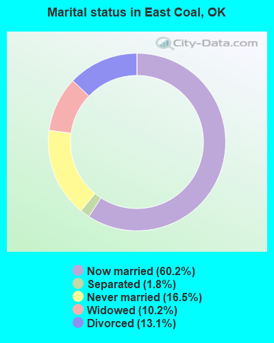
- Never married: 16.5%
- Now married: 60.2%
- Separated: 1.8%
- Widowed: 10.2%
- Divorced: 13.1%
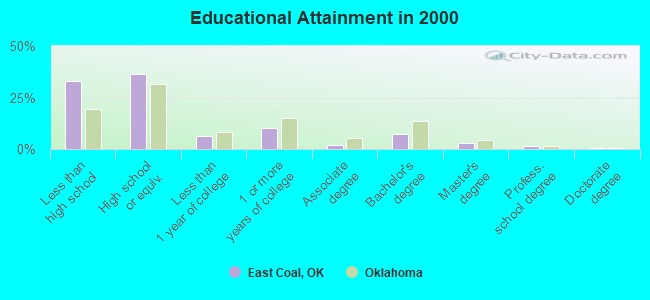
For population 25 years and over in East Coal:
- High school or higher: 66.9%
- Bachelor's degree or higher: 12.0%
- Graduate or professional degree: 4.7%
- Unemployed: 7.2%
- Mean travel time to work (commute): 19.6 minutes
| Here: | 13.8 |
| Oklahoma average: | 11.7 |
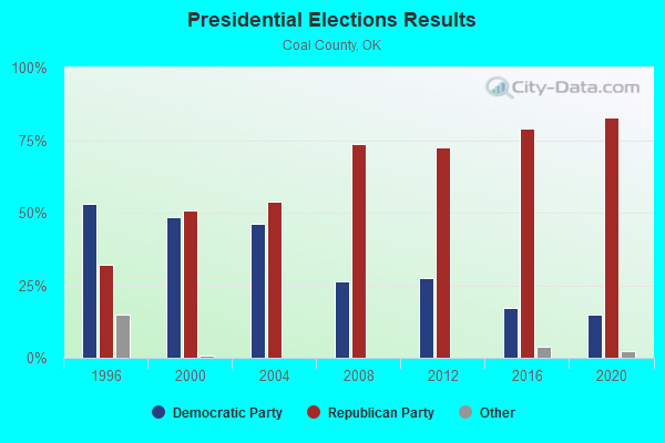
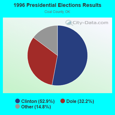
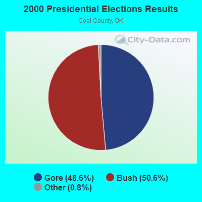
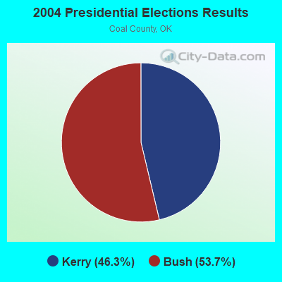
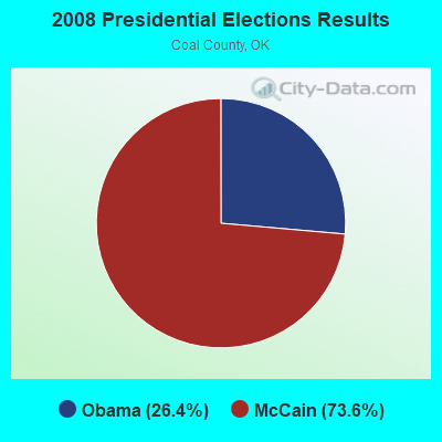
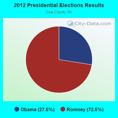
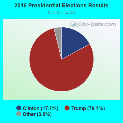
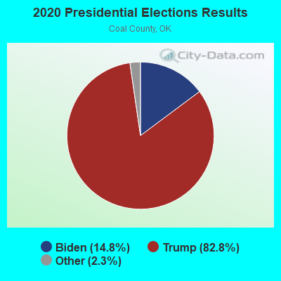
Graphs represent county-level data. Detailed 2008 Election Results
Religion statistics for East Coal, OK (based on Coal County data)
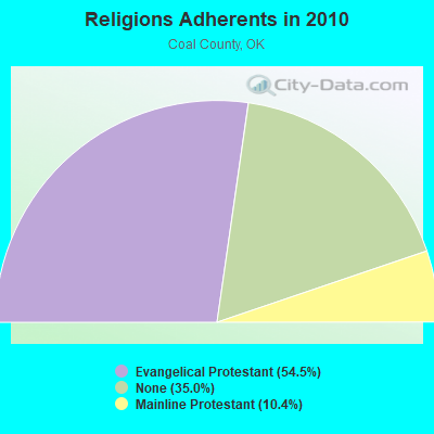
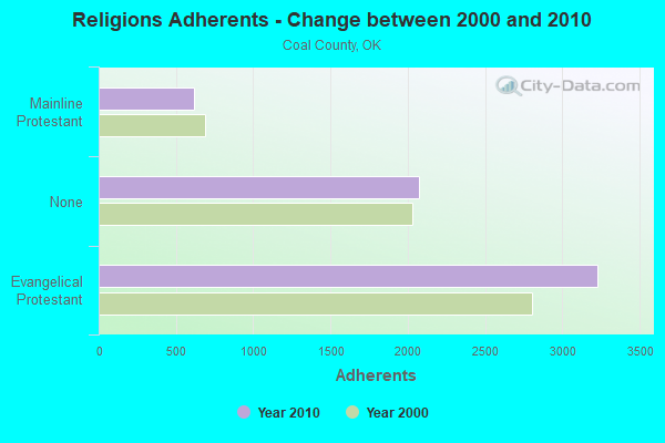
| Religion | Adherents | Congregations |
|---|---|---|
| Evangelical Protestant | 3,230 | 18 |
| Mainline Protestant | 619 | 4 |
| Other | 1 | - |
| Catholic | - | - |
| None | 2,075 | - |
Food Environment Statistics:
| Coal County: | 8.78 / 10,000 pop. |
| Oklahoma: | 1.97 / 10,000 pop. |
| Coal County: | 7.02 / 10,000 pop. |
| Oklahoma: | 4.35 / 10,000 pop. |
| Coal County: | 5.27 / 10,000 pop. |
| Oklahoma: | 6.89 / 10,000 pop. |
| Coal County: | 11.7% |
| Oklahoma: | 10.3% |
| Coal County: | 30.5% |
| State: | 29.2% |
Strongest AM radio stations in East Coal:
- KEOR (1110 AM; daytime; 5 kW; ATOKA, OK; Owner: DALLAS AM RADIO PARTNERS, L.P.)
- KRMG (740 AM; 50 kW; TULSA, OK; Owner: CXR HOLDINGS, INC.)
- KOMA (1520 AM; 50 kW; OKLAHOMA CITY, OK; Owner: RENDA BROADCASTING CORP. OF NEVADA)
- KRLD (1080 AM; 50 kW; DALLAS, TX; Owner: TEXAS INFINITY BROADCASTING L.P.)
- KFAQ (1170 AM; 50 kW; TULSA, OK; Owner: JOURNAL BROADCAST CORPORATION)
- KFXR (1190 AM; 50 kW; DALLAS, TX; Owner: CLEAR CHANNEL BROADCASTING LICENSES, INC.)
- WBAP (820 AM; 50 kW; FORT WORTH, TX; Owner: WBAP-KSCS OPERATING, LTD.)
- KYNG (950 AM; 10 kW; DENISON-SHERMAN, TX; Owner: KRBE LICO, INC.)
- KESS (1270 AM; 50 kW; FORT WORTH, TX; Owner: KESS-AM LICENSE CORP.)
- KZMP (1540 AM; 50 kW; UNIVERSITY PARK, TX; Owner: ENTRAVISION HOLDINGS, LLC)
- KEEL (710 AM; 50 kW; SHREVEPORT, LA; Owner: CITICASTERS LICENSES, L.P.)
- KAHZ (1360 AM; 50 kW; HURST, TX)
- KSKY (660 AM; 20 kW; BALCH SPRINGS, TX; Owner: BISON MEDIA, INC.)
Strongest FM radio stations in East Coal:
- KHKC-FM (102.1 FM; ATOKA, OK; Owner: KEYSTONE BROADCASTING CORPORATION)
- KKFC (105.5 FM; COALGATE, OK; Owner: WOODSTONE BROADCASTING, INC.)
- KAZC (88.3 FM; TISHOMINGO, OK; Owner: SOUTH CENTRAL OKLAHOMA CHRISTIAN BROADCASTING, INC.)
- KQCV-FM (95.1 FM; SHAWNEE, OK; Owner: COMMUNITY BROADCASTING, INC)
- K219CX (91.7 FM; ATOKA, OK; Owner: AMERICAN FAMILY ASSOCIATION)
TV broadcast stations around East Coal:
- KTEN (Channel 10; ADA, OK; Owner: CHANNEL 49 ACQUISITION CORPORATION)
- KXII (Channel 12; SHERMAN, TX; Owner: KXII LICENSEE CORP.)
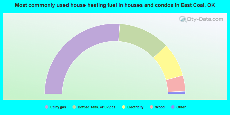
- 52.2%Utility gas
- 23.7%Bottled, tank, or LP gas
- 15.6%Electricity
- 7.3%Wood
- 0.8%Other fuel
- 0.3%Fuel oil, kerosene, etc.
- 0.2%No fuel used
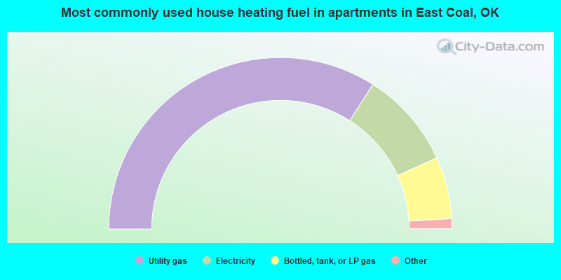
- 68.1%Utility gas
- 18.3%Electricity
- 11.7%Bottled, tank, or LP gas
- 1.3%Wood
- 0.4%No fuel used
- 0.2%Other fuel
East Coal compared to Oklahoma state average:
- Median house value below state average.
- Unemployed percentage below state average.
- Black race population percentage significantly below state average.
- Hispanic race population percentage significantly below state average.
- Foreign-born population percentage significantly below state average.
- Length of stay since moving in significantly above state average.
- Number of rooms per house significantly below state average.
- House age significantly below state average.
- Number of college students below state average.
- Percentage of population with a bachelor's degree or higher below state average.