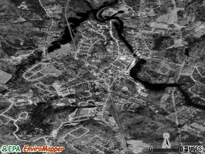
Newmarket, New Hampshire

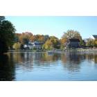
Newmarket: Reflection of the mill in Newmarket
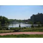
Newmarket: Riverview - Newmarket
Newmarket: Backside of the old mill on Main St
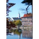
Newmarket: Church in Newmarket
- add
your
Submit your own pictures of this place and show them to the world
- OSM Map
- General Map
- Google Map
- MSN Map

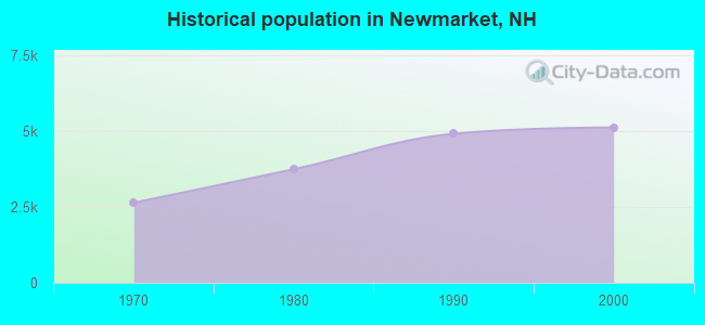
Population change since 2000: +3.4%
| Males: 2,692 | |
| Females: 2,605 |
| Median resident age: | 34.8 years |
| New Hampshire median age: | 43.3 years |
Zip codes: 03857.
| Newmarket: | $86,066 |
| NH: | $89,992 |
Estimated per capita income in 2022: $51,011 (it was $19,841 in 2000)
Newmarket CDP income, earnings, and wages data
Estimated median house or condo value in 2022: $388,922 (it was $116,200 in 2000)
| Newmarket: | $388,922 |
| NH: | $384,700 |
Mean prices in 2022: all housing units: $365,408; detached houses: $401,907; townhouses or other attached units: $263,469; in 2-unit structures: $326,036; in 3-to-4-unit structures: $595,281; in 5-or-more-unit structures: $309,356; mobile homes: $99,837
Median gross rent in 2022: $1,688.
(6.4% for White Non-Hispanic residents, 4.4% for two or more races residents)
Detailed information about poverty and poor residents in Newmarket, NH
Compare current foreclosures near Newmarket, NH:
| Photo | Address | Area | Beds / Baths | Price | Details |
|---|---|---|---|---|---|

|
#1
Langs Ln
Newmarket, NH 03857
|
2,466 sq. feet
|
2 baths 3 beds |
show details | |

|
#2
Piscassic St
Newmarket, NH 03857
|
1,608 sq. feet
|
2 baths 4 beds |
show details | |

|
#3
Mead Hill Rd
Newmarket, NH 03857
|
- sq. feet
|
- baths - beds |
show details | |

|
#4
Brentwood Rd
Exeter, NH 03833
|
2,756 sq. feet
|
2 baths 3 beds |
$419,900
|
show details |

|
#5
Williamine Dr
Newton, NH 03858
|
2,295 sq. feet
|
1 baths 3 beds |
show details | |

|
#6
Old Turnpike Rd
Nottingham, NH 03290
|
4,738 sq. feet
|
3 baths 3 beds |
show details | |

|
#7
Hobart St
Rochester, NH 03867
|
1,204 sq. feet
|
1 baths 4 beds |
show details | |

|
#8
Smoke St
Nottingham, NH 03290
|
2,681 sq. feet
|
2 baths 3 beds |
show details | |

|
#9
Woodlawn Cir
Portsmouth, NH 03801
|
1,306 sq. feet
|
2 baths 4 beds |
show details | |

|
#10
Tasker Hill Rd
Strafford, NH 03884
|
2,630 sq. feet
|
3 baths 3 beds |
show details |
| Photo | Address | Area | Beds / Baths | Price | Details |
|---|---|---|---|---|---|

|
#11
Senee Ct
Amesbury, MA 01913
|
1,190 sq. feet
|
1 baths 3 beds |
show details | |

|
#12
W Whitehall Rd
Amesbury, MA 01913
|
1,593 sq. feet
|
1 baths 3 beds |
show details | |

|
#13
Main Ave
East Kingston, NH 03827
|
1,982 sq. feet
|
1 baths 3 beds |
show details | |

|
#14
Whittier Meadows Dr
Amesbury, MA 01913
|
1,344 sq. feet
|
2 baths 2 beds |
show details | |

|
#15
Brown Ave # 52
Amesbury, MA 01913
|
741 sq. feet
|
1 baths 2 beds |
show details | |

|
#16
Cote Cir
Raymond, NH 03077
|
2,024 sq. feet
|
2 baths 3 beds |
show details | |

|
#17
Frost Hill Rd, C O Gregory Jackman
Eliot, ME 03903
|
3,472 sq. feet
|
3 baths 4 beds |
show details | |

|
#18
Lake St
Amesbury, MA 01913
|
2,650 sq. feet
|
2 baths 4 beds |
show details | |

|
#19
1st Nh Tpke
Northwood, NH 03261
|
3,778 sq. feet
|
2 baths 6 beds |
show details | |

|
#20
Twin Fawn Run
Chester, NH 03036
|
2,046 sq. feet
|
1 baths 3 beds |
show details |
| Photo | Address | Area | Beds / Baths | Price | Details |
|---|---|---|---|---|---|

|
#21
Elmwood St
Amesbury, MA 01913
|
1,848 sq. feet
|
1 baths 3 beds |
show details | |

|
#22
Del Logan Dr
Salisbury, MA 01952
|
1,986 sq. feet
|
1 baths 3 beds |
show details | |

|
#23
Blake Rd
Epping, NH 03042
|
3,113 sq. feet
|
2 baths 2 beds |
show details | |

|
#24
Maple St
Amesbury, MA 01913
|
2,186 sq. feet
|
2 baths 4 beds |
show details | |

|
#25
Aubin St # 1
Amesbury, MA 01913
|
1,230 sq. feet
|
2 baths 4 beds |
show details | |

|
#26
Roller Coaster Rd
Strafford, NH 03884
|
2,530 sq. feet
|
3 baths 6 beds |
show details | |

|
#27
Kimball Rd
Amesbury, MA 01913
|
1,792 sq. feet
|
1 baths 3 beds |
show details | |

|
#28
Meaderboro Rd
Rochester, NH 03867
|
- sq. feet
|
2 baths 3 beds |
show details | |

|
#29
Merrill Ave
Amesbury, MA 01913
|
1,467 sq. feet
|
1 baths 3 beds |
show details | |

|
#30
Main St Apt 4
Amesbury, MA 01913
|
645 sq. feet
|
1 baths 1 beds |
show details |
| Photo | Address | Area | Beds / Baths | Price | Details |
|---|---|---|---|---|---|

|
#31
Old Post Rd
York, ME 03909
|
864 sq. feet
|
1 baths 2 beds |
show details | |

|
#32
Elm St
Salisbury, MA 01952
|
1,800 sq. feet
|
2 baths 4 beds |
show details | |

|
#33
Northam Dr
Dover, NH 03820
|
1,999 sq. feet
|
2 baths 3 beds |
show details | |

|
#34
Mildred Ave
Raymond, NH 03077
|
756 sq. feet
|
2 baths 2 beds |
show details | |

|
#35
Chapel St
Dover, NH 03820
|
1,872 sq. feet
|
2 baths 4 beds |
show details | |

|
#36
Adams Park
Rye, NH 03870
|
1,008 sq. feet
|
2 baths 3 beds |
show details | |

|
#37
Cedar Point Rd
Durham, NH 03824
|
4,052 sq. feet
|
3 baths 3 beds |
show details | |

|
#38
Wentworth Ter
Dover, NH 03820
|
2,404 sq. feet
|
3 baths 6 beds |
show details | |

|
#39
Brentwood Rd
Exeter, NH 03833
|
3,683 sq. feet
|
3 baths 4 beds |
show details | |

|
#40
Harvard St
Exeter, NH 03833
|
1,509 sq. feet
|
1 baths 3 beds |
show details |
| Photo | Address | Area | Beds / Baths | Price | Details |
|---|---|---|---|---|---|

|
#41
Back River Rd
Dover, NH 03820
|
1,193 sq. feet
|
1 baths 3 beds |
show details | |

|
#42
Ernest Ave Apt 4
Exeter, NH 03833
|
555 sq. feet
|
1 baths 1 beds |
show details | |

|
#43
Plum St
Exeter, NH 03833
|
924 sq. feet
|
1 baths 3 beds |
show details | |

|
#44
Alder St
Exeter, NH 03833
|
952 sq. feet
|
2 baths 2 beds |
show details | |

|
#45
Middle Rd
Dover, NH 03820
|
1,120 sq. feet
|
1 baths 3 beds |
show details | |

|
#46
Dearborn Rd
Epping, NH 03042
|
1,768 sq. feet
|
2 baths 3 beds |
show details | |

|
#47
Pond St
Newton, NH 03858
|
- sq. feet
|
2 baths 3 beds |
show details | |

|
#48
Olde Farm Way
Berwick, ME 03901
|
2,376 sq. feet
|
3 baths - beds |
show details | |

|
#49
Pine Hill Rd
Berwick, ME 03901
|
2,882 sq. feet
|
2 baths - beds |
show details | |

|
Check over 1 million property listings on Foreclosure.com!
|
browse all offers | |||


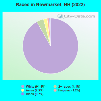
- 5,40091.4%White alone
- 2434.1%Two or more races
- 1312.2%Asian alone
- 681.2%Hispanic
- 430.7%Black alone
- 20.03%Other race alone
Races in Newmarket detailed stats: ancestries, foreign born residents, place of birth
According to our research of New Hampshire and other state lists, there were 6 registered sex offenders living in Newmarket, New Hampshire as of May 11, 2024.
The ratio of all residents to sex offenders in Newmarket is 938 to 1.
The ratio of registered sex offenders to all residents in this city is lower than the state average.
Type |
2009 |
2010 |
2011 |
2012 |
2015 |
2016 |
2017 |
2018 |
2019 |
2020 |
2021 |
2022 |
|---|---|---|---|---|---|---|---|---|---|---|---|---|
| Murders (per 100,000) | 0 (0.0) | 0 (0.0) | 0 (0.0) | 0 (0.0) | 0 (0.0) | 0 (0.0) | 0 (0.0) | 0 (0.0) | 0 (0.0) | 0 (0.0) | 0 (0.0) | 0 (0.0) |
| Rapes (per 100,000) | 4 (41.7) | 1 (11.2) | 3 (33.5) | 3 (33.4) | 2 (22.4) | 3 (33.7) | 5 (55.5) | 5 (54.6) | 2 (21.8) | 1 (10.9) | 5 (53.5) | 1 (10.6) |
| Robberies (per 100,000) | 0 (0.0) | 0 (0.0) | 0 (0.0) | 0 (0.0) | 0 (0.0) | 1 (11.2) | 0 (0.0) | 0 (0.0) | 0 (0.0) | 0 (0.0) | 1 (10.7) | 1 (10.6) |
| Assaults (per 100,000) | 6 (62.5) | 8 (89.5) | 2 (22.4) | 7 (77.9) | 7 (78.2) | 8 (89.8) | 6 (66.6) | 10 (109.2) | 6 (65.5) | 6 (65.3) | 2 (21.4) | 6 (63.7) |
| Burglaries (per 100,000) | 8 (83.3) | 9 (100.7) | 11 (122.9) | 15 (167.0) | 5 (55.9) | 4 (44.9) | 4 (44.4) | 10 (109.2) | 5 (54.6) | 1 (10.9) | 3 (32.1) | 2 (21.2) |
| Thefts (per 100,000) | 45 (468.7) | 23 (257.4) | 53 (592.3) | 46 (512.1) | 48 (536.5) | 24 (269.3) | 44 (488.7) | 36 (393.0) | 37 (403.9) | 30 (326.4) | 25 (267.4) | 43 (456.6) |
| Auto thefts (per 100,000) | 3 (31.2) | 1 (11.2) | 3 (33.5) | 4 (44.5) | 2 (22.4) | 5 (56.1) | 1 (11.1) | 1 (10.9) | 1 (10.9) | 1 (10.9) | 2 (21.4) | 2 (21.2) |
| Arson (per 100,000) | 0 (0.0) | 1 (11.2) | 1 (11.2) | 0 (0.0) | 0 (0.0) | 0 (0.0) | 1 (11.1) | 1 (10.9) | 1 (10.9) | 1 (10.9) | 0 (0.0) | 3 (31.9) |
| City-Data.com crime index | 72.9 | 45.1 | 66.3 | 78.0 | 60.7 | 66.7 | 81.3 | 89.7 | 51.4 | 36.4 | 64.9 | 45.9 |
The City-Data.com crime index weighs serious crimes and violent crimes more heavily. Higher means more crime, U.S. average is 246.1. It adjusts for the number of visitors and daily workers commuting into cities.
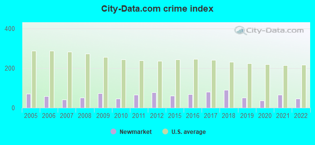
Crime rate in Newmarket detailed stats: murders, rapes, robberies, assaults, burglaries, thefts, arson
Full-time law enforcement employees in 2021, including police officers: 20 (13 officers - 12 male; 1 female).
| Officers per 1,000 residents here: | 1.39 |
| New Hampshire average: | 2.14 |
 Recent articles from our blog. Our writers, many of them Ph.D. graduates or candidates, create easy-to-read articles on a wide variety of topics.

 | Looking for rentals in the Newmarket/Dover/Portsmouth/Southern Maine area (2 replies) |
| Drinking water safety in Newmarket/Dover/Portsmouth (13 replies) |
| Epping/Newmarket Schools (4 replies) |
| NH Sale & Income tax offset with property taxes? (150 replies) |
| Best safe towns for commute to Portsmouth NH (34 replies) |
| Yet Another Guy Looking to Relocate to Southern NH (27 replies) |
Latest news from Newmarket, NH collected exclusively by city-data.com from local newspapers, TV, and radio stations
Ancestries: Italian (11.4%), American (11.2%), French Canadian (10.5%), Irish (8.5%), English (6.8%), European (5.1%).
Current Local Time: EST time zone
Incorporated in 1727
Land area: 1.94 square miles.
Population density: 2,734 people per square mile (average).
150 residents are foreign born (1.7% Asia, 0.4% North America).
| This place: | 2.5% |
| New Hampshire: | 6.0% |
Median real estate property taxes paid for housing units with mortgages in 2022: $6,771 (1.7%)
Median real estate property taxes paid for housing units with no mortgage in 2022: $6,154 (2.0%)
Nearest city with pop. 50,000+: Haverhill, MA  (22.0 miles , pop. 58,969).
Nearest city with pop. 200,000+: Boston, MA (52.8 miles , pop. 589,141).
Nearest city with pop. 1,000,000+: Bronx, NY (215.8 miles , pop. 1,332,650).
Nearest cities:
), ), ), ), ), Latitude: 43.08 N, Longitude: 70.94 W
Daytime population change due to commuting: -1,793 (-30.4%)
Workers who live and work in this place: 768 (19.5%)
Area code commonly used in this area: 603
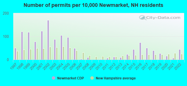
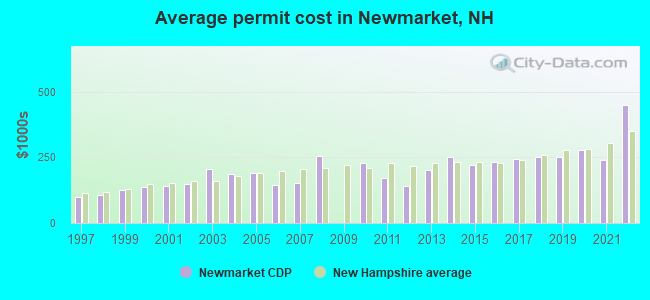
Single-family new house construction building permits:
- 2022: 23 buildings, average cost: $449,000
- 2021: 4 buildings, average cost: $241,000
- 2020: 8 buildings, average cost: $276,600
- 2019: 14 buildings, average cost: $250,700
- 2018: 20 buildings, average cost: $252,800
- 2017: 26 buildings, average cost: $244,700
- 2016: 38 buildings, average cost: $231,400
- 2015: 23 buildings, average cost: $220,700
- 2014: 12 buildings, average cost: $250,000
- 2013: 5 buildings, average cost: $203,300
- 2012: 6 buildings, average cost: $141,200
- 2011: 4 buildings, average cost: $170,000
- 2010: 1 building, cost: $230,000
- 2008: 5 buildings, average cost: $256,100
- 2007: 2 buildings, average cost: $151,300
- 2006: 25 buildings, average cost: $143,800
- 2005: 49 buildings, average cost: $189,400
- 2004: 54 buildings, average cost: $186,400
- 2003: 45 buildings, average cost: $204,700
- 2002: 87 buildings, average cost: $146,600
- 2001: 63 buildings, average cost: $138,600
- 2000: 40 buildings, average cost: $137,000
- 1999: 61 buildings, average cost: $125,500
- 1998: 62 buildings, average cost: $105,000
- 1997: 26 buildings, average cost: $97,500
| Here: | 2.6% |
| New Hampshire: | 2.5% |
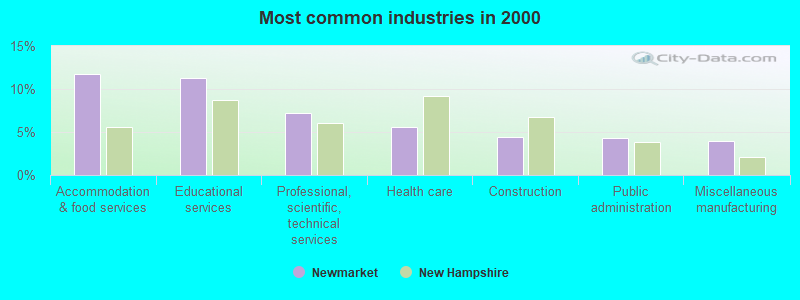
- Accommodation & food services (11.8%)
- Educational services (11.2%)
- Professional, scientific, technical services (7.2%)
- Health care (5.5%)
- Construction (4.5%)
- Public administration (4.3%)
- Miscellaneous manufacturing (3.9%)
- Accommodation & food services (11.2%)
- Construction (8.1%)
- Professional, scientific, technical services (7.2%)
- Educational services (6.8%)
- Computer & electronic products (5.1%)
- Miscellaneous manufacturing (5.0%)
- Administrative & support & waste management services (4.8%)
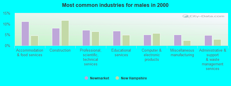
- Educational services (16.2%)
- Accommodation & food services (12.4%)
- Health care (10.7%)
- Professional, scientific, technical services (7.1%)
- Social assistance (5.2%)
- Finance & insurance (4.8%)
- Food & beverage stores (4.6%)
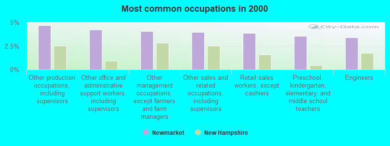
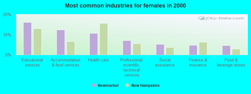
- Other production occupations, including supervisors (4.7%)
- Other office and administrative support workers, including supervisors (4.2%)
- Other management occupations, except farmers and farm managers (4.1%)
- Other sales and related occupations, including supervisors (4.0%)
- Retail sales workers, except cashiers (3.9%)
- Preschool, kindergarten, elementary, and middle school teachers (3.6%)
- Engineers (3.4%)
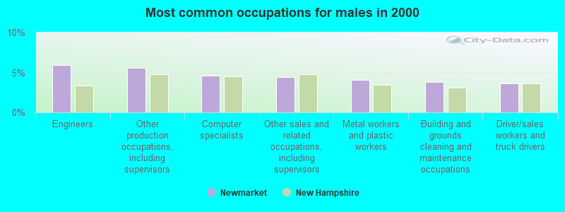
- Engineers (6.0%)
- Other production occupations, including supervisors (5.6%)
- Computer specialists (4.6%)
- Other sales and related occupations, including supervisors (4.4%)
- Metal workers and plastic workers (4.1%)
- Building and grounds cleaning and maintenance occupations (3.8%)
- Driver/sales workers and truck drivers (3.7%)
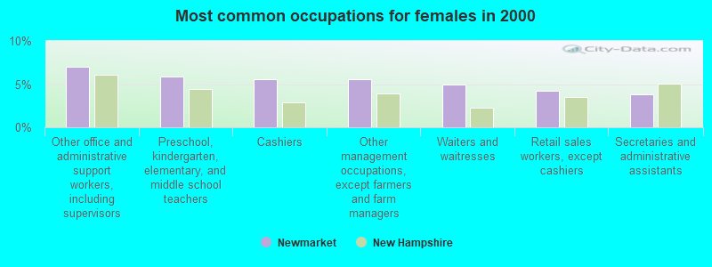
- Other office and administrative support workers, including supervisors (7.0%)
- Preschool, kindergarten, elementary, and middle school teachers (5.9%)
- Cashiers (5.6%)
- Other management occupations, except farmers and farm managers (5.5%)
- Waiters and waitresses (5.0%)
- Retail sales workers, except cashiers (4.3%)
- Secretaries and administrative assistants (3.8%)
Average climate in Newmarket, New Hampshire
Based on data reported by over 4,000 weather stations


|
|

(lower is better)
Air Quality Index (AQI) level in 2022 was 64.4. This is about average.
| City: | 64.4 |
| U.S.: | 72.6 |
Nitrogen Dioxide (NO2) [ppb] level in 2012 was 6.65. This is worse than average. Closest monitor was 7.5 miles away from the city center.
| City: | 6.65 |
| U.S.: | 5.11 |
Sulfur Dioxide (SO2) [ppb] level in 2022 was 1.48. This is about average. Closest monitor was 7.5 miles away from the city center.
| City: | 1.48 |
| U.S.: | 1.51 |
Ozone [ppb] level in 2022 was 29.6. This is about average. Closest monitor was 9.0 miles away from the city center.
| City: | 29.6 |
| U.S.: | 33.3 |
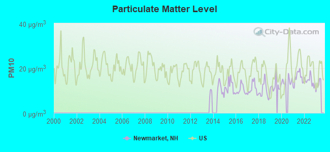
Particulate Matter (PM10) [µg/m3] level in 2022 was 14.4. This is better than average. Closest monitor was 8.7 miles away from the city center.
| City: | 14.4 |
| U.S.: | 19.2 |
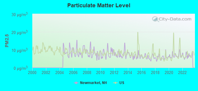
Particulate Matter (PM2.5) [µg/m3] level in 2022 was 6.48. This is better than average. Closest monitor was 9.0 miles away from the city center.
| City: | 6.48 |
| U.S.: | 8.11 |
Tornado activity:
Newmarket-area historical tornado activity is near New Hampshire state average. It is 53% smaller than the overall U.S. average.
On 6/9/1953, a category F3 (max. wind speeds 158-206 mph) tornado 7.6 miles away from the Newmarket place center injured 5 people and caused between $5000 and $50,000 in damages.
On 9/29/1974, a category F3 tornado 34.3 miles away from the place center injured one person and caused between $50,000 and $500,000 in damages.
Earthquake activity:
Newmarket-area historical earthquake activity is significantly above New Hampshire state average. It is 73% smaller than the overall U.S. average.On 10/16/2012 at 23:12:25, a magnitude 4.7 (4.7 ML, Depth: 10.0 mi, Class: Light, Intensity: IV - V) earthquake occurred 38.7 miles away from Newmarket center
On 4/20/2002 at 10:50:47, a magnitude 5.3 (5.3 ML, Depth: 3.0 mi, Class: Moderate, Intensity: VI - VII) earthquake occurred 169.7 miles away from Newmarket center
On 1/19/1982 at 00:14:42, a magnitude 4.7 (4.5 MB, 4.7 MD, 4.5 LG) earthquake occurred 44.3 miles away from the city center
On 10/7/1983 at 10:18:46, a magnitude 5.3 (5.1 MB, 5.3 LG, 5.1 ML) earthquake occurred 181.1 miles away from Newmarket center
On 4/20/2002 at 10:50:47, a magnitude 5.2 (5.2 MB, 4.2 MS, 5.2 MW, 5.0 MW) earthquake occurred 169.6 miles away from the city center
On 8/21/1996 at 07:54:14, a magnitude 3.8 (3.8 LG, 3.6 LG, Depth: 6.2 mi, Class: Light, Intensity: II - III) earthquake occurred 79.3 miles away from the city center
Magnitude types: regional Lg-wave magnitude (LG), body-wave magnitude (MB), duration magnitude (MD), local magnitude (ML), surface-wave magnitude (MS), moment magnitude (MW)
Natural disasters:
The number of natural disasters in Rockingham County (26) is a lot greater than the US average (15).Major Disasters (Presidential) Declared: 17
Emergencies Declared: 9
Causes of natural disasters: Storms: 12, Floods: 9, Winter Storms: 5, Hurricanes: 4, Snowstorms: 4, Snows: 2, Winds: 2, Blizzard: 1, Snowfall: 1, Tornado: 1 (Note: some incidents may be assigned to more than one category).

Hospitals and medical centers near Newmarket:
- ROCKINGHAM VNA AND HOSPICE (Home Health Center, about 7 miles away; EXETER, NH)
- EXETER HOSPITAL INC Acute Care Hospitals (about 7 miles away; EXETER, NH)
- EXETER HEALTHCARE (Nursing Home, about 7 miles away; EXETER, NH)
- EVENTIDE HOME INC (Nursing Home, about 7 miles away; EXETER, NH)
- FMC DIALYSIS SERVICES OF EXETER (Dialysis Facility, about 7 miles away; EXETER, NH)
- SEACOAST HOSPICE (Hospital, about 8 miles away; EXETER, NH)
- SAINT ANN REHABILITATION AND NURSING CENTER (Nursing Home, about 8 miles away; DOVER, NH)
Operable nuclear power plant near Newmarket:
- 15 miles: Seabrook in Seabrook, NH.
Colleges/universities with over 2000 students nearest to Newmarket:
- University of New Hampshire-Main Campus (about 4 miles; Durham, NH; Full-time enrollment: 15,243)
- Northern Essex Community College (about 21 miles; Haverhill, MA; FT enrollment: 4,737)
- Southern New Hampshire University (about 27 miles; Manchester, NH; FT enrollment: 16,552)
- Mount Washington College (about 28 miles; Manchester, NH; FT enrollment: 2,187)
- Saint Anselm College (about 30 miles; Manchester, NH; FT enrollment: 2,059)
- Merrimack College (about 30 miles; North Andover, MA; FT enrollment: 2,734)
- NHTI-Concord's Community College (about 32 miles; Concord, NH; FT enrollment: 2,865)
Public high school in Newmarket:
- NEWMARKET JR.-SR. HIGH SCHOOL (Students: 351, Location: 213 S. MAIN ST., Grades: 9-12)
Public elementary/middle schools in Newmarket:
- NEWMARKET ELEMENTARY SCHOOL (Students: 499, Location: 243 S. MAIN ST., Grades: PK-5)
- NEWMARKET JR.-SR. HIGH (ELEM) (Students: 257, Location: 213 S. MAIN ST., Grades: 6-8)
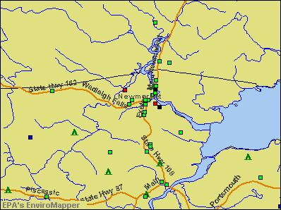
Points of interest:
Notable locations in Newmarket: Newmarket Fire and Rescue (A), Newmarket Public Library (B), Newmarket Town Hall (C). Display/hide their locations on the map
Churches in Newmarket include: Newmarket Community Church (A), New Market Congregational Church (B). Display/hide their locations on the map
Cemeteries: Riverside Cemetery (1), Cheswell Cemetery (2). Display/hide their locations on the map
Reservoir: Lamprey River Reservoir (A). Display/hide its location on the map
Streams, rivers, and creeks: Moonlight Brook (A). Display/hide its location on the map
Park in Newmarket: Newmarket Industrial and Commercial Historic District (1). Display/hide its location on the map
Tourist attraction: Julie& Brownie (Arcades & Amusements; 47 Exeter Street).
Birthplace of: Tom Gunning - Baseball player.
Drinking water stations with addresses in Newmarket and their reported violations in the past:
NEWMARKET WATER WORKS (Population served: 5,000, Groundwater):Past monitoring violations:
- 34 regular monitoring violations
| This place: | 2.2 people |
| New Hampshire: | 2.5 people |
| This place: | 49.1% |
| Whole state: | 66.3% |
| This place: | 13.5% |
| Whole state: | 8.3% |
Likely homosexual households (counted as self-reported same-sex unmarried-partner households)
- Lesbian couples: 0.6% of all households
- Gay men: 0.3% of all households
2 people in religious group quarters in 2000
Banks with branches in Newmarket (2011 data):
- TD Bank, National Association: Newmarket Branch at 72 Exeter Street, branch established on 1985/07/01. Info updated 2010/10/04: Bank assets: $188,912.6 mil, Deposits: $153,149.8 mil, headquarters in Wilmington, DE, positive income, 1314 total offices, Holding Company: Toronto-Dominion Bank, The
- Bank of America, National Association: Newmarket Branch at 140 Main Street, branch established on 1964/04/06. Info updated 2009/11/18: Bank assets: $1,451,969.3 mil, Deposits: $1,077,176.8 mil, headquarters in Charlotte, NC, positive income, 5782 total offices, Holding Company: Bank Of America Corporation
For population 15 years and over in Newmarket:
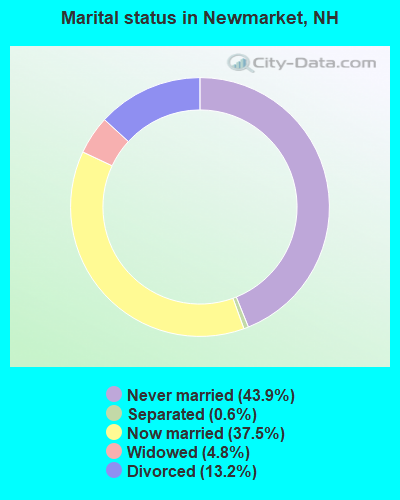
- Never married: 43.9%
- Now married: 37.5%
- Separated: 0.6%
- Widowed: 4.8%
- Divorced: 13.2%
For population 25 years and over in Newmarket:
- High school or higher: 99.2%
- Bachelor's degree or higher: 53.3%
- Graduate or professional degree: 19.7%
- Unemployed: 3.3%
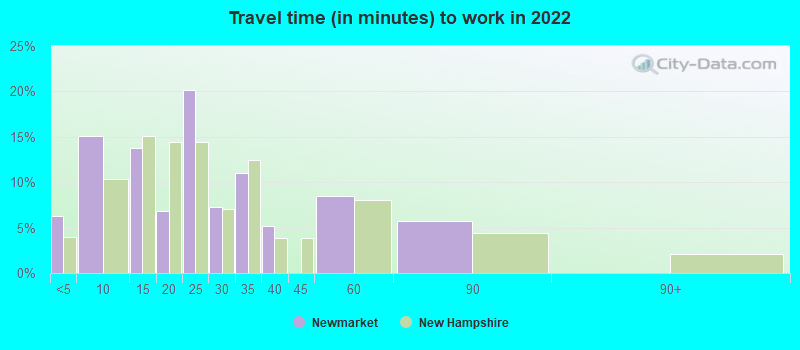
- Mean travel time to work (commute): 22.2 minutes

| Here: | 8.3 |
| New Hampshire average: | 10.3 |


Graphs represent county-level data. Detailed 2008 Election Results
Religion statistics for Newmarket, NH (based on Rockingham County data)


| Religion | Adherents | Congregations |
|---|---|---|
| Catholic | 84,697 | 24 |
| Mainline Protestant | 19,072 | 78 |
| Evangelical Protestant | 7,456 | 61 |
| Other | 3,490 | 20 |
| Orthodox | 200 | 1 |
| None | 180,308 | - |
Food Environment Statistics:
| Rockingham County: | 1.59 / 10,000 pop. |
| State: | 2.14 / 10,000 pop. |
| This county: | 0.17 / 10,000 pop. |
| New Hampshire: | 0.15 / 10,000 pop. |
| This county: | 1.86 / 10,000 pop. |
| New Hampshire: | 1.78 / 10,000 pop. |
| Rockingham County: | 3.31 / 10,000 pop. |
| New Hampshire: | 4.02 / 10,000 pop. |
| This county: | 9.56 / 10,000 pop. |
| New Hampshire: | 9.70 / 10,000 pop. |
| This county: | 7.6% |
| State: | 7.6% |
| Rockingham County: | 23.3% |
| New Hampshire: | 24.4% |
| This county: | 16.8% |
| New Hampshire: | 15.9% |
Health and Nutrition:
| Newmarket: | 60.6% |
| New Hampshire: | 51.2% |
| Here: | 67.9% |
| New Hampshire: | 49.1% |
| Newmarket: | 26.6 |
| New Hampshire: | 28.5 |
| Newmarket: | 16.5% |
| State: | 20.9% |
| This city: | 5.7% |
| New Hampshire: | 9.3% |
| This city: | 7.1 |
| New Hampshire: | 6.9 |
| Newmarket: | 26.8% |
| State: | 34.3% |
| Newmarket: | 70.6% |
| New Hampshire: | 58.1% |
| Newmarket: | 85.9% |
| New Hampshire: | 79.1% |
More about Health and Nutrition of Newmarket, NH Residents
7.69% of this county's 2021 resident taxpayers lived in other counties in 2020 ($114,534 average adjusted gross income)
| Here: | 7.69% |
| New Hampshire average: | 7.66% |
0.01% of residents moved from foreign countries ($203 average AGI)
Rockingham County: 0.01% New Hampshire average: 0.01%
Top counties from which taxpayers relocated into this county between 2020 and 2021:
| from Essex County, MA | |
| from Hillsborough County, NH | |
| from Middlesex County, MA |
6.82% of this county's 2020 resident taxpayers moved to other counties in 2021 ($88,778 average adjusted gross income)
| Here: | 6.82% |
| New Hampshire average: | 6.80% |
0.01% of residents moved to foreign countries ($126 average AGI)
Rockingham County: 0.01% New Hampshire average: 0.01%
Top counties to which taxpayers relocated from this county between 2020 and 2021:
| to Hillsborough County, NH | |
| to Strafford County, NH | |
| to Essex County, MA |
| Businesses in Newmarket, NH | ||||
| Name | Count | Name | Count | |
|---|---|---|---|---|
| Circle K | 1 | Rite Aid | 1 | |
| GNC | 1 | Subway | 1 | |
| McDonald's | 1 | UPS | 1 | |
Strongest AM radio stations in Newmarket:
- WGIP (1540 AM; 5 kW; EXETER, NH; Owner: CAPSTAR TX LIMITED PARTNERSHIP)
- WTSN (1270 AM; 5 kW; DOVER, NH; Owner: GARRISON CITY BROADCASTING, INC.)
- WGIN (930 AM; 10 kW; ROCHESTER, NH; Owner: CAPSTAR TX LIMITED PARTNERSHIP)
- WRKO (680 AM; 50 kW; BOSTON, MA; Owner: ENTERCOM BOSTON LICENSE, LLC)
- WEEI (850 AM; 50 kW; BOSTON, MA; Owner: ENTERCOM BOSTON LICENSE, LLC)
- WBZ (1030 AM; 50 kW; BOSTON, MA; Owner: INFINITY BROADCASTING OPERATIONS, INC.)
- WDER (1320 AM; 10 kW; DERRY, NH; Owner: BLOUNT COMMUNICATIONS, INC. OF NH)
- WWZN (1510 AM; 50 kW; BOSTON, MA; Owner: ROSE CITY RADIO CORPORATION)
- WMYF (1380 AM; 1 kW; PORTSMOUTH, NH; Owner: CAPSTAR TX LIMITED PARTNERSHIP)
- WKOX (1200 AM; 50 kW; FRAMINGHAM, MA; Owner: CAPSTAR TX LIMITED PARTNERSHIP)
- WBIX (1060 AM; 40 kW; NATICK, MA; Owner: LANGER BROADCASTING CORPORATION)
- WGIR (610 AM; 5 kW; MANCHESTER, NH; Owner: CAPSTAR TX LIMITED PARTNERSHIP)
- WCRN (830 AM; 50 kW; WORCESTER, MA; Owner: CARTER BROADCASTING CORPORATION)
Strongest FM radio stations in Newmarket:
- WERZ (107.1 FM; EXETER, NH; Owner: CAPSTAR TX LIMITED PARTNERSHIP)
- WUNH (91.3 FM; DURHAM, NH; Owner: UNIVERSITY OF NEW HAMPSHIRE)
- WHEB (100.3 FM; PORTSMOUTH, NH; Owner: CAPSTAR TX LIMITED PARTNERSHIP)
- WOKQ (97.5 FM; DOVER, NH; Owner: CITADEL BROADCASTING COMPANY)
- WUBB (95.3 FM; YORK CENTER, ME; Owner: CAPSTAR TX LIMITED PARTNERSHIP)
- WSHK (105.3 FM; KITTERY, ME; Owner: CITADEL BROADCASTING COMPANY)
- WBYY (98.7 FM; SOMERSWORTH, NH; Owner: GARRISON CITY BROADCASTING, INC.)
- WXRV (92.5 FM; HAVERHILL, MA; Owner: BEANPOT BROADCASTING CORP.)
- WSCY (106.9 FM; MOULTONBOROUGH, NH; Owner: NORTHEAST COMMUNICATIONS CORPORATION)
- WPKQ (103.7 FM; NORTH CONWAY, NH; Owner: CITADEL BROADCASTING COMPANY)
- WSAK (102.1 FM; HAMPTON, NH; Owner: CITADEL BROADCASTING COMPANY)
- WHOM (94.9 FM; MT. WASHINGTON, NH; Owner: CITADEL BROADCASTING COMPANY)
- WMEX (106.5 FM; FARMINGTON, NH; Owner: WIMMEX, LLC)
- WNEF (91.7 FM; NEWBURYPORT, MA; Owner: UNIVERSITY OF MASSACHUSETTS)
- WGIR-FM (101.1 FM; MANCHESTER, NH; Owner: CAPSTAR TX LIMITED PARTNERSHIP)
- WQSO (96.7 FM; ROCHESTER, NH; Owner: CAPSTAR TX LIMITED PARTNERSHIP)
- WMEA (90.1 FM; PORTLAND, ME; Owner: MAINE PUBLIC BROADCASTING CORPORATION)
- WQLL (96.5 FM; BEDFORD, NH; Owner: SAGA COMMUNICATIONS OF NEW ENGLAND, LLC)
- WLMW (90.7 FM; MANCHESTER, NH; Owner: KNOWLEDGE FOR LIFE)
- WPHX-FM (92.1 FM; SANFORD, ME; Owner: FNX BROADCASTING LLC)
TV broadcast stations around Newmarket:
- WHDN-LP (Channel 26; BOSTON, MA; Owner: GUENTER MARKSTEINER)
- WMEA-TV (Channel 26; BIDDEFORD, ME; Owner: MAINE PUBLIC BROADCASTING CORP.)
- WENH-TV (Channel 11; DURHAM, NH; Owner: UNIVERSITY OF NEW HAMPSHIRE)
- WFXZ-CA (Channel 24; BOSTON, MA; Owner: BOSTON BROADCASTING CORP.)
- WMTW-TV (Channel 8; POLAND SPRING, ME; Owner: WMTW BROADCAST GROUP, LLC)
- WPXG (Channel 21; CONCORD, NH; Owner: PAXSON BOSTON-68 LICENSE, INC.)
- National Bridge Inventory (NBI) Statistics
- 7Number of bridges
- 36ft / 11.1mTotal length
- $21,994,000Total costs
- 21,752Total average daily traffic
- 852Total average daily truck traffic
- 32,190Total future (year 2042) average daily traffic
FCC Registered Antenna Towers:
3- Edward G Roach, Dpw Garage, Route 152 (Lat: 43.082361 Lon: -70.975861), Type: 60.6, Overall height: 60.6 m, Registrant: Sba Properties, Inc., Eroach@sbasite.Com, , Boca -Raton, Phone: (800) 487-7483
- Edward G Roach, Dpw Garage, Route 152 (Lat: 43.082361 Lon: -70.975861), Type: 60.6, Overall height: 60.6 m, Registrant: Sba Properties, Inc., Eroach@sbasite.Com, , Boca -Raton, Phone: (800) 487-7483
- Edward G Roach, Dpw Garage, Route 152 (Lat: 43.082361 Lon: -70.975861), Type: 60.6, Structure height: 33015 m, Overall height: 60.6 m, Registrant: Sba Properties, LLC, Eroach@sbasite.Com, , Boca -Raton, Phone: (561) 995-7670
FCC Registered Broadcast Land Mobile Towers:
6- Newmarket Police Dept Main St (Lat: 43.411750 Lon: -70.936167), Call Sign: KVI697,
Assigned Frequencies: 155.475 MHz, 156.090 MHz, Grant Date: 04/27/2022, Expiration Date: 07/09/2032, Registrant: Nh Dept. Of Safety/Emergency Services And Communications, 33 Hazen Dr (Mailing), Concord, NH 03305, Phone: (603) 528-7541, Fax: (603) 271-6629, Email:
- Police Station (Lat: 43.411750 Lon: -70.936167), Call Sign: WPG47,
Assigned Frequencies: 155.460 MHz, Grant Date: 12/09/1997, Expiration Date: 02/11/2003, Cancellation Date: 05/18/2003, Registrant: County Of Rockingham, 101 North Rd, Brentwood, NH 03833, Phone: (603) 679-2225
- Bennett Well(Off Lee Hook Rd) (Lat: 43.083556 Lon: -70.976194), Type: Building, Structure height: 4.5 m, Overall height: 6 m, Call Sign: WPTZ572,
Assigned Frequencies: 462.050 MHz, Grant Date: 01/17/2002, Expiration Date: 01/17/2012, Cancellation Date: 11/05/2002, Certifier: George F Laney, Registrant: Electrical Installations Inc, Rte 25 At Harbor Sq, Center Harbor, NH 03226, Phone: (603) 253-4525, Fax: (603) 253-6284, Email:
- 5 Forbes Road (Lat: 43.075278 Lon: -70.940556), Call Sign: WQDT429, Licensee ID: L01068101,
Assigned Frequencies: 467.875 MHz, 467.762 MHz, 467.812 MHz, 467.850 MHz, 467.900 MHz, 467.925 MHz, Grant Date: 10/26/2005, Expiration Date: 10/26/2015, Cancellation Date: 12/26/2015, Certifier: Shari A Morse, Registrant: Russound Fmp Inc, 5 Forbes Road, Newmarket, NH 03857, Phone: (603) 659-5170, Fax: (603) 292-0406, Email:
- Blending Facility (Lat: 43.066472 Lon: -70.952583), Type: Building, Structure height: 6.1 m, Overall height: 7.6 m, Call Sign: WQPK339,
Assigned Frequencies: 218.375 MHz, Grant Date: 05/24/2022, Expiration Date: 06/12/2032, Certifier: Sean T Greig, Registrant: 2-Way Communications Service, Inc., 19 Durham Street, Portsmouth, NH 03801-2872, Phone: (603) 431-6288, Email:
- HIGH SCHOOL, 213 S Main St (Lat: 43.074556 Lon: -70.945194), Type: Bant, Structure height: 7 m, Overall height: 9.1 m, Call Sign: WRCK972,
Assigned Frequencies: 151.587 MHz, Grant Date: 10/29/2018, Expiration Date: 10/29/2028, Certifier: Jim Miner, Registrant: Cara Enterprises, Inc, Las Vegas, NV 89140-0124, Phone: (702) 838-9728, Fax: (702) 363-4607, Email:
FCC Registered Amateur Radio Licenses:
70 (See the full list of FCC Registered Amateur Radio Licenses in Newmarket)FAA Registered Aircraft:
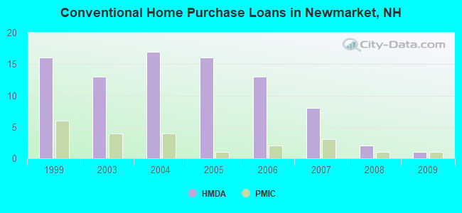
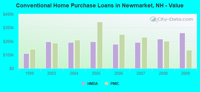
11 (See the full list of FAA Registered Aircraft in Newmarket)| Home Mortgage Disclosure Act Aggregated Statistics For Year 2009 (Based on 1 partial tract) | ||||||||||
| A) FHA, FSA/RHS & VA Home Purchase Loans | B) Conventional Home Purchase Loans | C) Refinancings | D) Home Improvement Loans | F) Non-occupant Loans on < 5 Family Dwellings (A B C & D) | ||||||
|---|---|---|---|---|---|---|---|---|---|---|
| Number | Average Value | Number | Average Value | Number | Average Value | Number | Average Value | Number | Average Value | |
| LOANS ORIGINATED | 2 | $188,235 | 1 | $261,520 | 15 | $200,623 | 1 | $107,840 | 1 | $194,360 |
| APPLICATIONS APPROVED, NOT ACCEPTED | 0 | $0 | 0 | $0 | 1 | $192,650 | 0 | $0 | 0 | $0 |
| APPLICATIONS DENIED | 0 | $0 | 0 | $0 | 5 | $215,246 | 0 | $0 | 0 | $0 |
| APPLICATIONS WITHDRAWN | 0 | $0 | 0 | $0 | 6 | $182,273 | 1 | $34,310 | 0 | $0 |
| FILES CLOSED FOR INCOMPLETENESS | 0 | $0 | 0 | $0 | 1 | $125,740 | 0 | $0 | 0 | $0 |
Detailed HMDA statistics for the following Tracts: 0675.02
| Private Mortgage Insurance Companies Aggregated Statistics For Year 2009 (Based on 1 partial tract) | ||
| A) Conventional Home Purchase Loans | ||
|---|---|---|
| Number | Average Value | |
| LOANS ORIGINATED | 1 | $134,810 |
| APPLICATIONS APPROVED, NOT ACCEPTED | 0 | $0 |
| APPLICATIONS DENIED | 0 | $0 |
| APPLICATIONS WITHDRAWN | 0 | $0 |
| FILES CLOSED FOR INCOMPLETENESS | 0 | $0 |
Detailed PMIC statistics for the following Tracts: 0675.02
2002 - 2018 National Fire Incident Reporting System (NFIRS) incidents
- Fire incident types reported to NFIRS in Newmarket, NH
- 21763.5%Structure Fires
- 9226.9%Outside Fires
- 247.0%Mobile Property/Vehicle Fires
- 92.6%Other
 Based on the data from the years 2002 - 2018 the average number of fires per year is 20. The highest number of fire incidents - 35 took place in 2013, and the least - 2 in 2002. The data has a growing trend.
 When looking into fire subcategories, the most incidents belonged to: Structure Fires (63.5%), and Outside Fires (26.9%).
- 58.3%Fuel oil, kerosene, etc.
- 22.2%Bottled, tank, or LP gas
- 13.3%Electricity
- 3.7%Wood
- 2.5%Utility gas
- 49.1%Electricity
- 18.8%Fuel oil, kerosene, etc.
- 16.6%Bottled, tank, or LP gas
- 12.1%Utility gas
- 1.7%No fuel used
- 1.0%Other fuel
- 0.7%Wood
Newmarket compared to New Hampshire state average:
- Unemployed percentage significantly below state average.
- Hispanic race population percentage significantly below state average.
- Median age significantly below state average.
- Foreign-born population percentage below state average.
- Renting percentage above state average.
- Length of stay since moving in significantly above state average.
- Percentage of population with a bachelor's degree or higher above state average.
Newmarket on our top lists:
- #9 on the list of "Top 101 cities with the largest percentage of unmarried partner households (population 5,000+)"
- #16 on the list of "Top 101 cities with the most residents born in Laos (population 500+)"
- #77 on the list of "Top 101 cities with largest percentage of females in industries: information (population 5,000+)"
- #77 on the list of "Top 101 cities with largest percentage of females in industries: wholesale trade (population 5,000+)"
- #9 on the list of "Top 101 counties with the largest decrease in the number of births per 1000 residents 2000-2006 to 2007-2013 (pop 50,000+)"
- #14 on the list of "Top 101 counties with the best general health status score of residents (1-5), 3 years of data"
- #16 on the list of "Top 101 counties with the lowest number of births per 1000 residents 2007-2013"
- #22 on the list of "Top 101 counties with the lowest Particulate Matter (PM10) Annual air pollution readings in 2012 (µg/m3)"
- #36 on the list of "Top 101 counties with the highest percentage of residents that visited a dentist within the past year"

|
|
Total of 118 patent applications in 2008-2024.