New Bremen, New York
Submit your own pictures of this town and show them to the world
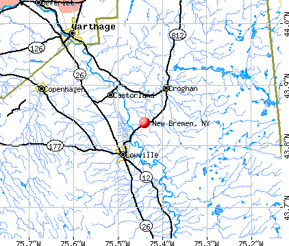
- OSM Map
- General Map
- Google Map
- MSN Map
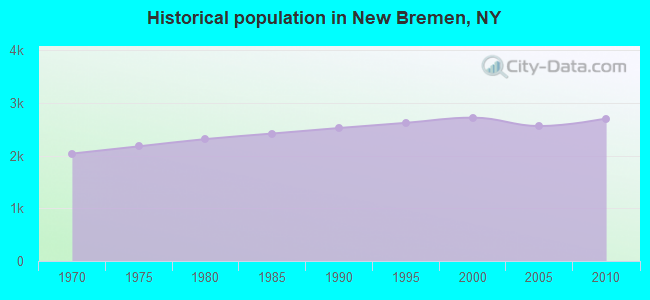
Population change since 2000: -0.6%
 |
| Males: 1,344 | |
| Females: 1,362 |
| Median resident age: | 40.4 years |
| New York median age: | 40.7 years |
Zip codes: 13367.
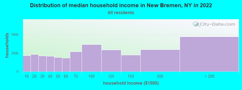
| New Bremen: | $64,546 |
| NY: | $79,557 |
Estimated per capita income in 2022: $29,671 (it was $14,196 in 2000)
New Bremen town income, earnings, and wages data
Estimated median house or condo value in 2022: $161,924 (it was $67,300 in 2000)
| New Bremen: | $161,924 |
| NY: | $400,400 |
Mean prices in 2022: all housing units: $195,982; detached houses: $185,821; townhouses or other attached units: $343,653; in 2-unit structures: $649,528; in 3-to-4-unit structures: $681,838; in 5-or-more-unit structures: $414,780; mobile homes: $75,743
Detailed information about poverty and poor residents in New Bremen, NY


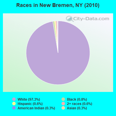
- 2,63397.3%White alone
- 220.8%Black alone
- 160.6%Two or more races
- 170.6%Hispanic
- 90.3%American Indian alone
- 70.3%Asian alone
- 10.04%Native Hawaiian and Other
Pacific Islander alone - 10.04%Other race alone
Races in New Bremen detailed stats: ancestries, foreign born residents, place of birth
 Recent articles from our blog. Our writers, many of them Ph.D. graduates or candidates, create easy-to-read articles on a wide variety of topics.

 | Relocating to PA, NY, VT, NH, or ME - any input? (8 replies) |
| Pa or NYS? (25 replies) |
| Moving to New York State, a few questions (30 replies) |
| Fort Drum area (17 replies) |
| Syracuse Chat thread (6339 replies) |
Latest news from New Bremen, NY collected exclusively by city-data.com from local newspapers, TV, and radio stations
Ancestries: German (47.2%), French (19.1%), Irish (12.2%), English (3.9%), Italian (3.0%), Polish (2.6%).
Current Local Time: EST time zone
Land area: 55.5 square miles.
Population density: 49 people per square mile (very low).
27 residents are foreign born
| This town: | 1.0% |
| New York: | 20.4% |
| New Bremen town: | 1.7% ($1,127) |
| New York: | 1.9% ($2,847) |
Nearest city with pop. 50,000+: Utica, NY  (52.8 miles , pop. 60,651).
Nearest city with pop. 200,000+: Rochester, NY (122.0 miles , pop. 219,773).
Nearest city with pop. 1,000,000+: Bronx, NY (221.6 miles , pop. 1,332,650).
Nearest cities:
), ), ), ), ), ), )Latitude: 43.85 N, Longitude: 75.37 W
Area code commonly used in this area: 315
| Here: | 5.6% |
| New York: | 4.4% |
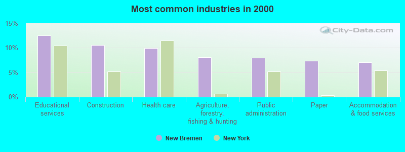
- Educational services (12.5%)
- Construction (10.5%)
- Health care (9.9%)
- Agriculture, forestry, fishing & hunting (8.1%)
- Public administration (8.0%)
- Paper (7.3%)
- Accommodation & food services (7.1%)
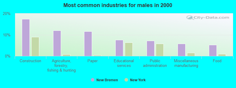
- Construction (17.4%)
- Agriculture, forestry, fishing & hunting (12.0%)
- Paper (11.6%)
- Educational services (7.6%)
- Public administration (7.1%)
- Miscellaneous manufacturing (5.7%)
- Food (5.3%)
- Health care (19.6%)
- Educational services (18.3%)
- Accommodation & food services (10.3%)
- Public administration (9.0%)
- Miscellaneous manufacturing (5.5%)
- Food (4.6%)
- Social assistance (4.6%)
- Other production occupations, including supervisors (9.7%)
- Driver/sales workers and truck drivers (3.9%)
- Preschool, kindergarten, elementary, and middle school teachers (3.7%)
- Carpenters (3.4%)
- Secretaries and administrative assistants (3.3%)
- Farmers and farm managers (3.1%)
- Other office and administrative support workers, including supervisors (3.1%)
- Other production occupations, including supervisors (12.9%)
- Driver/sales workers and truck drivers (6.7%)
- Carpenters (6.4%)
- Farmers and farm managers (4.8%)
- Fishing, hunting, and forestry occupations (3.4%)
- Other management occupations, except farmers and farm managers (3.3%)
- Agricultural workers, including supervisors (3.3%)
- Secretaries and administrative assistants (7.1%)
- Nursing, psychiatric, and home health aides (6.0%)
- Other production occupations, including supervisors (5.9%)
- Cashiers (5.5%)
- Preschool, kindergarten, elementary, and middle school teachers (5.1%)
- Registered nurses (4.9%)
- Cooks and food preparation workers (4.4%)
Average climate in New Bremen, New York
Based on data reported by over 4,000 weather stations


(lower is better)
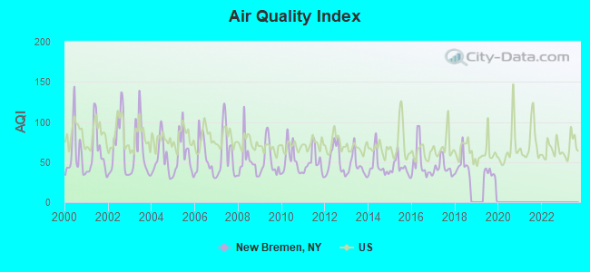
Air Quality Index (AQI) level in 2019 was 32.1. This is significantly better than average.
| City: | 32.1 |
| U.S.: | 72.6 |
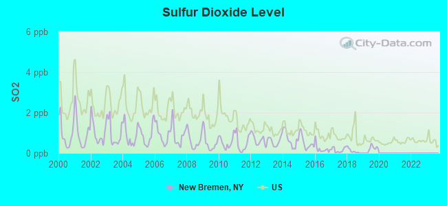
Sulfur Dioxide (SO2) [ppb] level in 2019 was 0.271. This is significantly better than average. Closest monitor was 22.5 miles away from the city center.
| City: | 0.271 |
| U.S.: | 1.515 |
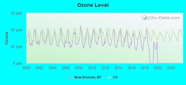
Ozone [ppb] level in 2019 was 20.8. This is significantly better than average. Closest monitor was 22.5 miles away from the city center.
| City: | 20.8 |
| U.S.: | 33.3 |
Earthquake activity:
New Bremen-area historical earthquake activity is significantly above New York state average. It is 69% smaller than the overall U.S. average.On 10/7/1983 at 10:18:46, a magnitude 5.3 (5.1 MB, 5.3 LG, 5.1 ML, Class: Moderate, Intensity: VI - VII) earthquake occurred 51.8 miles away from the city center
On 4/20/2002 at 10:50:47, a magnitude 5.3 (5.3 ML, Depth: 3.0 mi) earthquake occurred 94.8 miles away from the city center
On 4/20/2002 at 10:50:47, a magnitude 5.2 (5.2 MB, 4.2 MS, 5.2 MW, 5.0 MW) earthquake occurred 93.0 miles away from New Bremen center
On 1/19/1982 at 00:14:42, a magnitude 4.7 (4.5 MB, 4.7 MD, 4.5 LG, Class: Light, Intensity: IV - V) earthquake occurred 190.3 miles away from the city center
On 6/17/1991 at 08:53:16, a magnitude 4.1 (4.0 MB, 4.0 LG, Depth: 3.1 mi) earthquake occurred 91.5 miles away from the city center
On 9/25/1998 at 19:52:52, a magnitude 5.2 (4.8 MB, 4.3 MS, 5.2 LG, 4.5 MW, Depth: 3.1 mi) earthquake occurred 303.2 miles away from New Bremen center
Magnitude types: regional Lg-wave magnitude (LG), body-wave magnitude (MB), duration magnitude (MD), local magnitude (ML), surface-wave magnitude (MS), moment magnitude (MW)
Natural disasters:
The number of natural disasters in Lewis County (21) is greater than the US average (15).Major Disasters (Presidential) Declared: 11
Emergencies Declared: 9
Causes of natural disasters: Floods: 7, Storms: 7, Winter Storms: 4, Snowstorms: 3, Hurricanes: 2, Snows: 2, Winds: 2, Blizzard: 1, Power Outage: 1, Tornado: 1, Other: 2 (Note: some incidents may be assigned to more than one category).
Hospitals and medical centers near New Bremen:
- LEWIS COUNTY PUB HEALTH CHHA (Home Health Center, about 8 miles away; LOWVILLE, NY)
- LEWIS COUNTY GENERAL HOSPITAL Acute Care Hospitals (about 8 miles away; LOWVILLE, NY)
- LEWIS COUNTY HOSPICE (Hospital, about 8 miles away; LOWVILLE, NY)
- THE COUNTRY MANOR NURSING AND REHAB CTR (Nursing Home, about 15 miles away; CARTHAGE, NY)
- CARTHAGE AREA HOSPITAL, INC Acute Care Hospitals (about 15 miles away; CARTHAGE, NY)
Airports located in New Bremen:
- Duflo Airport (NY10) (Runways: 2, Air Taxi Ops: 400, Itinerant Ops: 900, Local Ops: 3,500, Military Ops: 200)
Colleges/universities with over 2000 students nearest to New Bremen:
- Jefferson Community College (about 30 miles; Watertown, NY; Full-time enrollment: 2,886)
- St Lawrence University (about 53 miles; Canton, NY; FT enrollment: 2,501)
- Utica College (about 53 miles; Utica, NY; FT enrollment: 2,952)
- SUNY College of Technology at Canton (about 54 miles; Canton, NY; FT enrollment: 3,411)
- Mohawk Valley Community College (about 55 miles; Utica, NY; FT enrollment: 5,693)
- Clarkson University (about 60 miles; Potsdam, NY; FT enrollment: 3,472)
- SUNY College at Potsdam (about 60 miles; Potsdam, NY; FT enrollment: 4,307)
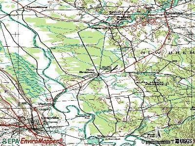
Points of interest:
Notable locations in New Bremen: Hall Dale Acres (A), Moser Farm (B), Bushs Corners (C), New Bremen Fire Department (D). Display/hide their locations on the map
Church in New Bremen: Saint Peters Church (A). Display/hide its location on the map
Lakes and reservoirs: Crystal Pond (A), Lowville Reservoir (B). Display/hide their locations on the map
Creeks: Butler Creek (A), Crystal Creek (B), Sandy Creek (C), Capidon Creek (D). Display/hide their locations on the map
| This town: | 2.7 people |
| New York: | 2.6 people |
| This town: | 76.5% |
| Whole state: | 63.5% |
| This town: | 6.5% |
| Whole state: | 6.8% |
Likely homosexual households (counted as self-reported same-sex unmarried-partner households)
- Lesbian couples: 0.2% of all households
- Gay men: 0.2% of all households
| This town: | 11.1% |
| Whole state: | 14.6% |
| This town: | 3.3% |
| Whole state: | 7.4% |
For population 15 years and over in New Bremen:
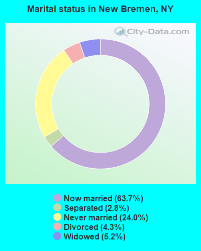
- Never married: 24.0%
- Now married: 63.7%
- Separated: 2.8%
- Widowed: 5.2%
- Divorced: 4.3%
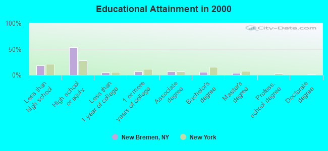
For population 25 years and over in New Bremen:
- High school or higher: 81.9%
- Bachelor's degree or higher: 10.6%
- Graduate or professional degree: 4.3%
- Unemployed: 8.4%
- Mean travel time to work (commute): 19.6 minutes
| Here: | 8.6 |
| New York average: | 14.2 |
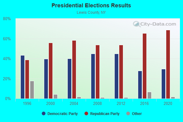
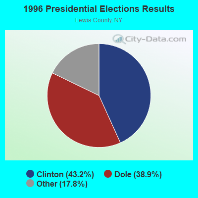
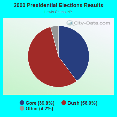
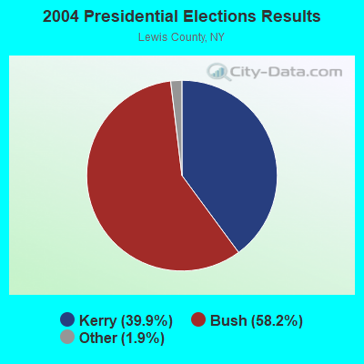
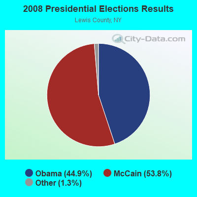
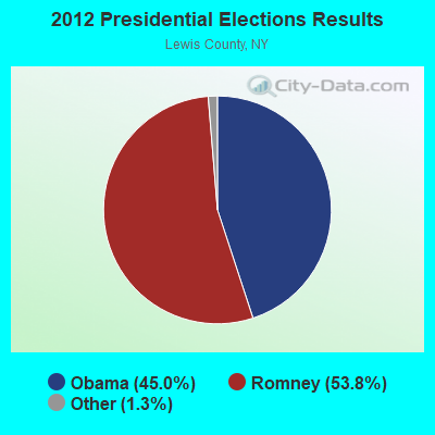
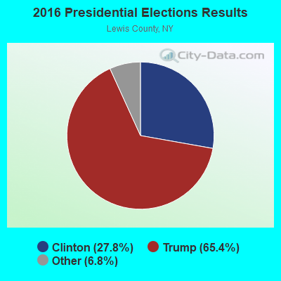
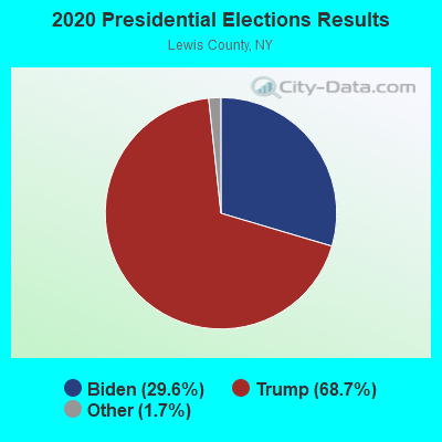
Graphs represent county-level data. Detailed 2008 Election Results
Religion statistics for New Bremen, NY (based on Lewis County data)
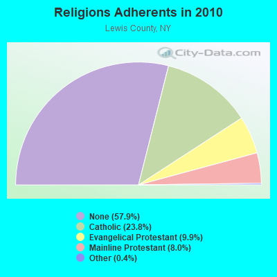
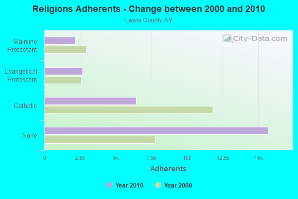
| Religion | Adherents | Congregations |
|---|---|---|
| Catholic | 6,443 | 17 |
| Evangelical Protestant | 2,693 | 21 |
| Mainline Protestant | 2,155 | 25 |
| Other | 115 | 1 |
| None | 15,681 | - |
Food Environment Statistics:
| This county: | 3.41 / 10,000 pop. |
| State: | 4.13 / 10,000 pop. |
| Lewis County: | 4.92 / 10,000 pop. |
| New York: | 1.68 / 10,000 pop. |
| Here: | 10.61 / 10,000 pop. |
| New York: | 8.82 / 10,000 pop. |
| This county: | 9.6% |
| State: | 8.2% |
| Lewis County: | 27.4% |
| New York: | 23.8% |
| Here: | 13.4% |
| New York: | 15.6% |
Strongest AM radio stations in New Bremen:
- WGY (810 AM; 50 kW; SCHENECTADY, NY; Owner: CLEAR CHANNEL BROADCASTING LICENSES, INC.)
- WNER (1410 AM; 5 kW; WATERTOWN, NY)
- WICY (1490 AM; 50 kW; MALONE, NY; Owner: CARTIER COMMUNICATIONS INC.)
- WCHP (760 AM; 35 kW; CHAMPLAIN, NY; Owner: CHAMPLAIN RADIO, INC.)
- WPTR (1540 AM; 50 kW; ALBANY, NY; Owner: KIMTRON, INC.)
- WHAM (1180 AM; 50 kW; ROCHESTER, NY; Owner: CITICASTERS LICENSES, L.P.)
- WADR (1480 AM; 5 kW; REMSEN, NY; Owner: CLEAR CHANNEL BROADCASTING LICENSES, INC.)
- WNNZ (640 AM; 50 kW; WESTFIELD, MA; Owner: CLEAR CHANNEL BROADCASTING LICENSES, INC.)
- WRUN (1150 AM; 5 kW; UTICA, NY)
- WBRV (900 AM; 1 kW; BOONVILLE, NY)
- WIBX (950 AM; 5 kW; UTICA, NY; Owner: REGENT LICENSEE OF UTICA/ROME, INC.)
- WHEN (620 AM; 5 kW; SYRACUSE, NY; Owner: CLEAR CHANNEL BROADCASTING LICENSES, INC.)
- WMCA (570 AM; 50 kW; NEW YORK, NY; Owner: SALEM MEDIA OF NEW YORK, LLC)
Strongest FM radio stations in New Bremen:
- WBDI (106.7 FM; COPENHAGEN, NY; Owner: FORCE COMMUNICATIONS, INC)
- WJNY (90.9 FM; WATERTOWN, NY; Owner: PUBLIC B/CNG COUNCIL CENTRAL NY, INC)
- WLLG (99.3 FM; LOWVILLE, NY; Owner: THE FLACK BROADCASTING GROUP L.L.C.)
- WFRY-FM (97.5 FM; WATERTOWN, NY; Owner: REGENT LICENSEE OF WATERTOWN, INC.)
- WTOJ (103.1 FM; CARTHAGE, NY; Owner: CLANCY-MANCE COMMUNICATIONS, INC.)
- WXLH (91.3 FM; BLUE MOUNTAIN LAKE, NY; Owner: THE ST. LAWRENCE UNIVERSITY)
- WWJS (90.1 FM; WATERTOWN, NY; Owner: LIBERTY COMMUNICATIONS FAMILY B/G)
- WRGR (102.3 FM; TUPPER LAKE, NY; Owner: RADIO LAKE PLACID, INC.)
- WUCL (93.5 FM; REMSEN, NY; Owner: CLEAR CHANNEL BROADCASTING LICENSES, INC.)
- WSLJ (88.9 FM; WATERTOWN, NY; Owner: THE ST. LAWRENCE UNIVERSITY)
- WRVJ (91.7 FM; WATERTOWN, NY; Owner: STATE UNIVERSITY OF NEW YORK)
- W261CP (100.1 FM; LOWVILLE, NY; Owner: ENNIS COMMUNICATIONS COMPANY)
- W201CB (88.1 FM; LOWVILLE, NY; Owner: THE ST. LAWRENCE UNIVERSITY)
- W220BO (91.9 FM; LOWVILLE, NY; Owner: BLACK RIVER VALLEY GOSPEL RADIO, INC)
TV broadcast stations around New Bremen:
- WWTI (Channel 50; WATERTOWN, NY; Owner: CENTRAL NY NEWS, INC.)
- WPBS-TV (Channel 16; WATERTOWN, NY; Owner: ST. LAWRENCE VALLEY EDUCATIONAL TV COUNCIL, INC)
- WWNY-TV (Channel 7; CARTHAGE, NY; Owner: UNITED COMMUNICATIONS CORPORATION)
- National Bridge Inventory (NBI) Statistics
- 6Number of bridges
- 89ft / 26.9mTotal length
- $10,843,000Total costs
- 12,080Total average daily traffic
- 1,043Total average daily truck traffic
- 12,909Total future (year 2036) average daily traffic
FCC Registered Broadcast Land Mobile Towers:
1- Beech Hill 4 Mi E (Lat: 43.838667 Lon: -75.360750), Call Sign: KED887,
Assigned Frequencies: 42.1400 MHz, 154.695 MHz, 155.475 MHz, 155.505 MHz, 155.565 MHz, Grant Date: 01/07/2022, Expiration Date: 03/19/2032, Registrant: New York State Police, 1220 Washington Ave, Bldg 22, Albany, NY 12226-2252, Phone: (518) 457-9466, Fax: (518) 457-5676, Email:
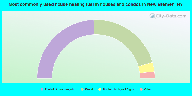
- 48.8%Fuel oil, kerosene, etc.
- 42.4%Wood
- 5.1%Bottled, tank, or LP gas
- 2.6%Utility gas
- 1.2%Electricity
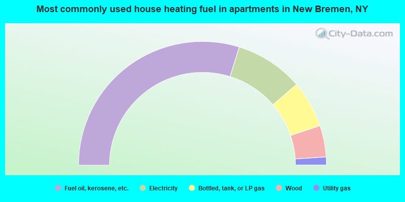
- 59.6%Fuel oil, kerosene, etc.
- 17.8%Electricity
- 12.3%Bottled, tank, or LP gas
- 8.2%Wood
- 2.1%Utility gas
New Bremen compared to New York state average:
- Median house value significantly below state average.
- Unemployed percentage below state average.
- Black race population percentage significantly below state average.
- Hispanic race population percentage significantly below state average.
- Foreign-born population percentage significantly below state average.
- Renting percentage significantly below state average.
- Length of stay since moving in significantly above state average.
- Number of rooms per house significantly below state average.
- House age significantly below state average.
- Number of college students significantly below state average.
- Percentage of population with a bachelor's degree or higher significantly below state average.