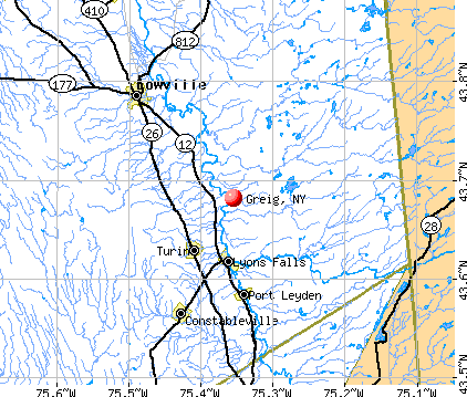
Greig, New York
Submit your own pictures of this town and show them to the world
- OSM Map
- General Map
- Google Map
- MSN Map
Population change since 2000: -12.2%
 |
| Males: 618 | |
| Females: 581 |
| Median resident age: | 45.4 years |
| New York median age: | 40.7 years |
Zip codes: 13312.
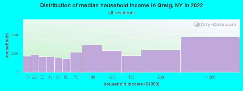
| Greig: | $64,452 |
| NY: | $79,557 |
Estimated per capita income in 2022: $33,103 (it was $15,838 in 2000)
Greig town income, earnings, and wages data
Estimated median house or condo value in 2022: $170,586 (it was $70,900 in 2000)
| Greig: | $170,586 |
| NY: | $400,400 |
Mean prices in 2022: all housing units: $195,982; detached houses: $185,821; townhouses or other attached units: $343,653; in 2-unit structures: $649,528; in 3-to-4-unit structures: $681,838; in 5-or-more-unit structures: $414,780; mobile homes: $75,743
Detailed information about poverty and poor residents in Greig, NY


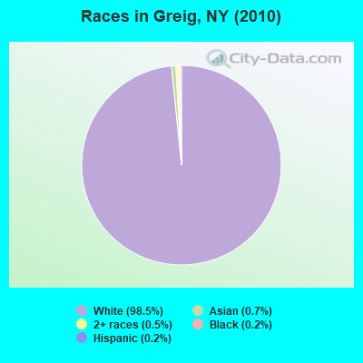
- 1,18198.5%White alone
- 80.7%Asian alone
- 60.5%Two or more races
- 20.2%Black alone
- 20.2%Hispanic
Races in Greig detailed stats: ancestries, foreign born residents, place of birth
 Recent articles from our blog. Our writers, many of them Ph.D. graduates or candidates, create easy-to-read articles on a wide variety of topics.

 | For those interested in Technology and Economic activity in Upstate NY... (2811 replies) |
| New food court opens in Troy, featuring Mazzone, Stacks Coffee (0 replies) |
| 15 great small Upstate NY towns with less than 1000 people (7 replies) |
| Occupy Wall St (813 replies) |
| Pa or NYS? (25 replies) |
Latest news from Greig, NY collected exclusively by city-data.com from local newspapers, TV, and radio stations
Ancestries: Irish (19.0%), German (15.4%), French (14.6%), United States (12.9%), English (10.3%), Hungarian (7.5%).
Current Local Time: EST time zone
Land area: 92.9 square miles.
Population density: 13 people per square mile (very low).

11 residents are foreign born
| This town: | 0.8% |
| New York: | 20.4% |
| Greig town: | 1.9% ($1,366) |
| New York: | 1.9% ($2,847) |
Nearest city with pop. 50,000+: Utica, NY  (41.7 miles , pop. 60,651).
Nearest city with pop. 200,000+: Rochester, NY (121.2 miles , pop. 219,773).
Nearest city with pop. 1,000,000+: Bronx, NY (210.5 miles , pop. 1,332,650).
Nearest cities:
), ), ), ), )Latitude: 43.70 N, Longitude: 75.31 W
Area code commonly used in this area: 315

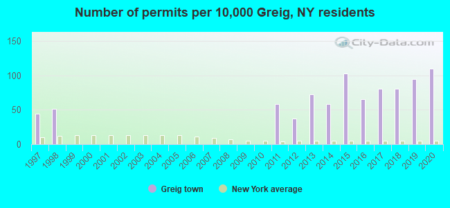
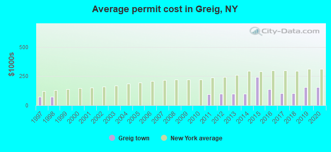
Single-family new house construction building permits:
- 2020: 15 buildings, average cost: $156,800
- 2019: 13 buildings, average cost: $156,800
- 2018: 11 buildings, average cost: $103,500
- 2017: 11 buildings, average cost: $103,500
- 2016: 9 buildings, average cost: $137,200
- 2015: 14 buildings, average cost: $241,600
- 2014: 8 buildings, average cost: $100,000
- 2013: 10 buildings, average cost: $100,000
- 2012: 5 buildings, average cost: $100,000
- 2011: 8 buildings, average cost: $93,800
- 1998: 7 buildings, average cost: $75,000
- 1997: 6 buildings, average cost: $75,000
| Here: | 5.6% |
| New York: | 4.4% |
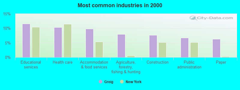
- Educational services (11.6%)
- Health care (10.3%)
- Accommodation & food services (9.8%)
- Agriculture, forestry, fishing & hunting (8.0%)
- Construction (7.6%)
- Public administration (6.7%)
- Paper (6.3%)
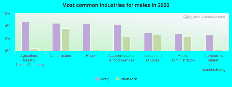
- Agriculture, forestry, fishing & hunting (11.6%)
- Construction (11.0%)
- Paper (10.7%)
- Accommodation & food services (10.4%)
- Educational services (7.2%)
- Public administration (6.9%)
- Furniture & related product manufacturing (6.3%)
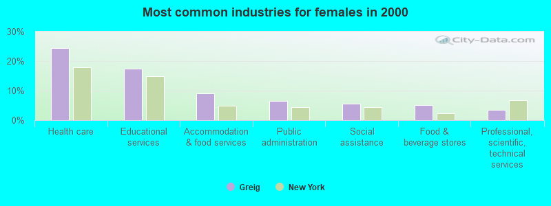
- Health care (24.4%)
- Educational services (17.5%)
- Accommodation & food services (9.0%)
- Public administration (6.4%)
- Social assistance (5.6%)
- Food & beverage stores (5.1%)
- Professional, scientific, technical services (3.4%)
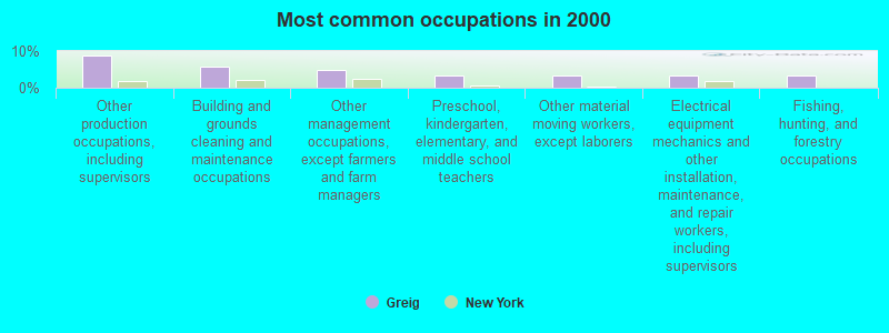
- Other production occupations, including supervisors (8.9%)
- Building and grounds cleaning and maintenance occupations (5.6%)
- Other management occupations, except farmers and farm managers (4.7%)
- Preschool, kindergarten, elementary, and middle school teachers (3.4%)
- Other material moving workers, except laborers (3.4%)
- Electrical equipment mechanics and other installation, maintenance, and repair workers, including supervisors (3.4%)
- Fishing, hunting, and forestry occupations (3.3%)
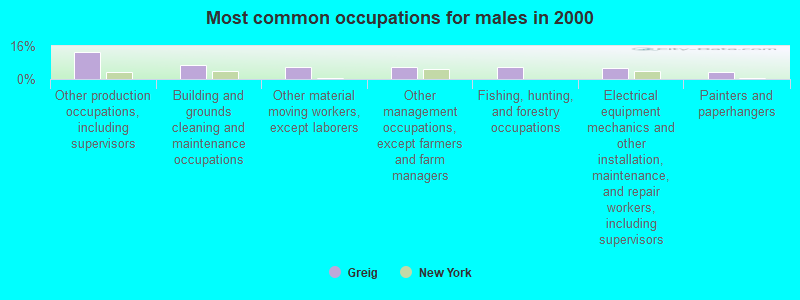
- Other production occupations, including supervisors (13.2%)
- Building and grounds cleaning and maintenance occupations (6.6%)
- Other material moving workers, except laborers (6.0%)
- Other management occupations, except farmers and farm managers (5.7%)
- Fishing, hunting, and forestry occupations (5.7%)
- Electrical equipment mechanics and other installation, maintenance, and repair workers, including supervisors (5.3%)
- Painters and paperhangers (3.5%)
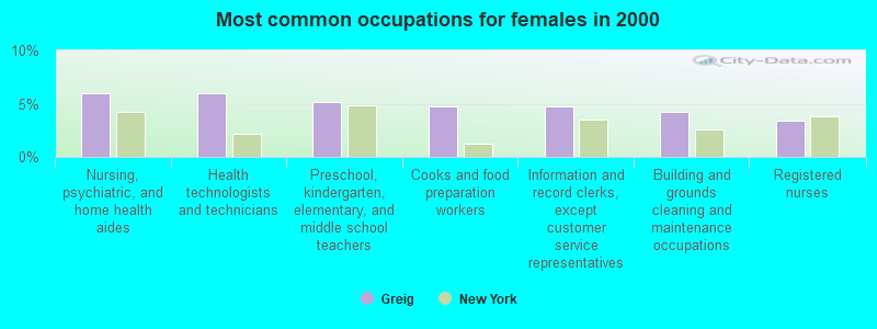
- Nursing, psychiatric, and home health aides (6.0%)
- Health technologists and technicians (6.0%)
- Preschool, kindergarten, elementary, and middle school teachers (5.1%)
- Cooks and food preparation workers (4.7%)
- Information and record clerks, except customer service representatives (4.7%)
- Building and grounds cleaning and maintenance occupations (4.3%)
- Registered nurses (3.4%)
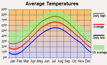
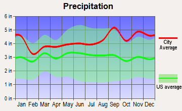
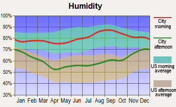
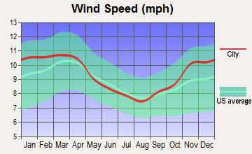
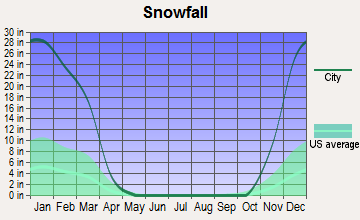
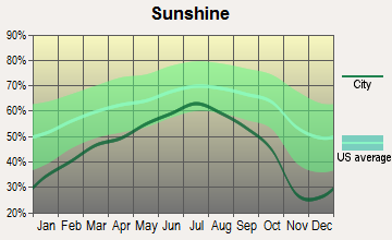
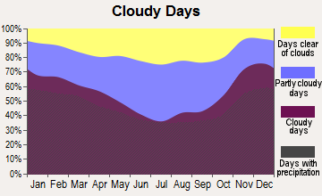
Average climate in Greig, New York
Based on data reported by over 4,000 weather stations
(lower is better)
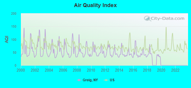
Air Quality Index (AQI) level in 2019 was 32.1. This is significantly better than average.
| City: | 32.1 |
| U.S.: | 72.6 |
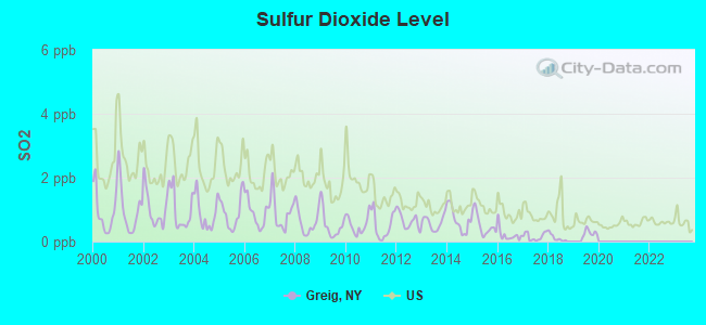
Sulfur Dioxide (SO2) [ppb] level in 2019 was 0.271. This is significantly better than average. Closest monitor was 16.4 miles away from the city center.
| City: | 0.271 |
| U.S.: | 1.515 |
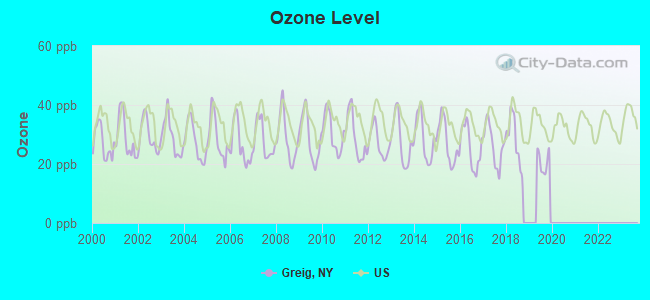
Ozone [ppb] level in 2019 was 20.8. This is significantly better than average. Closest monitor was 16.4 miles away from the city center.
| City: | 20.8 |
| U.S.: | 33.3 |
Earthquake activity:
Greig-area historical earthquake activity is significantly above New York state average. It is 69% smaller than the overall U.S. average.On 10/7/1983 at 10:18:46, a magnitude 5.3 (5.1 MB, 5.3 LG, 5.1 ML, Class: Moderate, Intensity: VI - VII) earthquake occurred 51.6 miles away from Greig center
On 4/20/2002 at 10:50:47, a magnitude 5.3 (5.3 ML, Depth: 3.0 mi) earthquake occurred 98.0 miles away from Greig center
On 4/20/2002 at 10:50:47, a magnitude 5.2 (5.2 MB, 4.2 MS, 5.2 MW, 5.0 MW) earthquake occurred 96.2 miles away from Greig center
On 1/19/1982 at 00:14:42, a magnitude 4.7 (4.5 MB, 4.7 MD, 4.5 LG, Class: Light, Intensity: IV - V) earthquake occurred 186.4 miles away from the city center
On 6/17/1991 at 08:53:16, a magnitude 4.1 (4.0 MB, 4.0 LG, Depth: 3.1 mi) earthquake occurred 80.5 miles away from Greig center
On 9/25/1998 at 19:52:52, a magnitude 5.2 (4.8 MB, 4.3 MS, 5.2 LG, 4.5 MW, Depth: 3.1 mi) earthquake occurred 300.4 miles away from Greig center
Magnitude types: regional Lg-wave magnitude (LG), body-wave magnitude (MB), duration magnitude (MD), local magnitude (ML), surface-wave magnitude (MS), moment magnitude (MW)
Natural disasters:
The number of natural disasters in Lewis County (21) is greater than the US average (15).Major Disasters (Presidential) Declared: 11
Emergencies Declared: 9
Causes of natural disasters: Floods: 7, Storms: 7, Winter Storms: 4, Snowstorms: 3, Hurricanes: 2, Snows: 2, Winds: 2, Blizzard: 1, Power Outage: 1, Tornado: 1, Other: 2 (Note: some incidents may be assigned to more than one category).
Hospitals and medical centers near Greig:
- LEWIS COUNTY PUB HEALTH CHHA (Home Health Center, about 12 miles away; LOWVILLE, NY)
- LEWIS COUNTY GENERAL HOSPITAL Acute Care Hospitals (about 12 miles away; LOWVILLE, NY)
- LEWIS COUNTY HOSPICE (Hospital, about 12 miles away; LOWVILLE, NY)
- SUNSET NURSING HOME INC (Nursing Home, about 16 miles away; BOONVILLE, NY)
Colleges/universities with over 2000 students nearest to Greig:
- Jefferson Community College (about 38 miles; Watertown, NY; Full-time enrollment: 2,886)
- Utica College (about 42 miles; Utica, NY; FT enrollment: 2,952)
- Mohawk Valley Community College (about 44 miles; Utica, NY; FT enrollment: 5,693)
- Herkimer County Community College (about 49 miles; Herkimer, NY; FT enrollment: 2,774)
- Morrisville State College (about 58 miles; Morrisville, NY; FT enrollment: 2,823)
- Le Moyne College (about 60 miles; Syracuse, NY; FT enrollment: 3,041)
- Syracuse University (about 62 miles; Syracuse, NY; FT enrollment: 20,717)
Points of interest:
Churches in Greig include: Saint Thomas Church (A), Calvary Bible Church (B). Display/hide their locations on the map
Cemeteries: Brantingham Cemetery (1), Sands Cemetery (2). Display/hide their locations on the map
Lakes: Little Otter Lake (A), Little Pine Lake (B), Lost Lake (C), Mudhole Pond (D), Pine Lake (E), Pleasant Lake (F), Sand Pond (G), West Pine Pond (H). Display/hide their locations on the map
Creeks: Otter Creek (A), Yellow Creek (B), Emerson Creek (C), Fish Creek (D), Drunkard Creek (E), Tommy Roaring Creek (F), Crooked Creek (G), Middle Branch Pine Creek (H), Little Pine Creek (I). Display/hide their locations on the map
Park in Greig: Singing Waters Park (1). Display/hide its location on the map
Birthplace of: Caleb Lyon - Politician.
| This town: | 2.4 people |
| New York: | 2.6 people |
| This town: | 69.3% |
| Whole state: | 63.5% |
| This town: | 8.2% |
| Whole state: | 6.8% |
Likely homosexual households (counted as self-reported same-sex unmarried-partner households)
- Lesbian couples: 0.2% of all households
- Gay men: 0.4% of all households
| This town: | 8.9% |
| Whole state: | 14.6% |
| This town: | 3.0% |
| Whole state: | 7.4% |
For population 15 years and over in Greig:
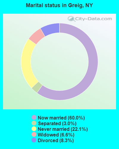
- Never married: 22.1%
- Now married: 60.0%
- Separated: 3.0%
- Widowed: 6.6%
- Divorced: 8.3%
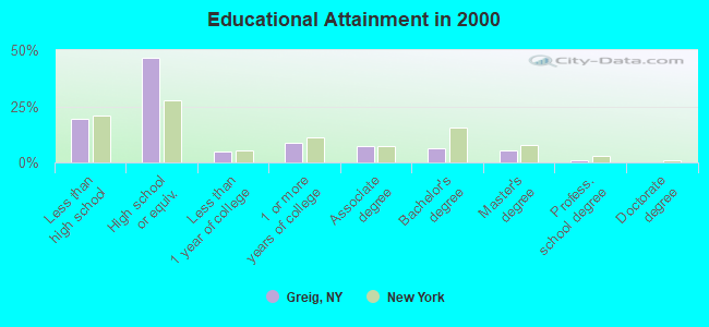
For population 25 years and over in Greig:
- High school or higher: 80.4%
- Bachelor's degree or higher: 13.1%
- Graduate or professional degree: 6.5%
- Unemployed: 8.0%
- Mean travel time to work (commute): 25.2 minutes
| Here: | 9.8 |
| New York average: | 14.2 |
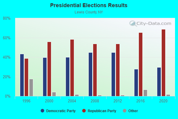
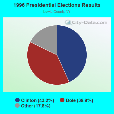
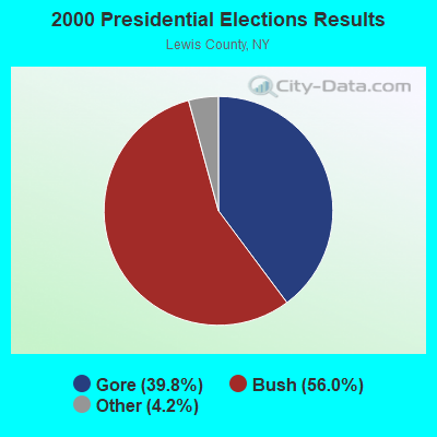
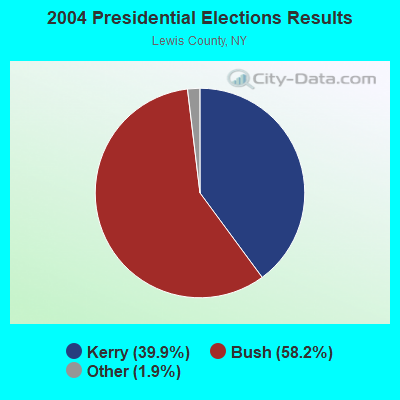
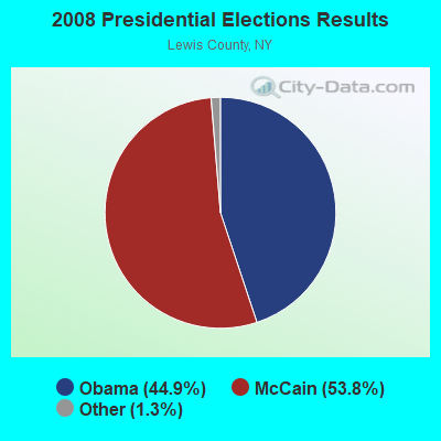
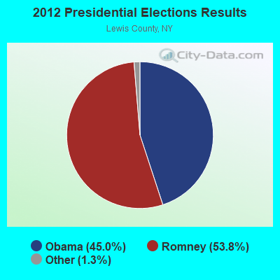
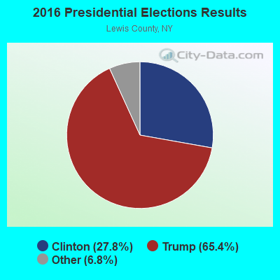
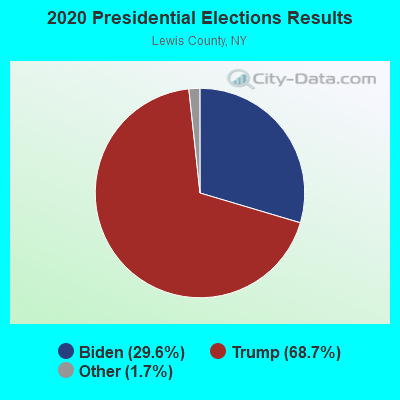
Graphs represent county-level data. Detailed 2008 Election Results
Religion statistics for Greig, NY (based on Lewis County data)
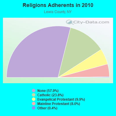
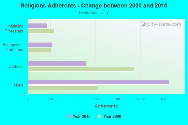
| Religion | Adherents | Congregations |
|---|---|---|
| Catholic | 6,443 | 17 |
| Evangelical Protestant | 2,693 | 21 |
| Mainline Protestant | 2,155 | 25 |
| Other | 115 | 1 |
| None | 15,681 | - |
Food Environment Statistics:
| Here: | 3.41 / 10,000 pop. |
| New York: | 4.13 / 10,000 pop. |
| Lewis County: | 4.92 / 10,000 pop. |
| State: | 1.68 / 10,000 pop. |
| This county: | 10.61 / 10,000 pop. |
| State: | 8.82 / 10,000 pop. |
| This county: | 9.6% |
| New York: | 8.2% |
| Here: | 27.4% |
| New York: | 23.8% |
| Lewis County: | 13.4% |
| State: | 15.6% |
Strongest AM radio stations in Greig:
- WGY (810 AM; 50 kW; SCHENECTADY, NY; Owner: CLEAR CHANNEL BROADCASTING LICENSES, INC.)
- WBRV (900 AM; 1 kW; BOONVILLE, NY)
- WADR (1480 AM; 5 kW; REMSEN, NY; Owner: CLEAR CHANNEL BROADCASTING LICENSES, INC.)
- WICY (1490 AM; 50 kW; MALONE, NY; Owner: CARTIER COMMUNICATIONS INC.)
- WPTR (1540 AM; 50 kW; ALBANY, NY; Owner: KIMTRON, INC.)
- WRUN (1150 AM; 5 kW; UTICA, NY)
- WNER (1410 AM; 5 kW; WATERTOWN, NY)
- WIBX (950 AM; 5 kW; UTICA, NY; Owner: REGENT LICENSEE OF UTICA/ROME, INC.)
- WCHP (760 AM; 35 kW; CHAMPLAIN, NY; Owner: CHAMPLAIN RADIO, INC.)
- WNNZ (640 AM; 50 kW; WESTFIELD, MA; Owner: CLEAR CHANNEL BROADCASTING LICENSES, INC.)
- WHAM (1180 AM; 50 kW; ROCHESTER, NY; Owner: CITICASTERS LICENSES, L.P.)
- WHEN (620 AM; 5 kW; SYRACUSE, NY; Owner: CLEAR CHANNEL BROADCASTING LICENSES, INC.)
- WTLB (1310 AM; 5 kW; UTICA, NY; Owner: GALAXY COMMUNICATIONS, L.P.)
Strongest FM radio stations in Greig:
- WLLG (99.3 FM; LOWVILLE, NY; Owner: THE FLACK BROADCASTING GROUP L.L.C.)
- WBDI (106.7 FM; COPENHAGEN, NY; Owner: FORCE COMMUNICATIONS, INC)
- WJNY (90.9 FM; WATERTOWN, NY; Owner: PUBLIC B/CNG COUNCIL CENTRAL NY, INC)
- WUCL (93.5 FM; REMSEN, NY; Owner: CLEAR CHANNEL BROADCASTING LICENSES, INC.)
- WXLH (91.3 FM; BLUE MOUNTAIN LAKE, NY; Owner: THE ST. LAWRENCE UNIVERSITY)
- WFRY-FM (97.5 FM; WATERTOWN, NY; Owner: REGENT LICENSEE OF WATERTOWN, INC.)
- WBRV-FM (101.3 FM; BOONVILLE, NY; Owner: THE FLACK BROADCASTING GROUP L.L.C.)
- WTOJ (103.1 FM; CARTHAGE, NY; Owner: CLANCY-MANCE COMMUNICATIONS, INC.)
- WRGR (102.3 FM; TUPPER LAKE, NY; Owner: RADIO LAKE PLACID, INC.)
- WWJS (90.1 FM; WATERTOWN, NY; Owner: LIBERTY COMMUNICATIONS FAMILY B/G)
- WOUR (96.9 FM; UTICA, NY; Owner: CLEAR CHANNEL BROADCASTING LICENSES, INC.)
- WUNY (89.5 FM; UTICA, NY; Owner: PUBLIC BC COUNCIL OF CENTRAL NY, INC)
- WODZ-FM (96.1 FM; ROME, NY; Owner: REGENT LICENSEE OF UTICA/ROME, INC.)
- W206BH (89.1 FM; LYONS FALLS, NY; Owner: THE ST. LAWRENCE UNIVERSITY)
- W213AR (90.5 FM; LYONS FALLS, NY; Owner: BLACK RIVER VALLEY GOSPEL RADIO, INC)
TV broadcast stations around Greig:
- WWTI (Channel 50; WATERTOWN, NY; Owner: CENTRAL NY NEWS, INC.)
- WPBS-TV (Channel 16; WATERTOWN, NY; Owner: ST. LAWRENCE VALLEY EDUCATIONAL TV COUNCIL, INC)
- WWNY-TV (Channel 7; CARTHAGE, NY; Owner: UNITED COMMUNICATIONS CORPORATION)
- WSPX-TV (Channel 56; SYRACUSE, NY; Owner: PAXSON SYRACUSE LICENSE, INC.)
- Greig, New York
- Fatal accident count9
- Vehicles involved in fatal accidents11
- Fatal accidents involving drunk persons:4
- Fatalities9
- Persons involved in fatal accidents14
- Pedestrians involved in fatal accidents0
- New York average
- Fatal accident count7242
- Vehicles involved in fatal accidents10757
- Fatal accidents involving drunk persons1623
- Fatalities7793
- Persons involved in fatal accidents16835
- Pedestrians involved in fatal accidents2538
- National Bridge Inventory (NBI) Statistics
- 10Number of bridges
- 92ft / 28.3mTotal length
- $8,891,000Total costs
- 4,727Total average daily traffic
- 359Total average daily truck traffic
- 6,617Total future (year 2034) average daily traffic
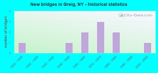
- New bridges - historical statistics
- 11920-1929
- 11950-1959
- 21960-1969
- 31970-1979
- 21980-1989
- 12000-2009
FCC Registered Microwave Towers:
2- Brantingham Rd 2 Mi E Of Greig Rd (Lat: 43.698111 Lon: -75.324611), Overall height: 30.8 m, Call Sign: WNTW730,
Assigned Frequencies: 19137.5 MHz, 19157.5 MHz, Grant Date: 02/16/1995, Expiration Date: 02/16/2000, Cancellation Date: 05/21/2000, Phone: (716) 822-3692
- BRANTINGHAM, Brantingham Rd 2 Mi E Of Greig Rd (Lat: 43.698139 Lon: -75.324611), Type: Tower, Structure height: 30.8 m, Call Sign: WPYE232,
Assigned Frequencies: 19137.5 MHz, 19157.5 MHz, Grant Date: 07/25/2003, Expiration Date: 07/25/2013, Cancellation Date: 09/28/2013, Certifier: John J Mckeown, Registrant: Comsearch, 19700 Janelia Farm Boulevard, Ashburn, VA 20147, Phone: (703) 726-5671, Fax: (703) 726-5594, Email:
FCC Registered Amateur Radio Licenses:
1- Call Sign: KE2BAA, Licensee ID: L02649690, Grant Date: 03/21/2023, Expiration Date: 03/21/2033, Certifier: William E Bourgeois, Registrant: William E Bourgeois, 5655 Van Arnam Rd, Greig, NY 13345
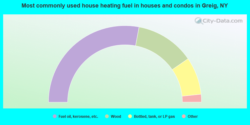
- 55.9%Fuel oil, kerosene, etc.
- 24.9%Wood
- 15.9%Bottled, tank, or LP gas
- 1.8%Electricity
- 0.9%Coal or coke
- 0.7%Other fuel
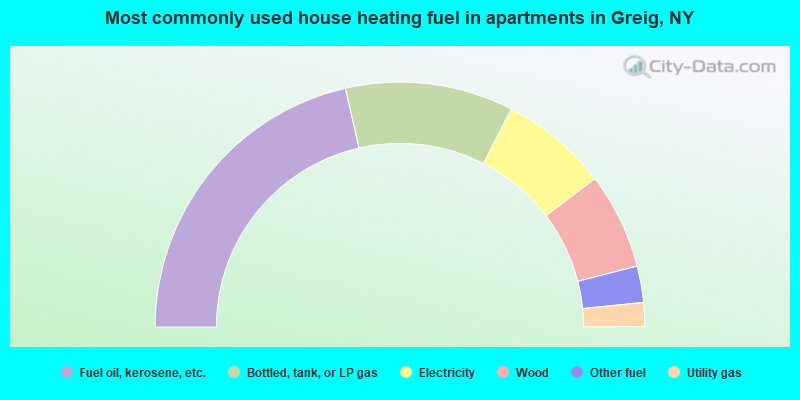
- 42.9%Fuel oil, kerosene, etc.
- 22.2%Bottled, tank, or LP gas
- 14.3%Electricity
- 12.7%Wood
- 4.8%Other fuel
- 3.2%Utility gas
Greig compared to New York state average:
- Median house value significantly below state average.
- Unemployed percentage below state average.
- Black race population percentage significantly below state average.
- Hispanic race population percentage significantly below state average.
- Median age above state average.
- Foreign-born population percentage significantly below state average.
- Renting percentage significantly below state average.
- Length of stay since moving in significantly above state average.
- Number of rooms per house significantly below state average.
- House age significantly below state average.
- Number of college students significantly below state average.
- Percentage of population with a bachelor's degree or higher below state average.