Morrison, Wisconsin
Submit your own pictures of this town and show them to the world
- OSM Map
- General Map
- Google Map
- MSN Map
Population change since 2000: -3.1%
 |
| Males: 821 | |
| Females: 778 |
| Median resident age: | 39.3 years |
| Wisconsin median age: | 42.6 years |
Zip codes: 54126.
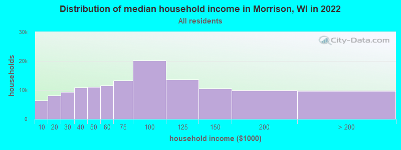
| Morrison: | $84,931 |
| WI: | $70,996 |
Estimated per capita income in 2022: $35,337 (it was $19,841 in 2000)
Morrison town income, earnings, and wages data
Estimated median house or condo value in 2022: $259,060 (it was $119,400 in 2000)
| Morrison: | $259,060 |
| WI: | $252,800 |
Mean prices in 2022: all housing units: $287,597; detached houses: $299,013; townhouses or other attached units: $230,209; in 2-unit structures: $211,638; in 3-to-4-unit structures: $208,261; in 5-or-more-unit structures: $170,104; mobile homes: $72,078
Detailed information about poverty and poor residents in Morrison, WI


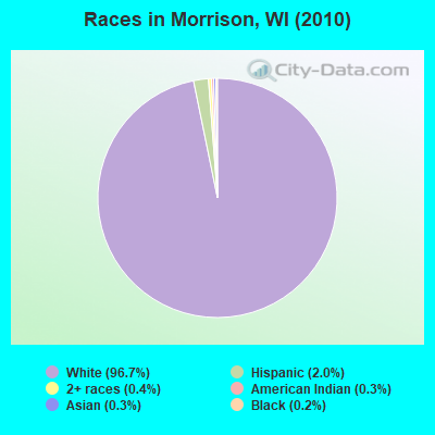
- 1,54796.7%White alone
- 322.0%Hispanic
- 70.4%Two or more races
- 50.3%American Indian alone
- 40.3%Asian alone
- 30.2%Black alone
- 10.06%Other race alone
Races in Morrison detailed stats: ancestries, foreign born residents, place of birth
According to our research of Wisconsin and other state lists, there was 1 registered sex offender living in Morrison, Wisconsin as of May 11, 2024.
The ratio of all residents to sex offenders in Morrison is 1,599 to 1.
The ratio of registered sex offenders to all residents in this city is much lower than the state average.
 Recent articles from our blog. Our writers, many of them Ph.D. graduates or candidates, create easy-to-read articles on a wide variety of topics.

 | $600 Rent in Milwaukee vs New York City Metro Area (27 replies) |
| Dog parks (official and unofficial) (22 replies) |
| Wauwatosa Susceptible to White Flight? (51 replies) |
| Race relations (32 replies) |
| Say Cheeseburger! (24 replies) |
| Driving to Milwaukee from Cleveland (best route to take) (6 replies) |
Latest news from Morrison, WI collected exclusively by city-data.com from local newspapers, TV, and radio stations
Ancestries: German (65.4%), Irish (12.2%), Dutch (7.1%), Czech (5.8%), Polish (5.8%), United States (3.4%).
Current Local Time: CST time zone
Elevation: 919 feet
Land area: 35.1 square miles.
Population density: 46 people per square mile (very low).
16 residents are foreign born
| This town: | 1.0% |
| Wisconsin: | 3.6% |
| Morrison town: | 1.2% ($1,491) |
| Wisconsin: | 2.0% ($2,245) |
Nearest city with pop. 50,000+: Green Bay, WI  (16.3 miles , pop. 102,313).
Nearest city with pop. 200,000+: Milwaukee, WI (85.1 miles , pop. 596,974).
Nearest city with pop. 1,000,000+: Chicago, IL (169.4 miles , pop. 2,896,016).
Nearest cities:
), ), ), ), ), )Latitude: 44.28 N, Longitude: 87.95 W
Area code commonly used in this area: 920

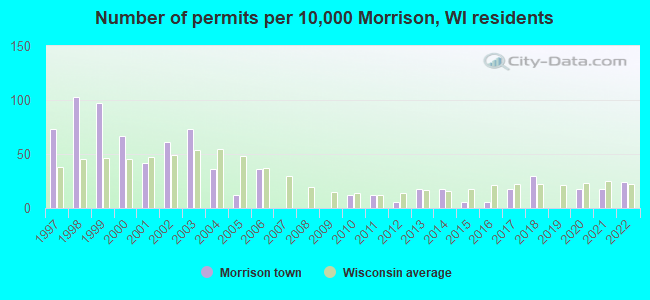
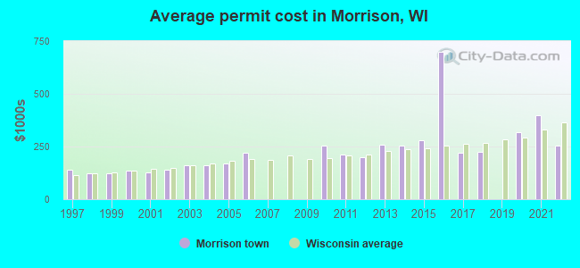
Single-family new house construction building permits:
- 2022: 4 buildings, average cost: $253,800
- 2021: 3 buildings, average cost: $400,000
- 2020: 3 buildings, average cost: $316,700
- 2018: 5 buildings, average cost: $224,900
- 2017: 3 buildings, average cost: $222,000
- 2016: 1 building, cost: $699,000
- 2015: 1 building, cost: $280,000
- 2014: 3 buildings, average cost: $253,200
- 2013: 3 buildings, average cost: $259,500
- 2012: 1 building, cost: $200,000
- 2011: 2 buildings, average cost: $212,500
- 2010: 2 buildings, average cost: $253,500
- 2006: 6 buildings, average cost: $221,700
- 2005: 2 buildings, average cost: $167,500
- 2004: 6 buildings, average cost: $161,500
- 2003: 12 buildings, average cost: $159,200
- 2002: 10 buildings, average cost: $140,200
- 2001: 7 buildings, average cost: $128,600
- 2000: 11 buildings, average cost: $133,600
- 1999: 16 buildings, average cost: $124,500
- 1998: 17 buildings, average cost: $125,000
- 1997: 12 buildings, average cost: $139,200
| Here: | 2.4% |
| Wisconsin: | 2.7% |
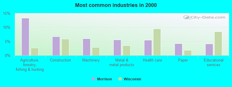
- Agriculture, forestry, fishing & hunting (13.3%)
- Construction (6.7%)
- Machinery (6.0%)
- Metal & metal products (5.6%)
- Health care (5.5%)
- Paper (4.2%)
- Educational services (4.1%)
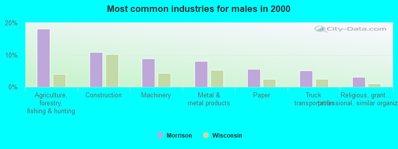
- Agriculture, forestry, fishing & hunting (18.1%)
- Construction (10.9%)
- Machinery (8.9%)
- Metal & metal products (8.1%)
- Paper (5.6%)
- Truck transportation (5.0%)
- Religious, grantmaking, civic, professional, similar organizations (3.0%)
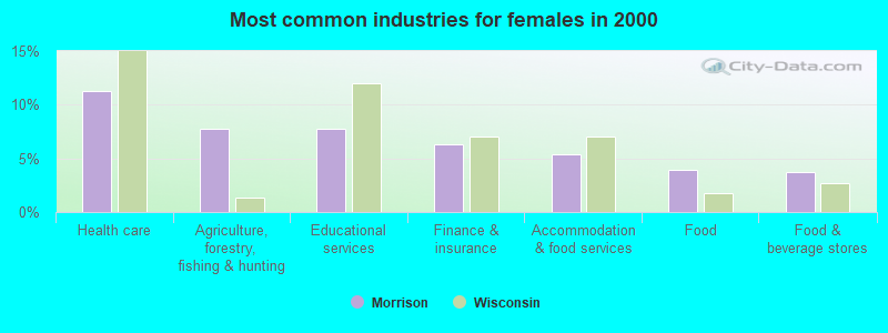
- Health care (11.2%)
- Agriculture, forestry, fishing & hunting (7.7%)
- Educational services (7.7%)
- Finance & insurance (6.3%)
- Accommodation & food services (5.4%)
- Food (4.0%)
- Food & beverage stores (3.7%)
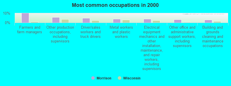
- Farmers and farm managers (10.0%)
- Other production occupations, including supervisors (5.6%)
- Driver/sales workers and truck drivers (4.9%)
- Metal workers and plastic workers (3.9%)
- Electrical equipment mechanics and other installation, maintenance, and repair workers, including supervisors (3.8%)
- Other office and administrative support workers, including supervisors (3.4%)
- Building and grounds cleaning and maintenance occupations (3.0%)
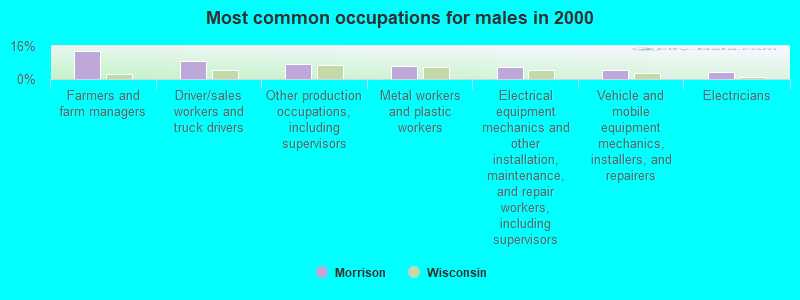
- Farmers and farm managers (13.7%)
- Driver/sales workers and truck drivers (8.7%)
- Other production occupations, including supervisors (7.5%)
- Metal workers and plastic workers (6.5%)
- Electrical equipment mechanics and other installation, maintenance, and repair workers, including supervisors (5.8%)
- Vehicle and mobile equipment mechanics, installers, and repairers (4.2%)
- Electricians (3.4%)
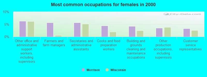
- Other office and administrative support workers, including supervisors (6.3%)
- Farmers and farm managers (5.6%)
- Secretaries and administrative assistants (5.6%)
- Cooks and food preparation workers (4.4%)
- Building and grounds cleaning and maintenance occupations (4.2%)
- Other production occupations, including supervisors (3.5%)
- Customer service representatives (3.3%)
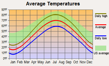
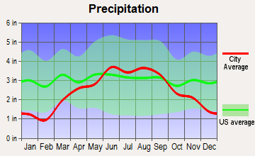
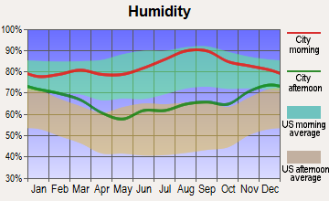
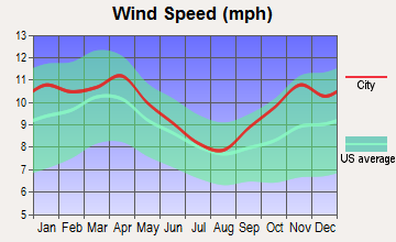
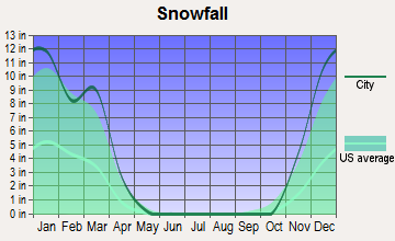
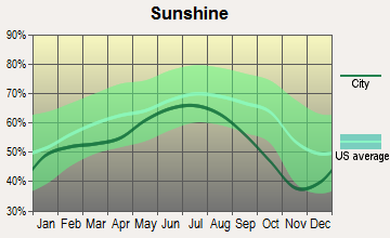
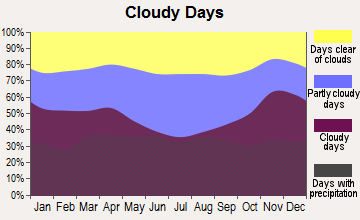
Average climate in Morrison, Wisconsin
Based on data reported by over 4,000 weather stations
(lower is better)
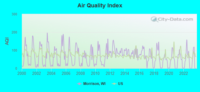
Air Quality Index (AQI) level in 2022 was 53.5. This is better than average.
| City: | 53.5 |
| U.S.: | 72.6 |
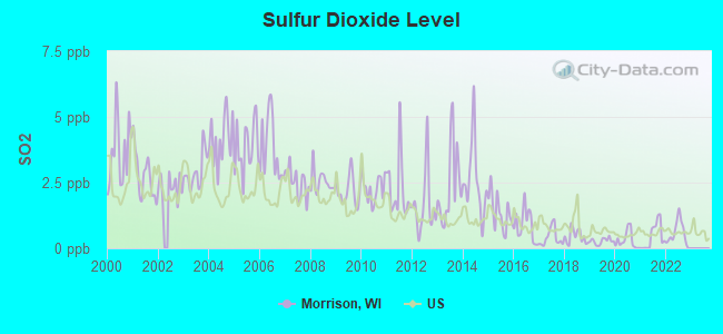
Sulfur Dioxide (SO2) [ppb] level in 2022 was 0.556. This is significantly better than average. Closest monitor was 11.7 miles away from the city center.
| City: | 0.556 |
| U.S.: | 1.515 |
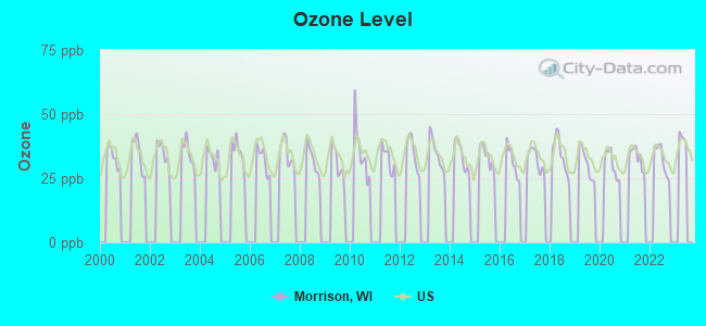
Ozone [ppb] level in 2022 was 32.3. This is about average. Closest monitor was 12.0 miles away from the city center.
| City: | 32.3 |
| U.S.: | 33.3 |
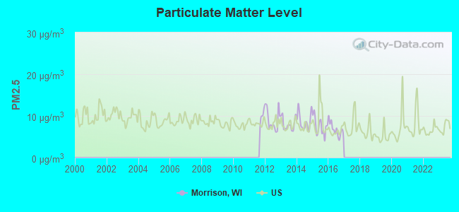
Particulate Matter (PM2.5) [µg/m3] level in 2016 was 6.75. This is better than average. Closest monitor was 16.9 miles away from the city center.
| City: | 6.75 |
| U.S.: | 8.11 |
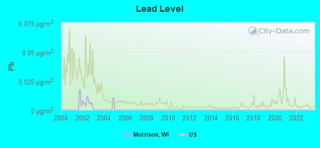
Lead (Pb) [µg/m3] level in 2002 was 0.00649. This is significantly better than average. Closest monitor was 12.6 miles away from the city center.
| City: | 0.00649 |
| U.S.: | 0.00931 |
Tornado activity:
Morrison-area historical tornado activity is slightly below Wisconsin state average. It is 2% smaller than the overall U.S. average.
On 7/5/1994, a category F4 (max. wind speeds 207-260 mph) tornado 6.4 miles away from the Morrison town center injured 2 people and caused between $500,000 and $5,000,000 in damages.
On 4/27/1984, a category F4 tornado 20.9 miles away from the town center killed one person and injured 19 people and caused between $500,000 and $5,000,000 in damages.
Earthquake activity:
Morrison-area historical earthquake activity is significantly above Wisconsin state average. It is 20% smaller than the overall U.S. average.On 5/2/2015 at 16:23:07, a magnitude 4.2 (4.2 MW, Depth: 2.8 mi, Class: Light, Intensity: IV - V) earthquake occurred 190.1 miles away from the city center
On 4/18/2008 at 09:36:59, a magnitude 5.4 (5.1 MB, 4.8 MS, 5.4 MW, 5.2 MW, Class: Moderate, Intensity: VI - VII) earthquake occurred 403.3 miles away from the city center
On 6/28/2004 at 06:10:52, a magnitude 4.2 (4.2 MW, Depth: 6.2 mi) earthquake occurred 201.1 miles away from the city center
On 6/10/1987 at 23:48:54, a magnitude 5.1 (4.9 MB, 4.4 MS, 4.6 MS, 5.1 LG) earthquake occurred 377.8 miles away from Morrison center
On 4/18/2008 at 09:36:59, a magnitude 5.2 (5.2 MW, Depth: 8.9 mi) earthquake occurred 403.3 miles away from the city center
On 2/10/2010 at 09:59:35, a magnitude 3.8 (3.8 MW, Depth: 6.2 mi, Class: Light, Intensity: II - III) earthquake occurred 162.4 miles away from the city center
Magnitude types: regional Lg-wave magnitude (LG), body-wave magnitude (MB), surface-wave magnitude (MS), moment magnitude (MW)
Natural disasters:
The number of natural disasters in Brown County (7) is smaller than the US average (15).Major Disasters (Presidential) Declared: 5
Emergencies Declared: 2
Causes of natural disasters: Floods: 4, Storms: 4, Tornadoes: 2, Drought: 1, Hurricane: 1, Other: 1 (Note: some incidents may be assigned to more than one category).
Hospitals and medical centers near Morrison:
- LEDGE VIEW NURSING CENTER (Nursing Home, about 5 miles away; DE PERE, WI)
- UNITY HOSPICE (Hospital, about 11 miles away; DE PERE, WI)
- INTERIM HLTHCARE OF NE WI (Home Health Center, about 13 miles away; GREEN BAY, WI)
- AURORA BAYCARE MED CTR Acute Care Hospitals (about 14 miles away; GREEN BAY, WI)
- RENNES HEALTH CENTER (Nursing Home, about 14 miles away; DE PERE, WI)
- BAYCARE SURG CTR EAST (Hospital, about 14 miles away; GREEN BAY, WI)
- AURORA VISITING NURSE ASSOCIATION OF WI (Home Health Center, about 14 miles away; GREEN BAY, WI)
Airports located in Morrison:
- Buchholz Farm Airport (9WI3) (Runways: 1)
Operable nuclear power plant near Morrison:
- 20 miles: Kewaunee in Carlton, WI.
Colleges/universities with over 2000 students nearest to Morrison:
- Saint Norbert College (about 13 miles; De Pere, WI; Full-time enrollment: 2,324)
- University of Wisconsin-Green Bay (about 18 miles; Green Bay, WI; FT enrollment: 5,415)
- Northeast Wisconsin Technical College (about 19 miles; Green Bay, WI; FT enrollment: 6,069)
- Lawrence University (about 23 miles; Appleton, WI; FT enrollment: 2,821)
- Fox Valley Technical College (about 26 miles; Appleton, WI; FT enrollment: 5,682)
- Lakeland College (about 31 miles; Plymouth, WI; FT enrollment: 2,395)
- University of Wisconsin-Oshkosh (about 35 miles; Oshkosh, WI; FT enrollment: 10,637)
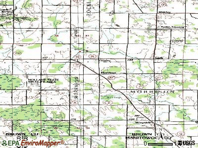
Points of interest:
Notable locations in Morrison: County Line Dairy Farm (A), Wayside Dairy Farm (B), Ness Dairy (C), Wayside Volunteer Fire Department (D), Morrison Volunteer Fire Department (E). Display/hide their locations on the map
Church in Morrison: Emmanuel Church (A). Display/hide its location on the map
Cemeteries: Zion Cemetery (1), Emmanuel Cemetery (2). Display/hide their locations on the map
Swamps: Morrison Swamp (A). Display/hide its location on the map
Park in Morrison: Way-Morr County Park (1). Display/hide its location on the map
| This town: | 2.7 people |
| Wisconsin: | 2.4 people |
| This town: | 76.5% |
| Whole state: | 64.4% |
| This town: | 5.2% |
| Whole state: | 7.3% |
Likely homosexual households (counted as self-reported same-sex unmarried-partner households)
- Lesbian couples: 0.2% of all households
- Gay men: 0.2% of all households
| This town: | 6.2% |
| Whole state: | 8.7% |
| This town: | 1.9% |
| Whole state: | 3.7% |
For population 15 years and over in Morrison:
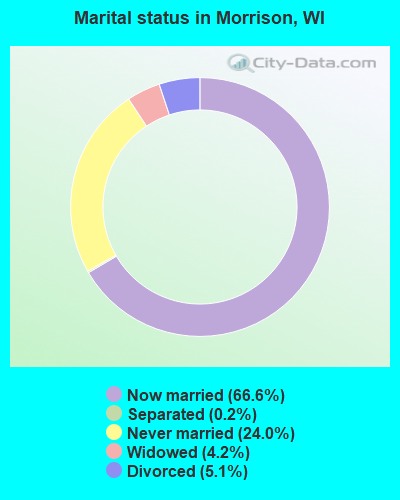
- Never married: 24.0%
- Now married: 66.6%
- Separated: 0.2%
- Widowed: 4.2%
- Divorced: 5.1%
For population 25 years and over in Morrison:
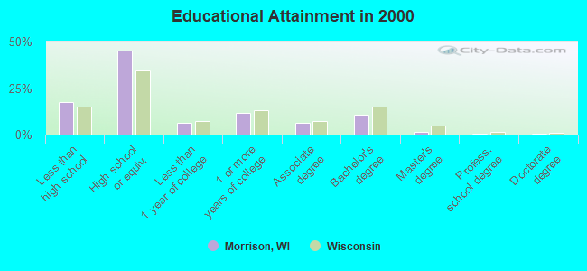
- High school or higher: 82.3%
- Bachelor's degree or higher: 13.0%
- Graduate or professional degree: 2.2%
- Unemployed: 2.5%
- Mean travel time to work (commute): 24.7 minutes
| Here: | 10.0 |
| Wisconsin average: | 11.0 |
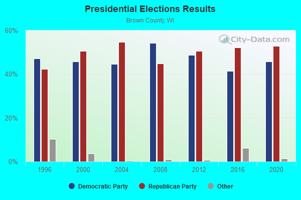
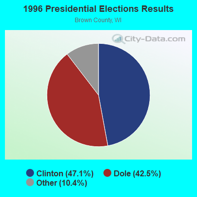
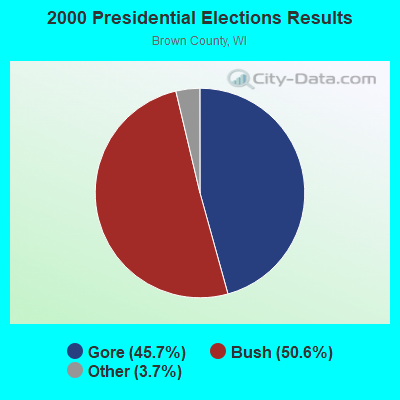
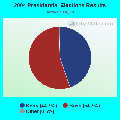
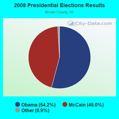
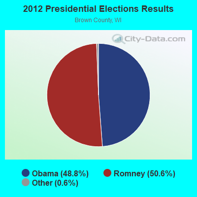
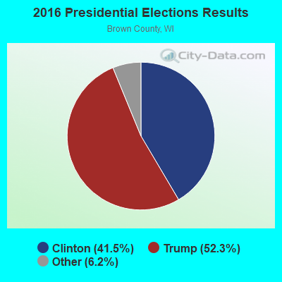

Graphs represent county-level data. Detailed 2008 Election Results
Religion statistics for Morrison, WI (based on Brown County data)
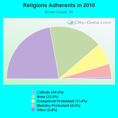
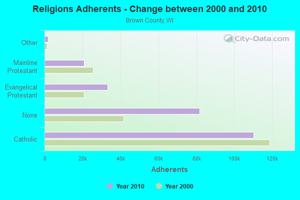
| Religion | Adherents | Congregations |
|---|---|---|
| Catholic | 110,123 | 35 |
| Evangelical Protestant | 33,156 | 79 |
| Mainline Protestant | 20,941 | 40 |
| Other | 1,913 | 12 |
| Orthodox | 100 | 1 |
| None | 81,774 | - |
Food Environment Statistics:
| Brown County: | 1.36 / 10,000 pop. |
| State: | 1.86 / 10,000 pop. |
| Brown County: | 0.12 / 10,000 pop. |
| Wisconsin: | 0.11 / 10,000 pop. |
| This county: | 0.29 / 10,000 pop. |
| State: | 0.38 / 10,000 pop. |
| This county: | 3.74 / 10,000 pop. |
| Wisconsin: | 4.12 / 10,000 pop. |
| Brown County: | 8.43 / 10,000 pop. |
| Wisconsin: | 8.64 / 10,000 pop. |
| Here: | 7.0% |
| Wisconsin: | 7.6% |
| Brown County: | 26.7% |
| State: | 27.5% |
| Brown County: | 13.1% |
| State: | 13.0% |
5.04% of this county's 2021 resident taxpayers lived in other counties in 2020 ($64,264 average adjusted gross income)
| Here: | 5.04% |
| Wisconsin average: | 6.07% |
0.02% of residents moved from foreign countries ($156 average AGI)
Brown County: 0.02% Wisconsin average: 0.00%
Top counties from which taxpayers relocated into this county between 2020 and 2021:
| from Outagamie County, WI | |
| from Oconto County, WI | |
| from Milwaukee County, WI |
4.95% of this county's 2020 resident taxpayers moved to other counties in 2021 ($63,518 average adjusted gross income)
| Here: | 4.95% |
| Wisconsin average: | 6.10% |
0.02% of residents moved to foreign countries ($127 average AGI)
Brown County: 0.02% Wisconsin average: 0.00%
Top counties to which taxpayers relocated from this county between 2020 and 2021:
| to Outagamie County, WI | |
| to Oconto County, WI | |
| to Winnebago County, WI |
Strongest AM radio stations in Morrison:
- WTAQ (1360 AM; 10 kW; GREEN BAY, WI; Owner: MIDWEST COMMUNICATIONS, INC.)
- WNAM (1280 AM; 50 kW; NEENAH-MENASHA, WI; Owner: CUMULUS LICENSING CORP.)
- WHBY (1150 AM; 25 kW; KIMBERLY, WI; Owner: WOODWARD COMMUNICATIONS, INC.)
- WNFL (1440 AM; 5 kW; GREEN BAY, WI; Owner: MIDWEST COMMUNICATIONS, INC.)
- WCUB (980 AM; 5 kW; TWO RIVERS, WI; Owner: CUB RADIO, INC.)
- WSPT (1010 AM; 50 kW; STEVENS POINT, WI)
- WTMJ (620 AM; 50 kW; MILWAUKEE, WI; Owner: JOURNAL BROADCAST CORPORATION)
- WTCM (580 AM; 35 kW; TRAVERSE CITY, MI; Owner: WTCM RADIO, INC.)
- WSAU (550 AM; 20 kW; WAUSAU, WI; Owner: WRIG, INC.)
- WISN (1130 AM; 50 kW; MILWAUKEE, WI; Owner: CAPSTAR TX LIMITED PARTNERSHIP)
- WDUZ (1400 AM; 1 kW; GREEN BAY, WI; Owner: CUMULUS LICENSING CORP.)
- WJOK (1050 AM; 1 kW; KAUKAUNA, WI; Owner: STARBOARD BROADCASTING, INC.)
- WLDR (1210 AM; daytime; 50 kW; KINGSLEY, MI; Owner: FORT BEND BROADCASTING COMPANY)
Strongest FM radio stations in Morrison:
- WHID (88.1 FM; GREEN BAY, WI; Owner: BD OF REGENTS OF THE UNIV OF WI SYS)
- WXWX (107.5 FM; BRILLION, WI; Owner: CUMULUS LICENSING CORP.)
- WOGB (103.1 FM; KAUKAUNA, WI; Owner: CUMULUS LICENSING CORP.)
- WORQ (90.1 FM; GREEN BAY, WI; Owner: LAKESHORE COMMUNICATIONS, INC.)
- WIXX (101.1 FM; GREEN BAY, WI; Owner: MIDWEST COMMUNICATIONS, INC.)
- WPNE-FM (89.3 FM; GREEN BAY, WI; Owner: WISCONSIN EDUCATIONAL COMMUNICATIONS BOARD)
- WKSZ (95.9 FM; DE PERE, WI; Owner: WOODWARD COMMUNICATIONS INC)
- WAPL-FM (105.7 FM; APPLETON, WI; Owner: WOODWARD COMMUNICATIONS, INC.)
- WPCK (104.9 FM; KAUKAUNA, WI; Owner: MIDWEST DIMENSIONS, INC.)
- WEMY (91.5 FM; GREEN BAY, WI; Owner: EVANGEL MINISTRIES, INC)
- WJLW (106.7 FM; ALLOUEZ, WI; Owner: CUMULUS LICENSING CORP)
- W270AJ (101.9 FM; GREEN BAY, WI; Owner: MIDWEST COMMUNICATIONS, INC)
- WZOR (94.7 FM; MISHICOT, WI; Owner: WOODWARD COMMUNICATIONS, INC.)
- WLTU (92.1 FM; MANITOWOC, WI; Owner: CUB RADIO, INC.)
- W215BF (90.9 FM; MANITOWOC, WI; Owner: CALVARY CHAPEL OF TWIN FALLS, INC.)
- WNCY-FM (100.3 FM; NEENAH-MENASHA, WI; Owner: MIDWEST COMMUNICATIONS, INC.)
- WLYD (99.7 FM; STURGEON BAY, WI; Owner: MIDWEST COMMUNICATIONS INC)
- WLFM (91.1 FM; APPLETON, WI; Owner: LAWRENCE UNIVERSITY OF WISCONSIN)
- WQTC-FM (102.3 FM; MANITOWOC, WI; Owner: SEEHAFER BROADCASTING CORPORATION)
- WQLH (98.5 FM; GREEN BAY, WI; Owner: CUMULUS LICENSING CORP.)
TV broadcast stations around Morrison:
- WLUK-TV (Channel 11; GREEN BAY, WI; Owner: EMMIS TELEVISION LICENSE CORPORATION)
- WFRV-TV (Channel 5; GREEN BAY, WI; Owner: CBS BROADCASTING INC.)
- WGBA (Channel 26; GREEN BAY, WI; Owner: ARIES TELECOMMUNICATION CORPORATION)
- WACY (Channel 32; APPLETON, WI; Owner: ACE TV, INC.)
- WBAY-TV (Channel 2; GREEN BAY, WI; Owner: YOUNG BROADCASTING OF GREEN BAY, INC.)
- WPNE (Channel 38; GREEN BAY, WI; Owner: WISCONSIN EDUCATIONAL COMMUNICATIONS BOARD)
- W30BU (Channel 30; GREEN BAY, WI; Owner: THREE ANGELS BROADCASTING NETWORK)
- W49CB (Channel 49; GREEN BAY, WI; Owner: TRINITY BROADCASTING NETWORK)
- WMMF-TV (Channel 68; FOND DU LAC, WI; Owner: PAPPAS TELECASTING OF WISCONSIN, A CALIFORNIA LTD PARTNRSHP)
- WIWB (Channel 14; SURING, WI; Owner: ACME TV LICENSES OF WISCONSIN, LLC)
- National Bridge Inventory (NBI) Statistics
- 13Number of bridges
- 62ft / 19.0mTotal length
- $779,000Total costs
- 7,243Total average daily traffic
- 204Total average daily truck traffic
- 7,555Total future (year 2035) average daily traffic
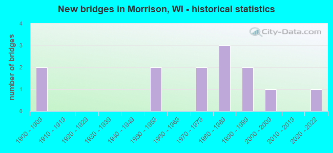
- New bridges - historical statistics
- 21900-1909
- 21950-1959
- 21970-1979
- 31980-1989
- 21990-1999
- 12000-2009
- 12020-2022
FCC Registered Antenna Towers:
2- Grant Phillips, 7987 Holly-Mor Rd. (Lat: 44.256917 Lon: -88.008778), Type: 77.7, Structure height: 55009 m, Overall height: 76.2 m, Registrant: Telecom Properties, LLC, Gphillips@towerking.Com, , Defia-nce, Phone: (419) 438-7587
- Grant Phillips, 7987 Holly-Mor Rd. (Lat: 44.256917 Lon: -88.008778), Type: 77.7, Structure height: 55009 m, Overall height: 76.2 m, Registrant: Telecom Properties, LLC, Gphillips@towerking.Com, , Defia-nce, Phone: (419) 438-7587
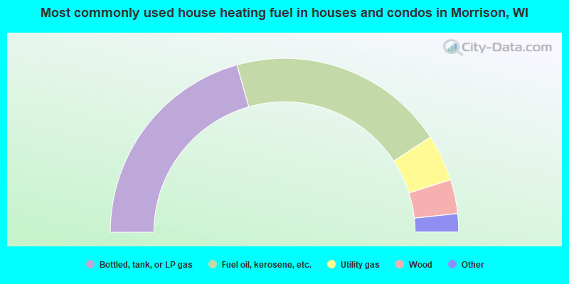
- 41.2%Bottled, tank, or LP gas
- 40.4%Fuel oil, kerosene, etc.
- 8.7%Utility gas
- 6.3%Wood
- 3.0%Electricity
- 0.4%Coal or coke
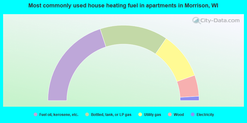
- 40.0%Fuel oil, kerosene, etc.
- 29.1%Bottled, tank, or LP gas
- 20.0%Utility gas
- 9.1%Wood
- 1.8%Electricity
Morrison compared to Wisconsin state average:
- Unemployed percentage significantly below state average.
- Black race population percentage significantly below state average.
- Hispanic race population percentage significantly below state average.
- Foreign-born population percentage significantly below state average.
- Renting percentage significantly below state average.
- Length of stay since moving in significantly above state average.
- Number of rooms per house significantly below state average.
- House age significantly below state average.
- Percentage of population with a bachelor's degree or higher below state average.