Bridge Statistics for Morrison, Wisconsin (WI)
Condition, Traffic, Stress, Structural Evaluation, Project Costs
- National Bridge Inventory (NBI) Statistics
- 13Number of bridges
- 62ft / 19.0mTotal length
- $779,000Total costs
- 7,243Total average daily traffic
- 204Total average daily truck traffic
- 7,555Total future (year 2035) average daily traffic
- National Bridge Inventory (NBI) Registered Bridges for Morrison
- No street view available for this location
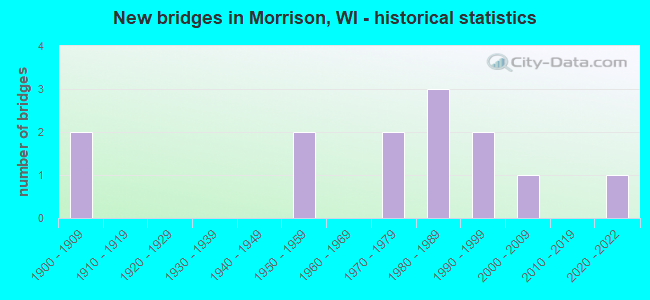
- New bridges - historical statistics
- 21900-1909
- 21950-1959
- 21970-1979
- 31980-1989
- 21990-1999
- 12000-2009
- 12020-2022

- Reconstructed bridges - Historical Statistics
- 11940-1949
- 01950-1959
- 01960-1969
- 01970-1979
- 11980-1989

- Bridge Condition - Deck
- 12.5%Excellent
- 37.5%Very good
- 25.0%Good
- 12.5%Satisfactory
- 12.5%Poor

- Bridge Condition - Superstructure
- 12.5%Excellent
- 50.0%Very good
- 25.0%Good
- 12.5%Satisfactory

- Bridge Condition - Substructure
- 12.5%Excellent
- 62.5%Very good
- 12.5%Satisfactory
- 12.5%Fair

- Bridge Condition - Channel
- 7.7%Excellent
- 76.9%Very good
- 15.4%Satisfactory

- Bridge Condition - Culverts
- 40.0%Good
- 40.0%Fair
- 20.0%Poor
Find on map >> Show street view
Structure Number: B050044, Location: 2.3M S JCT STH 96 (Lat: 44.321367, Lng: -87.887633), Route carried "on" structure: County highway , Year Built: 1957, Year Reconstructed: 1987, Status: Open, Structure Length: 1.04m (3.41ft), Average Daily Traffic: 1,163 (year 2019), Average Future Daily Traffic: 1,279 (year 2039), Design Load: HS 20, Features Intersected: DEVILS RIVER, Facility Carried by Structure: CTH NN
Minimum Vertical Clearance: 30+ m (98+ ft), Kilometerpoint: 0.000, Lanes on structure: 2, Owner: County Highway Agency, Approaching Roadway Width: 9.1m (29.9ft), Material/Design: Prestressed concrete, Design/Construction: Slab, Number Of Spans In Main Unit: 1, Length of Maximum Span: 9.9m (32.5ft), Curb-To-Curb Width: 8.6m (28.2ft), Out-to-Out Width: 8.6m (28.2ft)
Condition: Deck: Satisfactory, Superstructure: Satisfactory, Substructure: Fair, Channel: Satisfactory, Operating Rating: 70.2 metric tons, Method Used To Determine Operating Rating: Load Factor (LF), Inventory Rating: 42.1 metric tons, Method Used To Determine Inventory Rating: Load Factor (LF), Structural Evaluation: Somewhat better than minimum adequacy, Deck Geometry: Somewhat better than minimum adequacy, Waterway Adequacy: Equal to present desirable criteria, Approach Roadway Alignment: Equal to present desirable criteria, Designated Inspection Frequency: Every 24 months, Inspection Date: September 2020, Deck Structure Type: Concrete Cast-file-Place, Wearing Surface/Protective System: Wearing Surface: Bituminous
Find on map >> Show street view
Structure Number: B050112, Location: 0.4M W JCT CTH G (Lat: 44.299597, Lng: -87.958331), Route carried "on" structure: City street , Year Built: 1970, Status: Open, Structure Length: 1.02m (3.35ft), Average Daily Traffic: 117 (year 2019), Average Future Daily Traffic: 128 (year 2039), Design Load: H 20, Features Intersected: BRANCH RIVER, Facility Carried by Structure: LRD MILL RD
Minimum Vertical Clearance: 30+ m (98+ ft), Kilometerpoint: 0.000, Lanes on structure: 2, Owner: Town or Township Highway Agency, Approaching Roadway Width: 6.7m (22.0ft), Material/Design: Concrete continuous, Design/Construction: Culvert, Number Of Spans In Main Unit: 3, Length of Maximum Span: 3.4m (11.2ft)
Condition: Channel: Very good, Culverts: Good, Operating Rating: 53.9 metric tons, Method Used To Determine Operating Rating: Field evaluation and documented engineering judgment, Inventory Rating: 24.3 metric tons, Method Used To Determine Inventory Rating: Field evaluation and documented engineering judgment, Structural Evaluation: Equal to present minimum criteria, Waterway Adequacy: Equal to present desirable criteria, Approach Roadway Alignment: Equal to present desirable criteria, Designated Inspection Frequency: Every 24 months, Inspection Date: September 2020, Deck Structure Type: Concrete Cast-file-Place, Wearing Surface/Protective System: Wearing Surface: Bituminous
Find on map >> Show street view
Structure Number: B050125, Location: 0.6M N JCT CTH Z (Lat: 44.293378, Lng: -87.949447), Route carried "on" structure: County highway , Year Built: 1998, Status: Open, Structure Length: 1.83m (6.00ft), Average Daily Traffic: 1,319 (year 2019), Average Future Daily Traffic: 1,450 (year 2035), Design Load: HS 20, Features Intersected: BRANCH RIVER, Facility Carried by Structure: CTH G
Minimum Vertical Clearance: 30+ m (98+ ft), Kilometerpoint: 0.000, Lanes on structure: 2, Owner: County Highway Agency, Approaching Roadway Width: 10.7m (35.1ft), Skew: 2 degrees, Material/Design: Prestressed concrete, Design/Construction: Stringer/Multi-beam, Number Of Spans In Main Unit: 1, Length of Maximum Span: 17.0m (55.8ft), Curb-To-Curb Width: 10.4m (34.1ft), Out-to-Out Width: 11.0m (36.1ft)
Condition: Deck: Good, Superstructure: Very good, Substructure: Very good, Channel: Very good, Operating Rating: 55.5 metric tons, Method Used To Determine Operating Rating: Load Factor (LF), Inventory Rating: 35.6 metric tons, Method Used To Determine Inventory Rating: Load Factor (LF), Structural Evaluation: Equal to present desirable criteria, Deck Geometry: Equal to present minimum criteria, Waterway Adequacy: Equal to present desirable criteria, Approach Roadway Alignment: Equal to present desirable criteria, Designated Inspection Frequency: Every 48 months, Inspection Date: September 2019, Deck Structure Type: Concrete Cast-file-Place, Wearing Surface/Protective System: Wearing Surface: Monolithic Concrete, Deck Protection: Galvanized Reinforcing
Find on map >> Show street view
Structure Number: B050235, Location: 1.5M N JCT CTH W (Lat: 44.274481, Lng: -87.949097), Route carried "on" structure: County highway , Year Built: 1976, Status: Open, Structure Length: 3.12m (10.24ft), Average Daily Traffic: 913 (year 2019), Average Future Daily Traffic: 1,004 (year 2040), Design Load: HS 20, Features Intersected: BRANCH RIVER, Facility Carried by Structure: CTH G
Minimum Vertical Clearance: 30+ m (98+ ft), Kilometerpoint: 0.000, Lanes on structure: 2, Owner: County Highway Agency, Approaching Roadway Width: 11.0m (36.1ft), Skew: 3 degrees, Material/Design: Prestressed concrete, Design/Construction: Stringer/Multi-beam, Number Of Spans In Main Unit: 1, Length of Maximum Span: 29.7m (97.4ft), Curb-To-Curb Width: 10.4m (34.1ft), Out-to-Out Width: 11.0m (36.1ft)
Condition: Deck: Poor, Superstructure: Good, Substructure: Satisfactory, Channel: Very good, Operating Rating: 82.0 metric tons, Method Used To Determine Operating Rating: Load Factor (LF), Inventory Rating: 42.1 metric tons, Method Used To Determine Inventory Rating: Load Factor (LF), Structural Evaluation: Equal to present minimum criteria, Deck Geometry: Equal to present minimum criteria, Waterway Adequacy: Equal to present desirable criteria, Approach Roadway Alignment: Equal to present desirable criteria, Length Of Structure Improvement: 3.57m (11.71ft), Designated Inspection Frequency: Every 24 months, Inspection Date: September 2021, Bridge Improvement Cost: $380,000, Roadway Improvement Cost: $38,000, Total Project Cost: $570,000 ( Estimate for 2021), Deck Structure Type: Concrete Cast-file-Place, Wearing Surface/Protective System: Wearing Surface: Monolithic Concrete
Find on map >> Show street view
Structure Number: B050265, Location: 2.3M E JCT CTH W (Lat: 44.313758, Lng: -87.961856), Route carried "on" structure: State highway 96, Year Built: 1983, Status: Open, Structure Length: 1.16m (3.81ft), Average Daily Traffic: 1,500 (year 2020), Truck Traffic: 13%, Average Future Daily Traffic: 1,240 (year 2039), Design Load: HS 20, Features Intersected: BRANCH RIVER
Minimum Vertical Clearance: 30+ m (98+ ft), Kilometerpoint: 0.000, Lanes on structure: 2, Owner: State Highway Agency, Approaching Roadway Width: 10.4m (34.1ft), Material/Design: Concrete, Design/Construction: Culvert, Number Of Spans In Main Unit: 3, Length of Maximum Span: 3.7m (12.1ft)
Condition: Channel: Very good, Culverts: Good, Operating Rating: 53.9 metric tons, Method Used To Determine Operating Rating: Field evaluation and documented engineering judgment, Inventory Rating: 32.4 metric tons, Method Used To Determine Inventory Rating: Field evaluation and documented engineering judgment, Structural Evaluation: Better than present minimum criteria, Waterway Adequacy: Equal to present desirable criteria, Approach Roadway Alignment: Equal to present desirable criteria, Designated Inspection Frequency: Every 48 months, Inspection Date: August 2020, Deck Structure Type: Concrete Cast-file-Place, Wearing Surface/Protective System: Wearing Surface: Bituminous
Find on map >> Show street view
Structure Number: B050273, Location: 0.6M E JCT CTH G (Lat: 44.240414, Lng: -87.910225), Route carried "on" structure: City street , Year Built: 1989, Status: Open, Structure Length: 1.79m (5.87ft), Average Daily Traffic: 119 (year 2019), Average Future Daily Traffic: 130 (year 2039), Design Load: HS 20, Features Intersected: BRANCH RIVER, Facility Carried by Structure: LRD COUNTY LINE RD
Minimum Vertical Clearance: 30+ m (98+ ft), Kilometerpoint: 0.000, Lanes on structure: 2, Owner: Town or Township Highway Agency, Approaching Roadway Width: 7.9m (25.9ft), Skew: 3 degrees, Material/Design: Concrete continuous, Design/Construction: Slab, Number Of Spans In Main Unit: 2, Length of Maximum Span: 8.2m (26.9ft), Curb-To-Curb Width: 7.3m (24.0ft), Out-to-Out Width: 7.9m (25.9ft)
Condition: Deck: Very good, Superstructure: Very good, Substructure: Very good, Channel: Very good, Operating Rating: 67.0 metric tons, Method Used To Determine Operating Rating: Load Factor (LF), Inventory Rating: 40.5 metric tons, Method Used To Determine Inventory Rating: Load Factor (LF), Structural Evaluation: Equal to present desirable criteria, Deck Geometry: Somewhat better than minimum adequacy, Waterway Adequacy: Meets minimum limits, Approach Roadway Alignment: Equal to present desirable criteria, Designated Inspection Frequency: Every 48 months, Inspection Date: September 2020, Deck Structure Type: Concrete Cast-file-Place, Wearing Surface/Protective System: Wearing Surface: Monolithic Concrete, Deck Protection: Epoxy Coated Reinforcing
Find on map >> Show street view
Structure Number: B050277, Location: 2.3M S JCT STH 96 (Lat: 44.322111, Lng: -87.908386), Route carried "on" structure: City street , Year Built: 1985, Status: Open, Structure Length: 1.15m (3.77ft), Average Daily Traffic: 115 (year 2019), Average Future Daily Traffic: 126 (year 2039), Design Load: H 20, Features Intersected: DEVILS RIVER, Facility Carried by Structure: LRD FAIRVIEW RD
Minimum Vertical Clearance: 30+ m (98+ ft), Kilometerpoint: 0.000, Lanes on structure: 2, Owner: Town or Township Highway Agency, Approaching Roadway Width: 7.3m (24.0ft), Material/Design: Concrete, Design/Construction: Slab, Number Of Spans In Main Unit: 1, Length of Maximum Span: 11.0m (36.1ft), Curb-To-Curb Width: 7.3m (24.0ft), Out-to-Out Width: 7.9m (25.9ft)
Condition: Deck: Good, Superstructure: Good, Substructure: Very good, Channel: Very good, Operating Rating: 49.0 metric tons, Method Used To Determine Operating Rating: Load Factor (LF), Inventory Rating: 29.2 metric tons, Method Used To Determine Inventory Rating: Load Factor (LF), Structural Evaluation: Better than present minimum criteria, Deck Geometry: Somewhat better than minimum adequacy, Waterway Adequacy: Equal to present desirable criteria, Approach Roadway Alignment: Equal to present desirable criteria, Designated Inspection Frequency: Every 24 months, Inspection Date: September 2020, Deck Structure Type: Concrete Cast-file-Place, Wearing Surface/Protective System: Wearing Surface: Bituminous
Find on map >> Show street view
Structure Number: B050324, Location: 1.5M E JCT CTH W (Lat: 44.254836, Lng: -87.919722), Route carried "on" structure: City street , Year Built: 1997, Status: Open, Structure Length: 1.88m (6.17ft), Average Daily Traffic: 135 (year 2019), Average Future Daily Traffic: 148 (year 2039), Design Load: HS 20, Features Intersected: BRANCH RIVER, Facility Carried by Structure: LRD WAYSIDE RD
Minimum Vertical Clearance: 30+ m (98+ ft), Kilometerpoint: 0.000, Lanes on structure: 2, Owner: Town or Township Highway Agency, Approaching Roadway Width: 8.5m (27.9ft), Skew: 2 degrees, Material/Design: Prestressed concrete, Design/Construction: Stringer/Multi-beam, Number Of Spans In Main Unit: 1, Length of Maximum Span: 17.5m (57.4ft), Curb-To-Curb Width: 7.8m (25.6ft), Out-to-Out Width: 8.4m (27.6ft)
Condition: Deck: Very good, Superstructure: Very good, Substructure: Very good, Channel: Very good, Operating Rating: 68.6 metric tons, Method Used To Determine Operating Rating: Load Factor (LF), Inventory Rating: 42.1 metric tons, Method Used To Determine Inventory Rating: Load Factor (LF), Structural Evaluation: Equal to present desirable criteria, Deck Geometry: Somewhat better than minimum adequacy, Waterway Adequacy: Equal to present desirable criteria, Approach Roadway Alignment: Equal to present desirable criteria, Designated Inspection Frequency: Every 48 months, Inspection Date: September 2020, Deck Structure Type: Concrete Cast-file-Place, Wearing Surface/Protective System: Wearing Surface: Monolithic Concrete, Deck Protection: Epoxy Coated Reinforcing
Find on map >> Show street view
Structure Number: B050361, Location: 2.3M S JCT CTH Z (Lat: 44.251881, Lng: -87.917697), Route carried "on" structure: City street , Year Built: 2004, Status: Open, Structure Length: 1.45m (4.76ft), Average Daily Traffic: 105 (year 2019), Truck Traffic: 8%, Average Future Daily Traffic: 115 (year 2039), Design Load: HS 20, Features Intersected: BRANCH RIVER, Facility Carried by Structure: LRD RIVER RD
Minimum Vertical Clearance: 30+ m (98+ ft), Kilometerpoint: 0.000, Lanes on structure: 2, Owner: County Highway Agency, Maintenance Responsibility: Town or Township Highway Agency, Approaching Roadway Width: 7.9m (25.9ft), Material/Design: Concrete, Design/Construction: Slab, Number Of Spans In Main Unit: 1, Length of Maximum Span: 13.7m (44.9ft), Curb-To-Curb Width: 7.3m (24.0ft), Out-to-Out Width: 7.9m (25.9ft)
Condition: Deck: Very good, Superstructure: Very good, Substructure: Very good, Channel: Very good, Operating Rating: 58.8 metric tons, Method Used To Determine Operating Rating: Load Factor (LF), Inventory Rating: 35.6 metric tons, Method Used To Determine Inventory Rating: Load Factor (LF), Structural Evaluation: Equal to present desirable criteria, Deck Geometry: Somewhat better than minimum adequacy, Waterway Adequacy: Equal to present desirable criteria, Approach Roadway Alignment: Equal to present desirable criteria, Designated Inspection Frequency: Every 48 months, Inspection Date: September 2020, Deck Structure Type: Concrete Cast-file-Place, Wearing Surface/Protective System: Wearing Surface: Monolithic Concrete, Deck Protection: Epoxy Coated Reinforcing
Find on map >> Show street view
Structure Number: B050425, Location: 2.3M S JCT STH 96 (Lat: 44.325944, Lng: -87.938583), Route carried "on" structure: City street , Year Built: 2020, Status: Open, Structure Length: 0.93m (3.05ft), Average Daily Traffic: 20 (year 2018), Truck Traffic: 5%, Average Future Daily Traffic: 25 (year 2038), Design Load: HL 93, Features Intersected: DEVILS RIVER, Facility Carried by Structure: LRD PARK VIEW RD
Minimum Vertical Clearance: 30+ m (98+ ft), Kilometerpoint: 0.000, Lanes on structure: 2, Owner: Town or Township Highway Agency, Approaching Roadway Width: 7.3m (24.0ft), Skew: 2 degrees, Material/Design: Concrete, Design/Construction: Slab, Number Of Spans In Main Unit: 1, Length of Maximum Span: 8.5m (27.9ft), Curb-To-Curb Width: 7.3m (24.0ft), Out-to-Out Width: 8.1m (26.6ft)
Condition: Deck: Excellent, Superstructure: Excellent, Substructure: Excellent, Channel: Excellent, Operating Rating: 48.0 metric tons, Method Used To Determine Operating Rating: Load and Resistance Factor Rating (LRFR) rating reported by rating factor(RF) method using HL-93 loadings, Inventory Rating: 36.6 metric tons, Method Used To Determine Inventory Rating: Load and Resistance Factor Rating (LRFR) rating reported by rating factor(RF) method using HL-93 loadings, Structural Evaluation: Superior to present desirable criteria, Deck Geometry: Equal to present minimum criteria, Waterway Adequacy: Superior to present desirable criteria, Approach Roadway Alignment: Equal to present desirable criteria, Designated Inspection Frequency: Every 24 months, Inspection Date: August 2020, Deck Structure Type: Concrete Cast-file-Place, Wearing Surface/Protective System: Wearing Surface: Monolithic Concrete
Find on map >> Show street view
Structure Number: P050042, Location: 1.9M N JCT CTH W (Lat: 44.278500, Lng: -87.949139), Route carried "on" structure: County highway , Year Built: 1957, Status: Open, Structure Length: 1.20m (3.94ft), Average Daily Traffic: 913 (year 2019), Average Future Daily Traffic: 1,004 (year 2040), Design Load: H 20, Features Intersected: BRANCH RIVER, Facility Carried by Structure: CTH G
Minimum Vertical Clearance: 30+ m (98+ ft), Kilometerpoint: 0.000, Lanes on structure: 2, Owner: County Highway Agency, Approaching Roadway Width: 11.0m (36.1ft), Material/Design: Steel, Design/Construction: Culvert, Number Of Spans In Main Unit: 2, Length of Maximum Span: 5.5m (18.0ft)
Condition: Channel: Very good, Culverts: Fair, Operating Rating: 53.9 metric tons, Method Used To Determine Operating Rating: Field evaluation and documented engineering judgment, Inventory Rating: 24.3 metric tons, Method Used To Determine Inventory Rating: Field evaluation and documented engineering judgment, Structural Evaluation: Somewhat better than minimum adequacy, Waterway Adequacy: Equal to present desirable criteria, Approach Roadway Alignment: Equal to present desirable criteria, Designated Inspection Frequency: Every 24 months, Inspection Date: September 2021, Deck Structure Type: Concrete Cast-file-Place, Wearing Surface/Protective System: Wearing Surface: Bituminous
Find on map >> Show street view
Structure Number: P050141, Location: 0.1M E JCT CTH G (Lat: 44.284753, Lng: -87.948053), Route carried "on" structure: County highway , Year Built: 1900, Year Reconstructed: 1949, Status: Open, Structure Length: 1.02m (3.35ft), Average Daily Traffic: 730 (year 2019), Average Future Daily Traffic: 803 (year 2040), Design Load: H 20, Features Intersected: BRANCH RIVER, Facility Carried by Structure: CTH Z
Minimum Vertical Clearance: 30+ m (98+ ft), Kilometerpoint: 0.000, Lanes on structure: 2, Owner: County Highway Agency, Approaching Roadway Width: 9.1m (29.9ft), Material/Design: Steel, Design/Construction: Culvert, Number Of Spans In Main Unit: 2, Length of Maximum Span: 4.6m (15.1ft)
Condition: Channel: Very good, Culverts: Poor, Operating Rating: 53.9 metric tons, Method Used To Determine Operating Rating: Field evaluation and documented engineering judgment, Inventory Rating: 24.3 metric tons, Method Used To Determine Inventory Rating: Field evaluation and documented engineering judgment, Structural Evaluation: Meets minimum limits, Waterway Adequacy: Equal to present desirable criteria, Approach Roadway Alignment: Equal to present desirable criteria, Length Of Structure Improvement: 1.46m (4.79ft), Designated Inspection Frequency: Every 12 months, Inspection Date: September 2021, Bridge Improvement Cost: $139,000, Roadway Improvement Cost: $13,000, Total Project Cost: $209,000 ( Estimate for 2021), Deck Structure Type: Concrete Cast-file-Place, Wearing Surface/Protective System: Wearing Surface: Bituminous
Find on map >> Show street view
Structure Number: P050142, Location: 0.6M E JCT CTH G (Lat: 44.269767, Lng: -87.936867), Route carried "on" structure: City street , Year Built: 1909, Status: Open, Structure Length: 1.37m (4.49ft), Average Daily Traffic: 94 (year 2019), Average Future Daily Traffic: 103 (year 2039), Design Load: H 15, Features Intersected: BRANCH RIVER, Facility Carried by Structure: LRD HILL RD
Minimum Vertical Clearance: 30+ m (98+ ft), Kilometerpoint: 0.000, Lanes on structure: 1, Owner: Town or Township Highway Agency, Approaching Roadway Width: 4.9m (16.1ft), Skew: 3 degrees, Material/Design: Steel, Design/Construction: Culvert, Number Of Spans In Main Unit: 2, Length of Maximum Span: 6.9m (22.6ft)
Condition: Channel: Satisfactory, Culverts: Fair, Operating Rating: 53.9 metric tons, Method Used To Determine Operating Rating: Field evaluation and documented engineering judgment, Inventory Rating: 24.3 metric tons, Method Used To Determine Inventory Rating: Field evaluation and documented engineering judgment, Structural Evaluation: Somewhat better than minimum adequacy, Waterway Adequacy: Meets minimum limits, Approach Roadway Alignment: Equal to present desirable criteria, Designated Inspection Frequency: Every 24 months, Inspection Date: September 2020, Deck Structure Type: Corrugated Steel, Wearing Surface/Protective System: Wearing Surface: Bituminous