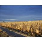
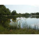
Morrill, Nebraska
Submit your own pictures of this village and show them to the world
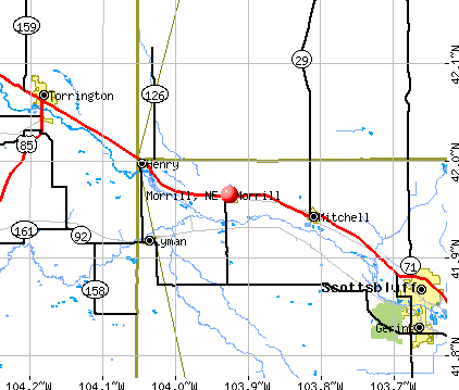
- OSM Map
- General Map
- Google Map
- MSN Map
Population change since 2000: -3.9%
 |
| Males: 406 | |
| Females: 514 |
| Median resident age: | 46.3 years |
| Nebraska median age: | 37.4 years |
Zip codes: 69358.
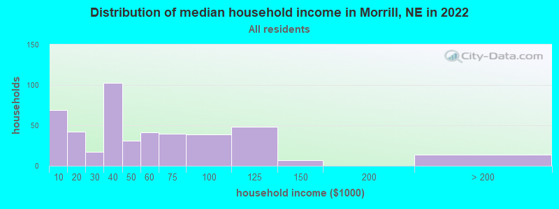
| Morrill: | $39,664 |
| NE: | $69,597 |
Estimated per capita income in 2022: $31,584 (it was $20,191 in 2000)
Morrill village income, earnings, and wages data
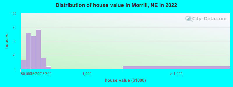
Estimated median house or condo value in 2022: $150,676 (it was $52,000 in 2000)
| Morrill: | $150,676 |
| NE: | $232,400 |
Mean prices in 2022: all housing units: $258,645; detached houses: $269,740; mobile homes: $71,615
Detailed information about poverty and poor residents in Morrill, NE
Compare current foreclosures near Morrill, NE:
| Photo | Address | Area | Beds / Baths | Price | Details |
|---|---|---|---|---|---|

|
#1
Monroe Ave
Morrill, NE 69358
|
2,093 sq. feet
|
2 baths 3 beds |
show details | |

|
#2
Dineen Ave
Scottsbluff, NE 69361
|
1,112 sq. feet
|
1 baths 2 beds |
show details | |

|
#3
12th St
Gering, NE 69341
|
1,180 sq. feet
|
1 baths 2 beds |
show details | |

|
#4
9th Ave
Scottsbluff, NE 69361
|
1,584 sq. feet
|
1 baths 2 beds |
show details | |

|
#5
Avenue F
Scottsbluff, NE 69361
|
3,060 sq. feet
|
1 baths 1 beds |
show details | |

|
#6
E C St
Torrington, WY 82240
|
980 sq. feet
|
1 baths 2 beds |
show details | |

|
#7
Buffalo Rd
Gering, NE 69341
|
1,792 sq. feet
|
1 baths 2 beds |
show details | |

|
#8
Ave D
Scottsbluff, NE 69361
|
1,922 sq. feet
|
2 baths 2 beds |
show details | |

|
#9
18th Ave
Mitchell, NE 69357
|
910 sq. feet
|
1 baths 2 beds |
show details | |

|
#10
W B St
Torrington, WY 82240
|
1,656 sq. feet
|
2 baths 2 beds |
show details |
| Photo | Address | Area | Beds / Baths | Price | Details |
|---|---|---|---|---|---|

|
#11
11th Ave
Scottsbluff, NE 69361
|
1,020 sq. feet
|
1 baths 3 beds |
show details | |

|
#12
Pacific Blvd
Gering, NE 69341
|
1,222 sq. feet
|
1 baths 2 beds |
show details | |

|
#13
County Road F
Mitchell, NE 69357
|
2,452 sq. feet
|
2 baths 4 beds |
show details | |

|
#14
Monument Valley Dr
Gering, NE 69341
|
4,616 sq. feet
|
2 baths 4 beds |
show details | |

|
#15
E B St
Torrington, WY 82240
|
1,330 sq. feet
|
1 baths 3 beds |
show details | |

|
#16
County Road T
Gering, NE 69341
|
3,112 sq. feet
|
2 baths 4 beds |
show details | |

|
#17
W 35th St
Scottsbluff, NE 69361
|
2,823 sq. feet
|
3 baths 3 beds |
show details | |

|
#18
Bonanza St
Gering, NE 69341
|
1,440 sq. feet
|
1 baths 3 beds |
show details | |

|
#19
12th Ave
Mitchell, NE 69357
|
2,053 sq. feet
|
1 baths 3 beds |
show details | |

|
#20
Avenue G
Scottsbluff, NE 69361
|
1,267 sq. feet
|
1 baths 2 beds |
show details |
| Photo | Address | Area | Beds / Baths | Price | Details |
|---|---|---|---|---|---|

|
#21
W 29th St
Scottsbluff, NE 69361
|
1,545 sq. feet
|
1 baths 2 beds |
show details | |

|
#22
Bonanza St
Gering, NE 69341
|
1,008 sq. feet
|
1 baths 3 beds |
show details | |

|
#23
12th Ave
Scottsbluff, NE 69361
|
- sq. feet
|
- baths - beds |
show details | |

|
#24
12th St Apt 1b
Gering, NE 69341
|
- sq. feet
|
- baths - beds |
show details | |

|
#25
Broadway St
Mitchell, NE 69357
|
- sq. feet
|
- baths - beds |
show details | |

|
#26
1/2 P St
Gering, NE 69341
|
- sq. feet
|
- baths - beds |
show details | |

|
#27
17th St
Gering, NE 69341
|
- sq. feet
|
- baths - beds |
show details | |

|
#28
N St
Gering, NE 69341
|
- sq. feet
|
- baths - beds |
show details | |

|
#29
W 20th St, Trlr 5
Scottsbluff, NE 69361
|
- sq. feet
|
- baths - beds |
show details | |

|
#30
W B St
Torrington, WY 82240
|
- sq. feet
|
- baths - beds |
show details |
| Photo | Address | Area | Beds / Baths | Price | Details |
|---|---|---|---|---|---|

|
#31
12th Ave # G
Scottsbluff, NE 69361
|
- sq. feet
|
- baths - beds |
show details | |

|
#32
Broadway # 606
Scottsbluff, NE 69361
|
- sq. feet
|
- baths - beds |
show details | |

|
#33
Avenue O
Scottsbluff, NE 69361
|
- sq. feet
|
- baths - beds |
show details | |

|
#34
1st Ave Apt 3
Scottsbluff, NE 69361
|
- sq. feet
|
- baths - beds |
show details | |

|
#35
5th Ave Apt 1
Scottsbluff, NE 69361
|
- sq. feet
|
- baths - beds |
show details | |

|
#36
W 20th St
Scottsbluff, NE 69361
|
- sq. feet
|
- baths - beds |
show details | |

|
#37
W 25th St
Scottsbluff, NE 69361
|
- sq. feet
|
- baths - beds |
show details | |

|
#38
Avenue B
Scottsbluff, NE 69361
|
- sq. feet
|
- baths - beds |
show details | |

|
#39
Avenue M
Scottsbluff, NE 69361
|
- sq. feet
|
- baths - beds |
show details | |

|
#40
Char Ave
Scottsbluff, NE 69361
|
- sq. feet
|
- baths - beds |
show details |
| Photo | Address | Area | Beds / Baths | Price | Details |
|---|---|---|---|---|---|

|
#41
Warner St
Mitchell, NE 69357
|
- sq. feet
|
- baths - beds |
show details | |

|
#42
5th St
Gering, NE 69341
|
- sq. feet
|
- baths - beds |
show details | |

|
Check over 1 million property listings on Foreclosure.com!
|
browse all offers | |||


- 56873.2%White alone
- 16321.0%Hispanic
- 354.5%Two or more races
- 111.4%American Indian alone
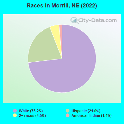
Races in Morrill detailed stats: ancestries, foreign born residents, place of birth
According to our research of Nebraska and other state lists, there were 8 registered sex offenders living in Morrill, Nebraska as of May 11, 2024.
The ratio of all residents to sex offenders in Morrill is 114 to 1.
Type |
2019 |
2020 |
2021 |
2022 |
|---|---|---|---|---|
| Murders (per 100,000) | 0 (0.0) | 0 (0.0) | 0 (0.0) | 0 (0.0) |
| Rapes (per 100,000) | 0 (0.0) | 0 (0.0) | 0 (0.0) | 0 (0.0) |
| Robberies (per 100,000) | 0 (0.0) | 0 (0.0) | 0 (0.0) | 0 (0.0) |
| Assaults (per 100,000) | 0 (0.0) | 0 (0.0) | 0 (0.0) | 1 (108.5) |
| Burglaries (per 100,000) | 2 (224.2) | 1 (113.0) | 1 (115.1) | 0 (0.0) |
| Thefts (per 100,000) | 6 (672.6) | 6 (678.0) | 9 (1,036) | 6 (650.8) |
| Auto thefts (per 100,000) | 1 (112.1) | 1 (113.0) | 0 (0.0) | 0 (0.0) |
| Arson (per 100,000) | 0 (0.0) | 0 (0.0) | 0 (0.0) | 0 (0.0) |
| City-Data.com crime index | 51.6 | 44.1 | 49.5 | 47.7 |
The City-Data.com crime index weighs serious crimes and violent crimes more heavily. Higher means more crime, U.S. average is 246.1. It adjusts for the number of visitors and daily workers commuting into cities.
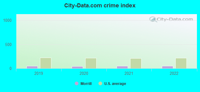
Crime rate in Morrill detailed stats: murders, rapes, robberies, assaults, burglaries, thefts, arson
Full-time law enforcement employees in 2021, including police officers: 2 (2 officers - 2 male; 0 female).
| Officers per 1,000 residents here: | 2.30 |
| US average: | 2.38 |
 Recent articles from our blog. Our writers, many of them Ph.D. graduates or candidates, create easy-to-read articles on a wide variety of topics.


Latest news from Morrill, NE collected exclusively by city-data.com from local newspapers, TV, and radio stations
Ancestries: German (30.7%), English (12.2%), Irish (6.8%), American (3.7%), Dutch (2.7%).
Current Local Time: MST time zone
Incorporated on 04/11/1907
Elevation: 3988 feet
Land area: 0.59 square miles.
Population density: 1,548 people per square mile (low).
18 residents are foreign born (1.7% Latin America, 0.6% Asia).
| This village: | 2.3% |
| Nebraska: | 7.5% |
Median real estate property taxes paid for housing units with mortgages in 2022: $2,088 (1.4%)
Median real estate property taxes paid for housing units with no mortgage in 2022: $1,779 (1.2%)
Nearest city with pop. 50,000+: Cheyenne, WY  (72.6 miles , pop. 53,011).
Nearest city with pop. 200,000+: West Adams, CO (154.9 miles , pop. 259,628).
Nearest city with pop. 1,000,000+: Phoenix, AZ (733.6 miles , pop. 1,321,045).
Nearest cities:
), ), Latitude: 41.96 N, Longitude: 103.93 W
Area code: 308

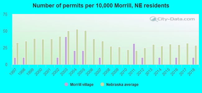
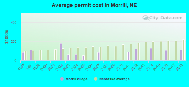
Single-family new house construction building permits:
- 2018: 1 building, cost: $110,000
- 2016: 1 building, cost: $108,000
- 2014: 1 building, cost: $129,000
- 2012: 1 building, cost: $120,000
- 2011: 3 buildings, average cost: $89,300
- 2007: 1 building, cost: $86,000
- 2005: 2 buildings, average cost: $52,500
- 2004: 2 buildings, average cost: $62,500
- 2003: 4 buildings, average cost: $60,000
- 2002: 1 building, cost: $180,000
- 1998: 1 building, cost: $110,000
- 1997: 1 building, cost: $85,400
| Here: | 2.6% |
| Nebraska: | 2.2% |
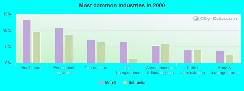
- Health care (13.3%)
- Educational services (10.8%)
- Construction (7.1%)
- Rail transportation (6.4%)
- Accommodation & food services (5.3%)
- Public administration (4.0%)
- Food & beverage stores (3.8%)
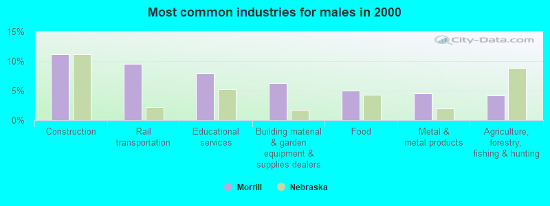
- Construction (11.2%)
- Rail transportation (9.5%)
- Educational services (7.9%)
- Building material & garden equipment & supplies dealers (6.2%)
- Food (5.0%)
- Metal & metal products (4.6%)
- Agriculture, forestry, fishing & hunting (4.1%)
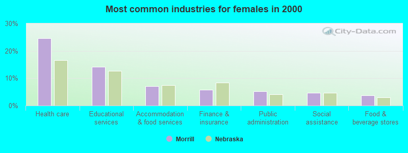
- Health care (24.6%)
- Educational services (14.2%)
- Accommodation & food services (7.1%)
- Finance & insurance (5.7%)
- Public administration (5.2%)
- Social assistance (4.7%)
- Food & beverage stores (3.8%)
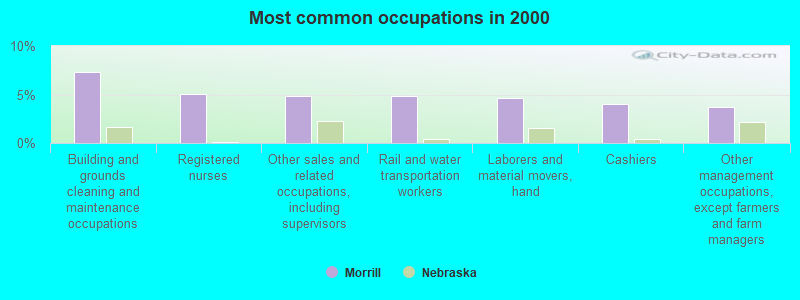
- Building and grounds cleaning and maintenance occupations (7.3%)
- Registered nurses (5.1%)
- Other sales and related occupations, including supervisors (4.9%)
- Rail and water transportation workers (4.9%)
- Laborers and material movers, hand (4.6%)
- Cashiers (4.0%)
- Other management occupations, except farmers and farm managers (3.8%)
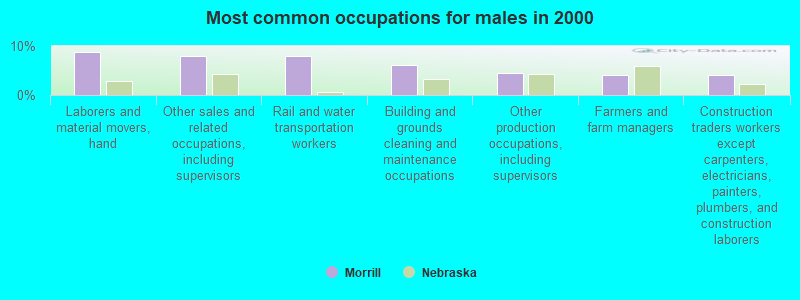
- Laborers and material movers, hand (8.7%)
- Other sales and related occupations, including supervisors (7.9%)
- Rail and water transportation workers (7.9%)
- Building and grounds cleaning and maintenance occupations (6.2%)
- Other production occupations, including supervisors (4.6%)
- Farmers and farm managers (4.1%)
- Construction traders workers except carpenters, electricians, painters, plumbers, and construction laborers (4.1%)
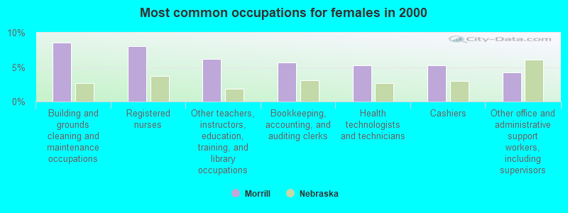
- Building and grounds cleaning and maintenance occupations (8.5%)
- Registered nurses (8.1%)
- Other teachers, instructors, education, training, and library occupations (6.2%)
- Bookkeeping, accounting, and auditing clerks (5.7%)
- Health technologists and technicians (5.2%)
- Cashiers (5.2%)
- Other office and administrative support workers, including supervisors (4.3%)
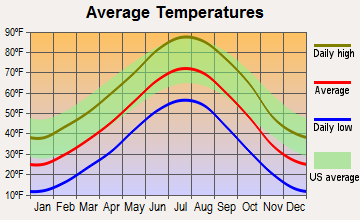
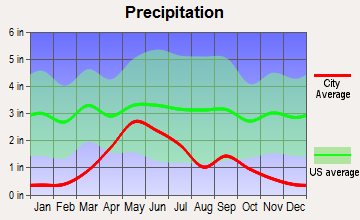
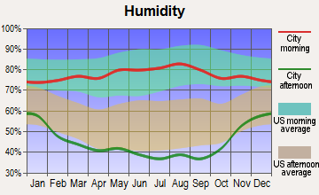
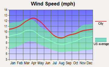
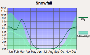
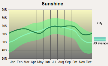
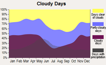
Average climate in Morrill, Nebraska
Based on data reported by over 4,000 weather stations
(lower is better)
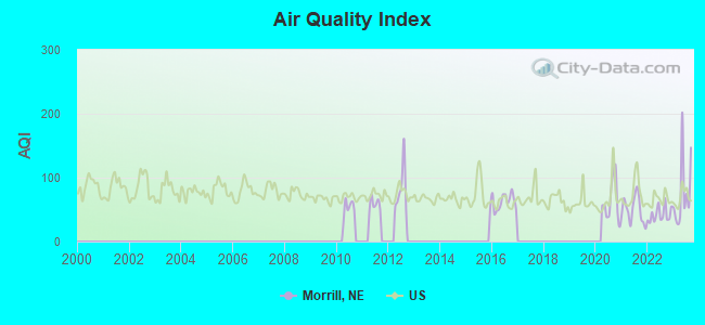
Air Quality Index (AQI) level in 2023 was 75.8. This is about average.
| City: | 75.8 |
| U.S.: | 72.6 |
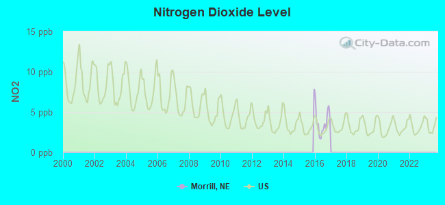
Nitrogen Dioxide (NO2) [ppb] level in 2016 was 3.67. This is better than average. Closest monitor was 14.0 miles away from the city center.
| City: | 3.67 |
| U.S.: | 5.11 |
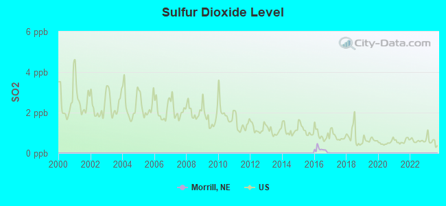
Sulfur Dioxide (SO2) [ppb] level in 2016 was 0.162. This is significantly better than average. Closest monitor was 14.0 miles away from the city center.
| City: | 0.162 |
| U.S.: | 1.515 |
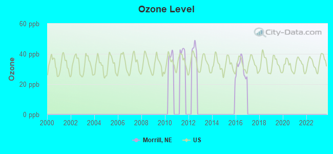
Ozone [ppb] level in 2016 was 31.0. This is about average. Closest monitor was 14.0 miles away from the city center.
| City: | 31.0 |
| U.S.: | 33.3 |
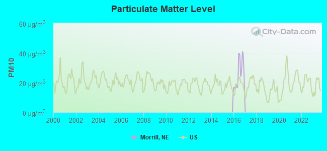
Particulate Matter (PM10) [µg/m3] level in 2016 was 25.9. This is worse than average. Closest monitor was 14.0 miles away from the city center.
| City: | 25.9 |
| U.S.: | 19.2 |
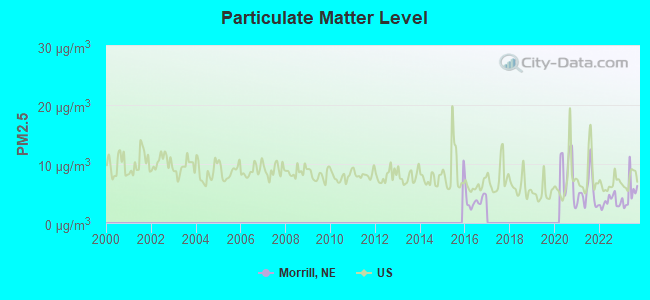
Particulate Matter (PM2.5) [µg/m3] level in 2023 was 5.03. This is significantly better than average. Closest monitor was 14.0 miles away from the city center.
| City: | 5.03 |
| U.S.: | 8.11 |
Tornado activity:
Morrill-area historical tornado activity is significantly below Nebraska state average. It is 22% smaller than the overall U.S. average.
On 6/27/1955, a category F4 (max. wind speeds 207-260 mph) tornado 6.9 miles away from the Morrill village center killed 2 people and injured 29 people and caused between $50,000 and $500,000 in damages.
On 6/26/1955, a category F3 (max. wind speeds 158-206 mph) tornado 20.3 miles away from the village center .
Earthquake activity:
Morrill-area historical earthquake activity is significantly above Nebraska state average. It is 517% greater than the overall U.S. average.On 8/18/1959 at 06:37:13, a magnitude 7.7 (7.7 UK, Class: Major, Intensity: VIII - XII) earthquake occurred 383.5 miles away from Morrill center, causing $26,000,000 total damage
On 10/18/1984 at 15:30:23, a magnitude 5.5 (5.4 MB, 5.1 MS, 5.5 ML, Class: Moderate, Intensity: VI - VII) earthquake occurred 89.3 miles away from the city center
On 10/28/1983 at 14:06:06, a magnitude 7.3 (6.2 MB, 7.3 MS, 7.0 MW) earthquake occurred 520.0 miles away from the city center, causing 2 deaths (2 shaking deaths) and 3 injuries, causing $15,000,000 total damage
On 9/8/1984 at 00:59:31, a magnitude 5.1 (5.1 MB) earthquake occurred 186.3 miles away from Morrill center
On 6/30/1975 at 18:54:13, a magnitude 6.1 (5.6 MB, 5.9 MS, 6.1 UK, 6.1 ML, Class: Strong, Intensity: VII - IX) earthquake occurred 390.4 miles away from the city center
On 5/29/1984 at 20:18:32, a magnitude 5.0 (5.0 MB) earthquake occurred 187.6 miles away from Morrill center
Magnitude types: body-wave magnitude (MB), local magnitude (ML), surface-wave magnitude (MS), moment magnitude (MW)
Natural disasters:
The number of natural disasters in Scotts Bluff County (7) is smaller than the US average (15).Major Disasters (Presidential) Declared: 3
Emergencies Declared: 2
Causes of natural disasters: Floods: 4, Storms: 2, Hurricane: 1, Snow: 1, Tornado: 1, Wind: 1, Winter Storm: 1, Other: 1 (Note: some incidents may be assigned to more than one category).

Hospitals and medical centers near Morrill:
- MITCHELL CARE CENTER (Nursing Home, about 6 miles away; MITCHELL, NE)
- PRAIRIE HAVEN HOSPICE (Hospital, about 15 miles away; SCOTTSBLUFF, NE)
- GOLDEN LIVINGCENTER - SCOTTSBLUFF (Nursing Home, about 15 miles away; SCOTTSBLUFF, NE)
- GOSHEN COUNTY MEM NH (Nursing Home, about 15 miles away; TORRINGTON, WY)
- NORTHFIELD RETIREMENT COMMUNITIES CARE CENTER (Nursing Home, about 16 miles away; SCOTTSBLUFF, NE)
- NORTHFIELD VILLA HEALTH CARE CENTER (Nursing Home, about 16 miles away; GERING, NE)
- NORTHFIELD VILLA INC (Nursing Home, about 16 miles away; GERING, NE)
Colleges/universities with over 2000 students nearest to Morrill:
- Laramie County Community College (about 75 miles; Cheyenne, WY; Full-time enrollment: 3,288)
- Chadron State College (about 76 miles; Chadron, NE; FT enrollment: 2,374)
- Wyotech-Laramie (about 97 miles; Laramie, WY; FT enrollment: 2,765)
- University of Wyoming (about 97 miles; Laramie, WY; FT enrollment: 10,810)
- Colorado State University-Fort Collins (about 114 miles; Fort Collins, CO; FT enrollment: 25,099)
- University of Northern Colorado (about 116 miles; Greeley, CO; FT enrollment: 11,469)
- Aims Community College (about 117 miles; Greeley, CO; FT enrollment: 3,598)
Public high school in Morrill:
- MORRILL HIGH SCHOOL (Location: 411 E HAMILTON, Grades: 7-12)
Public elementary/middle schools in Morrill:
- MORRILL ELEMENTARY (Location: 505 CENTER, Grades: PK-6)
- CHALK BUTTE SCHOOL (Location: 321 SI RD, Grades: PK-8)
Points of interest:
Notable locations in Morrill: Kelley Bean Company Incorporated Elevator (A), Rolling Green Country Club (B), Morrill Fire Department (C), Morrill Police Department (D), Morrill Public Library (E). Display/hide their locations on the map
Churches in Morrill include: Trinity Lutheran Church (A), Saint Ann Catholic Church (B), Presbyterian Church (C), Church of Christ (D), Independent Baptist Church (E), Methodist Church (F). Display/hide their locations on the map
Hotel: Oak Tree Inn (707 East Webster Street).
Drinking water stations with addresses in Morrill and their reported violations in the past:
MORRILL, VILLAGE OF (Population served: 974, Purch groundwater):Past health violations:Past monitoring violations:
- MCL, Monthly (TCR) - In APR-2013, Contaminant: Coliform. Follow-up actions: St Public Notif requested (APR-25-2013), St Violation/Reminder Notice (APR-25-2013), St Public Notif received (JUN-01-2013)
- MCL, Monthly (TCR) - In JAN-2013, Contaminant: Coliform. Follow-up actions: St Public Notif requested (JAN-25-2013), St Violation/Reminder Notice (JAN-25-2013), St Public Notif received (FEB-14-2013)
- MCL, Average - Between JUL-2011 and SEP-2011, Contaminant: Combined Uranium. Follow-up actions: St AO (w/o penalty) issued (JAN-31-2006), St Public Notif requested (OCT-03-2011), St Violation/Reminder Notice (OCT-03-2011), St Public Notif received (OCT-07-2011), St Compliance achieved (AUG-19-2013)
- MCL, Average - Between APR-2011 and JUN-2011, Contaminant: Combined Uranium. Follow-up actions: St AO (w/o penalty) issued (JAN-31-2006), St Public Notif requested (JUL-20-2011), St Violation/Reminder Notice (JUL-20-2011), St Public Notif received (AUG-01-2011), St Compliance achieved (AUG-19-2013)
- MCL, Average - Between JAN-2011 and MAR-2011, Contaminant: Combined Uranium. Follow-up actions: St AO (w/o penalty) issued (JAN-31-2006), St Public Notif requested (APR-13-2011), St Violation/Reminder Notice (APR-13-2011), St Public Notif received (APR-25-2011), St Compliance achieved (AUG-19-2013)
- MCL, Average - Between OCT-2010 and DEC-2010, Contaminant: Combined Uranium. Follow-up actions: St AO (w/o penalty) issued (JAN-31-2006), St Public Notif requested (JAN-18-2011), St Violation/Reminder Notice (JAN-18-2011), St Public Notif received (FEB-07-2011), St Compliance achieved (AUG-19-2013)
- 20 other older health violations
- 2 regular monitoring violations
| This village: | 2.2 people |
| Nebraska: | 2.5 people |
| This village: | 62.8% |
| Whole state: | 64.8% |
| This village: | 4.8% |
| Whole state: | 6.0% |
Likely homosexual households (counted as self-reported same-sex unmarried-partner households)
- Lesbian couples: 0.0% of all households
- Gay men: 0.5% of all households
Banks with branches in Morrill (2011 data):
- Platte Valley Bank: Morrill Branch at 126 Center Avenue, branch established on 1999/11/10. Info updated 2008/04/10: Bank assets: $393.2 mil, Deposits: $340.8 mil, headquarters in Scottsbluff, NE, positive income, Agricultural Specialization, 6 total offices, Holding Company: Platte Valley Financial Service Companies, Inc.
For population 15 years and over in Morrill:
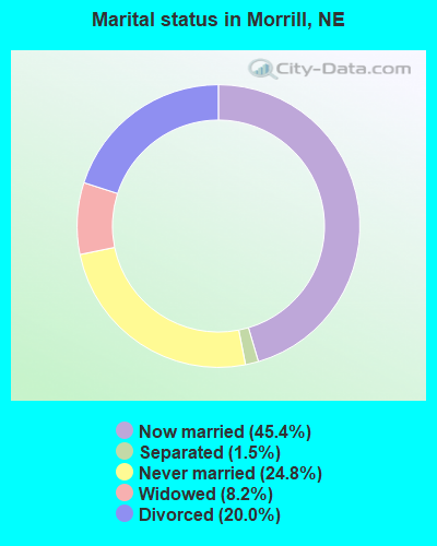
- Never married: 24.8%
- Now married: 45.4%
- Separated: 1.5%
- Widowed: 8.2%
- Divorced: 20.0%
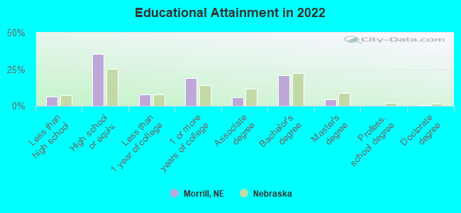
For population 25 years and over in Morrill:
- High school or higher: 92.9%
- Bachelor's degree or higher: 24.7%
- Graduate or professional degree: 4.9%
- Unemployed: 3.2%
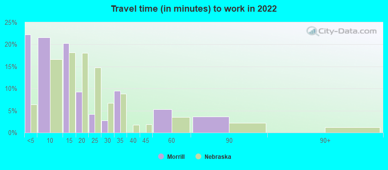
- Mean travel time to work (commute): 25.8 minutes
| Here: | 8.0 |
| Nebraska average: | 11.2 |
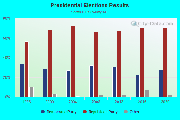
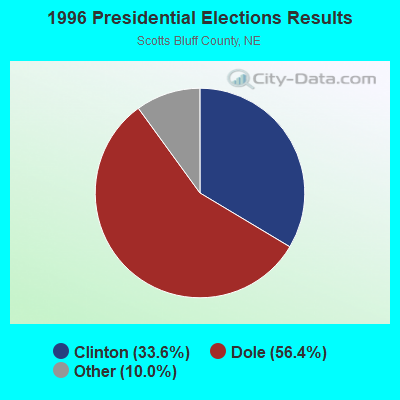

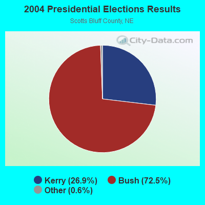
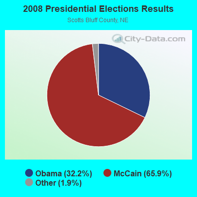


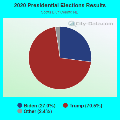
Graphs represent county-level data. Detailed 2008 Election Results
Religion statistics for Morrill, NE (based on Scotts Bluff County data)
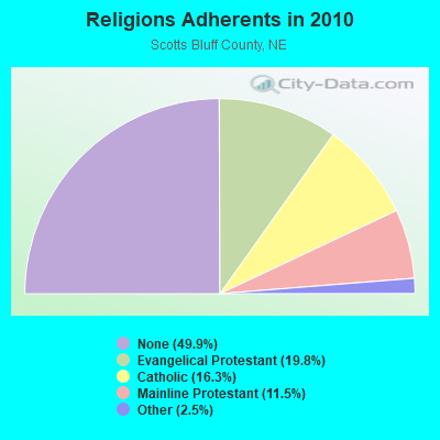
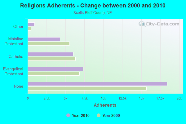
| Religion | Adherents | Congregations |
|---|---|---|
| Evangelical Protestant | 7,337 | 44 |
| Catholic | 6,036 | 6 |
| Mainline Protestant | 4,246 | 16 |
| Other | 916 | 5 |
| Orthodox | - | - |
| None | 18,435 | - |
Food Environment Statistics:
| Here: | 1.93 / 10,000 pop. |
| State: | 2.60 / 10,000 pop. |
| Scotts Bluff County: | 0.28 / 10,000 pop. |
| Nebraska: | 0.21 / 10,000 pop. |
| Scotts Bluff County: | 0.55 / 10,000 pop. |
| State: | 0.44 / 10,000 pop. |
| Scotts Bluff County: | 3.86 / 10,000 pop. |
| State: | 4.83 / 10,000 pop. |
| Here: | 10.47 / 10,000 pop. |
| Nebraska: | 7.76 / 10,000 pop. |
| This county: | 9.9% |
| Nebraska: | 7.9% |
| Scotts Bluff County: | 30.3% |
| Nebraska: | 28.0% |
| Scotts Bluff County: | 16.6% |
| Nebraska: | 12.9% |
Health and Nutrition:
| This city: | 48.4% |
| Nebraska: | 48.9% |
| Here: | 43.5% |
| Nebraska: | 45.5% |
| Morrill: | 29.0 |
| State: | 28.6 |
| Morrill: | 20.7% |
| State: | 21.4% |
| Morrill: | 13.8% |
| State: | 10.5% |
| Morrill: | 6.8 |
| State: | 6.8 |
| Morrill: | 37.0% |
| State: | 33.5% |
| Morrill: | 51.3% |
| Nebraska: | 55.6% |
| Morrill: | 73.5% |
| Nebraska: | 78.2% |
More about Health and Nutrition of Morrill, NE Residents
| Local government employment and payroll (March 2022) | |||||
| Function | Full-time employees | Monthly full-time payroll | Average yearly full-time wage | Part-time employees | Monthly part-time payroll |
|---|---|---|---|---|---|
| Parks and Recreation | 13 | $66,306 | $61,206 | 5 | $2,529 |
| Other Government Administration | 7 | $13,288 | $22,779 | 0 | $0 |
| Other and Unallocable | 5 | $25,686 | $61,646 | 0 | $0 |
| Electric Power | 3 | $20,005 | $80,020 | 1 | $197 |
| Police Protection - Officers | 2 | $12,920 | $77,520 | 2 | $2,883 |
| Water Supply | 2 | $2,701 | $16,206 | 0 | $0 |
| Sewerage | 2 | $8,184 | $49,104 | 0 | $0 |
| Streets and Highways | 2 | $1,391 | $8,346 | 0 | $0 |
| Solid Waste Management | 0 | $0 | 1 | $461 | |
| Local Libraries | 0 | $0 | 2 | $3,262 | |
| Totals for Government | 36 | $150,480 | $50,160 | 11 | $9,331 |
Morrill government finances - Expenditure in 2018 (per resident):
- Construction - Regular Highways: $200,000 ($217.39)
- Current Operations - Electric Utilities: $1,787,000 ($1942.39)
Parks and Recreation: $293,000 ($318.48)
Sewerage: $282,000 ($306.52)
Police Protection: $210,000 ($228.26)
Central Staff Services: $202,000 ($219.57)
Water Utilities: $190,000 ($206.52)
Financial Administration: $155,000 ($168.48)
Local Fire Protection: $134,000 ($145.65)
Libraries: $98,000 ($106.52)
Regular Highways: $84,000 ($91.30)
General - Other: $60,000 ($65.22)
General Public Buildings: $31,000 ($33.70)
- General - Interest on Debt: $145,000 ($157.61)
- Other Capital Outlay - Electric Utilities: $236,000 ($256.52)
Police Protection: $12,000 ($13.04)
Local Fire Protection: $8,000 ($8.70)
Water Utilities: $1,000 ($1.09)
- Total Salaries and Wages: $1,657,000 ($1801.09)
Morrill government finances - Revenue in 2018 (per resident):
- Charges - Sewerage: $472,000 ($513.04)
Parks and Recreation: $64,000 ($69.57)
- Local Intergovernmental - General Local Government Support: $1,000 ($1.09)
- Miscellaneous - General Revenue - Other: $406,000 ($441.30)
Interest Earnings: $19,000 ($20.65)
- Revenue - Electric Utilities: $2,394,000 ($2602.17)
Water Utilities: $285,000 ($309.78)
- State Intergovernmental - Highways: $110,000 ($119.57)
General Local Government Support: $61,000 ($66.30)
Other: $1,000 ($1.09)
- Tax - Other License: $624,000 ($678.26)
Property: $211,000 ($229.35)
General Sales and Gross Receipts: $122,000 ($132.61)
Morrill government finances - Debt in 2018 (per resident):
- Long Term Debt - Beginning Outstanding - Unspecified Public Purpose: $3,748,000 ($4073.91)
Outstanding Unspecified Public Purpose: $3,631,000 ($3946.74)
Retired Unspecified Public Purpose: $271,000 ($294.57)
Issue, Unspecified Public Purpose: $153,000 ($166.30)
Morrill government finances - Cash and Securities in 2018 (per resident):
- Other Funds - Cash and Securities: $968,000 ($1052.17)
Businesses in Morrill, NE
- Chevrolet: 1
- Subway: 1
Strongest AM radio stations in Morrill:
- KOLT (1320 AM; 5 kW; SCOTTSBLUFF, NE; Owner: TRACY BROADCASTING CORP.)
- KIMB (1260 AM; 50 kW; KIMBALL, NE; Owner: G & L INVESTMENTS, LLC)
- KNEB (960 AM; 5 kW; SCOTTSBLUFF, NE; Owner: PANHANDLE BROADCASTING, INC.)
- KOAQ (690 AM; 1 kW; TERRYTOWN, NE; Owner: TRACY BROADCASTING CORPORATION)
- KLTT (670 AM; 50 kW; COMMERCE CITY, CO; Owner: KLZ RADIO, INC.)
- KKZN (760 AM; 50 kW; THORNTON, CO; Owner: JACOR BROADCASTING OF COLORADO, INC.)
- KTWO (1030 AM; 50 kW; CASPER, WY; Owner: CITICASTERS LICENSES, L.P.)
- KGOS (1490 AM; 1 kW; TORRINGTON, WY; Owner: MT. RUSHMORE BROADCASTING, INC.)
- KGAB (650 AM; 8 kW; ORCHARD VALLEY, WY; Owner: CITICASTERS LICENSES, L.P.)
- KOA (850 AM; 50 kW; DENVER, CO; Owner: JACOR BROADCASTING OF COLORADO, INC.)
- KSIR (1010 AM; 25 kW; BRUSH, CO; Owner: JMS BROADCASTING, LLC)
- KMXA (1090 AM; 50 kW; AURORA, CO; Owner: ENTRAVISION HOLDINGS, LLC)
- KUYO (830 AM; daytime; 25 kW; EVANSVILLE, WY; Owner: WYOMING CHRISTIAN BROADCASTING COMPANY)
Strongest FM radio stations in Morrill:
- KOLT-FM (101.3 FM; BRIDGEPORT, NE; Owner: TRACY BROADCASTING CORPORATION)
- KMOR (92.9 FM; SCOTTSBLUFF, NE; Owner: TRACY BROADCASTING CORPORATION)
- KOZY-FM (103.9 FM; GERING, NE; Owner: TRACY BROADCASTING CORPORATION)
- KNEB-FM (94.1 FM; SCOTTSBLUFF, NE; Owner: PANHANDLE BROADCASTING, INC.)
- KERM (98.3 FM; TORRINGTON, WY; Owner: MT. RUSHMORE BROADCASTING, INC.)
- KCMI (96.9 FM; TERRYTOWN, NE; Owner: CHRISTIAN MEDIA INCORPORATED)
- KTNE-FM (91.1 FM; ALLIANCE, NE; Owner: NEBRASKA EDUCATIONAL TELECOMMUNICATIONS COMM.)
- KLJV (88.3 FM; SCOTTSBLUFF, NE; Owner: EDUCATIONAL MEDIA FOUNDATION)
- KREO (105.3 FM; PINE BLUFFS, WY; Owner: LARAMIE MOUNTAIN BROADCASTING, L.L.C.)
- K208CK (89.5 FM; SCOTTSBLUFF, NE; Owner: BIBLE BROADCASTING NETWORK, INC.)
- K212EJ (90.3 FM; SCOTTSBLUFF, NE; Owner: CALVARY CHAPEL OF TWIN FALLS, INC.)
TV broadcast stations around Morrill:
- KSTF (Channel 10; SCOTTSBLUFF, NE; Owner: CHELSEY BROADCASTING COMPANY OF CHEYENNE, LLC)
- K23EU (Channel 31; COLUMBUS, ETC, NE; Owner: DAVID C. BROADAHL)
- K33EM (Channel 33; COLUMBUS, ETC., NE; Owner: DAVID C. BRODAHL)
- K65GE (Channel 65; COLUMBUS-FREMONT, NE; Owner: ROGER E. HARDERS)
- KDUH-TV (Channel 4; SCOTTSBLUFF, NE; Owner: DUHAMEL BROADCASTING ENTERPRISES)
- KTNE-TV (Channel 13; ALLIANCE, NE; Owner: NEBRASKA EDUCATIONAL TELECOMMUNICATIONS COMM.)
- National Bridge Inventory (NBI) Statistics
- 19Number of bridges
- 128ft / 39.1mTotal length
- 16,225Total average daily traffic
- 1,454Total average daily truck traffic
- New bridges - historical statistics
- 11910-1919
- 21930-1939
- 21950-1959
- 41960-1969
- 11970-1979
- 11980-1989
- 31990-1999
- 42000-2009
- 12010-2019
FCC Registered Antenna Towers:
34 (See the full list of FCC Registered Antenna Towers in Morrill)FCC Registered Private Land Mobile Towers:
1 (See the full list of FCC Registered Private Land Mobile Towers in Morrill, NE)FCC Registered Broadcast Land Mobile Towers:
10 (See the full list of FCC Registered Broadcast Land Mobile Towers)FCC Registered Microwave Towers:
44 (See the full list of FCC Registered Microwave Towers in this town)FCC Registered Amateur Radio Licenses:
5- Call Sign: K0LJK, Grant Date: 11/28/1995, Expiration Date: 11/28/2005, Cancellation Date: 11/29/2007, Registrant: Alfred K Marron, Box 515, Morrill, NE 69358
- Call Sign: KB0JPN, Licensee ID: L00476322, Grant Date: 10/28/2022, Expiration Date: 10/28/2032, Registrant: Floyd Smith Iii, 402 Adams Ave, Morrill, NE 69358-0176
- Call Sign: KB0MFS, Grant Date: 03/29/1994, Expiration Date: 03/29/2004, Cancellation Date: 03/30/2006, Registrant: Kenneth L Shuster, Morrill, NE 69358
- Call Sign: WA0RPB, Grant Date: 05/24/1994, Expiration Date: 05/24/2004, Cancellation Date: 05/25/2006, Registrant: Randolph S Svitak, Route 1 Box 123a, Morrill, NE 69358
- Call Sign: KD0JGM, Licensee ID: L01525967, Grant Date: 04/22/2020, Expiration Date: 04/22/2030, Certifier: Marty L Ryan, Registrant: Marty L Ryan, 317 East Hamilton Street, Morrill, NE 69358
FAA Registered Aircraft:
2- Aircraft: CESSNA 182F (Category: Land, Seats: 4, Weight: Up to 12,499 Pounds, Speed: 119 mph), Engine: CONT MOTOR O-470 SERIES (230 HP) (Reciprocating)
N-Number: 3209U, N3209U, N-3209U, Serial Number: 18254609, Year manufactured: 1963, Certificate Issue Date: 10/09/2015
Registrant (Individual): Tommy Lee Watson, Po Box 366, Morrill, NE 69358 - Aircraft: PIPER PA-28-140 (Category: Land, Seats: 4, Weight: Up to 12,499 Pounds, Speed: 107 mph), Engine: LYCOMING 0-320 SERIES (180 HP) (Reciprocating)
N-Number: 5554U, N5554U, N-5554U, Serial Number: 28-26279, Year manufactured: 1969, Airworthiness Date: 08/19/1969, Certificate Issue Date: 08/31/2011
Registrant (LLC): Bff Cherokee LLC, 103 Adams Rd, Morrill, NE 69358
2002 - 2018 National Fire Incident Reporting System (NFIRS) incidents
- Fire incident types reported to NFIRS in Morrill, NE
- 11277.8%Outside Fires
- 1913.2%Structure Fires
- 106.9%Mobile Property/Vehicle Fires
- 32.1%Other
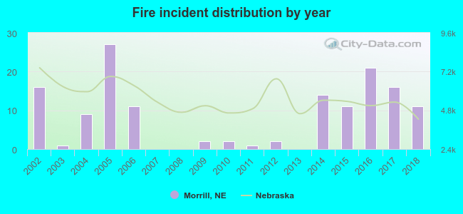 Based on the data from the years 2002 - 2018 the average number of fires per year is 8. The highest number of fire incidents - 27 took place in 2005, and the least - 0 in 2007. The data has a decreasing trend.
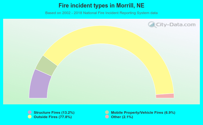 When looking into fire subcategories, the most incidents belonged to: Outside Fires (77.8%), and Structure Fires (13.2%).
| Most common first names in Morrill, NE among deceased individuals | ||
| Name | Count | Lived (average) |
|---|---|---|
| Mary | 21 | 78.7 years |
| John | 20 | 76.9 years |
| William | 14 | 74.6 years |
| James | 12 | 79.9 years |
| Henry | 11 | 80.5 years |
| George | 11 | 79.6 years |
| Robert | 10 | 69.4 years |
| Charles | 9 | 76.5 years |
| Helen | 8 | 80.8 years |
| Nellie | 7 | 84.4 years |
| Most common last names in Morrill, NE among deceased individuals | ||
| Last name | Count | Lived (average) |
|---|---|---|
| Schultz | 11 | 76.3 years |
| Smith | 7 | 76.1 years |
| Cook | 6 | 85.8 years |
| Baker | 6 | 80.5 years |
| Rose | 5 | 80.4 years |
| Reed | 5 | 82.4 years |
| Ramirez | 5 | 66.2 years |
| Jensen | 5 | 81.8 years |
| Brown | 5 | 78.4 years |
| Wilson | 5 | 75.4 years |
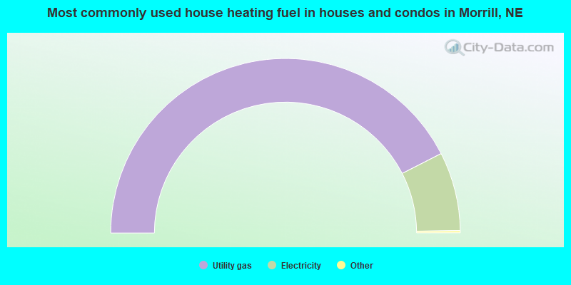
- 85.3%Utility gas
- 14.7%Electricity
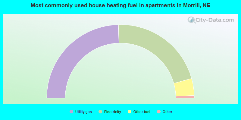
- 49.7%Utility gas
- 42.8%Electricity
- 7.6%Other fuel
Morrill compared to Nebraska state average:
- Median household income below state average.
- Median house value below state average.
- Unemployed percentage significantly below state average.
- Black race population percentage significantly below state average.
- Foreign-born population percentage significantly below state average.
- Length of stay since moving in above state average.
- Number of college students significantly below state average.