Montrose, Wisconsin
Submit your own pictures of this town and show them to the world
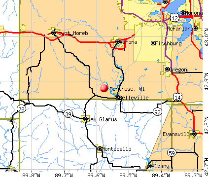
- OSM Map
- General Map
- Google Map
- MSN Map
Population change since 2000: -4.7%
 |
| Males: 557 | |
| Females: 524 |
| Median resident age: | 47.0 years |
| Wisconsin median age: | 42.6 years |
Zip codes: 53508.
| Montrose: | $103,096 |
| WI: | $70,996 |
Estimated per capita income in 2022: $50,058 (it was $24,364 in 2000)
Montrose town income, earnings, and wages data
Estimated median house or condo value in 2022: $399,487 (it was $156,800 in 2000)
| Montrose: | $399,487 |
| WI: | $252,800 |
Mean prices in 2022: all housing units: $411,151; detached houses: $438,642; townhouses or other attached units: $279,342; in 2-unit structures: $335,997; in 3-to-4-unit structures: $260,203; in 5-or-more-unit structures: $281,289; mobile homes: $129,987
Detailed information about poverty and poor residents in Montrose, WI


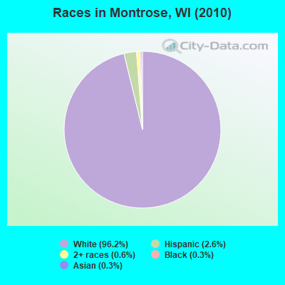
- 1,04096.2%White alone
- 282.6%Hispanic
- 70.6%Two or more races
- 30.3%Black alone
- 30.3%Asian alone
Races in Montrose detailed stats: ancestries, foreign born residents, place of birth
 Recent articles from our blog. Our writers, many of them Ph.D. graduates or candidates, create easy-to-read articles on a wide variety of topics.

 | Best areas to get land near Madison? (6 replies) |
Latest news from Montrose, WI collected exclusively by city-data.com from local newspapers, TV, and radio stations
Ancestries: German (46.1%), Swiss (18.7%), Irish (16.1%), Norwegian (14.6%), English (11.0%), French (8.6%).
Current Local Time: CST time zone
Elevation: 985 feet
Land area: 34.3 square miles.
Population density: 32 people per square mile (very low).
8 residents are foreign born
| This town: | 0.7% |
| Wisconsin: | 3.6% |
| Montrose town: | 1.8% ($2,893) |
| Wisconsin: | 2.0% ($2,245) |
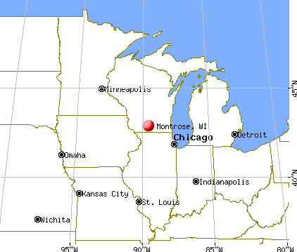
Nearest city with pop. 50,000+: Madison, WI  (14.2 miles , pop. 208,054).
Nearest city with pop. 1,000,000+: Chicago, IL (120.4 miles , pop. 2,896,016).
Nearest cities:
), ), ), Latitude: 42.90 N, Longitude: 89.55 W
Area code commonly used in this area: 608

| Here: | 2.0% |
| Wisconsin: | 2.7% |
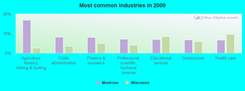
- Agriculture, forestry, fishing & hunting (16.9%)
- Public administration (8.2%)
- Finance & insurance (8.0%)
- Professional, scientific, technical services (7.2%)
- Educational services (6.9%)
- Construction (6.8%)
- Health care (6.6%)
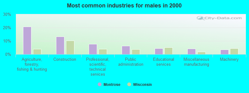
- Agriculture, forestry, fishing & hunting (20.7%)
- Construction (13.4%)
- Professional, scientific, technical services (7.6%)
- Public administration (6.3%)
- Educational services (4.4%)
- Miscellaneous manufacturing (4.1%)
- Machinery (3.5%)
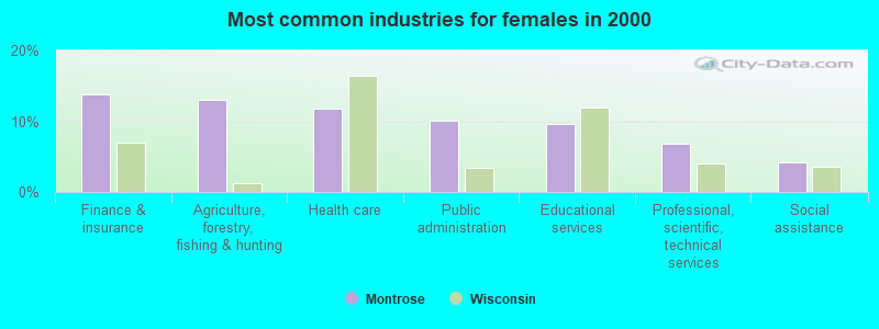
- Finance & insurance (13.8%)
- Agriculture, forestry, fishing & hunting (13.0%)
- Health care (11.8%)
- Public administration (10.1%)
- Educational services (9.6%)
- Professional, scientific, technical services (6.8%)
- Social assistance (4.2%)
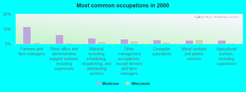
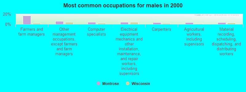
- Farmers and farm managers (11.5%)
- Other office and administrative support workers, including supervisors (6.1%)
- Material recording, scheduling, dispatching, and distributing workers (3.9%)
- Other management occupations, except farmers and farm managers (3.3%)
- Computer specialists (2.8%)
- Metal workers and plastic workers (2.5%)
- Agricultural workers, including supervisors (2.5%)
- Farmers and farm managers (16.9%)
- Other management occupations, except farmers and farm managers (6.0%)
- Computer specialists (4.4%)
- Electrical equipment mechanics and other installation, maintenance, and repair workers, including supervisors (4.1%)
- Carpenters (3.8%)
- Agricultural workers, including supervisors (3.8%)
- Material recording, scheduling, dispatching, and distributing workers (3.8%)
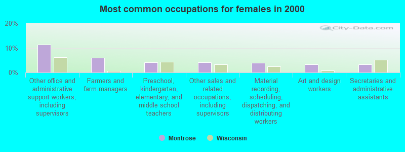
- Other office and administrative support workers, including supervisors (11.3%)
- Farmers and farm managers (5.9%)
- Preschool, kindergarten, elementary, and middle school teachers (4.2%)
- Other sales and related occupations, including supervisors (4.2%)
- Material recording, scheduling, dispatching, and distributing workers (3.9%)
- Art and design workers (3.4%)
- Secretaries and administrative assistants (3.4%)
Average climate in Montrose, Wisconsin
Based on data reported by over 4,000 weather stations


(lower is better)
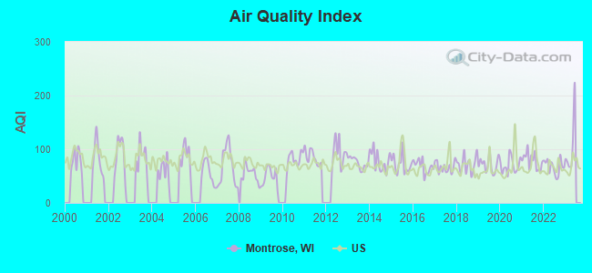
Air Quality Index (AQI) level in 2022 was 67.3. This is about average.
| City: | 67.3 |
| U.S.: | 72.6 |
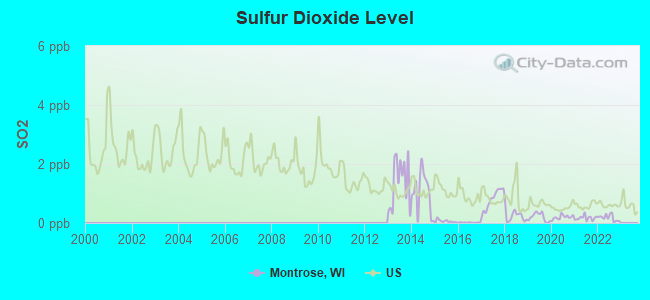
Sulfur Dioxide (SO2) [ppb] level in 2022 was 0.176. This is significantly better than average. Closest monitor was 13.6 miles away from the city center.
| City: | 0.176 |
| U.S.: | 1.515 |
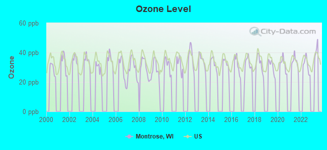
Ozone [ppb] level in 2022 was 31.5. This is about average. Closest monitor was 10.7 miles away from the city center.
| City: | 31.5 |
| U.S.: | 33.3 |
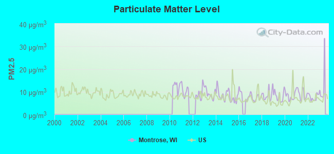
Particulate Matter (PM2.5) [µg/m3] level in 2022 was 7.63. This is about average. Closest monitor was 15.1 miles away from the city center.
| City: | 7.63 |
| U.S.: | 8.11 |
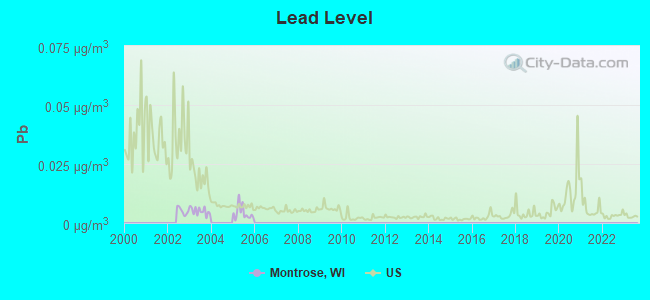
Lead (Pb) [µg/m3] level in 2005 was 0.00428. This is significantly better than average. Closest monitor was 13.6 miles away from the city center.
| City: | 0.00428 |
| U.S.: | 0.00931 |
Tornado activity:
Montrose-area historical tornado activity is above Wisconsin state average. It is 67% greater than the overall U.S. average.
On 6/7/1984, a category F5 (max. wind speeds 261-318 mph) tornado 22.4 miles away from the Montrose town center killed 9 people and injured 200 people and caused between $50,000 and $500,000 in damages.
On 6/17/1992, a category F3 (max. wind speeds 158-206 mph) tornado 1.7 miles away from the town center injured 30 people and caused between $5,000,000 and $50,000,000 in damages.
Earthquake activity:
Montrose-area historical earthquake activity is significantly above Wisconsin state average. It is 46% greater than the overall U.S. average.On 4/18/2008 at 09:36:59, a magnitude 5.4 (5.1 MB, 4.8 MS, 5.4 MW, 5.2 MW, Class: Moderate, Intensity: VI - VII) earthquake occurred 319.9 miles away from the city center
On 6/28/2004 at 06:10:52, a magnitude 4.2 (4.2 MW, Depth: 6.2 mi, Class: Light, Intensity: IV - V) earthquake occurred 105.1 miles away from Montrose center
On 6/10/1987 at 23:48:54, a magnitude 5.1 (4.9 MB, 4.4 MS, 4.6 MS, 5.1 LG) earthquake occurred 295.3 miles away from the city center
On 4/18/2008 at 09:36:59, a magnitude 5.2 (5.2 MW, Depth: 8.9 mi) earthquake occurred 319.9 miles away from the city center
On 2/10/2010 at 09:59:35, a magnitude 3.8 (3.8 MW, Depth: 6.2 mi, Class: Light, Intensity: II - III) earthquake occurred 83.8 miles away from Montrose center
On 6/18/2002 at 17:37:15, a magnitude 5.0 (4.3 MB, 4.6 MW, 5.0 LG) earthquake occurred 352.4 miles away from Montrose center
Magnitude types: regional Lg-wave magnitude (LG), body-wave magnitude (MB), surface-wave magnitude (MS), moment magnitude (MW)
Natural disasters:
The number of natural disasters in Dane County (18) is near the US average (15).Major Disasters (Presidential) Declared: 13
Emergencies Declared: 4
Causes of natural disasters: Storms: 12, Floods: 9, Tornadoes: 8, Winds: 2, Winter Storms: 2, Drought: 1, Hurricane: 1, Landslide: 1, Snow: 1, Snowstorm: 1, Other: 1 (Note: some incidents may be assigned to more than one category).
Hospitals and medical centers near Montrose:
- FOUR WINDS MANOR (Nursing Home, about 7 miles away; VERONA, WI)
- BADGER PRAIRIE HCC (Nursing Home, about 7 miles away; VERONA, WI)
- NEW GLARUS HOME (Nursing Home, about 8 miles away; NEW GLARUS, WI)
- ST MARYS CARE CTR (Nursing Home, about 8 miles away; MADISON, WI)
- OREGON MANOR (Nursing Home, about 9 miles away; OREGON, WI)
- HOSPICECARE (Hospital, about 10 miles away; MADISON, WI)
- INDEPENDENT HLTH CARE (Home Health Center, about 11 miles away; MADISON, WI)
Colleges/universities with over 2000 students nearest to Montrose:
- Edgewood College (about 13 miles; Madison, WI; Full-time enrollment: 2,455)
- University of Wisconsin Colleges (about 14 miles; Madison, WI; FT enrollment: 10,019)
- University of Wisconsin-Madison (about 14 miles; Madison, WI; FT enrollment: 34,621)
- Madison Area Technical College (about 19 miles; Madison, WI; FT enrollment: 9,603)
- Herzing University-Madison (about 22 miles; Madison, WI; FT enrollment: 3,160)
- University of Wisconsin-Whitewater (about 42 miles; Whitewater, WI; FT enrollment: 11,124)
- University of Wisconsin-Platteville (about 50 miles; Platteville, WI; FT enrollment: 7,679)
Points of interest:
Cemeteries: Saint Williams Cemetery (1), Paoli Cemetery (2). Display/hide their locations on the map
Rivers and creeks: Milum Creek (A), Flynn Creek (B), West Branch Sugar River (C). Display/hide their locations on the map
| This town: | 2.5 people |
| Wisconsin: | 2.4 people |
| This town: | 74.0% |
| Whole state: | 64.4% |
| This town: | 6.9% |
| Whole state: | 7.3% |
Likely homosexual households (counted as self-reported same-sex unmarried-partner households)
- Lesbian couples: 0.2% of all households
- Gay men: 0.5% of all households
| This town: | 1.6% |
| Whole state: | 8.7% |
| This town: | 0.5% |
| Whole state: | 3.7% |
For population 15 years and over in Montrose:
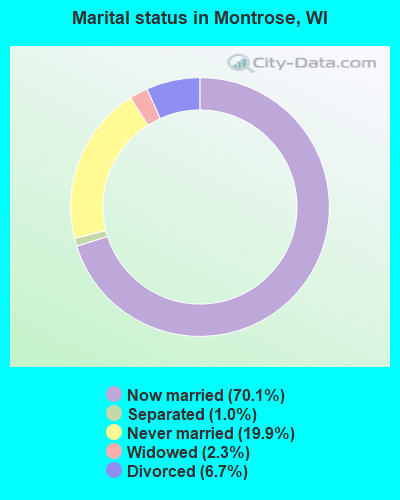
- Never married: 19.9%
- Now married: 70.1%
- Separated: 1.0%
- Widowed: 2.3%
- Divorced: 6.7%
For population 25 years and over in Montrose:
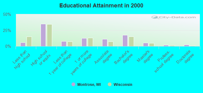
- High school or higher: 94.1%
- Bachelor's degree or higher: 27.4%
- Graduate or professional degree: 10.1%
- Unemployed: 2.0%
- Mean travel time to work (commute): 24.6 minutes
| Here: | 10.4 |
| Wisconsin average: | 11.0 |
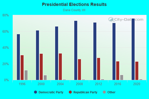
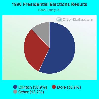
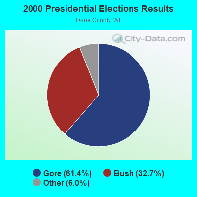

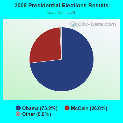
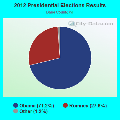
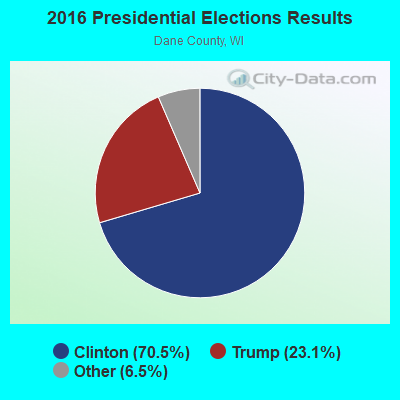
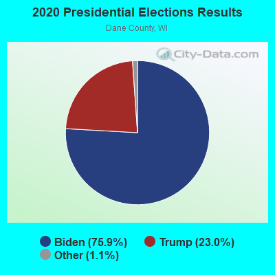
Graphs represent county-level data. Detailed 2008 Election Results
Religion statistics for Montrose, WI (based on Dane County data)
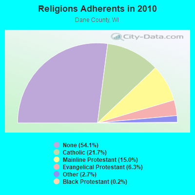
| Religion | Adherents | Congregations |
|---|---|---|
| Catholic | 106,036 | 34 |
| Mainline Protestant | 73,128 | 113 |
| Evangelical Protestant | 30,727 | 146 |
| Other | 12,968 | 49 |
| Black Protestant | 779 | 5 |
| Orthodox | 445 | 4 |
| None | 263,990 | - |
Food Environment Statistics:
| Dane County: | 1.53 / 10,000 pop. |
| Wisconsin: | 1.86 / 10,000 pop. |
| Dane County: | 0.04 / 10,000 pop. |
| Wisconsin: | 0.11 / 10,000 pop. |
| Here: | 0.11 / 10,000 pop. |
| Wisconsin: | 0.38 / 10,000 pop. |
| Dane County: | 3.24 / 10,000 pop. |
| Wisconsin: | 4.12 / 10,000 pop. |
| Dane County: | 8.03 / 10,000 pop. |
| Wisconsin: | 8.64 / 10,000 pop. |
| Here: | 6.0% |
| Wisconsin: | 7.6% |
| Dane County: | 23.9% |
| Wisconsin: | 27.5% |
| Dane County: | 11.1% |
| Wisconsin: | 13.0% |
5.62% of this county's 2021 resident taxpayers lived in other counties in 2020 ($67,560 average adjusted gross income)
| Here: | 5.62% |
| Wisconsin average: | 6.07% |
0.01% of residents moved from foreign countries ($96 average AGI)
Dane County: 0.01% Wisconsin average: 0.00%
Top counties from which taxpayers relocated into this county between 2020 and 2021:
| from Milwaukee County, WI | |
| from Cook County, IL | |
| from Rock County, WI |
6.55% of this county's 2020 resident taxpayers moved to other counties in 2021 ($75,791 average adjusted gross income)
| Here: | 6.55% |
| Wisconsin average: | 6.10% |
0.01% of residents moved to foreign countries ($41 average AGI)
Dane County: 0.01% Wisconsin average: 0.00%
Top counties to which taxpayers relocated from this county between 2020 and 2021:
| to Rock County, WI | |
| to Columbia County, WI | |
| to Milwaukee County, WI |
Strongest AM radio stations in Montrose:
- WLMV (1480 AM; 10 kW; MADISON, WI; Owner: MID-WEST MANAGEMENT, INC.)
- WTSO (1070 AM; 10 kW; MADISON, WI; Owner: CAPSTAR TX LIMITED PARTNERSHIP)
- WIBA (1310 AM; 5 kW; MADISON, WI; Owner: CAPSTAR TX LIMITED PARTNERSHIP)
- WTDY (1670 AM; 10 kW; MADISON, WI; Owner: MID-WEST MANAGEMENT, INC.)
- WHA (970 AM; 5 kW; MADISON, WI; Owner: BOARD REGENTS OF UNIV OF WI SYSTEM)
- WTUX (1550 AM; daytime; 5 kW; MADISON, WI)
- WTMJ (620 AM; 50 kW; MILWAUKEE, WI; Owner: JOURNAL BROADCAST CORPORATION)
- WISN (1130 AM; 50 kW; MILWAUKEE, WI; Owner: CAPSTAR TX LIMITED PARTNERSHIP)
- WSCR (670 AM; 50 kW; CHICAGO, IL; Owner: INFINITY BROADCASTING OPERATIONS, INC.)
- WGN (720 AM; 50 kW; CHICAGO, IL; Owner: WGN CONTINENTAL BROADCASTING CO.)
- WNWC (1190 AM; daytime; 5 kW; SUN PRAIRIE, WI; Owner: NORTHWESTERN COLLEGE)
- WBBM (780 AM; 50 kW; CHICAGO, IL; Owner: INFINITY BROADCASTING OPERATIONS, INC.)
- WNAM (1280 AM; 50 kW; NEENAH-MENASHA, WI; Owner: CUMULUS LICENSING CORP.)
Strongest FM radio stations in Montrose:
- WSUM (91.7 FM; MADISON, WI; Owner: BD. OF REGENTS OF UNIVERSITY OF WISCONSIN SYSTEM)
- WMMM-FM (105.5 FM; VERONA, WI; Owner: ENTERCOM MADISON LICENSE, LLC.)
- WERN (88.7 FM; MADISON, WI; Owner: STATE OF WISCONSIN - EDUCATIONAL COMMUNICATIONS BOARD)
- WIBA-FM (101.5 FM; MADISON, WI; Owner: CAPSTAR TX LIMITED PARTNERSHIP)
- WZEE (104.1 FM; MADISON, WI; Owner: CAPSTAR TX LIMITED PARTNERSHIP)
- WORT (89.9 FM; MADISON, WI; Owner: BACK PORCH RADIO BROADCASTING, INC.)
- WMGN (98.1 FM; MADISON, WI; Owner: MID-WEST MANAGEMENT, INC.)
- W215AQ (90.9 FM; MADISON, WI; Owner: STATE OF WISCONSIN - EDUCATIONAL COMMUNICATIONS BOARD)
- WNWC-FM (102.5 FM; MADISON, WI; Owner: NORTHWESTERN COLLEGE)
- WWQM-FM (106.3 FM; MIDDLETON, WI; Owner: MID-WEST MANAGEMENT INC.)
- WCJZ (96.3 FM; SAUK CITY, WI; Owner: CAPSTAR TX LIMITED PARTNERSHIP)
- WOLX-FM (94.9 FM; BARABOO, WI; Owner: ENTERCOM MADISON LICENSE, LLC.)
- WKPO (105.9 FM; EVANSVILLE, WI; Owner: GOOD KARMA BROADCASTING, L.L.C.)
- WSJY (107.3 FM; FORT ATKINSON, WI; Owner: NEWRADIO GROUP, LLC)
- WEKZ-FM (93.7 FM; MONROE, WI; Owner: RONALD M.SPIELMAN & SCOTT THOMPSON)
- WJVL (99.9 FM; JANESVILLE, WI; Owner: SOUTHERN WISCONSIN BROADCASTING, L.L.C.)
- W277AE (103.3 FM; MADISON, WI; Owner: FAITH ACADEMY DBA WFEN)
- WJJO (94.1 FM; WATERTOWN, WI; Owner: MID-WEST MANAGMENT, INC.)
- WMAD-FM (92.1 FM; SUN PRAIRIE, WI; Owner: CAPSTAR TX LIMITED PARTNERSHIP)
- WDMP-FM (99.3 FM; DODGEVILLE, WI; Owner: DODGE POINT BROADCASTING CO., INC.)
TV broadcast stations around Montrose:
- WISC-TV (Channel 3; MADISON, WI; Owner: TELEVISION WISCONSIN, INC.)
- WMSN-TV (Channel 47; MADISON, WI; Owner: WMSN LICENSEE, LLC)
- WKOW-TV (Channel 27; MADISON, WI; Owner: WKOW TELEVISION, INC.)
- WHA-TV (Channel 21; MADISON, WI; Owner: BOARD OF REGENTS OF THE UNIV. OF WISCONSIN SYSTEM)
- WMTV (Channel 15; MADISON, WI; Owner: GRAY MIDAMERICA TV LICENSEE CORP.)
- W38CT (Channel 38; MADISON, WI; Owner: TRINITY BROADCASTING NETWORK)
- W23BW (Channel 23; MADISON, WI; Owner: THREE ANGELS BROADCASTING NETWORK)
- W58CO (Channel 58; SAULT STE. MARIE, MI; Owner: MS COMMUNICATIONS, LLC)
- W08CK (Channel 8; MADISON-MIDDLETON, WI; Owner: HEALTHY'S, INC.)
- W65EE (Channel 65; JANESVILLE, WI; Owner: TRINITY BROADCASTING NETWORK)
- National Bridge Inventory (NBI) Statistics
- 14Number of bridges
- 105ft / 32.1mTotal length
- $1,127,000Total costs
- 24,877Total average daily traffic
- 140Total average daily truck traffic
- 31,421Total future (year 2036) average daily traffic
- New bridges - historical statistics
- 11930-1939
- 21950-1959
- 31980-1989
- 41990-1999
- 42010-2019
FCC Registered Antenna Towers:
7- B. Benjamin Evans, 0.3 Km Se Of Int Of Observatory Rd And County Trunk A (Lat: 42.904444 Lon: -89.555556), Type: 122.8, Overall height: 121.9 m, Registrant: University Of Wisconsin Board Of Regents Dba , Madis-on, Phone: (608) 262-9542
- Judith A Temby, 0.3 Km Se Of Int Of Observatory Rd And County Trunk A (Lat: 42.904444 Lon: -89.555556), Type: 122.8, Overall height: 121.9 m, Registrant: University Of Wisconsin Board Of Regents Dba , Madis-on, Phone: (608) 262-9542
- Jane S RADUE, 0.3 Km Se Of Int Of Observatory Rd And County Trunk A (Lat: 42.904528 Lon: -89.555917), Type: 122.8, Structure height: 55025 m, Overall height: 121.9 m, Registrant: University Of Wisconsin Board Of Regents Dba , Gm@wsum.Wisc.Edu, , Madis-on, Phone: (608) 262-9542
- Jessica A Lathrop, 0.3 Km Se Of Int Of Observatory Rd And County Trunk A (Lat: 42.904528 Lon: -89.555917), Type: 122.8, Structure height: 55025 m, Overall height: 121.9 m, Licensee ID: G, Registrant: University Of Wisconsin Board Of Regents Dba , Gm@wsum.Wisc.Edu, , Madis-on, Phone: (608) 262-9542
- Jessica A Lathrop, 0.3 Km Se Of Int Of Observatory Rd And County Trunk A (Lat: 42.904528 Lon: -89.555917), Type: 122.8, Structure height: 55025 m, Overall height: 121.9 m, Registrant: University Of Wisconsin Board Of Regents Dba Wsum Radio, Gm@wsum.Wisc.Edu, # 4100, Madis-on, Phone: (608) 262-9542
- 0.3 Km Se Of Intersection Of Observatory Rd And County Trunk A (Lat: 42.904444 Lon: -89.556111), Type: 37.4, Overall height: 37.4 m, Registrant: University Of Wisconsin Board Of Regents Dba , Madis-on, Phone: (608) 262-9542
- 0.3 Km Se Of Int Of Observatory Rd And County Trunk A (Lat: 42.904444 Lon: -89.555556), Type: 122.8, Overall height: 121.9 m, Registrant: University Of Wisconsin Board Of Regents Dba , Madis-on, Phone: (608) 262-9542
FCC Registered Microwave Towers:
1- WSUM TWR, 0.3 Km Se Of Intersection Observatory Rd And County Trunk (Lat: 42.904528 Lon: -89.555917), Type: Gtower, Structure height: 121.9 m, Overall height: 122.8 m, Call Sign: WRMY587,
Assigned Frequencies: 11215.0 MHz, 11215.0 MHz, 11215.0 MHz, 11215.0 MHz, 11215.0 MHz, 11215.0 MHz, Grant Date: 06/24/2021, Expiration Date: 06/24/2031, Certifier: Douglas L Vernier, Registrant: University Of Wisconsin - Madison, 333 East Campus Mail #4100, Madison, WI 53713, Phone: (608) 262-9542, Email:
- 40.3%Bottled, tank, or LP gas
- 32.6%Utility gas
- 19.7%Fuel oil, kerosene, etc.
- 6.3%Wood
- 1.1%Electricity
- 54.9%Bottled, tank, or LP gas
- 21.1%Utility gas
- 15.5%Fuel oil, kerosene, etc.
- 8.5%Electricity
Montrose compared to Wisconsin state average:
- Median house value above state average.
- Unemployed percentage significantly below state average.
- Black race population percentage significantly below state average.
- Hispanic race population percentage significantly below state average.
- Median age above state average.
- Foreign-born population percentage significantly below state average.
- Renting percentage below state average.
- Length of stay since moving in significantly above state average.
- Number of rooms per house significantly below state average.
- House age significantly below state average.