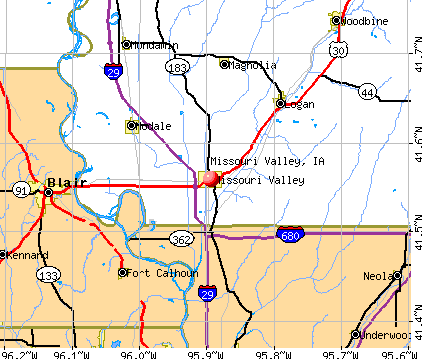
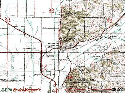
Missouri Valley, Iowa


Submit your own pictures of this city and show them to the world
- OSM Map
- General Map
- Google Map
- MSN Map
Population change since 2000: -10.5%
 |
| Males: 1,283 | |
| Females: 1,394 |
| Median resident age: | 40.1 years |
| Iowa median age: | 38.9 years |
Zip codes: 51555.
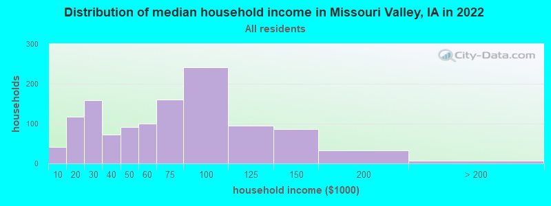
| Missouri Valley: | $60,624 |
| IA: | $69,588 |
Estimated per capita income in 2022: $30,049 (it was $18,031 in 2000)
Missouri Valley city income, earnings, and wages data
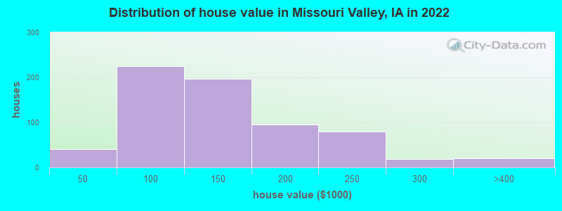
Estimated median house or condo value in 2022: $130,948 (it was $74,100 in 2000)
| Missouri Valley: | $130,948 |
| IA: | $194,600 |
Mean prices in 2022: all housing units: $137,473; detached houses: $144,804; townhouses or other attached units: $146,528; mobile homes: $50,990
Median gross rent in 2022: $779.
Missouri Valley, IA residents, houses, and apartments details
(9.1% for White Non-Hispanic residents, 21.3% for two or more races residents)
Detailed information about poverty and poor residents in Missouri Valley, IA


Compare current foreclosures near Missouri Valley, IA:
| Photo | Address | Area | Beds / Baths | Price | Details |
|---|---|---|---|---|---|

|
#1
N 9th St
Missouri Valley, IA 51555
|
1,562 sq. feet
|
1 baths 3 beds |
show details | |

|
#2
E Michigan St
Missouri Valley, IA 51555
|
1,132 sq. feet
|
1 baths 2 beds |
show details | |

|
#3
Muncie Ave
Missouri Valley, IA 51555
|
1,714 sq. feet
|
1 baths - beds |
show details | |

|
#4
N West St
Missouri Valley, IA 51555
|
1,269 sq. feet
|
1 baths - beds |
show details | |

|
#5
Oak Dr
Missouri Valley, IA 51555
|
- sq. feet
|
- baths - beds |
show details | |

|
#6
State St
Omaha, NE 68112
|
1,227 sq. feet
|
1 baths 2 beds |
show details | |

|
#7
Old Lincoln Hwy
Crescent, IA 51526
|
1,845 sq. feet
|
1 baths 3 beds |
show details | |

|
#8
Arrowhead Dr
Blair, NE 68008
|
1,979 sq. feet
|
2 baths 2 beds |
show details | |

|
#9
Spring Dr
Blair, NE 68008
|
2,204 sq. feet
|
2 baths 3 beds |
show details | |

|
#10
Minne Lusa Blvd
Omaha, NE 68112
|
1,984 sq. feet
|
2 baths 4 beds |
show details |
| Photo | Address | Area | Beds / Baths | Price | Details |
|---|---|---|---|---|---|

|
#11
N 31st St
Omaha, NE 68112
|
1,266 sq. feet
|
1 baths 2 beds |
show details | |

|
#12
Howell St
Omaha, NE 68122
|
1,505 sq. feet
|
2 baths 3 beds |
show details | |

|
#13
Tucker St
Omaha, NE 68112
|
1,680 sq. feet
|
1 baths 3 beds |
show details | |

|
#14
Leisure Ave
Crescent, IA 51526
|
970 sq. feet
|
1 baths 3 beds |
show details | |

|
#15
N 31st St
Omaha, NE 68112
|
1,660 sq. feet
|
1 baths 4 beds |
show details | |

|
#16
Sheffield St
Omaha, NE 68112
|
788 sq. feet
|
1 baths 2 beds |
show details | |

|
#17
Iowa St
Omaha, NE 68112
|
897 sq. feet
|
1 baths 2 beds |
show details | |

|
#18
Craig Ave
Omaha, NE 68112
|
604 sq. feet
|
1 baths 2 beds |
show details | |

|
#19
N 36th St
Omaha, NE 68112
|
1,314 sq. feet
|
1 baths 3 beds |
show details | |

|
#20
Arrowhead Dr
Blair, NE 68008
|
2,006 sq. feet
|
1 baths 3 beds |
show details |
| Photo | Address | Area | Beds / Baths | Price | Details |
|---|---|---|---|---|---|

|
#21
Whitmore St
Omaha, NE 68112
|
1,400 sq. feet
|
1 baths 2 beds |
show details | |

|
#22
Sharon Dr
Omaha, NE 68112
|
902 sq. feet
|
1 baths 2 beds |
show details | |

|
#23
Larsen Dr
Blair, NE 68008
|
1,681 sq. feet
|
1 baths 3 beds |
show details | |

|
#24
Ida St
Omaha, NE 68112
|
960 sq. feet
|
1 baths 3 beds |
show details | |

|
#25
W 4th St
Logan, IA 51546
|
1,250 sq. feet
|
1 baths 2 beds |
show details | |

|
#26
Ida St
Omaha, NE 68112
|
960 sq. feet
|
1 baths 3 beds |
show details | |

|
#27
Road L34
Neola, IA 51559
|
1,480 sq. feet
|
1 baths 3 beds |
show details | |

|
#28
N 32nd St
Omaha, NE 68112
|
1,280 sq. feet
|
1 baths 2 beds |
show details | |

|
#29
Cedar St
Mondamin, IA 51557
|
2,584 sq. feet
|
3 baths 5 beds |
show details | |

|
#30
Pinewood Dr
Blair, NE 68008
|
2,989 sq. feet
|
2 baths 4 beds |
show details |
| Photo | Address | Area | Beds / Baths | Price | Details |
|---|---|---|---|---|---|

|
#31
Newport Ave
Omaha, NE 68112
|
2,249 sq. feet
|
1 baths 3 beds |
show details | |

|
#32
Grant St
Blair, NE 68008
|
2,002 sq. feet
|
2 baths 3 beds |
show details | |

|
#33
N 36th Avenue Cir
Omaha, NE 68112
|
1,296 sq. feet
|
1 baths 3 beds |
show details | |

|
#34
Minne Lusa Blvd
Omaha, NE 68112
|
1,472 sq. feet
|
1 baths 3 beds |
show details | |

|
#35
N 37th St
Omaha, NE 68112
|
1,730 sq. feet
|
1 baths 3 beds |
show details | |

|
#36
Mckinley St
Omaha, NE 68152
|
2,245 sq. feet
|
- baths 4 beds |
show details | |

|
#37
Weber St
Omaha, NE 68112
|
- sq. feet
|
- baths - beds |
show details | |

|
#38
N 34th St
Omaha, NE 68112
|
- sq. feet
|
- baths - beds |
show details | |

|
#39
Bauman Ave
Omaha, NE 68112
|
- sq. feet
|
- baths - beds |
show details | |

|
#40
Ernst St
Omaha, NE 68112
|
- sq. feet
|
- baths - beds |
show details |
| Photo | Address | Area | Beds / Baths | Price | Details |
|---|---|---|---|---|---|

|
#41
Mckinley St Lot 46a
Omaha, NE 68112
|
- sq. feet
|
- baths - beds |
show details | |

|
#42
Read St Lot 21
Omaha, NE 68112
|
- sq. feet
|
- baths - beds |
show details | |

|
#43
Soren Dr
Blair, NE 68008
|
- sq. feet
|
- baths - beds |
show details | |

|
#44
E Palmer St
Modale, IA 51556
|
- sq. feet
|
- baths - beds |
show details | |

|
#45
2nd St
Magnolia, IA 51550
|
- sq. feet
|
- baths - beds |
show details | |

|
#46
Madison St Lot 1
Fort Calhoun, NE 68023
|
1,216 sq. feet
|
- baths - beds |
show details | |

|
#47
Iowa Ave Apt 2
Blair, NE 68008
|
- sq. feet
|
- baths - beds |
show details | |

|
#48
Lincoln St
Blair, NE 68008
|
1,273 sq. feet
|
- baths - beds |
show details | |

|
#49
N 18th Ave Apt 1b
Blair, NE 68008
|
- sq. feet
|
- baths - beds |
show details | |

|
Check over 1 million property listings on Foreclosure.com!
|
browse all offers | |||


- 2,56494.9%White alone
- 923.4%Two or more races
- 311.1%Hispanic
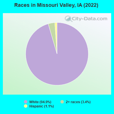
Races in Missouri Valley detailed stats: ancestries, foreign born residents, place of birth
According to our research of Iowa and other state lists, there were 5 registered sex offenders living in Missouri Valley, Iowa as of May 12, 2024.
The ratio of all residents to sex offenders in Missouri Valley is 543 to 1.
The ratio of registered sex offenders to all residents in this city is near the state average.
Type |
2011 |
2012 |
2014 |
2015 |
2016 |
2019 |
2020 |
|---|---|---|---|---|---|---|---|
| Murders (per 100,000) | 0 (0.0) | 0 (0.0) | 0 (0.0) | 0 (0.0) | 0 (0.0) | 0 (0.0) | 0 (0.0) |
| Rapes (per 100,000) | 0 (0.0) | 0 (0.0) | 1 (37.3) | 0 (0.0) | 0 (0.0) | 2 (76.7) | 1 (38.6) |
| Robberies (per 100,000) | 0 (0.0) | 0 (0.0) | 0 (0.0) | 1 (37.6) | 0 (0.0) | 0 (0.0) | 0 (0.0) |
| Assaults (per 100,000) | 6 (210.3) | 2 (70.6) | 0 (0.0) | 2 (75.2) | 2 (75.0) | 12 (459.9) | 8 (308.6) |
| Burglaries (per 100,000) | 6 (210.3) | 5 (176.6) | 7 (260.8) | 11 (413.8) | 15 (562.2) | 10 (383.3) | 10 (385.8) |
| Thefts (per 100,000) | 46 (1,612) | 20 (706.5) | 33 (1,230) | 36 (1,354) | 37 (1,387) | 33 (1,265) | 31 (1,196) |
| Auto thefts (per 100,000) | 4 (140.2) | 1 (35.3) | 1 (37.3) | 2 (75.2) | 5 (187.4) | 2 (76.7) | 4 (154.3) |
| Arson (per 100,000) | 0 (0.0) | 0 (0.0) | 0 (0.0) | 2 (75.2) | 2 (75.0) | 0 (0.0) | 0 (0.0) |
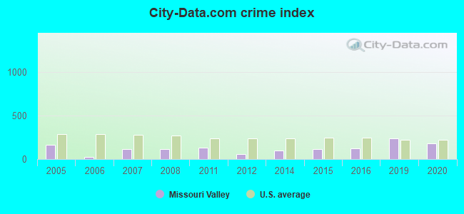
| City-Data.com crime index | 132.5 | 57.6 | 100.2 | 115.5 | 124.8 | 236.9 | 179.8 |
The City-Data.com crime index weighs serious crimes and violent crimes more heavily. Higher means more crime, U.S. average is 246.1. It adjusts for the number of visitors and daily workers commuting into cities.
Crime rate in Missouri Valley detailed stats: murders, rapes, robberies, assaults, burglaries, thefts, arson
Full-time law enforcement employees in 2019, including police officers: 6 (6 officers - 6 male; 0 female).
| Officers per 1,000 residents here: | 2.30 |
| Iowa average: | 1.75 |
 Recent articles from our blog. Our writers, many of them Ph.D. graduates or candidates, create easy-to-read articles on a wide variety of topics.

 | Interesting/quirky/off-the-beaten-path stuff to see in Iowa? (9 replies) |
| Is I-29 clear of flooding (7 replies) |
| Is Iowa life really that great? (127 replies) |
| College hoops and the state of Iowa (38 replies) |
| would Iowans like to see Iowa & Iowa State in the same conference (19 replies) |
| Mondamin Iowa...help (4 replies) |
Latest news from Missouri Valley, IA collected exclusively by city-data.com from local newspapers, TV, and radio stations
Ancestries: German (42.5%), Irish (10.9%), English (7.6%), American (6.9%), European (3.4%), Italian (2.7%).
Current Local Time: CST time zone
Incorporated on 10/30/1871
Elevation: 1019 feet
Land area: 3.04 square miles.
Population density: 879 people per square mile (low).
38 residents are foreign born
| This city: | 1.3% |
| Iowa: | 3.1% |
Median real estate property taxes paid for housing units with mortgages in 2022: $2,009 (1.4%)
Median real estate property taxes paid for housing units with no mortgage in 2022: $1,770 (1.9%)
Nearest city with pop. 50,000+: Council Bluffs, IA  (21.2 miles , pop. 58,268).
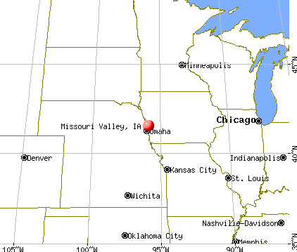
Nearest city with pop. 200,000+: Omaha, NE (21.5 miles , pop. 390,007).
Nearest city with pop. 1,000,000+: Chicago, IL (424.5 miles , pop. 2,896,016).
Nearest cities:
), ), ), Latitude: 41.56 N, Longitude: 95.89 W
Area code: 712
Missouri Valley, Iowa accommodation & food services, waste management - Economy and Business Data
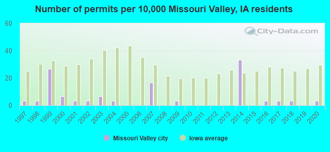
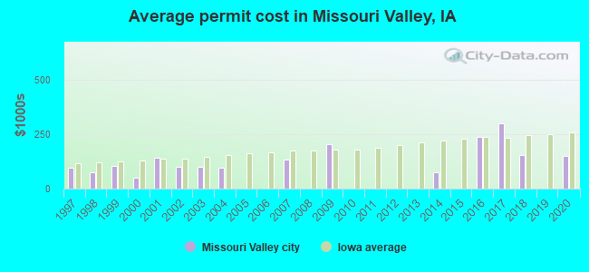
Single-family new house construction building permits:
- 2020: 1 building, cost: $150,000
- 2018: 1 building, cost: $156,000
- 2017: 1 building, cost: $300,000
- 2016: 1 building, cost: $236,000
- 2014: 10 buildings, average cost: $73,000
- 2009: 1 building, cost: $203,000
- 2007: 5 buildings, average cost: $132,400
- 2004: 1 building, cost: $95,000
- 2003: 2 buildings, average cost: $100,000
- 2002: 1 building, cost: $100,000
- 2001: 1 building, cost: $140,000
- 2000: 2 buildings, average cost: $50,000
- 1999: 8 buildings, average cost: $103,800
- 1998: 1 building, cost: $75,000
- 1997: 1 building, cost: $95,000
| Here: | 2.3% |
| Iowa: | 2.7% |

Population change in the 1990s: +84 (+2.9%).
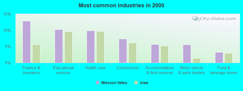
- Finance & insurance (12.8%)
- Educational services (10.3%)
- Health care (9.9%)
- Construction (7.4%)
- Accommodation & food services (5.7%)
- Motor vehicle & parts dealers (5.6%)
- Food & beverage stores (3.3%)
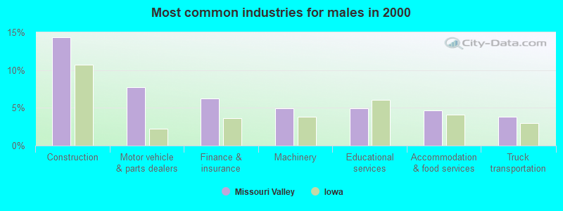
- Construction (14.3%)
- Motor vehicle & parts dealers (7.7%)
- Finance & insurance (6.2%)
- Machinery (4.9%)
- Educational services (4.9%)
- Accommodation & food services (4.6%)
- Truck transportation (3.9%)
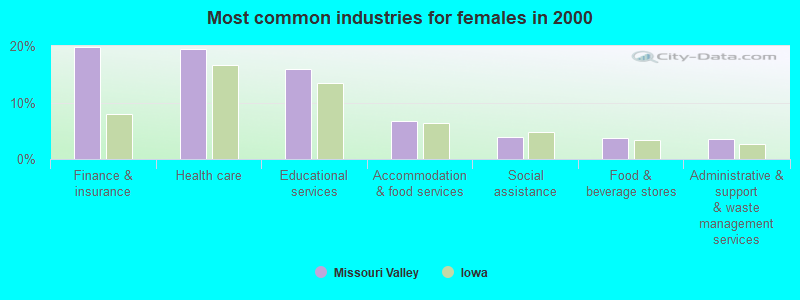
- Finance & insurance (19.8%)
- Health care (19.4%)
- Educational services (16.0%)
- Accommodation & food services (6.8%)
- Social assistance (4.0%)
- Food & beverage stores (3.7%)
- Administrative & support & waste management services (3.5%)

- Other sales and related occupations, including supervisors (5.2%)
- Preschool, kindergarten, elementary, and middle school teachers (4.8%)
- Other office and administrative support workers, including supervisors (4.7%)
- Other management occupations, except farmers and farm managers (4.4%)
- Driver/sales workers and truck drivers (4.4%)
- Secretaries and administrative assistants (3.7%)
- Sales representatives, services, wholesale and manufacturing (3.6%)

- Other sales and related occupations, including supervisors (7.8%)
- Other management occupations, except farmers and farm managers (6.9%)
- Driver/sales workers and truck drivers (5.8%)
- Material recording, scheduling, dispatching, and distributing workers (5.7%)
- Carpenters (5.6%)
- Metal workers and plastic workers (5.3%)
- Other material moving workers, except laborers (4.6%)
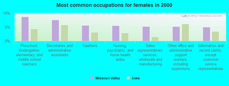
- Preschool, kindergarten, elementary, and middle school teachers (8.8%)
- Secretaries and administrative assistants (7.6%)
- Cashiers (5.7%)
- Nursing, psychiatric, and home health aides (5.5%)
- Sales representatives, services, wholesale and manufacturing (5.2%)
- Other office and administrative support workers, including supervisors (5.2%)
- Information and record clerks, except customer service representatives (5.1%)
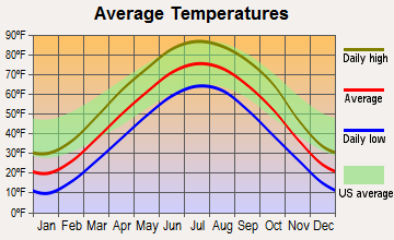
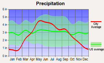
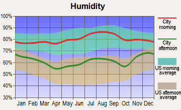
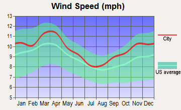
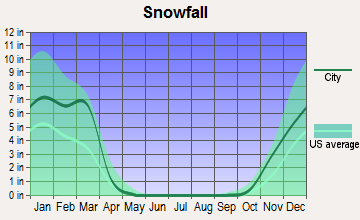
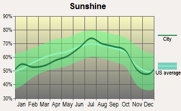
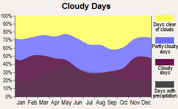
Average climate in Missouri Valley, Iowa
Based on data reported by over 4,000 weather stations
|
|


(lower is better)
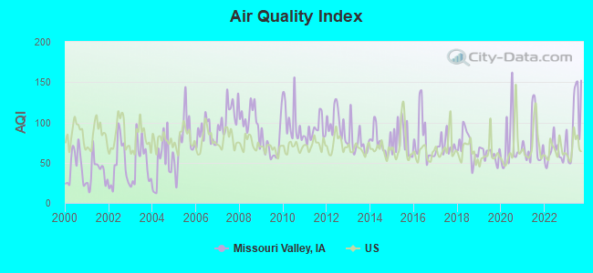
Air Quality Index (AQI) level in 2023 was 102. This is significantly worse than average.
| City: | 102 |
| U.S.: | 73 |
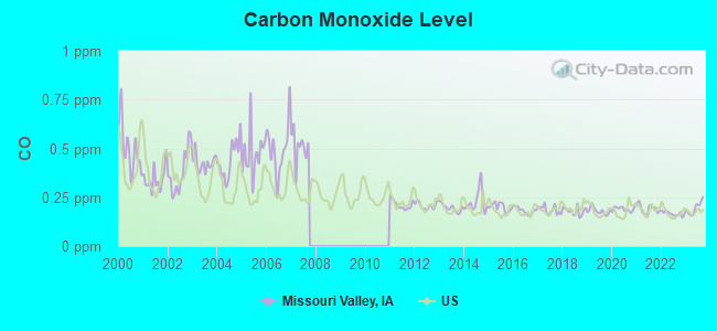
Carbon Monoxide (CO) [ppm] level in 2023 was 0.195. This is better than average. Closest monitor was 17.8 miles away from the city center.
| City: | 0.195 |
| U.S.: | 0.251 |
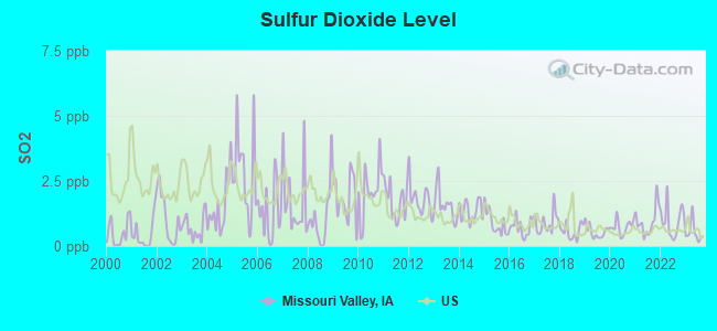
Sulfur Dioxide (SO2) [ppb] level in 2023 was 0.523. This is significantly better than average. Closest monitor was 15.3 miles away from the city center.
| City: | 0.523 |
| U.S.: | 1.515 |
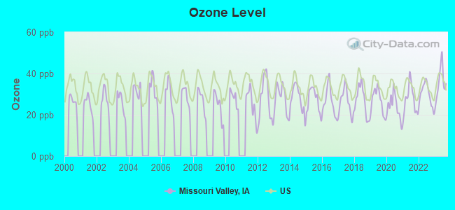
Ozone [ppb] level in 2023 was 35.5. This is about average. Closest monitor was 15.3 miles away from the city center.
| City: | 35.5 |
| U.S.: | 33.3 |
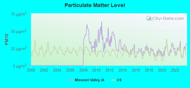
Particulate Matter (PM10) [µg/m3] level in 2023 was 21.9. This is about average. Closest monitor was 19.9 miles away from the city center.
| City: | 21.9 |
| U.S.: | 19.2 |
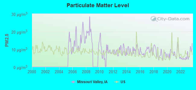
Particulate Matter (PM2.5) [µg/m3] level in 2023 was 8.35. This is about average. Closest monitor was 13.1 miles away from the city center.
| City: | 8.35 |
| U.S.: | 8.11 |
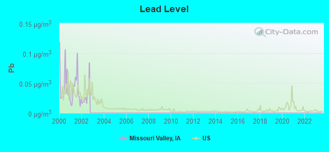
Lead (Pb) [µg/m3] level in 2002 was 0.0298. This is significantly worse than average. Closest monitor was 20.5 miles away from the city center.
| City: | 0.0298 |
| U.S.: | 0.0093 |
Tornado activity:
Missouri Valley-area historical tornado activity is near Iowa state average. It is 83% greater than the overall U.S. average.
On 6/26/1976, a category F4 (max. wind speeds 207-260 mph) tornado 17.0 miles away from the Missouri Valley city center injured 6 people and caused between $500,000 and $5,000,000 in damages.
On 5/6/1975, a category F4 tornado 20.4 miles away from the city center killed 3 people and injured 133 people and caused between $50,000 and $500,000 in damages.
Earthquake activity:
Missouri Valley-area historical earthquake activity is significantly above Iowa state average. It is 289% greater than the overall U.S. average.On 9/3/2016 at 12:02:44, a magnitude 5.8 (5.8 MW, Depth: 3.5 mi, Class: Moderate, Intensity: VI - VII) earthquake occurred 359.4 miles away from the city center
On 11/6/2011 at 03:53:10, a magnitude 5.7 (5.7 MW, Depth: 3.2 mi) earthquake occurred 419.5 miles away from Missouri Valley center
On 11/3/2002 at 20:41:56, a magnitude 4.3 (4.3 MB, Depth: 3.1 mi, Class: Light, Intensity: IV - V) earthquake occurred 175.2 miles away from Missouri Valley center
On 6/22/2019 at 08:50:24, a magnitude 4.6 (4.6 MW, Depth: 1.9 mi) earthquake occurred 246.7 miles away from Missouri Valley center
On 3/4/1983 at 06:32:18, a magnitude 4.6 (4.4 MB, 4.6 LG, 4.4 ML) earthquake occurred 255.8 miles away from the city center
On 11/12/2014 at 21:40:00, a magnitude 4.9 (4.9 MW, Depth: 2.5 mi) earthquake occurred 310.6 miles away from Missouri Valley center
Magnitude types: regional Lg-wave magnitude (LG), body-wave magnitude (MB), local magnitude (ML), moment magnitude (MW)
Natural disasters:
The number of natural disasters in Harrison County (19) is greater than the US average (15).Major Disasters (Presidential) Declared: 16
Emergencies Declared: 2
Causes of natural disasters: Floods: 14, Storms: 9, Tornadoes: 4, Winter Storms: 2, Hurricane: 1, Snow: 1, Snowstorm: 1, Other: 1 (Note: some incidents may be assigned to more than one category).
Hospitals and medical centers in Missouri Valley:
- ALEGENT HEALTH COMMUNITY MEMORIAL HOSPITAL (Voluntary non-profit - Private, provides emergency services, 631 N 8TH ST)
- LONGVIEW HOME, INC (1010 LONGVIEW ROAD)
Other hospitals and medical centers near Missouri Valley:
- WEL HOME HEALTH OF LOGAN (Home Health Center, about 8 miles away; LOGAN, IA)
- WESTMONT CARE CENTER (Nursing Home, about 8 miles away; LOGAN, IA)
- MEMORIAL COMMUNITY HOSPITAL Critical Access Hospitals (about 14 miles away; BLAIR, NE)
- CROWELL MEMORIAL HOME (Nursing Home, about 14 miles away; BLAIR, NE)
- GOOD SHEPHERD LUTHERAN HOME (Nursing Home, about 14 miles away; BLAIR, NE)
- ROSE VISTA HOME, INC. (Nursing Home, about 16 miles away; WOODBINE, IA)
Airports located in Missouri Valley:
- Missouri Valley Airport (90IA) (Runways: 1, Itinerant Ops: 730, Local Ops: 730)
Operable nuclear power plant near Missouri Valley:
- 10 miles: Fort Calhoun in Fort Calhoun, NE.
Colleges/universities with over 2000 students nearest to Missouri Valley:
- Metropolitan Community College Area (about 18 miles; Omaha, NE; Full-time enrollment: 12,236)
- Iowa Western Community College (about 21 miles; Council Bluffs, IA; FT enrollment: 5,344)
- Creighton University (about 21 miles; Omaha, NE; FT enrollment: 5,370)
- University of Nebraska Medical Center (about 22 miles; Omaha, NE; FT enrollment: 2,815)
- University of Nebraska at Omaha (about 22 miles; Omaha, NE; FT enrollment: 12,073)
- Bellevue University (about 29 miles; Bellevue, NE; FT enrollment: 7,139)
- Nebraska Wesleyan University (about 64 miles; Lincoln, NE; FT enrollment: 2,072)
Public high school in Missouri Valley:
- MISSOURI VALLEY HIGH SCHOOL (Students: 300, Location: 605 E LINCOLN HIGHWAY, Grades: 9-12)
Public elementary/middle schools in Missouri Valley:
- MISSOURI VALLEY ELEMENTARY (Students: 369, Location: 602 NORTH 9TH STREET, Grades: PK-5)
- MISSOURI VALLEY MIDDLE SCHOOL (Students: 221, Location: 607 E LINCOLN HIGHWAY, Grades: 6-8)
Points of interest:
Notable locations in Missouri Valley: United Western Co-op Elevator (A), Missouri Valley Grain Incorporated Elevator (B), Harrison County Fairground (C), Missouri Valley (D), Missouri Valley Fire Department (E), Missouri Valley Police Dapartment (F), Missouri Valley Library (G). Display/hide their locations on the map
Churches in Missouri Valley include: Christ Community Fellowship (A), Reorganized Church of Jesus Christ of Latter Day Saints (B), Church of Christ (C), Saint Paul Lutheran Church (D), First Presbyterian Church (E), First Baptist Church (F), Saint Patricks Church (G), Church of the Nazarene (H), First Lutheran Church (I). Display/hide their locations on the map
Cemeteries: Rose Hill Cemetery (1), Mount Carmel Cemetery (2). Display/hide their locations on the map
Hotels: Hillside Cottages (975 Sunnyside Avenue), Days Inn (1967 Highway 30), Super 8 Motel (3167 Joliet Avenue), RATH E J Inc (206 East Erie Street).
Court: Kovar Court (100 North 6th).
Birthplace of: Margarita Fischer - Film actor, Hugh A. Butler - Politician.
Drinking water stations with addresses in Missouri Valley and their reported violations in the past:
WILSON ISLAND STATE REC AREA (Address: 32801 CAMPGROUND LANE , Population served: 60, Groundwater):Past health violations:Past monitoring violations:
- MCL, Monthly (TCR) - In SEP-2007, Contaminant: Coliform. Follow-up actions: St Violation/Reminder Notice (SEP-11-2007), St Public Notif requested (SEP-14-2007), St Formal NOV issued (SEP-14-2007), St Public Notif received (OCT-03-2007), St Compliance achieved (APR-01-2008)
- MCL, Monthly (TCR) - In AUG-2007, Contaminant: Coliform. Follow-up actions: St Violation/Reminder Notice (AUG-17-2007), St Public Notif requested (AUG-23-2007), St Formal NOV issued (AUG-23-2007), St Public Notif received (SEP-12-2007), St Compliance achieved (APR-01-2008)
- One routine major monitoring violation
| This city: | 2.4 people |
| Iowa: | 2.4 people |
| This city: | 60.9% |
| Whole state: | 64.7% |
| This city: | 8.4% |
| Whole state: | 6.7% |
Likely homosexual households (counted as self-reported same-sex unmarried-partner households)
- Lesbian couples: 0.3% of all households
- Gay men: 0.0% of all households
121 people in nursing homes in 2000
Banks with branches in Missouri Valley (2011 data):
- American National Bank: Missouri Valley Temp Branch at 410 Lincoln Highway, branch established on 2011/06/13; Missouri Valley Branch at 304 West Erie Street, branch established on 1979/05/14. Info updated 2012/02/13: Bank assets: $1,928.1 mil, Deposits: $1,460.0 mil, headquarters in Omaha, NE, positive income, Commercial Lending Specialization, 34 total offices, Holding Company: American National Corporation
- Midstates Bank, National Association: Missouri Valley Branch at 321 East Erie Street, branch established on 1884/05/21. Info updated 2006/11/03: Bank assets: $335.1 mil, Deposits: $230.4 mil, headquarters in Council Bluffs, IA, positive income, Agricultural Specialization, 6 total offices, Holding Company: Midstates Bancshares, Inc.
- Great Western Bank: 205 E Erie Branch at 205 E Erie, branch established on 1998/12/18. Info updated 2010/06/08: Bank assets: $8,458.0 mil, Deposits: $6,362.5 mil, headquarters in Watertown, SD, positive income, Commercial Lending Specialization, 187 total offices, Holding Company: National Australia Bank Limited
For population 15 years and over in Missouri Valley:
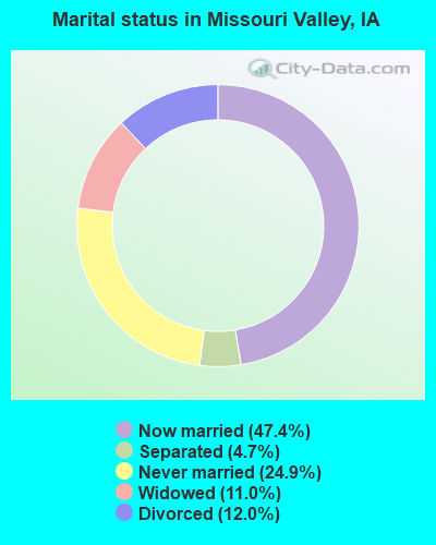
- Never married: 24.9%
- Now married: 47.4%
- Separated: 4.7%
- Widowed: 11.0%
- Divorced: 12.0%
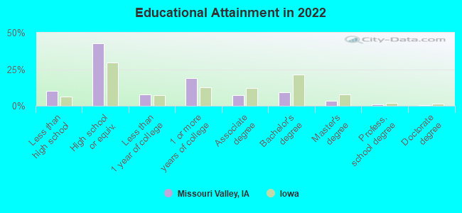
For population 25 years and over in Missouri Valley:
- High school or higher: 90.0%
- Bachelor's degree or higher: 13.0%
- Graduate or professional degree: 4.7%
- Unemployed: 4.2%
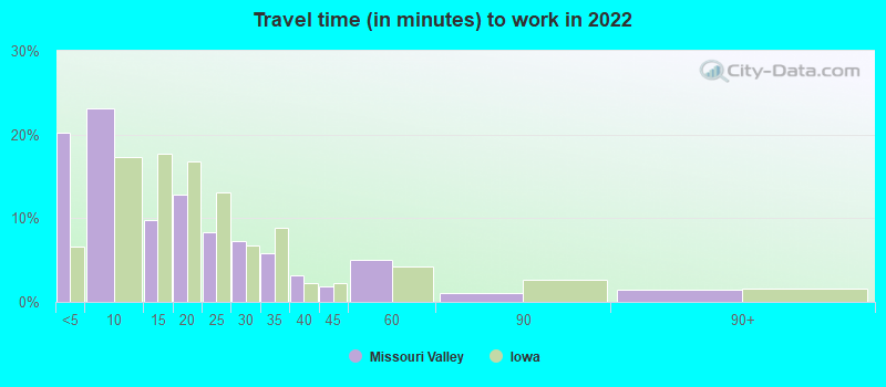
- Mean travel time to work (commute): 22.4 minutes
| Here: | 7.8 |
| Iowa average: | 10.5 |
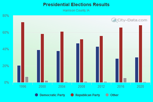
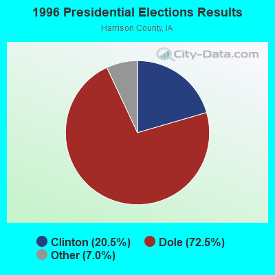
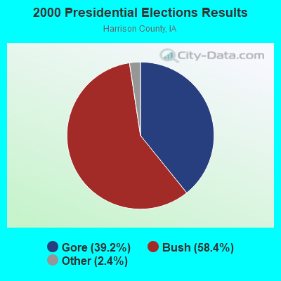
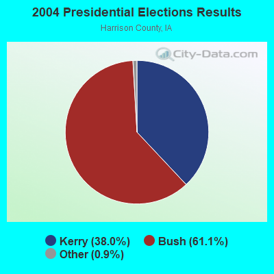

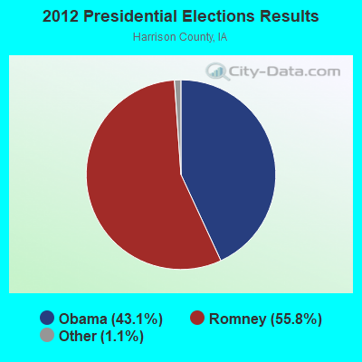
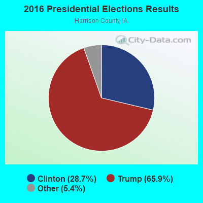
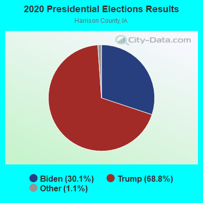
Graphs represent county-level data. Detailed 2008 Election Results
Political contributions by individuals in Missouri Valley, IA
Religion statistics for Missouri Valley, IA (based on Harrison County data)
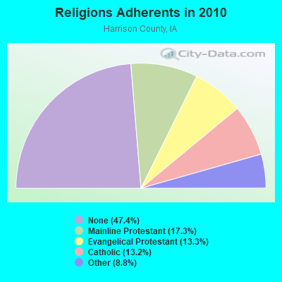
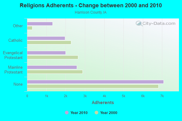
| Religion | Adherents | Congregations |
|---|---|---|
| Mainline Protestant | 2,577 | 16 |
| Evangelical Protestant | 1,988 | 13 |
| Catholic | 1,969 | 5 |
| Other | 1,316 | 6 |
| None | 7,078 | - |
Food Environment Statistics:
| Harrison County: | 1.95 / 10,000 pop. |
| Iowa: | 2.14 / 10,000 pop. |
| Here: | 0.65 / 10,000 pop. |
| Iowa: | 0.43 / 10,000 pop. |
| This county: | 9.09 / 10,000 pop. |
| Iowa: | 5.55 / 10,000 pop. |
| This county: | 5.19 / 10,000 pop. |
| Iowa: | 8.01 / 10,000 pop. |
| Harrison County: | 7.8% |
| Iowa: | 7.8% |
| Harrison County: | 28.0% |
| Iowa: | 27.3% |
| Harrison County: | 17.3% |
| Iowa: | 14.5% |
Health and Nutrition:
| This city: | 51.8% |
| Iowa: | 49.5% |
| Missouri Valley: | 49.8% |
| Iowa: | 46.1% |
| Missouri Valley: | 28.9 |
| Iowa: | 28.6 |
| Missouri Valley: | 19.7% |
| Iowa: | 21.4% |
| Here: | 10.8% |
| State: | 10.4% |
| This city: | 6.9 |
| State: | 6.8 |
| Missouri Valley: | 35.8% |
| Iowa: | 33.8% |
| This city: | 58.4% |
| State: | 55.9% |
| Missouri Valley: | 78.1% |
| Iowa: | 77.7% |
More about Health and Nutrition of Missouri Valley, IA Residents
| Local government employment and payroll (March 2022) | |||||
| Function | Full-time employees | Monthly full-time payroll | Average yearly full-time wage | Part-time employees | Monthly part-time payroll |
|---|---|---|---|---|---|
| Police Protection - Officers | 5 | $25,306 | $60,734 | 1 | $791 |
| Financial Administration | 4 | $16,339 | $49,017 | 0 | $0 |
| Parks and Recreation | 2 | $7,893 | $47,358 | 0 | $0 |
| Local Libraries | 2 | $6,955 | $41,730 | 1 | $160 |
| Streets and Highways | 2 | $8,066 | $48,396 | 0 | $0 |
| Firefighters | 0 | $0 | 7 | $582 | |
| Housing and Community Development (Local) | 0 | $0 | 1 | $2,325 | |
| Other Government Administration | 0 | $0 | 6 | $637 | |
| Totals for Government | 15 | $64,559 | $51,647 | 16 | $4,494 |
Missouri Valley government finances - Expenditure in 2017 (per resident):
- Construction - General - Other: $7,000 ($2.61)
- Current Operations - Police Protection: $619,000 ($231.23)
Regular Highways: $610,000 ($227.87)
Water Utilities: $548,000 ($204.71)
Parks and Recreation: $351,000 ($131.12)
Sewerage: $258,000 ($96.38)
Natural Resources - Other: $200,000 ($74.71)
Financial Administration: $200,000 ($74.71)
Libraries: $192,000 ($71.72)
Local Fire Protection: $171,000 ($63.88)
General - Other: $146,000 ($54.54)
Solid Waste Management: $92,000 ($34.37)
Health - Other: $79,000 ($29.51)
General Public Buildings: $55,000 ($20.55)
Protective Inspection and Regulation - Other: $22,000 ($8.22)
Miscellaneous Commercial Activities - Other: $16,000 ($5.98)
Central Staff Services: $7,000 ($2.61)
Judicial and Legal Services: $7,000 ($2.61)
- General - Interest on Debt: $138,000 ($51.55)
- Total Salaries and Wages: $924,000 ($345.16)
- Water Utilities - Interest on Debt: $126,000 ($47.07)
Missouri Valley government finances - Revenue in 2017 (per resident):
- Charges - Sewerage: $359,000 ($134.11)
Other: $135,000 ($50.43)
Solid Waste Management: $71,000 ($26.52)
Parks and Recreation: $44,000 ($16.44)
- Federal Intergovernmental - Housing and Community Development: $79,000 ($29.51)
Other: $21,000 ($7.84)
General Local Government Support: $3,000 ($1.12)
- Local Intergovernmental - Other: $123,000 ($45.95)
- Miscellaneous - General Revenue - Other: $158,000 ($59.02)
Fines and Forfeits: $33,000 ($12.33)
Interest Earnings: $27,000 ($10.09)
Sale of Property: $22,000 ($8.22)
Rents: $22,000 ($8.22)
- Revenue - Water Utilities: $576,000 ($215.17)
- State Intergovernmental - Highways: $352,000 ($131.49)
Other: $5,000 ($1.87)
- Tax - Property: $1,633,000 ($610.01)
General Sales and Gross Receipts: $211,000 ($78.82)
Other Selective Sales: $67,000 ($25.03)
Public Utilities Sales: $47,000 ($17.56)
Missouri Valley government finances - Debt in 2017 (per resident):
- Long Term Debt - Beginning Outstanding - Unspecified Public Purpose: $6,580,000 ($2457.98)
Outstanding Unspecified Public Purpose: $6,239,000 ($2330.59)
Retired Unspecified Public Purpose: $341,000 ($127.38)
Missouri Valley government finances - Cash and Securities in 2017 (per resident):
- Other Funds - Cash and Securities: $931,000 ($347.78)
- Sinking Funds - Cash and Securities: $508,000 ($189.76)
| Businesses in Missouri Valley, IA | ||||
| Name | Count | Name | Count | |
|---|---|---|---|---|
| Ace Hardware | 1 | H&R Block | 1 | |
| Arby's | 1 | McDonald's | 1 | |
| Burger King | 1 | Pizza Hut | 1 | |
| Chevrolet | 1 | Subway | 1 | |
| Days Inn | 1 | Super 8 | 1 | |
| FedEx | 1 | U-Haul | 1 | |
Strongest AM radio stations in Missouri Valley:
- KKAR (1290 AM; 50 kW; OMAHA, NE; Owner: WAITT RADIO, INC.)
- KYDZ (1180 AM; 25 kW; BELLEVUE, NE; Owner: WAITT RADIO, INC.)
- KFAB (1110 AM; 50 kW; OMAHA, NE; Owner: CAPSTAR TX LIMITED PARTNERSHIP)
- KOIL (1020 AM; 50 kW; PLATTSMOUTH, NE; Owner: WAITT RADIO, INC.)
- KOMJ (590 AM; 5 kW; OMAHA, NE; Owner: JOURNAL BROADCAST CORPORATION)
- KLNG (1560 AM; daytime; 10 kW; COUNCIL BLUFFS, IA)
- KOZN (1620 AM; 10 kW; BELLEVUE, NE; Owner: WAITT RADIO, INC.)
- KCRO (660 AM; 1 kW; OMAHA, NE; Owner: ETERNAL BROADCASTING, LLC)
- KTIC (840 AM; daytime; 5 kW; WEST POINT, NE; Owner: WEST POINT BROADCASTING, INC.)
- WHO (1040 AM; 50 kW; DES MOINES, IA; Owner: CITICASTERS LICENSES, L.P.)
- WHB (810 AM; 50 kW; KANSAS CITY, MO; Owner: UNION BROADCASTING, INC.)
- KRVN (880 AM; 50 kW; LEXINGTON, NE; Owner: NEBRASKA RURAL RADIO ASSOCIATION)
- KMA (960 AM; 5 kW; SHENANDOAH, IA; Owner: KMA BROADCASTING L.P.)
Strongest FM radio stations in Missouri Valley:
- KMLV (88.1 FM; RALSTON, NE; Owner: EDUCATIONAL MEDIA FOUNDATION)
- KGOR (99.9 FM; OMAHA, NE; Owner: CAPSTAR TX LIMITED PARTNERSHIP)
- KEZO-FM (92.3 FM; OMAHA, NE; Owner: JOURNAL BROADCAST CORPORATION)
- KQKQ-FM (98.5 FM; COUNCIL BLUFFS, IA; Owner: WAITT RADIO, INC.)
- KQCH (94.1 FM; OMAHA, NE; Owner: JOURNAL BROADCAST CORPORATION)
- KIWR (89.7 FM; COUNCIL BLUFFS, IA; Owner: IOWA WESTERN COMMUNITY COLLEGE)
- KSRZ (104.5 FM; OMAHA, NE; Owner: JOURNAL BROADCAST CORPORATION)
- KXKT (103.7 FM; GLENWOOD, IA; Owner: CAPSTAR TX LIMITED PARTNERSHIP)
- KKYY (101.3 FM; WHITING, IA; Owner: WMMP, LLC)
- KVNO (90.7 FM; OMAHA, NE; Owner: THE BOARD OF REGENTS OF UNIV. OF NEBRASKA)
- KEFM (96.1 FM; OMAHA, NE; Owner: WEBSTER COMMUNICATIONS CO.)
- KRQC (93.3 FM; BENNINGTON, NE; Owner: CAPSTAR TX LIMITED PARTNERSHIP)
- KIOS-FM (91.5 FM; OMAHA, NE; Owner: DOUGLAS COUNTY SCHOOL DISTRICT 001)
- KKCD (105.9 FM; OMAHA, NE; Owner: JOURNAL BROADCAST CORPORATION)
- KVSS (88.9 FM; OMAHA, NE; Owner: VSS CATHOLIC COMMUNICATIONS, INC.)
- KLTQ (101.9 FM; LINCOLN, NE; Owner: WAITT RADIO, INC.)
- KGBI-FM (100.7 FM; OMAHA, NE; Owner: GRACE UNIVERSITY)
- K299AK (107.7 FM; OMAHA, NE; Owner: BAER COMMUNICATIONS, INC.)
- KZSR (102.3 FM; ONAWA, IA; Owner: WMMP, LLC)
- KBLR-FM (97.3 FM; BLAIR, NE; Owner: WAITT RADIO, INC.)
TV broadcast stations around Missouri Valley:
- KMTV (Channel 3; OMAHA, NE; Owner: EMMIS TELEVISION LICENSE CORPORATION)
- KETV (Channel 7; OMAHA, NE; Owner: KETV HEARST-ARGYLE TELEVISION, INC.)
- KYNE-TV (Channel 26; OMAHA, NE; Owner: NEBRASKA EDUCATIONAL TELECOMMUNICATIONS COMM.)
- WOWT-TV (Channel 6; OMAHA, NE; Owner: GRAY MIDAMERICA TV LICENSEE CORP.)
- KVSS-LP (Channel 67; OMAHA, NE; Owner: VSS CATHOLIC COMMUNICATIONS)
- KPTM (Channel 42; OMAHA, NE; Owner: PAPPAS TELECASTING OF THE MIDLANDS)
- KXVO (Channel 15; OMAHA, NE; Owner: MITTS TELECASTING COMPANY)
- KUON-TV (Channel 12; LINCOLN, NE; Owner: THE UNIVERSITY OF NEBRASKA)
- KHIN (Channel 36; RED OAK, IA; Owner: IOWA PUBLIC BROADCASTING BOARD)
- K21ES (Channel 21; COLUMBUS, ETC, NE; Owner: DAVID C. BRODAHL)
- K61GA (Channel 61; OMAHA, NE; Owner: THREE ANGELS BROADCASTING NETWORK)
- K54EU (Channel 54; COLUMBUS-FREMONT, NE; Owner: GLENDA R. HARDERS)
- KKAZ-CA (Channel 24; OMAHA, NE; Owner: PAPPAS TELECASTING OF THE MIDLANDS)
- KOHA-LP (Channel 65; OMAHA, NE; Owner: K. SANDOVAL BURKE)
- National Bridge Inventory (NBI) Statistics
- 26Number of bridges
- 308ft / 94.3mTotal length
- 74,175Total average daily traffic
- 13,379Total average daily truck traffic
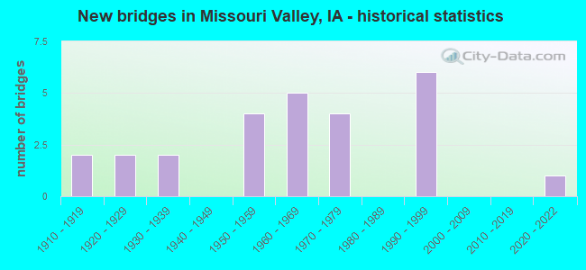
- New bridges - historical statistics
- 21910-1919
- 21920-1929
- 21930-1939
- 41950-1959
- 51960-1969
- 41970-1979
- 61990-1999
- 12020-2022
FCC Registered Cell Phone Towers:
1 (See the full list of FCC Registered Cell Phone Towers in Missouri Valley)FCC Registered Antenna Towers:
46 (See the full list of FCC Registered Antenna Towers)FCC Registered Private Land Mobile Towers:
1 (See the full list of FCC Registered Private Land Mobile Towers in Missouri Valley, IA)FCC Registered Broadcast Land Mobile Towers:
13 (See the full list of FCC Registered Broadcast Land Mobile Towers)FCC Registered Microwave Towers:
33 (See the full list of FCC Registered Microwave Towers in this town)FCC Registered Paging Towers:
1 (See the full list of FCC Registered Paging Towers)FCC Registered Amateur Radio Licenses:
29 (See the full list of FCC Registered Amateur Radio Licenses in Missouri Valley)FAA Registered Aircraft:
3- Aircraft: CESSNA 150H (Category: Land, Seats: 2, Weight: Up to 12,499 Pounds, Speed: 90 mph), Engine: CONT MOTOR 0-200 SERIES (100 HP) (Reciprocating)
N-Number: 7007S, N7007S, N-7007S, Serial Number: 15067707, Year manufactured: 1967, Airworthiness Date: 10/28/1967, Certificate Issue Date: 11/12/1992
Registrant (Individual): Mark A Wehrli, 32970 200th St, Missouri Valley, IA 51555 - Aircraft: CESSNA 182N (Category: Land, Seats: 4, Weight: Up to 12,499 Pounds, Speed: 119 mph), Engine: CONT MOTOR O-470 SERIES (230 HP) (Reciprocating)
N-Number: 9045G, N9045G, N-9045G, Serial Number: 18260585, Year manufactured: 1971, Airworthiness Date: 03/03/1971, Certificate Issue Date: 05/03/2005
Registrant (Individual): Robert L Trustee Ehmen, 2323 Ann St, Missouri Valley, IA 51555 - Aircraft: GRUMMAN ACFT ENG COR-SCHWEIZER G-164A (Category: Land, Weight: Up to 12,499 Pounds, Speed: 81 mph), Engine: P&W R1340 SERIES (600 HP) (Reciprocating)
N-Number: 8930H, N8930H, N-8930H, Serial Number: 1565, Year manufactured: 1975, Airworthiness Date: 02/03/1976, Certificate Issue Date: 07/23/2011
Registrant (Corporation): Heartland Aerial Sprayers LLC, Missouri Valley Airport / Po Box 123, Missouri Valley, IA 51555
Deregistered: Cancel Date: 10/31/2017
2003 - 2018 National Fire Incident Reporting System (NFIRS) incidents
- Fire incident types reported to NFIRS in Missouri Valley, IA
- 18747.0%Outside Fires
- 12330.9%Structure Fires
- 5714.3%Mobile Property/Vehicle Fires
- 317.8%Other
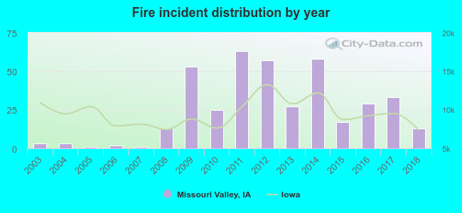 Based on the data from the years 2003 - 2018 the average number of fire incidents per year is 25. The highest number of fire incidents - 63 took place in 2011, and the least - 1 in 2005. The data has an increasing trend.
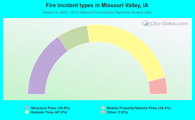 When looking into fire subcategories, the most reports belonged to: Outside Fires (47.0%), and Structure Fires (30.9%).
Fire-safe hotels and motels in Missouri Valley, Iowa:
- Oak Tree Inn, 128 S Willow, Missouri Valley, Iowa 51555 , Phone: (712) 642-3000, Fax: (712) 642-3520
- Americas Best Value Inn, 3167 Joliet Ave, Missouri valley, Iowa 51555 , Phone: (712) 642-4788, Fax: (712) 642-4200
| Most common first names in Missouri Valley, IA among deceased individuals | ||
| Name | Count | Lived (average) |
|---|---|---|
| Mary | 43 | 79.7 years |
| John | 40 | 74.9 years |
| William | 34 | 75.8 years |
| James | 30 | 74.7 years |
| Robert | 29 | 71.6 years |
| Charles | 29 | 78.7 years |
| Helen | 27 | 83.6 years |
| George | 22 | 79.9 years |
| Donald | 18 | 70.7 years |
| Harold | 16 | 74.1 years |
| Most common last names in Missouri Valley, IA among deceased individuals | ||
| Last name | Count | Lived (average) |
|---|---|---|
| Smith | 24 | 74.4 years |
| Johnson | 18 | 78.5 years |
| Jones | 15 | 80.9 years |
| Wohlers | 14 | 76.8 years |
| Thompson | 12 | 70.9 years |
| Anderson | 11 | 73.5 years |
| Nelson | 11 | 81.5 years |
| Purcell | 11 | 76.4 years |
| Brown | 11 | 82.2 years |
| Peterson | 10 | 83.3 years |
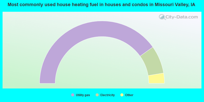
- 80.5%Utility gas
- 14.5%Electricity
- 3.8%Bottled, tank, or LP gas
- 0.7%Wood
- 0.6%No fuel used
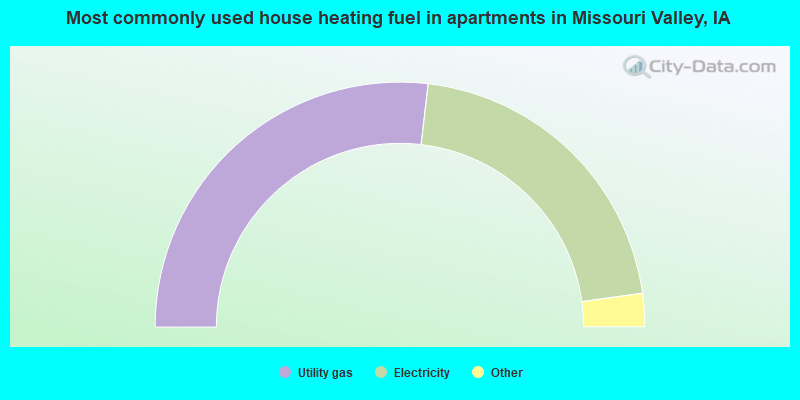
- 53.8%Utility gas
- 42.0%Electricity
- 1.4%Bottled, tank, or LP gas
- 1.4%Fuel oil, kerosene, etc.
- 1.2%Other fuel
Missouri Valley compared to Iowa state average:
- Unemployed percentage significantly below state average.
- Black race population percentage significantly below state average.
- Hispanic race population percentage significantly below state average.
- Median age below state average.
- Foreign-born population percentage significantly below state average.
- House age above state average.
- Institutionalized population percentage above state average.
- Number of college students below state average.
- Percentage of population with a bachelor's degree or higher below state average.

|
Total of 14 patent applications in 2008-2024.