Bridge Statistics for Missouri Valley, Iowa (IA)
Condition, Traffic, Stress, Structural Evaluation, Project Costs
- National Bridge Inventory (NBI) Statistics
- 26Number of bridges
- 308ft / 94.3mTotal length
- 74,175Total average daily traffic
- 13,379Total average daily truck traffic
- National Bridge Inventory (NBI) Registered Bridges for Missouri Valley
- No street view available for this location
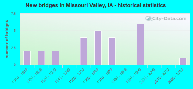
- New bridges - historical statistics
- 21910-1919
- 21920-1929
- 21930-1939
- 41950-1959
- 51960-1969
- 41970-1979
- 61990-1999
- 12020-2022

- Reconstructed bridges - Historical Statistics
- 11950-1959
- 21960-1969
- 21970-1979


- Bridge Condition - Deck
- 4.8%Excellent
- 28.6%Good
- 47.6%Satisfactory
- 14.3%Fair
- 4.8%Poor

- Bridge Condition - Superstructure
- 4.8%Excellent
- 4.8%Very good
- 28.6%Good
- 33.3%Satisfactory
- 23.8%Fair
- 4.8%Poor

- Bridge Condition - Substructure
- 4.8%Excellent
- 9.5%Very good
- 19.0%Good
- 23.8%Satisfactory
- 23.8%Fair
- 9.5%Poor
- 9.5%Serious

- Bridge Condition - Channel
- 4.8%Excellent
- 9.5%Good
- 42.9%Satisfactory
- 33.3%Fair
- 9.5%Serious

- Bridge Condition - Culverts
- 50.0%Satisfactory
- 50.0%Fair
Find on map >> Show street view
Structure Number: 8311, Location: 000000000 (Lat: 41.557333, Lng: -95.903039), Route carried "on" structure: City street , Year Built: 1996, Status: Open, Structure Length: 4.05m (13.29ft), Average Daily Traffic: 1,000 (year 2004), Average Future Daily Traffic: 1,000 (year 2041), Design Load: HS 20, Features Intersected: WILLOW RIVER, Facility Carried by Structure: HURON ST
Minimum Vertical Clearance: 30+ m (98+ ft), Kilometerpoint: 0.715, Lanes on structure: 2, Owner: City or Municipal Highway Agency, Approaching Roadway Width: 13.7m (44.9ft), Material/Design: Concrete continuous, Design/Construction: Slab, Number Of Spans In Main Unit: 3, Length of Maximum Span: 15.5m (50.9ft), Curb or Sidewalk Widths: Left: 2.7m (8.9ft), Right: 0.0m, Curb-To-Curb Width: 8.5m (27.9ft), Out-to-Out Width: 12.2m (40.0ft)
Condition: Deck: Good, Superstructure: Good, Substructure: Satisfactory, Channel: Satisfactory, Operating Rating: 69.7 metric tons, Method Used To Determine Operating Rating: Load Factor (LF), Inventory Rating: 41.7 metric tons, Method Used To Determine Inventory Rating: Load Factor (LF), Structural Evaluation: Equal to present minimum criteria, Deck Geometry: Somewhat better than minimum adequacy, Waterway Adequacy: Equal to present desirable criteria, Approach Roadway Alignment: Equal to present minimum criteria, Designated Inspection Frequency: Every 24 months, Inspection Date: August 2021, Deck Structure Type: Concrete Cast-file-Place, Wearing Surface/Protective System: Wearing Surface: Monolithic Concrete, Deck Protection: Epoxy Coated Reinforcing
Find on map >> Show street view
Structure Number: 2736, Location: 1.8 MI. W OF JCT I-29 (Lat: 41.550103, Lng: -95.952786), Route carried "on" structure: US 30, Year Built: 1953, Status: Open, Structure Length: 6.04m (19.82ft), Average Daily Traffic: 3,980 (year 2020), Truck Traffic: 28%, Average Future Daily Traffic: 3,980 (year 2041), Design Load: H 20, Features Intersected: WILSON DITCH
Minimum Vertical Clearance: 30+ m (98+ ft), Kilometerpoint: 11.932, Lanes on structure: 2, Base Highway Network: Yes, Owner: State Highway Agency, Approaching Roadway Width: 13.4m (44.0ft), Material/Design: Concrete continuous, Design/Construction: Slab, Number Of Spans In Main Unit: 5, Length of Maximum Span: 12.8m (42.0ft), Curb-To-Curb Width: 8.5m (27.9ft), Out-to-Out Width: 10.6m (34.8ft)
Condition: Deck: Fair, Superstructure: Fair, Substructure: Fair, Channel: Satisfactory, Operating Rating: 46.5 metric tons, Method Used To Determine Operating Rating: Load Factor (LF), Inventory Rating: 27.9 metric tons, Method Used To Determine Inventory Rating: Load Factor (LF), Structural Evaluation: Somewhat better than minimum adequacy, Deck Geometry: Meets minimum limits, Waterway Adequacy: Equal to present minimum criteria, Approach Roadway Alignment: Equal to present desirable criteria, Designated Inspection Frequency: Every 24 months, Inspection Date: December 2021, Deck Structure Type: Concrete Cast-file-Place, Wearing Surface/Protective System: Wearing Surface: Low Slump Concrete
Find on map >> Show street view
Structure Number: 2737, Location: 0.9 MI. W OF JCT.29 (Lat: 41.550033, Lng: -95.929142), Route carried "on" structure: US 30, Year Built: 1966, Status: Open, Structure Length: 2.23m (7.32ft), Average Daily Traffic: 5,800 (year 2020), Truck Traffic: 19%, Average Future Daily Traffic: 5,800 (year 2040), Design Load: HS 20, Features Intersected: ALLEN CREEK
Minimum Vertical Clearance: 30+ m (98+ ft), Kilometerpoint: 13.903, Lanes on structure: 2, Base Highway Network: Yes, Owner: State Highway Agency, Approaching Roadway Width: 12.2m (40.0ft), Material/Design: Concrete continuous, Design/Construction: Slab, Number Of Spans In Main Unit: 3, Length of Maximum Span: 8.2m (26.9ft), Curb or Sidewalk Widths: Left: 0.5m (1.6ft), Right: 0.5m (1.6ft), Curb-To-Curb Width: 9.1m (29.9ft), Out-to-Out Width: 10.8m (35.4ft)
Condition: Deck: Satisfactory, Superstructure: Satisfactory, Substructure: Good, Channel: Satisfactory, Operating Rating: 41.3 metric tons, Method Used To Determine Operating Rating: Allowable Stress (AS), Inventory Rating: 23.3 metric tons, Method Used To Determine Inventory Rating: Allowable Stress (AS), Structural Evaluation: Somewhat better than minimum adequacy, Deck Geometry: High priority of corrective action, Waterway Adequacy: Equal to present minimum criteria, Approach Roadway Alignment: Equal to present desirable criteria, Designated Inspection Frequency: Every 24 months, Inspection Date: April 2020, Deck Structure Type: Concrete Cast-file-Place, Wearing Surface/Protective System: Wearing Surface: Monolithic Concrete
Find on map >> Show street view
Structure Number: 27401, Location: 0.6 MI. E OF JCT. I-29 (Lat: 41.556336, Lng: -95.903106), Route carried "on" structure: US 30, Year Built: 1972, Status: Open, Structure Length: 4.05m (13.29ft), Average Daily Traffic: 9,400 (year 2020), Truck Traffic: 12%, Average Future Daily Traffic: 9,400 (year 2040), Design Load: HS 20, Features Intersected: WILLOW CREEK
Minimum Vertical Clearance: 30+ m (98+ ft), Kilometerpoint: 16.390, Lanes on structure: 2, Base Highway Network: Yes, Owner: State Highway Agency, Approaching Roadway Width: 12.2m (40.0ft), Material/Design: Concrete continuous, Design/Construction: Slab, Number Of Spans In Main Unit: 3, Length of Maximum Span: 15.5m (50.9ft), Curb or Sidewalk Widths: Left: 1.7m (5.6ft), Right: 0.2m (0.7ft), Curb-To-Curb Width: 16.5m (54.1ft), Out-to-Out Width: 19.1m (62.7ft)
Condition: Deck: Satisfactory, Superstructure: Satisfactory, Substructure: Satisfactory, Channel: Fair, Operating Rating: 57.0 metric tons, Method Used To Determine Operating Rating: Load Factor (LF), Inventory Rating: 34.2 metric tons, Method Used To Determine Inventory Rating: Load Factor (LF), Structural Evaluation: Equal to present minimum criteria, Deck Geometry: Superior to present desirable criteria, Waterway Adequacy: Better than present minimum criteria, Approach Roadway Alignment: Somewhat better than minimum adequacy, Designated Inspection Frequency: Every 24 months, Inspection Date: June 2020, Deck Structure Type: Concrete Cast-file-Place, Wearing Surface/Protective System: Wearing Surface: Monolithic Concrete
Find on map >> Show street view
Structure Number: 2741, Location: 0.8 mi. E of Jct. SR F-58 (Lat: 41.584658, Lng: -95.845167), Route carried "on" structure: US 30, Year Built: 1919, Year Reconstructed: 1956, Status: Open, Structure Length: 1.31m (4.30ft), Average Daily Traffic: 6,100 (year 2020), Truck Traffic: 18%, Average Future Daily Traffic: 6,100 (year 2041), Design Load: H 15, Features Intersected: STREAM
Minimum Vertical Clearance: 30+ m (98+ ft), Kilometerpoint: 22.822, Lanes on structure: 2, Base Highway Network: Yes, Owner: State Highway Agency, Approaching Roadway Width: 14.0m (45.9ft), Skew: 2 degrees, Material/Design: Steel, Design/Construction: Stringer/Multi-beam, Number Of Spans In Main Unit: 1, Length of Maximum Span: 11.6m (38.1ft), Curb-To-Curb Width: 9.1m (29.9ft), Out-to-Out Width: 10.6m (34.8ft)
Condition: Deck: Satisfactory, Superstructure: Satisfactory, Substructure: Satisfactory, Channel: Good, Operating Rating: 33.2 metric tons, Method Used To Determine Operating Rating: Allowable Stress (AS), Inventory Rating: 18.0 metric tons, Method Used To Determine Inventory Rating: Allowable Stress (AS), Structural Evaluation: Meets minimum limits, Deck Geometry: High priority of corrective action, Waterway Adequacy: Equal to present minimum criteria, Approach Roadway Alignment: Equal to present desirable criteria, Designated Inspection Frequency: Every 24 months, Inspection Date: July 2021, Deck Structure Type: Concrete Cast-file-Place, Wearing Surface/Protective System: Wearing Surface: Low Slump Concrete
Find on map >> Show street view
Structure Number: 27791, Location: 078442710 (Lat: 41.529939, Lng: -95.884544), Route carried "on" structure: County highway , Year Built: 1976, Status: Open, Structure Length: 2.23m (7.32ft), Average Daily Traffic: 1,070 (year 2016), Truck Traffic: 11%, Average Future Daily Traffic: 1,070 (year 2040), Design Load: HS 20, Features Intersected: DRAINAGE DITCH, Facility Carried by Structure: L20 LOESS HILLS
Minimum Vertical Clearance: 30+ m (98+ ft), Kilometerpoint: 2.673, Lanes on structure: 2, Owner: County Highway Agency, Approaching Roadway Width: 13.4m (44.0ft), Material/Design: Concrete continuous, Design/Construction: Slab, Number Of Spans In Main Unit: 3, Length of Maximum Span: 8.5m (27.9ft), Curb-To-Curb Width: 10.9m (35.8ft), Out-to-Out Width: 12.0m (39.4ft)
Condition: Deck: Satisfactory, Superstructure: Satisfactory, Substructure: Good, Channel: Satisfactory, Operating Rating: 46.2 metric tons, Method Used To Determine Operating Rating: Load Factor (LF), Inventory Rating: 27.8 metric tons, Method Used To Determine Inventory Rating: Load Factor (LF), Structural Evaluation: Equal to present minimum criteria, Deck Geometry: Equal to present minimum criteria, Waterway Adequacy: Better than present minimum criteria, Approach Roadway Alignment: Equal to present desirable criteria, Designated Inspection Frequency: Every 24 months, Inspection Date: January 2020, Deck Structure Type: Concrete Cast-file-Place, Wearing Surface/Protective System: Wearing Surface: Monolithic Concrete, Deck Protection: Epoxy Coated Reinforcing
Find on map >> Show street view
Structure Number: 27801, Location: 078442210 (Lat: 41.536325, Lng: -95.885033), Route carried "on" structure: County highway , Year Built: 1991, Status: Open, Structure Length: 8.96m (29.40ft), Average Daily Traffic: 1,070 (year 2016), Truck Traffic: 11%, Average Future Daily Traffic: 1,070 (year 2040), Design Load: HS 20, Features Intersected: BOYER RIVER, Facility Carried by Structure: L20 LOESS HILLS
Minimum Vertical Clearance: 30+ m (98+ ft), Kilometerpoint: 3.392, Lanes on structure: 2, Owner: County Highway Agency, Approaching Roadway Width: 13.4m (44.0ft), Skew: 3 degrees, Material/Design: Steel continuous, Design/Construction: Stringer/Multi-beam, Number Of Spans In Main Unit: 3, Length of Maximum Span: 36.3m (119.1ft), Curb-To-Curb Width: 11.0m (36.1ft), Out-to-Out Width: 11.9m (39.0ft)
Condition: Deck: Satisfactory, Superstructure: Good, Substructure: Good, Channel: Satisfactory, Operating Rating: 60.2 metric tons, Method Used To Determine Operating Rating: Load Factor (LF), Inventory Rating: 36.1 metric tons, Method Used To Determine Inventory Rating: Load Factor (LF), Structural Evaluation: Better than present minimum criteria, Deck Geometry: Equal to present minimum criteria, Waterway Adequacy: Equal to present desirable criteria, Approach Roadway Alignment: Equal to present desirable criteria, Designated Inspection Frequency: Every 24 months, Inspection Date: January 2020, Deck Structure Type: Concrete Cast-file-Place, Wearing Surface/Protective System: Wearing Surface: Monolithic Concrete, Deck Protection: Epoxy Coated Reinforcing
Find on map >> Show street view
Structure Number: 27811, Location: 078442204 (Lat: 41.542628, Lng: -95.887986), Route carried "on" structure: County highway , Year Built: 1991, Status: Open, Structure Length: 2.26m (7.41ft), Average Daily Traffic: 1,070 (year 2016), Truck Traffic: 11%, Average Future Daily Traffic: 1,070 (year 2040), Design Load: HS 20, Features Intersected: DRAINAGE DITCH, Facility Carried by Structure: L20 LOESS HILLS
Minimum Vertical Clearance: 30+ m (98+ ft), Kilometerpoint: 4.134, Lanes on structure: 2, Owner: County Highway Agency, Approaching Roadway Width: 12.2m (40.0ft), Skew: 3 degrees, Material/Design: Concrete continuous, Design/Construction: Slab, Number Of Spans In Main Unit: 3, Length of Maximum Span: 8.5m (27.9ft), Curb-To-Curb Width: 11.0m (36.1ft), Out-to-Out Width: 11.9m (39.0ft)
Condition: Deck: Good, Superstructure: Good, Substructure: Good, Channel: Good, Operating Rating: 68.9 metric tons, Method Used To Determine Operating Rating: Load Factor (LF), Inventory Rating: 41.4 metric tons, Method Used To Determine Inventory Rating: Load Factor (LF), Structural Evaluation: Better than present minimum criteria, Deck Geometry: Equal to present minimum criteria, Waterway Adequacy: Equal to present minimum criteria, Approach Roadway Alignment: Equal to present desirable criteria, Designated Inspection Frequency: Every 48 months, Inspection Date: January 2020, Deck Structure Type: Concrete Cast-file-Place, Wearing Surface/Protective System: Wearing Surface: Monolithic Concrete, Deck Protection: Epoxy Coated Reinforcing
Find on map >> Show street view
Structure Number: 2782, Location: 078441010 (Lat: 41.568117, Lng: -95.896789), Route carried "on" structure: City street , Year Built: 1927, Status: Open, Structure Length: 0.64m (2.10ft), Average Daily Traffic: 1,540 (year 2016), Average Future Daily Traffic: 1,540 (year 2040), Design Load: HS 20, Features Intersected: SMALL NATURAL STREAM, Facility Carried by Structure: L20 LOESS HILLS
Minimum Vertical Clearance: 30+ m (98+ ft), Kilometerpoint: 1.316, Lanes on structure: 2, Owner: County Highway Agency, Approaching Roadway Width: 10.4m (34.1ft), Material/Design: Concrete continuous, Design/Construction: Culvert, Number Of Spans In Main Unit: 2, Length of Maximum Span: 3.0m (9.8ft)
Condition: Channel: Fair, Culverts: Satisfactory, Operating Rating: 44.4 metric tons, Method Used To Determine Operating Rating: Field evaluation and documented engineering judgment, Inventory Rating: 32.7 metric tons, Method Used To Determine Inventory Rating: Field evaluation and documented engineering judgment, Structural Evaluation: Equal to present minimum criteria, Waterway Adequacy: Equal to present minimum criteria, Approach Roadway Alignment: Equal to present desirable criteria, Designated Inspection Frequency: Every 24 months, Inspection Date: January 2020
Find on map >> Show street view
Structure Number: 2783, Location: 078440306 (Lat: 41.595289, Lng: -95.896147), Route carried "on" structure: County highway , Year Built: 1926, Status: Open, Structure Length: 0.64m (2.10ft), Average Daily Traffic: 1,540 (year 2016), Truck Traffic: 11%, Average Future Daily Traffic: 1,540 (year 2039), Design Load: H 20, Features Intersected: SMALL NATURAL STREAM, Facility Carried by Structure: L20 LOESS HILLS
Minimum Vertical Clearance: 30+ m (98+ ft), Kilometerpoint: 7.973, Lanes on structure: 2, Owner: County Highway Agency, Approaching Roadway Width: 10.4m (34.1ft), Material/Design: Concrete continuous, Design/Construction: Culvert, Number Of Spans In Main Unit: 2, Length of Maximum Span: 3.0m (9.8ft)
Condition: Channel: Fair, Culverts: Fair, Operating Rating: 44.4 metric tons, Method Used To Determine Operating Rating: Field evaluation and documented engineering judgment, Inventory Rating: 32.7 metric tons, Method Used To Determine Inventory Rating: Field evaluation and documented engineering judgment, Structural Evaluation: Somewhat better than minimum adequacy, Waterway Adequacy: Somewhat better than minimum adequacy, Approach Roadway Alignment: Better than present minimum criteria, Designated Inspection Frequency: Every 24 months, Inspection Date: December 2019
Find on map >> Show street view
Structure Number: 27841, Location: 079433016 (Lat: 41.624119, Lng: -95.895758), Route carried "on" structure: County highway , Year Built: 1993, Status: Open, Structure Length: 12.37m (40.58ft), Average Daily Traffic: 1,420 (year 2016), Truck Traffic: 16%, Average Future Daily Traffic: 1,420 (year 2040), Design Load: HS 20, Features Intersected: WILLOW CREEK, Facility Carried by Structure: L20 LOESS HILLS
Minimum Vertical Clearance: 30+ m (98+ ft), Kilometerpoint: 11.182, Lanes on structure: 2, Owner: County Highway Agency, Approaching Roadway Width: 12.8m (42.0ft), Skew: 4 degrees, Material/Design: Steel continuous, Design/Construction: Stringer/Multi-beam, Number Of Spans In Main Unit: 3, Length of Maximum Span: 47.5m (155.8ft), Curb-To-Curb Width: 11.0m (36.1ft), Out-to-Out Width: 11.9m (39.0ft)
Condition: Deck: Good, Superstructure: Good, Substructure: Very good, Channel: Satisfactory, Operating Rating: 44.4 metric tons, Method Used To Determine Operating Rating: Allowable Stress (AS), Inventory Rating: 32.7 metric tons, Method Used To Determine Inventory Rating: Allowable Stress (AS), Structural Evaluation: Better than present minimum criteria, Deck Geometry: Equal to present minimum criteria, Waterway Adequacy: Equal to present desirable criteria, Approach Roadway Alignment: Equal to present desirable criteria, Designated Inspection Frequency: Every 24 months, Inspection Date: December 2020, Deck Structure Type: Concrete Cast-file-Place, Wearing Surface/Protective System: Wearing Surface: Monolithic Concrete, Deck Protection: Epoxy Coated Reinforcing
Find on map >> Show street view
Structure Number: 281, Location: AT JCT. US 30 (Lat: 41.549650, Lng: -95.917344), Route carried "on" structure: Interstate 29, Year Built: 1967, Status: Open, Structure Length: 6.77m (22.21ft), Average Daily Traffic: 6,750 (year 2020), Truck Traffic: 26%, Average Future Daily Traffic: 6,750 (year 2041), Design Load: HS 20, Features Intersected: US 30
Minimum Vertical Clearance: 30+ m (98+ ft), Kilometerpoint: 122.104, Lanes on structure: 2, Lanes under structure: 4, Base Highway Network: Yes, Owner: State Highway Agency, Approaching Roadway Width: 12.2m (40.0ft), Material/Design: Prestressed concrete, Design/Construction: Stringer/Multi-beam, Number Of Spans In Main Unit: 4, Length of Maximum Span: 21.0m (68.9ft), Curb-To-Curb Width: 11.9m (39.0ft), Out-to-Out Width: 12.9m (42.3ft)
Condition: Deck: Good, Superstructure: Satisfactory, Substructure: Satisfactory, Operating Rating: 82.4 metric tons, Method Used To Determine Operating Rating: Load Factor (LF), Inventory Rating: 35.3 metric tons, Method Used To Determine Inventory Rating: Load Factor (LF), Structural Evaluation: Equal to present minimum criteria, Deck Geometry: Equal to present minimum criteria, Underclear: Equal to present minimum criteria, Approach Roadway Alignment: Better than present minimum criteria, Designated Inspection Frequency: Every 24 months, Inspection Date: September 2021, Deck Structure Type: Concrete Cast-file-Place, Wearing Surface/Protective System: Wearing Surface: Low Slump Concrete
Find on map >> Show street view
Structure Number: 17765, Location: 078440401 (Lat: 41.603022, Lng: -95.902981), Route carried "on" structure: County highway , Year Built: 1930, Year Reconstructed: 1974, Status: Posted for load, Structure Length: 2.19m (7.19ft), Average Daily Traffic: 60 (year 2016), Average Future Daily Traffic: 60 (year 2039), Design Load: HS 20, Features Intersected: WILLOW RIVER, Facility Carried by Structure: LOCAL 280TH ST
Minimum Vertical Clearance: 30+ m (98+ ft), Kilometerpoint: 14.996, Lanes on structure: 2, Owner: County Highway Agency, Approaching Roadway Width: 7.6m (24.9ft), Material/Design: Steel, Design/Construction: Truss - Thru, Number Of Spans In Main Unit: 1, Length of Maximum Span: 21.3m (69.9ft), Curb-To-Curb Width: 6.8m (22.3ft), Out-to-Out Width: 6.8m (22.3ft)
Condition: Deck: Poor, Superstructure: Poor, Substructure: Serious, Channel: Serious, Operating Rating: 18.5 metric tons, Method Used To Determine Operating Rating: Load Factor (LF), Inventory Rating: 11.1 metric tons, Method Used To Determine Inventory Rating: Load Factor (LF), Structural Evaluation: High priority of corrective action, Deck Geometry: Somewhat better than minimum adequacy, Waterway Adequacy: Equal to present minimum criteria, Approach Roadway Alignment: Equal to present minimum criteria, Bridge Posting: Required (Relationship of Operating Rating to Maximum Legal Load: > 39.9% below), Length Of Structure Improvement: 9.80m (32.15ft), Designated Inspection Frequency: Every 24 months, Critical Feature Inspection Frequency: Every 24 months, Inspection Date: December 2019, Critical Feature Inspection Date: December 2019, Bridge Improvement Cost: $147,000, Roadway Improvement Cost: $15,000, Deck Structure Type: Corrugated Steel, Wearing Surface/Protective System: Wearing Surface: Bituminous
Find on map >> Show street view
Structure Number: 177672, Location: 078440501 (Lat: 41.603236, Lng: -95.935031), Route carried "on" structure: County highway , Year Built: 2020, Status: Open, Structure Length: 2.44m (8.01ft), Average Daily Traffic: 45 (year 2016), Average Future Daily Traffic: 45 (year 2040), Design Load: HL 93, Features Intersected: ALLEN CREEK, Facility Carried by Structure: 280TH STREET
Minimum Vertical Clearance: 30+ m (98+ ft), Kilometerpoint: 12.326, Lanes on structure: 2, Owner: County Highway Agency, Approaching Roadway Width: 9.1m (29.9ft), Material/Design: Concrete continuous, Design/Construction: Slab, Number Of Spans In Main Unit: 3, Length of Maximum Span: 9.4m (30.8ft), Curb-To-Curb Width: 7.5m (24.6ft), Out-to-Out Width: 8.3m (27.2ft)
Condition: Deck: Excellent, Superstructure: Excellent, Substructure: Excellent, Channel: Excellent, Operating Rating: 48.6 metric tons, Method Used To Determine Operating Rating: Load and Resistance Factor Rating (LRFR) rating reported by rating factor(RF) method using HL-93 loadings, Inventory Rating: 37.3 metric tons, Method Used To Determine Inventory Rating: Load and Resistance Factor Rating (LRFR) rating reported by rating factor(RF) method using HL-93 loadings, Structural Evaluation: Superior to present desirable criteria, Deck Geometry: Equal to present minimum criteria, Waterway Adequacy: Superior to present desirable criteria, Approach Roadway Alignment: Superior to present desirable criteria, Designated Inspection Frequency: Every 24 months, Inspection Date: January 2020, Deck Structure Type: Concrete Cast-file-Place, Wearing Surface/Protective System: Wearing Surface: Integral Concrete, Deck Protection: Epoxy Coated Reinforcing
Find on map >> Show street view
Structure Number: 177701, Location: 078441203 (Lat: 41.573492, Lng: -95.845567), Route carried "on" structure: County highway , Year Built: 1974, Status: Open, Structure Length: 7.71m (25.30ft), Average Daily Traffic: 580 (year 2016), Truck Traffic: 16%, Average Future Daily Traffic: 580 (year 2040), Design Load: HS 20, Features Intersected: BOYER RIVER, Facility Carried by Structure: 296TH ST
Minimum Vertical Clearance: 30+ m (98+ ft), Kilometerpoint: 0.496, Lanes on structure: 2, Owner: County Highway Agency, Approaching Roadway Width: 11.6m (38.1ft), Material/Design: Steel continuous, Design/Construction: Stringer/Multi-beam, Number Of Spans In Main Unit: 3, Length of Maximum Span: 29.9m (98.1ft), Curb or Sidewalk Widths: Left: 0.3m (1.0ft), Right: 0.3m (1.0ft), Curb-To-Curb Width: 9.1m (29.9ft), Out-to-Out Width: 9.8m (32.2ft)
Condition: Deck: Satisfactory, Superstructure: Good, Substructure: Fair, Channel: Satisfactory, Operating Rating: 47.8 metric tons, Method Used To Determine Operating Rating: Allowable Stress (AS), Inventory Rating: 30.4 metric tons, Method Used To Determine Inventory Rating: Allowable Stress (AS), Structural Evaluation: Somewhat better than minimum adequacy, Deck Geometry: Equal to present minimum criteria, Waterway Adequacy: Better than present minimum criteria, Approach Roadway Alignment: Equal to present desirable criteria, Length Of Structure Improvement: 32.90m (107.94ft), Designated Inspection Frequency: Every 24 months, Inspection Date: January 2020, Bridge Improvement Cost: $494,000, Roadway Improvement Cost: $50,000, Deck Structure Type: Concrete Cast-file-Place, Wearing Surface/Protective System: Wearing Surface: Monolithic Concrete
Find on map >> Show street view
Structure Number: 177711, Location: 078441701 (Lat: 41.564692, Lng: -95.928742), Route carried "on" structure: County highway , Year Built: 1974, Status: Open, Structure Length: 2.01m (6.59ft), Average Daily Traffic: 140 (year 2016), Average Future Daily Traffic: 140 (year 2039), Design Load: HS 20, Features Intersected: ALLEN CREEK, Facility Carried by Structure: 305TH ST
Minimum Vertical Clearance: 30+ m (98+ ft), Kilometerpoint: 9.481, Lanes on structure: 2, Owner: County Highway Agency, Approaching Roadway Width: 7.6m (24.9ft), Material/Design: Steel, Design/Construction: Girder and Floorbeam System, Number Of Spans In Main Unit: 1, Length of Maximum Span: 19.8m (65.0ft), Curb-To-Curb Width: 7.3m (24.0ft), Out-to-Out Width: 7.3m (24.0ft)
Condition: Deck: Good, Superstructure: Fair, Substructure: Fair, Channel: Satisfactory, Operating Rating: 35.9 metric tons, Method Used To Determine Operating Rating: Load Factor (LF), Inventory Rating: 25.9 metric tons, Method Used To Determine Inventory Rating: Load Factor (LF), Structural Evaluation: Somewhat better than minimum adequacy, Deck Geometry: Somewhat better than minimum adequacy, Waterway Adequacy: Better than present minimum criteria, Approach Roadway Alignment: Somewhat better than minimum adequacy, Length Of Structure Improvement: 9.00m (29.53ft), Designated Inspection Frequency: Every 24 months, Critical Feature Inspection Frequency: Every 24 months, Inspection Date: December 2019, Critical Feature Inspection Date: December 2019, Bridge Improvement Cost: $134,000, Roadway Improvement Cost: $14,000, Deck Structure Type: Corrugated Steel, Wearing Surface/Protective System: Wearing Surface: Gravel
Find on map >> Show street view
Structure Number: 17772, Location: 078442103 (Lat: 41.549900, Lng: -95.903039), Route carried "on" structure: County highway , Year Built: 1916, Year Reconstructed: 1967, Status: Posted for load, Structure Length: 3.35m (10.99ft), Average Daily Traffic: 100 (year 2016), Average Future Daily Traffic: 100 (year 2040), Design Load: HS 20, Features Intersected: WILLOW RIVER, Facility Carried by Structure: LOC CANAL ST
Minimum Vertical Clearance: 30+ m (98+ ft), Kilometerpoint: 7.031, Lanes on structure: 2, Owner: County Highway Agency, Approaching Roadway Width: 8.2m (26.9ft), Material/Design: Steel, Design/Construction: Truss - Thru, Number Of Spans In Main Unit: 1, Number Of Approach Spans: 1, Length of Maximum Span: 24.4m (80.1ft), Curb-To-Curb Width: 5.4m (17.7ft), Out-to-Out Width: 5.4m (17.7ft)
Condition: Deck: Fair, Superstructure: Fair, Substructure: Serious, Channel: Fair, Operating Rating: 17.5 metric tons, Method Used To Determine Operating Rating: Allowable Stress (AS), Inventory Rating: 12.1 metric tons, Method Used To Determine Inventory Rating: Allowable Stress (AS), Structural Evaluation: High priority of corrective action, Waterway Adequacy: Equal to present minimum criteria, Approach Roadway Alignment: Meets minimum limits, Bridge Posting: Required (Relationship of Operating Rating to Maximum Legal Load: 30.0 - 39.9% below), Length Of Structure Improvement: 10.40m (34.12ft), Designated Inspection Frequency: Every 24 months, Critical Feature Inspection Frequency: Every 24 months, Inspection Date: January 2020, Critical Feature Inspection Date: January 2020, Bridge Improvement Cost: $158,000, Roadway Improvement Cost: $16,000, Deck Structure Type: Wood or Timber, Wearing Surface/Protective System: Wearing Surface: Wood or Timber
Find on map >> Show street view
Structure Number: 17773, Location: 078442301 (Lat: 41.549150, Lng: -95.872181), Route carried "on" structure: County highway , Year Built: 1959, Status: Open, Structure Length: 7.68m (25.20ft), Average Daily Traffic: 790 (year 2016), Truck Traffic: 10%, Average Future Daily Traffic: 790 (year 2040), Design Load: H 15, Features Intersected: BOYER RIVER, Facility Carried by Structure: FM 335TH ST
Minimum Vertical Clearance: 30+ m (98+ ft), Kilometerpoint: 9.617, Lanes on structure: 2, Owner: County Highway Agency, Approaching Roadway Width: 10.7m (35.1ft), Skew: 2 degrees, Material/Design: Steel continuous, Design/Construction: Stringer/Multi-beam, Number Of Spans In Main Unit: 3, Length of Maximum Span: 29.9m (98.1ft), Curb or Sidewalk Widths: Left: 0.7m (2.3ft), Right: 0.7m (2.3ft), Curb-To-Curb Width: 7.3m (24.0ft), Out-to-Out Width: 8.6m (28.2ft)
Condition: Deck: Satisfactory, Superstructure: Good, Substructure: Fair, Channel: Fair, Operating Rating: 41.3 metric tons, Method Used To Determine Operating Rating: Load Factor (LF), Inventory Rating: 24.8 metric tons, Method Used To Determine Inventory Rating: Load Factor (LF), Structural Evaluation: Somewhat better than minimum adequacy, Deck Geometry: Meets minimum limits, Waterway Adequacy: Better than present minimum criteria, Approach Roadway Alignment: Equal to present minimum criteria, Length Of Structure Improvement: 28.80m (94.49ft), Designated Inspection Frequency: Every 24 months, Inspection Date: January 2020, Bridge Improvement Cost: $431,000, Roadway Improvement Cost: $44,000, Deck Structure Type: Concrete Cast-file-Place, Wearing Surface/Protective System: Wearing Surface: Monolithic Concrete
Find on map >> Show street view
Structure Number: 17775, Location: 078442408 (Lat: 41.539069, Lng: -95.843561), Route carried "on" structure: County highway , Year Built: 1956, Status: Open, Structure Length: 1.28m (4.20ft), Average Daily Traffic: 240 (year 2016), Average Future Daily Traffic: 240 (year 2040), Design Load: HS 20, Features Intersected: SMALL CREEK, Facility Carried by Structure: LOC MUNICE AVE
Minimum Vertical Clearance: 30+ m (98+ ft), Kilometerpoint: 3.645, Lanes on structure: 2, Owner: County Highway Agency, Approaching Roadway Width: 8.5m (27.9ft), Material/Design: Concrete, Design/Construction: Channel Beam, Number Of Spans In Main Unit: 1, Length of Maximum Span: 12.2m (40.0ft), Curb-To-Curb Width: 5.9m (19.4ft), Out-to-Out Width: 6.0m (19.7ft)
Condition: Deck: Satisfactory, Superstructure: Satisfactory, Substructure: Fair, Channel: Fair, Operating Rating: 44.4 metric tons, Method Used To Determine Operating Rating: Field evaluation and documented engineering judgment, Inventory Rating: 32.7 metric tons, Method Used To Determine Inventory Rating: Field evaluation and documented engineering judgment, Structural Evaluation: Somewhat better than minimum adequacy, Deck Geometry: High priority of corrective action, Waterway Adequacy: Equal to present desirable criteria, Approach Roadway Alignment: Equal to present desirable criteria, Length Of Structure Improvement: 6.30m (20.67ft), Designated Inspection Frequency: Every 24 months, Inspection Date: January 2020, Bridge Improvement Cost: $95,000, Roadway Improvement Cost: $10,000, Deck Structure Type: Other
Find on map >> Show street view
Structure Number: 17778, Location: 078443203 (Lat: 41.520997, Lng: -95.927058), Route carried "on" structure: County highway , Year Built: 1959, Year Reconstructed: 1983, Status: Posted for load, Structure Length: 1.89m (6.20ft), Average Daily Traffic: 20 (year 2016), Average Future Daily Traffic: 20 (year 2040), Design Load: HS 20, Features Intersected: ALLEN CREEK, Facility Carried by Structure: LOC 335TH ST
Minimum Vertical Clearance: 30+ m (98+ ft), Kilometerpoint: 5.131, Lanes on structure: 2, Owner: County Highway Agency, Approaching Roadway Width: 6.1m (20.0ft), Material/Design: Steel continuous, Design/Construction: Stringer/Multi-beam, Number Of Spans In Main Unit: 2, Length of Maximum Span: 18.0m (59.1ft), Curb-To-Curb Width: 7.3m (24.0ft), Out-to-Out Width: 7.3m (24.0ft)
Condition: Deck: Fair, Superstructure: Fair, Substructure: Poor, Channel: Serious, Operating Rating: 23.7 metric tons, Method Used To Determine Operating Rating: Load Factor (LF), Inventory Rating: 14.1 metric tons, Method Used To Determine Inventory Rating: Load Factor (LF), Structural Evaluation: Meets minimum limits, Deck Geometry: Equal to present minimum criteria, Waterway Adequacy: Better than present minimum criteria, Approach Roadway Alignment: Meets minimum limits, Bridge Posting: Required (Relationship of Operating Rating to Maximum Legal Load: 10.0 - 19.9% below), Length Of Structure Improvement: 8.70m (28.54ft), Designated Inspection Frequency: Every 24 months, Inspection Date: January 2020, Bridge Improvement Cost: $130,000, Roadway Improvement Cost: $14,000, Deck Structure Type: Corrugated Steel, Wearing Surface/Protective System: Wearing Surface: Bituminous
Find on map >> Show street view
Structure Number: 178201, Location: 079433101 (Lat: 41.617561, Lng: -95.900556), Route carried "on" structure: County highway , Year Built: 1990, Status: Open, Structure Length: 3.90m (12.80ft), Average Daily Traffic: 380 (year 2016), Truck Traffic: 23%, Average Future Daily Traffic: 380 (year 2040), Design Load: HS 20, Features Intersected: WILLOW CREEK, Facility Carried by Structure: FM 270TH ST
Minimum Vertical Clearance: 30+ m (98+ ft), Kilometerpoint: 8.552, Lanes on structure: 2, Owner: County Highway Agency, Approaching Roadway Width: 10.4m (34.1ft), Skew: 1 degrees, Material/Design: Concrete continuous, Design/Construction: Slab, Number Of Spans In Main Unit: 3, Length of Maximum Span: 14.9m (48.9ft), Curb-To-Curb Width: 7.5m (24.6ft), Out-to-Out Width: 8.3m (27.2ft)
Condition: Deck: Satisfactory, Superstructure: Satisfactory, Substructure: Satisfactory, Channel: Fair, Operating Rating: 88.0 metric tons, Method Used To Determine Operating Rating: Load Factor (LF), Inventory Rating: 52.7 metric tons, Method Used To Determine Inventory Rating: Load Factor (LF), Structural Evaluation: Equal to present minimum criteria, Deck Geometry: Somewhat better than minimum adequacy, Waterway Adequacy: Equal to present minimum criteria, Approach Roadway Alignment: Equal to present desirable criteria, Designated Inspection Frequency: Every 24 months, Inspection Date: December 2020, Deck Structure Type: Concrete Cast-file-Place, Wearing Surface/Protective System: Wearing Surface: Monolithic Concrete
Find on map >> Show street view
Structure Number: 17833, Location: 079443501 (Lat: 41.617653, Lng: -95.935042), Route carried "on" structure: County highway , Year Built: 1930, Year Reconstructed: 1977, Status: Open, Structure Length: 2.93m (9.61ft), Average Daily Traffic: 380 (year 2016), Truck Traffic: 23%, Average Future Daily Traffic: 380 (year 2040), Features Intersected: ALLEN CREEK, Facility Carried by Structure: FM & 270TH ST
Minimum Vertical Clearance: 30+ m (98+ ft), Kilometerpoint: 5.678, Lanes on structure: 2, Owner: County Highway Agency, Approaching Roadway Width: 9.1m (29.9ft), Material/Design: Steel, Design/Construction: Truss - Thru, Number Of Spans In Main Unit: 1, Number Of Approach Spans: 2, Length of Maximum Span: 27.4m (89.9ft), Curb or Sidewalk Widths: Left: 0.3m (1.0ft), Right: 0.3m (1.0ft), Curb-To-Curb Width: 7.1m (23.3ft), Out-to-Out Width: 7.5m (24.6ft)
Condition: Deck: Satisfactory, Superstructure: Fair, Substructure: Poor, Channel: Satisfactory, Operating Rating: 23.9 metric tons, Method Used To Determine Operating Rating: Load Factor (LF), Inventory Rating: 17.4 metric tons, Method Used To Determine Inventory Rating: Load Factor (LF), Structural Evaluation: Meets minimum limits, Deck Geometry: Meets minimum limits, Waterway Adequacy: Better than present minimum criteria, Approach Roadway Alignment: Better than present minimum criteria, Bridge Posting: Required (Relationship of Operating Rating to Maximum Legal Load: 0.1 - 9.9% below), Length Of Structure Improvement: 12.80m (41.99ft), Designated Inspection Frequency: Every 24 months, Critical Feature Inspection Frequency: Every 24 months, Inspection Date: January 2020, Critical Feature Inspection Date: January 2020, Bridge Improvement Cost: $192,000, Roadway Improvement Cost: $20,000, Deck Structure Type: Wood or Timber, Wearing Surface/Protective System: Wearing Surface: Wood or Timber
Find on map >> Show street view
Structure Number: 60811, Location: 0.8 mi. E of Jct I-29 (Lat: 41.555056, Lng: -95.905564), Route carried "on" structure: US 30, Year Built: 1998, Status: Open, Structure Length: 7.41m (24.31ft), Average Daily Traffic: 9,400 (year 2020), Truck Traffic: 12%, Average Future Daily Traffic: 9,400 (year 2041), Design Load: HS 20+Mod, Features Intersected: UPRR
Minimum Vertical Clearance: 30+ m (98+ ft), Kilometerpoint: 16.129, Lanes on structure: 2, Base Highway Network: Yes, Owner: State Highway Agency, Approaching Roadway Width: 13.4m (44.0ft), Skew: 3 degrees, Material/Design: Steel continuous, Design/Construction: Stringer/Multi-beam, Number Of Spans In Main Unit: 3, Length of Maximum Span: 28.7m (94.2ft), Curb-To-Curb Width: 13.4m (44.0ft), Out-to-Out Width: 14.3m (46.9ft)
Condition: Deck: Good, Superstructure: Very good, Substructure: Very good, Operating Rating: 54.6 metric tons, Method Used To Determine Operating Rating: Load Factor (LF), Inventory Rating: 32.7 metric tons, Method Used To Determine Inventory Rating: Load Factor (LF), Structural Evaluation: Equal to present desirable criteria, Deck Geometry: Equal to present minimum criteria, Underclear: Superior to present desirable criteria, Approach Roadway Alignment: Equal to present minimum criteria, Designated Inspection Frequency: Every 24 months, Inspection Date: July 2021, Deck Structure Type: Concrete Cast-file-Place, Wearing Surface/Protective System: Wearing Surface: Monolithic Concrete, Deck Protection: Epoxy Coated Reinforcing
Find on map >> Show street view
Structure Number: 281, Location: AT JCT. US 30 (Lat: 41.549650, Lng: -95.917344), Route carried "under" structure: US 30, Year Built: 1967, Structure Length: 0. m, Average Daily Traffic: 3,850 (year 2020), Truck Traffic: 15%, Features Intersected: US 30, Facility Carried by Structure: I 29 NB
Minimum Vertical Clearance: 30+ m (98+ ft), Kilometerpoint: 14.888, Lanes on structure: 2, Lanes under structure: 4, Material/Design: Prestressed concrete, Design/Construction: Stringer/Multi-beam, Length of Maximum Span: 21.0m (68.9ft)
Find on map >> Show street view
Structure Number: 2811, Location: AT JCT. US 30 (Lat: 41.550211, Lng: -95.917625), Route carried "under" structure: US 30, Year Built: 1967, Structure Length: 0. m, Average Daily Traffic: 3,850 (year 2020), Truck Traffic: 15%, Features Intersected: US 30, Facility Carried by Structure: SB I-29
Minimum Vertical Clearance: 30+ m (98+ ft), Kilometerpoint: 14.862, Lanes on structure: 3, Lanes under structure: 4, Material/Design: Prestressed concrete, Design/Construction: Stringer/Multi-beam, Length of Maximum Span: 20.7m (67.9ft)
Find on map >> Show street view
Structure Number: 2814, Location: 1.0 MI. N OF JCT. US 30 (Lat: 41.564692, Lng: -95.918419), Route carried "under" structure: Interstate 29, Year Built: 1966, Structure Length: 0. m, Average Daily Traffic: 13,600 (year 2020), Truck Traffic: 28%, Features Intersected: I-29, Facility Carried by Structure: LOCAL RD
Minimum Vertical Clearance: 30+ m (98+ ft), Kilometerpoint: 123.771, Lanes on structure: 2, Lanes under structure: 4, Material/Design: Prestressed concrete, Design/Construction: Stringer/Multi-beam, Length of Maximum Span: 21.0m (68.9ft)