Malone, Florida
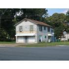
Malone: Old building , downtown Malone
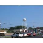
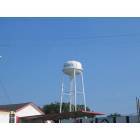
Malone: Water Tower, downtown Malone
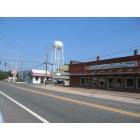
Malone: Old building and water tower, downtown Malone
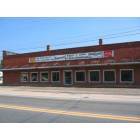
Malone: Old building , downtown Malone
Malone: Water Tower, downtown Malone
- add
your
Submit your own pictures of this town and show them to the world
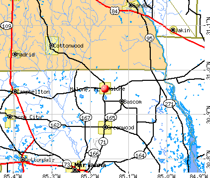
- OSM Map
- General Map
- Google Map
- MSN Map
Population change since 2000: -22.3%
 |
| Males: 1,191 | |
| Females: 368 |
| Median resident age: | 37.8 years |
| Florida median age: | 42.7 years |
Zip codes: 32445.
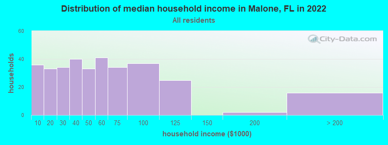
| Malone: | $46,791 |
| FL: | $69,303 |
Estimated per capita income in 2022: $9,651 (it was $5,701 in 2000)
Malone town income, earnings, and wages data
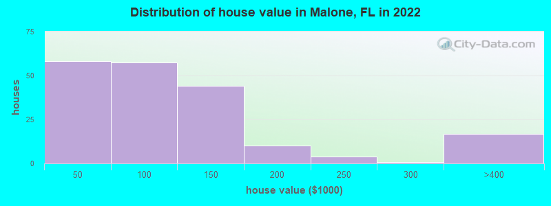
Estimated median house or condo value in 2022: $83,738 (it was $57,400 in 2000)
| Malone: | $83,738 |
| FL: | $354,100 |
Median gross rent in 2022: $765.
(26.6% for White Non-Hispanic residents, 39.3% for Black residents, 65.9% for Hispanic or Latino residents, 36.8% for other race residents, 76.2% for two or more races residents)
Detailed information about poverty and poor residents in Malone, FL
Compare current foreclosures near Malone, FL:
| Photo | Address | Area | Beds / Baths | Price | Details |
|---|---|---|---|---|---|

|
#1
Friendship Church Rd
Malone, FL 32445
|
1,344 sq. feet
|
1 baths 2 beds |
show details | |

|
#2
Avon Rd
Ashford, AL 36312
|
1,706 sq. feet
|
2 baths 3 beds |
$69,900
|
show details |

|
#3
Oak St
Cottondale, FL 32431
|
3,005 sq. feet
|
2 baths 3 beds |
show details | |

|
#4
Rill Loop
Marianna, FL 32448
|
1,217 sq. feet
|
2 baths 3 beds |
show details | |

|
#5
Gene Terry Rd
Ashford, AL 36312
|
1,627 sq. feet
|
1 baths 3 beds |
show details | |

|
#6
Waterfront Ln # 360
Jakin, GA 39861
|
1,200 sq. feet
|
2 baths 2 beds |
show details | |

|
#7
N Broadway St
Ashford, AL 36312
|
2,279 sq. feet
|
2 baths 3 beds |
show details | |

|
#8
Whaley Ct
Ashford, AL 36312
|
- sq. feet
|
2 baths 3 beds |
show details | |

|
#9
Sunset Dr
Marianna, FL 32448
|
1,269 sq. feet
|
1 baths 3 beds |
show details | |

|
#10
Vallie Rd
Marianna, FL 32446
|
2,160 sq. feet
|
2 baths 3 beds |
show details |
| Photo | Address | Area | Beds / Baths | Price | Details |
|---|---|---|---|---|---|

|
#11
S County Road 55
Ashford, AL 36312
|
1,803 sq. feet
|
2 baths 3 beds |
show details | |

|
#12
Gladys Cir
Marianna, FL 32446
|
792 sq. feet
|
3 baths 6 beds |
show details | |

|
#13
Pansey Rd
Ashford, AL 36312
|
1,025 sq. feet
|
1 baths 3 beds |
show details | |

|
#14
Boat Landing Rd
Gordon, AL 36343
|
768 sq. feet
|
1 baths 2 beds |
show details | |

|
#15
Blue Arrow Dr
Marianna, FL 32446
|
1,536 sq. feet
|
2 baths 2 beds |
show details | |

|
#16
Hilltop Rd
Ashford, AL 36312
|
897 sq. feet
|
1 baths 2 beds |
show details | |

|
#17
Swilley St
Marianna, FL 32448
|
1,000 sq. feet
|
2 baths 3 beds |
show details | |

|
#18
1st Ave
Ashford, AL 36312
|
1,204 sq. feet
|
2 baths 3 beds |
show details | |

|
#19
Todd St
Cottonwood, AL 36320
|
1,294 sq. feet
|
1 baths 3 beds |
show details | |

|
#20
Great Oaks Dr
Marianna, FL 32446
|
1,501 sq. feet
|
2 baths 3 beds |
show details |
| Photo | Address | Area | Beds / Baths | Price | Details |
|---|---|---|---|---|---|

|
#21
Todd St
Cottonwood, AL 36320
|
1,805 sq. feet
|
2 baths 3 beds |
show details | |

|
#22
Hickory Hill Dr
Marianna, FL 32446
|
1,325 sq. feet
|
2 baths 3 beds |
show details | |

|
#23
S County Road 55
Ashford, AL 36312
|
2,072 sq. feet
|
2 baths 3 beds |
show details | |

|
#24
Coot Fowler Rd
Dothan, AL 36301
|
2,815 sq. feet
|
3 baths 4 beds |
show details | |

|
#25
N County Road 33
Ashford, AL 36312
|
1,868 sq. feet
|
2 baths 3 beds |
show details | |

|
#26
S County 55 Rd
Cottonwood, AL 36320
|
2,600 sq. feet
|
2 baths 3 beds |
show details | |

|
#27
Metcalf St
Cottonwood, AL 36320
|
1,086 sq. feet
|
1 baths 2 beds |
show details | |

|
#28
E County 8 Rd
Ashford, AL 36312
|
1,200 sq. feet
|
1 baths 3 beds |
show details | |

|
#29
Marble Ct
Marianna, FL 32446
|
1,664 sq. feet
|
2 baths 3 beds |
show details | |

|
#30
South St
Marianna, FL 32448
|
1,247 sq. feet
|
1 baths 3 beds |
show details |
| Photo | Address | Area | Beds / Baths | Price | Details |
|---|---|---|---|---|---|

|
#31
Saint Mary Rd
Cottonwood, AL 36320
|
2,517 sq. feet
|
2 baths 3 beds |
show details | |

|
#32
Ed Tolar Rd
Pansey, AL 36370
|
1,386 sq. feet
|
2 baths 3 beds |
show details | |

|
#33
Nobles Rd
Cottonwood, AL 36320
|
1,092 sq. feet
|
1 baths 3 beds |
show details | |

|
#34
Cottonwood Rd
Dothan, AL 36301
|
1,288 sq. feet
|
2 baths 3 beds |
show details | |

|
#35
Dock Lamb Rd
Pansey, AL 36370
|
1,442 sq. feet
|
2 baths 3 beds |
show details | |

|
#36
Grove St
Cottonwood, AL 36320
|
1,989 sq. feet
|
1 baths 2 beds |
show details | |

|
#37
Hickory Ln
Marianna, FL 32448
|
1,025 sq. feet
|
1 baths 3 beds |
show details | |

|
#38
Cottonwood Rd
Dothan, AL 36301
|
3,210 sq. feet
|
2 baths 3 beds |
show details | |

|
#39
Fort Rd
Greenwood, FL 32443
|
2,065 sq. feet
|
1 baths 3 beds |
show details | |

|
#40
Bates Rd
Greenwood, FL 32443
|
1,680 sq. feet
|
2 baths 3 beds |
show details |
| Photo | Address | Area | Beds / Baths | Price | Details |
|---|---|---|---|---|---|

|
#41
N County Road 75
Ashford, AL 36312
|
1,380 sq. feet
|
1 baths - beds |
show details | |

|
#42
Mcdaniel Rd
Ashford, AL 36312
|
2,201 sq. feet
|
1 baths - beds |
show details | |

|
#43
Staley St
Marianna, FL 32446
|
1,140 sq. feet
|
1 baths - beds |
show details | |

|
#44
Park St
Ashford, AL 36312
|
1,438 sq. feet
|
1 baths - beds |
show details | |

|
#45
Bell Ln
Ashford, AL 36312
|
- sq. feet
|
- baths - beds |
show details | |

|
#46
Cottonwood Rd Lot 43
Dothan, AL 36301
|
- sq. feet
|
- baths - beds |
show details | |

|
#47
Harper Joy Rd
Dothan, AL 36301
|
1,248 sq. feet
|
- baths - beds |
show details | |

|
#48
Cottonwood Rd Lot 44
Dothan, AL 36301
|
- sq. feet
|
- baths - beds |
show details | |

|
#49
S State Highway 605
Slocomb, AL 36375
|
- sq. feet
|
- baths - beds |
show details | |

|
Check over 1 million property listings on Foreclosure.com!
|
browse all offers | |||


- 93942.3%White alone
- 82537.1%Black alone
- 34815.7%Hispanic
- 753.4%Two or more races
- 140.6%Asian alone
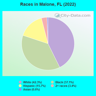
Races in Malone detailed stats: ancestries, foreign born residents, place of birth
According to our research of Florida and other state lists, there were 2 registered sex offenders living in Malone, Florida as of May 11, 2024.
The ratio of all residents to sex offenders in Malone is 1,023 to 1.
The ratio of registered sex offenders to all residents in this city is lower than the state average.
 Recent articles from our blog. Our writers, many of them Ph.D. graduates or candidates, create easy-to-read articles on a wide variety of topics.

 | Coronavirus positives in Bradenton and Hillsborough Counties (2490 replies) |
| Good Time for SoFla Sports (41 replies) |
| WHAT'S HAPPENING THIS WEEKEND! fairs, festivals, etc. (386 replies) |
| Upscale/Luxury Shopping in Florida (4 replies) |
| Best place to live in the Ft Lauderdale area? (26 replies) |
| Lookingat apartments, need Insight on safe areas (14 replies) |
Latest news from Malone, FL collected exclusively by city-data.com from local newspapers, TV, and radio stations
Ancestries: American (16.9%), Irish (6.8%), English (4.6%), African (3.0%), Haitian (2.8%), Moroccan (2.3%).
Current Local Time: CST time zone
Elevation: 138 feet
Land area: 3.13 square miles.
Population density: 498 people per square mile (low).
105 residents are foreign born (4.4% Latin America).
| This town: | 4.7% |
| Florida: | 21.1% |
| Malone town: | 0.6% ($339) |
| Florida: | 1.4% ($1,262) |
Nearest city with pop. 50,000+: Dothan, AL  (23.7 miles , pop. 57,737).
Nearest city with pop. 200,000+: Montgomery, AL (117.3 miles , pop. 201,568).
Nearest city with pop. 1,000,000+: Houston, TX (615.4 miles , pop. 1,953,631).
Nearest cities:
), )Latitude: 30.96 N, Longitude: 85.16 W
Area code: 850

| Here: | 3.8% |
| Florida: | 2.9% |
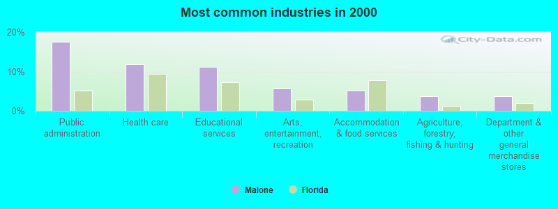
- Public administration (17.5%)
- Health care (11.8%)
- Educational services (11.1%)
- Arts, entertainment, recreation (5.7%)
- Accommodation & food services (5.1%)
- Agriculture, forestry, fishing & hunting (3.7%)
- Department & other general merchandise stores (3.7%)
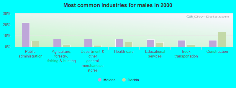
- Public administration (21.9%)
- Agriculture, forestry, fishing & hunting (7.3%)
- Department & other general merchandise stores (7.3%)
- Health care (7.3%)
- Educational services (6.6%)
- Truck transportation (6.0%)
- Construction (6.0%)
- Health care (16.4%)
- Educational services (15.8%)
- Public administration (13.0%)
- Arts, entertainment, recreation (11.6%)
- Accommodation & food services (7.5%)
- Religious, grantmaking, civic, professional, similar organizations (5.5%)
- Food & beverage stores (3.4%)
- Law enforcement workers, including supervisors (6.4%)
- Building and grounds cleaning and maintenance occupations (6.4%)
- Cashiers (5.1%)
- Secretaries and administrative assistants (4.7%)
- Health technologists and technicians (4.4%)
- Other management occupations, except farmers and farm managers (4.0%)
- Counselors, social workers, and other community and social service specialists (4.0%)
- Law enforcement workers, including supervisors (12.6%)
- Building and grounds cleaning and maintenance occupations (8.6%)
- Other management occupations, except farmers and farm managers (6.6%)
- Other sales and related occupations, including supervisors (6.0%)
- Agricultural workers, including supervisors (5.3%)
- Farmers and farm managers (5.3%)
- Driver/sales workers and truck drivers (5.3%)
- Cashiers (10.3%)
- Health technologists and technicians (8.9%)
- Other office and administrative support workers, including supervisors (7.5%)
- Secretaries and administrative assistants (7.5%)
- Textile, apparel, and furnishings workers (5.5%)
- Nursing, psychiatric, and home health aides (4.8%)
- Building and grounds cleaning and maintenance occupations (4.1%)
Average climate in Malone, Florida
Based on data reported by over 4,000 weather stations


|
|


(lower is better)

Air Quality Index (AQI) level in 2019 was 47.9. This is significantly better than average.
| City: | 47.9 |
| U.S.: | 72.6 |
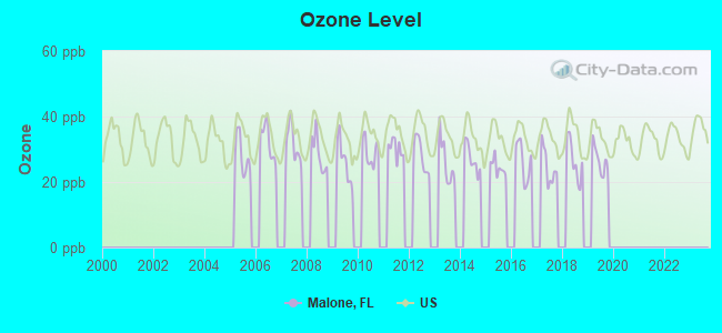
Ozone [ppb] level in 2019 was 26.7. This is better than average. Closest monitor was 22.3 miles away from the city center.
| City: | 26.7 |
| U.S.: | 33.3 |
Tornado activity:
Malone-area historical tornado activity is slightly above Florida state average. It is 47% greater than the overall U.S. average.
On 3/22/2005, a category F3 (max. wind speeds 158-206 mph) tornado 15.7 miles away from the Malone town center killed one person and injured 18 people and caused $7 million in damages.
On 12/29/1973, a category F3 tornado 29.4 miles away from the town center injured 2 people and caused between $500,000 and $5,000,000 in damages.
Earthquake activity:
Malone-area historical earthquake activity is significantly above Florida state average. It is 6% smaller than the overall U.S. average.On 10/24/1997 at 08:35:17, a magnitude 4.9 (4.8 MB, 4.2 MS, 4.9 LG, Depth: 6.2 mi, Class: Light, Intensity: IV - V) earthquake occurred 125.6 miles away from the city center
On 1/18/1999 at 07:00:53, a magnitude 4.8 (4.8 MB, 4.0 LG, Depth: 0.6 mi) earthquake occurred 209.0 miles away from Malone center
On 4/29/2003 at 08:59:39, a magnitude 4.9 (4.4 MB, 4.6 MW, 4.9 LG) earthquake occurred 246.1 miles away from the city center
On 8/2/1974 at 08:52:09, a magnitude 4.9 (4.3 MB, 4.9 LG) earthquake occurred 254.9 miles away from the city center
On 4/29/2003 at 08:59:39, a magnitude 4.6 (4.6 MW, Depth: 12.3 mi) earthquake occurred 246.1 miles away from Malone center
On 11/7/2004 at 11:20:21, a magnitude 4.3 (4.3 MW, Depth: 3.1 mi) earthquake occurred 200.6 miles away from the city center
Magnitude types: regional Lg-wave magnitude (LG), body-wave magnitude (MB), surface-wave magnitude (MS), moment magnitude (MW)
Natural disasters:
The number of natural disasters in Jackson County (19) is greater than the US average (15).Major Disasters (Presidential) Declared: 9
Emergencies Declared: 5
Causes of natural disasters: Hurricanes: 9, Tropical Storms: 4, Fires: 3, Floods: 3, Storms: 3, Tornadoes: 3, Winds: 2, Other: 1 (Note: some incidents may be assigned to more than one category).

Hospitals and medical centers near Malone:
- SUNLAND MARIANNA FACILITY IV (Hospital, about 9 miles away; MARIANNA, FL)
- SUNLAND MARIANNA FAC V (Hospital, about 9 miles away; MARIANNA, FL)
- NURSING PAVILION AT CHIPOLA RETIREMENT CENTER (Nursing Home, about 13 miles away; MARIANNA, FL)
- NHC HOMECARE MARIANNA (Home Health Center, about 14 miles away; MARIANNA, FL)
Airports located in Malone:
- Hart Airport (3FL8) (Runways: 1)
- North American Farms Airport (56FD) (Runways: 1)
Colleges/universities with over 2000 students nearest to Malone:
- George C Wallace State Community College-Dothan (about 31 miles; Dothan, AL; Full-time enrollment: 3,611)
- Bainbridge State College (about 38 miles; Bainbridge, GA; FT enrollment: 2,308)
- Enterprise State Community College (about 47 miles; Enterprise, AL; FT enrollment: 2,101)
- Tallahassee Community College (about 61 miles; Tallahassee, FL; FT enrollment: 10,904)
- Florida State University (about 63 miles; Tallahassee, FL; FT enrollment: 38,283)
- Gulf Coast State College (about 64 miles; Panama City, FL; FT enrollment: 4,474)
- Florida Agricultural and Mechanical University (about 64 miles; Tallahassee, FL; FT enrollment: 10,841)
Public high school in Malone:
- MALONE HIGH SCHOOL (Students: 310, Location: 5361 9TH ST, Grades: PK-12)
User-submitted facts and corrections:
- They have a christan Rock station 88.3 added by Tookie
Points of interest:
| This town: | 2.4 people |
| Florida: | 2.5 people |
| This town: | 61.6% |
| Whole state: | 65.2% |
| This town: | 6.2% |
| Whole state: | 7.3% |
Likely homosexual households (counted as self-reported same-sex unmarried-partner households)
- Lesbian couples: 1.4% of all households
- Gay men: 0.0% of all households
1,287 people in state prisons in 2000
Banks with branches in Malone (2011 data):
- PeoplesSouth Bank: Malone-Pcb, The Community Branch at 5408 Tenth Street, branch established on 1943/01/02. Info updated 2006/11/03: Bank assets: $534.5 mil, Deposits: $446.4 mil, headquarters in Colquitt, GA, positive income, Commercial Lending Specialization, 19 total offices, Holding Company: Peoplessouth Bancshares, Inc.
For population 15 years and over in Malone:
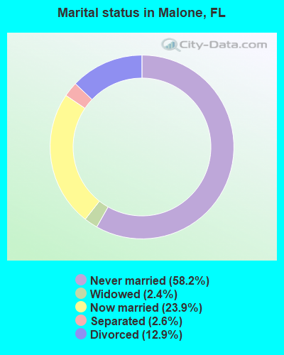
- Never married: 58.2%
- Now married: 23.9%
- Separated: 2.6%
- Widowed: 2.4%
- Divorced: 12.9%
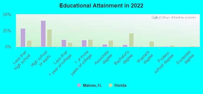
For population 25 years and over in Malone:
- High school or higher: 69.7%
- Bachelor's degree or higher: 4.8%
- Graduate or professional degree: 1.5%
- Unemployed: 7.5%
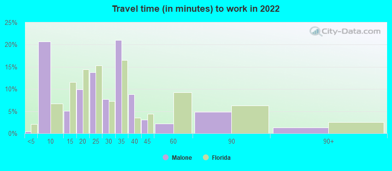
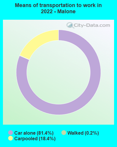
- Mean travel time to work (commute): 25.5 minutes
| Here: | 11.4 |
| Florida average: | 12.2 |
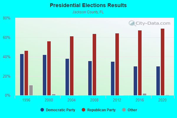
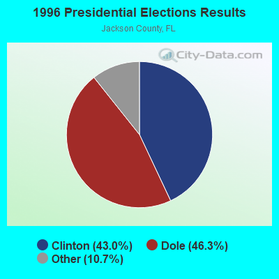
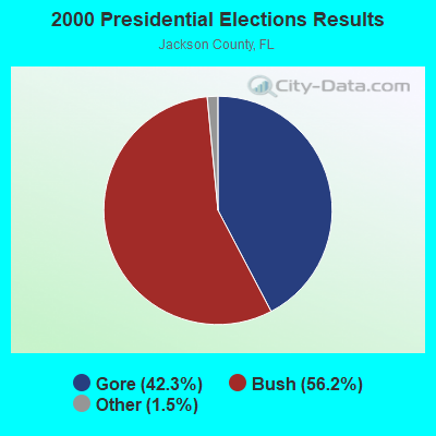
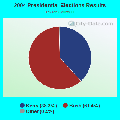

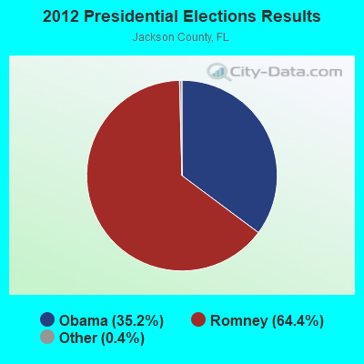
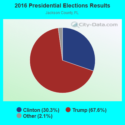
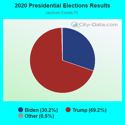
Graphs represent county-level data. Detailed 2008 Election Results
Religion statistics for Malone, FL (based on Jackson County data)
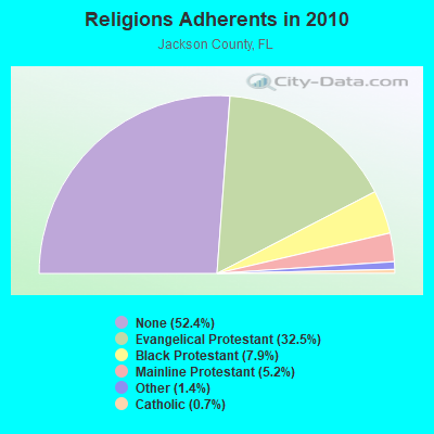

| Religion | Adherents | Congregations |
|---|---|---|
| Evangelical Protestant | 16,156 | 96 |
| Black Protestant | 3,925 | 26 |
| Mainline Protestant | 2,565 | 20 |
| Other | 675 | 2 |
| Catholic | 371 | 1 |
| None | 26,054 | - |
Food Environment Statistics:
| Jackson County: | 2.04 / 10,000 pop. |
| Florida: | 2.04 / 10,000 pop. |
| Jackson County: | 0.20 / 10,000 pop. |
| Florida: | 0.11 / 10,000 pop. |
| Jackson County: | 1.63 / 10,000 pop. |
| Florida: | 1.28 / 10,000 pop. |
| Here: | 4.88 / 10,000 pop. |
| State: | 3.04 / 10,000 pop. |
| Jackson County: | 3.46 / 10,000 pop. |
| State: | 7.45 / 10,000 pop. |
| Here: | 11.5% |
| Florida: | 9.2% |
| Jackson County: | 30.2% |
| State: | 23.7% |
| Here: | 11.9% |
| Florida: | 14.0% |
Health and Nutrition:
| This city: | 46.9% |
| Florida: | 51.4% |
| Here: | 40.7% |
| Florida: | 49.4% |
| Malone: | 28.7 |
| Florida: | 28.6 |
| Malone: | 17.9% |
| Florida: | 19.5% |
| Here: | 8.7% |
| Florida: | 10.7% |
| Malone: | 6.6 |
| Florida: | 6.9 |
| Malone: | 27.0% |
| State: | 34.7% |
| This city: | 55.0% |
| State: | 57.0% |
| Here: | 81.3% |
| State: | 79.2% |
More about Health and Nutrition of Malone, FL Residents
| Local government employment and payroll (March 2022) | |||||
| Function | Full-time employees | Monthly full-time payroll | Average yearly full-time wage | Part-time employees | Monthly part-time payroll |
|---|---|---|---|---|---|
| Other and Unallocable | 2 | $5,871 | $35,226 | 0 | $0 |
| Financial Administration | 1 | $2,303 | $27,636 | 0 | $0 |
| Other Government Administration | 0 | $0 | 7 | $1,859 | |
| Parks and Recreation | 0 | $0 | 1 | $516 | |
| Totals for Government | 3 | $8,174 | $32,696 | 8 | $2,376 |
Malone government finances - Expenditure in 2017 (per resident):
- Construction - Parks and Recreation: $5,000 ($3.21)
- Current Operations - Financial Administration: $176,000 ($112.89)
Water Utilities: $135,000 ($86.59)
Regular Highways: $109,000 ($69.92)
Solid Waste Management: $65,000 ($41.69)
Sewerage: $49,000 ($31.43)
Local Fire Protection: $26,000 ($16.68)
Parks and Recreation: $25,000 ($16.04)
Central Staff Services: $20,000 ($12.83)
- Other Capital Outlay - Regular Highways: $187,000 ($119.95)
Local Fire Protection: $14,000 ($8.98)
- Water Utilities - Interest on Debt: $18,000 ($11.55)
Malone government finances - Revenue in 2017 (per resident):
- Charges - Solid Waste Management: $77,000 ($49.39)
Sewerage: $37,000 ($23.73)
Regular Highways: $22,000 ($14.11)
Other: $5,000 ($3.21)
- Federal Intergovernmental - Other: $10,000 ($6.41)
- Local Intergovernmental - Other: $53,000 ($34.00)
- Miscellaneous - General Revenue - Other: $2,000 ($1.28)
- Revenue - Water Utilities: $116,000 ($74.41)
- State Intergovernmental - Highways: $108,000 ($69.28)
General Local Government Support: $71,000 ($45.54)
- Tax - Occupation and Business License - Other: $83,000 ($53.24)
General Sales and Gross Receipts: $56,000 ($35.92)
Public Utilities Sales: $44,000 ($28.22)
Other Selective Sales: $34,000 ($21.81)
Property: $13,000 ($8.34)
Motor Fuels Sales: $6,000 ($3.85)
Other License: $2,000 ($1.28)
Malone government finances - Debt in 2017 (per resident):
- Long Term Debt - Beginning Outstanding - Unspecified Public Purpose: $317,000 ($203.34)
Outstanding Unspecified Public Purpose: $285,000 ($182.81)
Retired Unspecified Public Purpose: $160,000 ($102.63)
Issue, Unspecified Public Purpose: $123,000 ($78.90)
Malone government finances - Cash and Securities in 2017 (per resident):
- Other Funds - Cash and Securities: $274,000 ($175.75)
- Sinking Funds - Cash and Securities: $31,000 ($19.88)
Businesses in Malone, FL
- Subway: 1
Strongest AM radio stations in Malone:
- WOOF (560 AM; 5 kW; DOTHAN, AL; Owner: WOOF, INC.)
- WTCL (1580 AM; daytime; 10 kW; CHATTAHOOCHEE, FL; Owner: METZ, INC.)
- WSTT (730 AM; 25 kW; THOMASVILLE, GA; Owner: MARION R. WILLIAMS)
- WTOT (980 AM; 1 kW; MARIANNA, FL; Owner: MFR, INC.)
- WMGR (930 AM; 5 kW; BAINBRIDGE, GA; Owner: DECATUR BROADCASTING, INC.)
- WYBT (1000 AM; daytime; 5 kW; BLOUNTSTOWN, FL; Owner: BLOUNTSTOWN COMMUNICATIONS, INC.)
- WTYS (1340 AM; 1 kW; MARIANNA, FL; Owner: JAMES L. ADAMS, JR.)
- WQLS (1200 AM; 10 kW; OZARK, AL; Owner: STYLES BROADCASTING OF DOTHAN, INC.)
- WAGF (1320 AM; 2 kW; DOTHAN, AL)
- WFVR (910 AM; 50 kW; VALDOSTA, GA; Owner: RAMA COMMUNICATIONS, INC.)
- WFRF (1070 AM; daytime; 10 kW; TALLAHASSEE, FL; Owner: FAITH RADIO NETWORK, INC.)
- WHGH (840 AM; daytime; 10 kW; THOMASVILLE, GA; Owner: H. G. H INVESTMENT CORP.)
- WMAC (940 AM; 50 kW; MACON, GA; Owner: CUMULUS LICENSING CORP.)
Strongest FM radio stations in Malone:
- WTVY-FM (95.5 FM; DOTHAN, AL; Owner: STYLES BROADCASTING OF DOTHAN, INC.)
- WOOF-FM (99.7 FM; DOTHAN, AL; Owner: WOOF, INC.)
- WDJR (96.9 FM; ENTERPRISE, AL; Owner: GULF SOUTH COMMUNICATIONS, INC.)
- WJJN (92.1 FM; COLUMBIA, AL; Owner: WILSON BROADCASTING CO., INC.)
- WRAK-FM (97.3 FM; BAINBRIDGE, GA; Owner: CLEAR CHANNEL BROADCASTING LICENSES, INC.)
- WTYS-FM (94.1 FM; MARIANNA, FL; Owner: JAMES L. ADAMS, JR.)
- WWGF (107.5 FM; DONALSONVILLE, GA; Owner: BARINOWSKI INVESTMENT COMPANY)
- WFSY (98.5 FM; PANAMA CITY, FL; Owner: CLEAR CHANNEL BROADCASTING LICENSES, INC.)
- WJAQ (100.9 FM; MARIANNA, FL; Owner: MFR, INC.)
- WJNF (91.1 FM; MARIANNA, FL; Owner: MARIANNA EDUCATIONAL BROADCASTING FOUNDATION)
- WAGF-FM (101.3 FM; DOTHAN, AL; Owner: WILSON BROADCASTING CO., INC.)
- W291AD (106.1 FM; MARIANNA, FL; Owner: FLORIDA STATE UNIVERSITY)
- WPAP-FM (92.5 FM; PANAMA CITY, FL; Owner: CLEAR CHANNEL BROADCASTING LICENSES, INC.)
- WZND (105.3 FM; HEADLAND, AL; Owner: GULF SOUTH COMMUNICATIONS, INC.)
- WYYX (97.7 FM; BONIFAY, FL; Owner: STYLES MEDIA GROUP, LLC)
- WESP (102.5 FM; DOTHAN, AL; Owner: GULF SOUTH COMMUNICATIONS, INC)
- WGMK (106.3 FM; DONALSONVILLE, GA; Owner: MERCHANTS BROADCASTING CO)
- WTOT-FM (101.7 FM; GRACEVILLE, FL; Owner: GRF, INC.)
- WVOB (91.3 FM; DOTHAN, AL; Owner: BETHANY BIBLE COLLEGE & B.T.S. INC.)
TV broadcast stations around Malone:
- WTVY (Channel 4; DOTHAN, AL; Owner: GRAY MIDAMERICA TV LICENSEE CORP.)
- WJJN-LP (Channel 5; DOTHAN, AL; Owner: JAMES WILSON, III)
- WDHN (Channel 18; DOTHAN, AL; Owner: MORRIS NETWORK OF ALABAMA, INC.)
- WTLH (Channel 49; BAINBRIDGE, GA; Owner: WTLH LICENSE CORP.)
- WBIF (Channel 51; MARIANNA, FL; Owner: MARIANNA BROADCASTING, INC.)
- WMBB (Channel 13; PANAMA CITY, FL; Owner: MEDIA GENERAL BROADCASTING OF SO. CAROLINA HOLDINGS, INC.)
- WDFX-TV (Channel 34; OZARK, AL; Owner: WAITT LICENSE CO. OF ALABAMA, L.L.C.)
- WJHG-TV (Channel 7; PANAMA CITY, FL; Owner: WJHG LICENSEE CORP.)
- W41BN (Channel 41; DOTHAN, AL; Owner: TRINITY BROADCASTING NETWORK)
- W69DO (Channel 69; COLQUITT, GA; Owner: MS COMMUNICATIONS, LLC)
FCC Registered Antenna Towers:
4- Sara Benson, Off Of Highway 71 (Lat: 30.978111 Lon: -85.173111), Type: 60.7, Structure height: 12063 m, Overall height: 59.4 m, Registrant: Skyway Towers, LLC, Operations@skywaytowers.Com, , Land -O Lakes, Phone: (813) 960-6200
- Sara Benson, Off Of Highway 71 (Lat: 30.978111 Lon: -85.173111), Type: 60.7, Structure height: 12063 m, Overall height: 59.4 m, Licensee ID: L, Registrant: Skyway Towers, LLC, Operations@skywaytowers.Com, , Land -O Lakes, Phone: (813) 960-6200
- Sara Benson, Off Of Highway 71 (Lat: 30.978111 Lon: -85.173111), Type: 60.7, Structure height: 12063 m, Overall height: 59.4 m, Registrant: Skyway Towers, LLC, Operations@skywaytowers.Com, , Land -O Lakes, Phone: (813) 960-6200
- Katrina McCarron, Off Of Highway 71 (Lat: 30.978111 Lon: -85.173111), Type: 60.7, Structure height: 12063 m, Overall height: 59.4 m, Registrant: Skyway Towers, LLC, Operations@skywaytowers.Com, , Tampa, Phone: (813) 960-6200
FCC Registered Broadcast Land Mobile Towers:
4- Hwy 71 N, City Hall (Lat: 30.957139 Lon: -85.161028), Type: Tower, Structure height: 30 m, Overall height: 33 m, Call Sign: WNJD609,
Assigned Frequencies: 151.430 MHz, Grant Date: 02/22/2003, Expiration Date: 02/04/2013, Cancellation Date: 04/08/2013, Registrant: Apco Spectrum Management Division Licensing Services 10/24/12 Cec, 351 N Williamson Blvd, Daytona Beach, FL 32114, Phone: (386) 944-2463, Fax: (386) 322-2502, Email:
- Sr 71 (Lat: 30.978528 Lon: -85.168556), Structure height: 50 m, Call Sign: WNQU545,
Assigned Frequencies: 45.1600 MHz, Grant Date: 09/04/2014, Expiration Date: 11/16/2024, Cancellation Date: 09/10/2021, Registrant: Florida Department Of Correction, 501 Sout Calhoun Street, Tallahassee, FL 32399, Phone: (850) 717-3195, Email:
- Sr 71 (Lat: 30.978528 Lon: -85.168556), Structure height: 50 m, Call Sign: WNQU462,
Assigned Frequencies: 45.4200 MHz, Grant Date: 09/04/2014, Expiration Date: 11/16/2024, Cancellation Date: 09/10/2021, Registrant: Florida Department Of Correction, 501 Sout Calhoun Street, Tallahassee, FL 32399, Phone: (850) 717-3195, Email:
- Substation At Int Ford Rd & Friendship Ch Rd (Lat: 30.937972 Lon: -85.178806), Call Sign: WNWV536, Licensee ID: L00003541,
Assigned Frequencies: 457.250 MHz, Grant Date: 05/25/2001, Expiration Date: 07/17/2011, Cancellation Date: 09/17/2011, Registrant: Powersouth Energy Cooperative, 2027 E. Three Notch Street, Andalusia, AL 36420, Phone: (334) 427-3000, Fax: (334) 427-3439, Email:
FCC Registered Microwave Towers:
1- SKYWAY MALONE, Off Of Highway 71 (Lat: 30.978111 Lon: -85.173111), Type: Mtower, Structure height: 59.4 m, Overall height: 60.7 m, Call Sign: WQUV961,
Assigned Frequencies: 5945.20 MHz, 5974.85 MHz, 6004.50 MHz, 6034.15 MHz, 6063.80 MHz, 6093.45 MHz, 6123.10 MHz, 6152.75 MHz, Grant Date: 10/29/2014, Expiration Date: 10/29/2024, Certifier: Gregory M Romano, Registrant: Verizon, 5055 Northpointe Pkwy, Alpharetta, GA 30022, Phone: (770) 797-1070, Email:
FCC Registered Amateur Radio Licenses:
6- Call Sign: KB4JVN, Licensee ID: L00926716, Grant Date: 09/03/2014, Expiration Date: 10/13/2024, Registrant: Kenneth L Campbell, 5284 10th St., Malone, FL 32445
- Call Sign: KE4SGU, Grant Date: 10/25/1994, Expiration Date: 10/25/2004, Cancellation Date: 10/26/2006, Registrant: Bonnie A Hodges, 5467 10th, Malone, FL 32445
- Call Sign: KG4SRG, Licensee ID: L00496661, Grant Date: 04/09/2002, Expiration Date: 04/09/2012, Cancellation Date: 04/10/2014, Certifier: Keefe C Hatcher, Registrant: Keefe C Hatcher, 5491 Collins Chapel Rd, Malone, FL 32445
- Call Sign: W4GQW, Previous Call Sign: W5GQW, Licensee ID: L00209105, Grant Date: 09/13/2014, Expiration Date: 09/13/2024, Certifier: Robert H Bailey, Registrant: Robert H Bailey, 5685 Friendship Church Rd., Malone, FL 32445
- Call Sign: KO4CC, Previous Call Sign: KM5OA, Licensee ID: L00209102, Grant Date: 09/13/2014, Expiration Date: 09/13/2024, Cancellation Date: 01/21/2015, Certifier: Teresa G Bailey, Registrant: Teresa G Bailey, 5685 Friendship Church Rd., Malone, FL 32445
- Call Sign: AB4TB, Previous Call Sign: KO4CC, Licensee ID: L00209102, Grant Date: 01/21/2015, Expiration Date: 01/21/2025, Certifier: Teresa G Bailey, Registrant: Teresa G Bailey, 5685 Friendship Church Rd., Malone, FL 32445
2002 - 2018 National Fire Incident Reporting System (NFIRS) incidents
- Fire incident types reported to NFIRS in Malone, FL
- 5640.0%Structure Fires
- 5136.4%Outside Fires
- 3021.4%Mobile Property/Vehicle Fires
- 32.1%Other
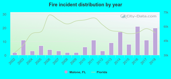 Based on the data from the years 2002 - 2018 the average number of fires per year is 8. The highest number of reported fires - 21 took place in 2016, and the least - 2 in 2002. The data has a rising trend.
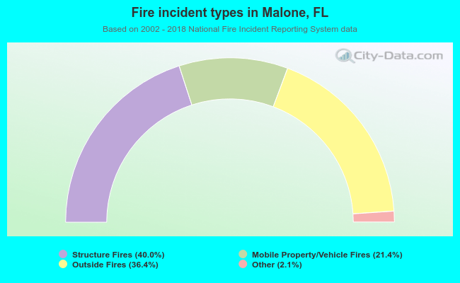 When looking into fire subcategories, the most reports belonged to: Structure Fires (40.0%), and Outside Fires (36.4%).
| Most common first names in Malone, FL among deceased individuals | ||
| Name | Count | Lived (average) |
|---|---|---|
| William | 15 | 71.5 years |
| James | 14 | 67.2 years |
| Willie | 11 | 76.6 years |
| Robert | 10 | 65.5 years |
| Mary | 9 | 78.2 years |
| John | 7 | 77.8 years |
| Annie | 7 | 78.4 years |
| Sarah | 5 | 79.8 years |
| Herman | 4 | 73.8 years |
| Charles | 4 | 63.1 years |
| Most common last names in Malone, FL among deceased individuals | ||
| Last name | Count | Lived (average) |
|---|---|---|
| Smith | 22 | 75.1 years |
| Baxter | 19 | 73.2 years |
| Hall | 10 | 72.0 years |
| Sims | 10 | 70.6 years |
| Herring | 9 | 82.9 years |
| Robinson | 8 | 74.2 years |
| Jones | 7 | 68.0 years |
| Bell | 7 | 72.0 years |
| Williams | 7 | 79.7 years |
| Newton | 7 | 78.0 years |
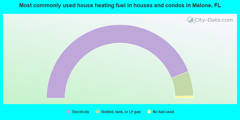
- 88.2%Electricity
- 10.8%Bottled, tank, or LP gas
- 1.0%No fuel used
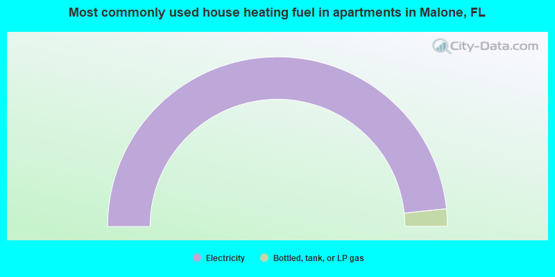
- 96.7%Electricity
- 3.3%Bottled, tank, or LP gas
Malone compared to Florida state average:
- Median house value significantly below state average.
- Unemployed percentage below state average.
- Black race population percentage above state average.
- Foreign-born population percentage significantly below state average.
- Length of stay since moving in significantly above state average.
- House age above state average.
- Institutionalized population percentage significantly above state average.
- Percentage of population with a bachelor's degree or higher significantly below state average.
Malone on our top lists:
- #10 on the list of "Top 101 cities with the largest positive percentage difference between never married males and females (15+ years) (with at least 1,000 males never married)"
- #12 on the list of "Top 101 cities with the largest percentage of people in state prisons (population 1,000+)"
- #23 on the list of "Top 100 cities with the largest percentage of males"