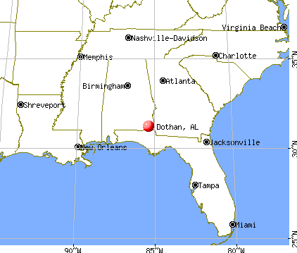
Dothan, Alabama

Dothan: Mural of George Washington Carver on a downtown Dothan, AL building
Dothan: Statue and fountain - Wiregrass Museum of Art - Dothan, AL
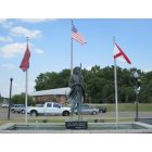
Dothan: Statue and fountain - Wiregrass Museum of Art - Dothan, AL
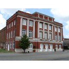
Dothan: Opera House
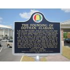
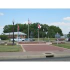
Dothan: Dothan Historic Marker (front) near Dothan Civic Center

Dothan: Dothan Civic Center
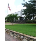
Dothan: Civic Center
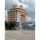
Dothan: WTVY Building (TV station)
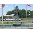
Dothan: Statue and fountain - Wiregrass Museum of Art - Dothan, AL
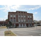
Dothan: Dothan Opera House
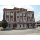
Dothan: Dothan Opera House
- see
15
more - add
your
Submit your own pictures of this city and show them to the world
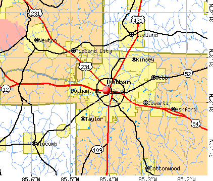
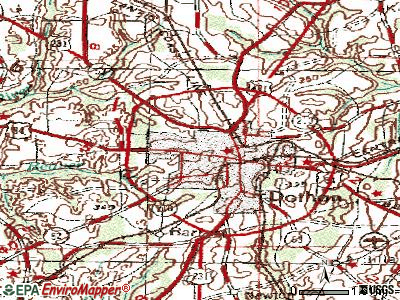
- OSM Map
- General Map
- Google Map
- MSN Map
Population change since 2000: +23.4%
 |
| Males: 33,863 | |
| Females: 37,372 |
| Median resident age: | 38.7 years |
| Alabama median age: | 39.6 years |
Zip codes: 36305, 36345, 36350.
Dothan Zip Code Map| Dothan: | $53,929 |
| AL: | $59,674 |
Estimated per capita income in 2022: $34,127 (it was $20,539 in 2000)
Dothan city income, earnings, and wages data
Estimated median house or condo value in 2022: $190,800 (it was $83,600 in 2000)
| Dothan: | $190,800 |
| AL: | $200,900 |
Mean prices in 2022: all housing units: $247,739; detached houses: $251,991; townhouses or other attached units: $282,646; in 2-unit structures: $105,880; in 3-to-4-unit structures: $102,870; in 5-or-more-unit structures: $291,997; mobile homes: $53,889; occupied boats, rvs, vans, etc.: $110,434
Median gross rent in 2022: $832.
(8.4% for White Non-Hispanic residents, 36.5% for Black residents, 22.3% for Hispanic or Latino residents, 29.8% for American Indian residents, 11.4% for other race residents, 26.2% for two or more races residents)
Detailed information about poverty and poor residents in Dothan, AL


Compare current foreclosures in Dothan, AL:
| Photo | Address | Area | Beds / Baths | Price | Details |
|---|---|---|---|---|---|

|
#1
Headland Ave
Dothan, AL 36303
|
2,480 sq. feet
|
2 baths 5 beds |
$129,900
|
show details |

|
#2
E Chadwick Cir
Dothan, AL 36305
|
1,150 sq. feet
|
2 baths 2 beds |
show details | |

|
#3
Boyce Rd
Dothan, AL 36305
|
1,552 sq. feet
|
2 baths 3 beds |
show details | |

|
#4
Green Valley Rd
Dothan, AL 36305
|
2,402 sq. feet
|
2 baths 4 beds |
show details | |

|
#5
Pine Hills Dr
Dothan, AL 36301
|
1,134 sq. feet
|
2 baths 3 beds |
show details | |

|
#6
Wimbledon Dr
Dothan, AL 36305
|
1,728 sq. feet
|
2 baths 3 beds |
show details | |

|
#7
Pleasant Rd
Dothan, AL 36301
|
1,140 sq. feet
|
1 baths 3 beds |
show details | |

|
#8
Creekwood Dr
Dothan, AL 36301
|
1,332 sq. feet
|
2 baths 3 beds |
show details | |

|
#9
Darlington Cir
Dothan, AL 36301
|
1,306 sq. feet
|
2 baths 3 beds |
show details | |

|
#10
S State Highway 109
Dothan, AL 36301
|
1,490 sq. feet
|
2 baths 3 beds |
show details |
| Photo | Address | Area | Beds / Baths | Price | Details |
|---|---|---|---|---|---|

|
#11
Thorndale Pl
Dothan, AL 36303
|
1,636 sq. feet
|
2 baths 3 beds |
show details | |

|
#12
Wrinn Ln
Dothan, AL 36301
|
1,443 sq. feet
|
2 baths 3 beds |
show details | |

|
#13
Rimson Rd
Dothan, AL 36301
|
1,591 sq. feet
|
2 baths 4 beds |
show details | |

|
#14
E Spring St
Dothan, AL 36303
|
1,458 sq. feet
|
1 baths 2 beds |
show details | |

|
#15
Peachtree Dr
Dothan, AL 36303
|
2,219 sq. feet
|
3 baths 3 beds |
show details | |

|
#16
Richberry Dr
Dothan, AL 36301
|
1,195 sq. feet
|
2 baths 3 beds |
show details | |

|
#17
Berryhill Dr
Dothan, AL 36301
|
2,354 sq. feet
|
2 baths 4 beds |
show details | |

|
#18
Hickory Nut Cir
Dothan, AL 36301
|
1,154 sq. feet
|
2 baths 3 beds |
show details | |

|
#19
S Bell St
Dothan, AL 36301
|
1,588 sq. feet
|
1 baths 3 beds |
show details | |

|
#20
Chandler St
Dothan, AL 36301
|
1,979 sq. feet
|
2 baths 3 beds |
show details |
| Photo | Address | Area | Beds / Baths | Price | Details |
|---|---|---|---|---|---|

|
#21
Crichton Ct
Dothan, AL 36305
|
2,792 sq. feet
|
2 baths 4 beds |
show details | |

|
#22
Scarlet Oaks Ct
Dothan, AL 36301
|
1,551 sq. feet
|
2 baths 3 beds |
show details | |

|
#23
Wg Bond Rd
Dothan, AL 36305
|
1,296 sq. feet
|
2 baths 5 beds |
show details | |

|
#24
Moates St
Dothan, AL 36301
|
1,440 sq. feet
|
1 baths 3 beds |
show details | |

|
#25
Winding Rd
Dothan, AL 36301
|
1,592 sq. feet
|
2 baths 3 beds |
show details | |

|
#26
N Cherry St
Dothan, AL 36303
|
768 sq. feet
|
1 baths 2 beds |
show details | |

|
#27
Eastwood Dr
Dothan, AL 36301
|
1,377 sq. feet
|
2 baths 3 beds |
show details | |

|
#28
Reid Dr
Dothan, AL 36301
|
1,000 sq. feet
|
1 baths 3 beds |
show details | |

|
#29
Creekwood Dr
Dothan, AL 36301
|
1,320 sq. feet
|
2 baths 3 beds |
show details | |

|
#30
Candle Brook Dr
Dothan, AL 36303
|
1,423 sq. feet
|
2 baths 3 beds |
show details |
| Photo | Address | Area | Beds / Baths | Price | Details |
|---|---|---|---|---|---|

|
#31
Fairmont St
Dothan, AL 36303
|
1,769 sq. feet
|
2 baths 3 beds |
show details | |

|
#32
Cumberland Dr
Dothan, AL 36301
|
1,360 sq. feet
|
2 baths 3 beds |
show details | |

|
#33
Rock Spring Rd
Dothan, AL 36303
|
1,404 sq. feet
|
2 baths 3 beds |
show details | |

|
#34
Headland Ave
Dothan, AL 36303
|
1,670 sq. feet
|
2 baths 3 beds |
show details | |

|
#35
Chinook St
Dothan, AL 36303
|
1,025 sq. feet
|
1 baths 3 beds |
show details | |

|
#36
Paul Revere Run
Dothan, AL 36305
|
2,293 sq. feet
|
2 baths 3 beds |
show details | |

|
#37
Eastwood Dr
Dothan, AL 36301
|
1,300 sq. feet
|
2 baths 3 beds |
show details | |

|
#38
Cottonwood Rd
Dothan, AL 36301
|
1,288 sq. feet
|
2 baths 3 beds |
show details | |

|
#39
Coral Ln
Dothan, AL 36305
|
1,536 sq. feet
|
2 baths 3 beds |
show details | |

|
#40
Melrose Ln
Dothan, AL 36303
|
1,421 sq. feet
|
2 baths 3 beds |
show details |
| Photo | Address | Area | Beds / Baths | Price | Details |
|---|---|---|---|---|---|

|
#41
E Cottonwood Rd
Dothan, AL 36301
|
1,259 sq. feet
|
1 baths 2 beds |
show details | |

|
#42
Kristi Lea Dr
Dothan, AL 36303
|
1,668 sq. feet
|
2 baths 3 beds |
show details | |

|
#43
Glen Lawrence Rd
Dothan, AL 36303
|
1,674 sq. feet
|
2 baths 3 beds |
show details | |

|
#44
Dexter St
Dothan, AL 36301
|
2,275 sq. feet
|
2 baths - beds |
show details | |

|
#45
Omussee Rd
Dothan, AL 36303
|
1,268 sq. feet
|
2 baths 3 beds |
show details | |

|
#46
Shadowlawn Dr
Dothan, AL 36303
|
1,811 sq. feet
|
2 baths 3 beds |
show details | |

|
#47
Southland Dr
Dothan, AL 36301
|
1,302 sq. feet
|
1 baths 3 beds |
show details | |

|
#48
Superior Dr
Dothan, AL 36301
|
1,576 sq. feet
|
2 baths 3 beds |
show details | |

|
#49
S Bell St
Dothan, AL 36301
|
868 sq. feet
|
1 baths 3 beds |
show details | |

|
Check over 1 million property listings on Foreclosure.com!
|
browse all offers | |||


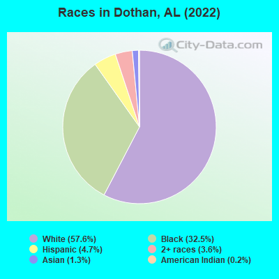
- 40,62957.6%White alone
- 22,92732.5%Black alone
- 3,3374.7%Hispanic
- 2,5383.6%Two or more races
- 8881.3%Asian alone
- 1550.2%American Indian alone
- 500.07%Other race alone
According to our research of Alabama and other state lists, there were 181 registered sex offenders living in Dothan, Alabama as of May 04, 2024.
The ratio of all residents to sex offenders in Dothan is 377 to 1.
The ratio of registered sex offenders to all residents in this city is near the state average.
The City-Data.com crime index weighs serious crimes and violent crimes more heavily. Higher means more crime, U.S. average is 246.1. It adjusts for the number of visitors and daily workers commuting into cities.
- means the value is smaller than the state average.- means the value is about the same as the state average.
- means the value is bigger than the state average.
- means the value is much bigger than the state average.

Crime rate in Dothan detailed stats: murders, rapes, robberies, assaults, burglaries, thefts, arson
Full-time law enforcement employees in 2021, including police officers: 224 (158 officers - 143 male; 15 female).
| Officers per 1,000 residents here: | 2.27 |
| Alabama average: | 2.40 |
 Recent articles from our blog. Our writers, many of them Ph.D. graduates or candidates, create easy-to-read articles on a wide variety of topics.

 | Montgomery vs Dothan area (46 replies) |
| Dothan Al. for retiree (20 replies) |
| Moving to Dothan from Houston area (16 replies) |
| Dothan vs. Lillian, AL (or suburbs) (8 replies) |
| Considering Houston County, Dothan/Eufaula maybe? (10 replies) |
| Thinking of moving to Dothan area (6 replies) |
Latest news from Dothan, AL collected exclusively by city-data.com from local newspapers, TV, and radio stations
Ancestries: American (14.9%), English (10.6%), Irish (5.4%), German (3.0%), European (1.9%), Scottish (1.2%).
Current Local Time: CST time zone
Incorporated on 11/11/1885
Elevation: 324 feet
Land area: 86.6 square miles.
Population density: 822 people per square mile (low).
2,241 residents are foreign born (1.4% Latin America, 1.2% Asia).
| This city: | 3.1% |
| Alabama: | 3.5% |
Median real estate property taxes paid for housing units with mortgages in 2022: $593 (0.3%)
Median real estate property taxes paid for housing units with no mortgage in 2022: $510 (0.3%)
Nearest city with pop. 200,000+: Montgomery, AL  (93.7 miles , pop. 201,568).
Nearest city with pop. 1,000,000+: Houston, TX (602.9 miles , pop. 1,953,631).
Nearest cities:
), ), ), ), ), ), )Latitude: 31.23 N, Longitude: 85.41 W
Daytime population change due to commuting: +15,258 (+21.6%)
Workers who live and work in this city: 23,627 (74.5%)
Area code: 334

Dothan, Alabama accommodation & food services, waste management - Economy and Business Data
Single-family new house construction building permits:
- 2022: 210 buildings, average cost: $310,000
- 2021: 249 buildings, average cost: $313,200
- 2020: 231 buildings, average cost: $277,100
- 2019: 194 buildings, average cost: $248,600
- 2018: 176 buildings, average cost: $261,400
- 2017: 184 buildings, average cost: $284,100
- 2016: 204 buildings, average cost: $272,300
- 2015: 217 buildings, average cost: $262,600
- 2014: 176 buildings, average cost: $298,000
- 2013: 192 buildings, average cost: $273,700
- 2012: 173 buildings, average cost: $240,700
- 2011: 206 buildings, average cost: $208,600
- 2010: 192 buildings, average cost: $200,300
- 2009: 197 buildings, average cost: $213,500
- 2008: 315 buildings, average cost: $128,600
- 2007: 296 buildings, average cost: $101,800
- 2006: 610 buildings, average cost: $86,600
- 2005: 501 buildings, average cost: $74,100
- 2004: 415 buildings, average cost: $76,400
- 2003: 373 buildings, average cost: $101,600
- 2002: 325 buildings, average cost: $74,700
- 2001: 288 buildings, average cost: $64,300
- 2000: 305 buildings, average cost: $60,800
- 1999: 329 buildings, average cost: $56,900
- 1998: 291 buildings, average cost: $62,500
- 1997: 299 buildings, average cost: $63,600
| Here: | 2.8% |
| Alabama: | 2.6% |
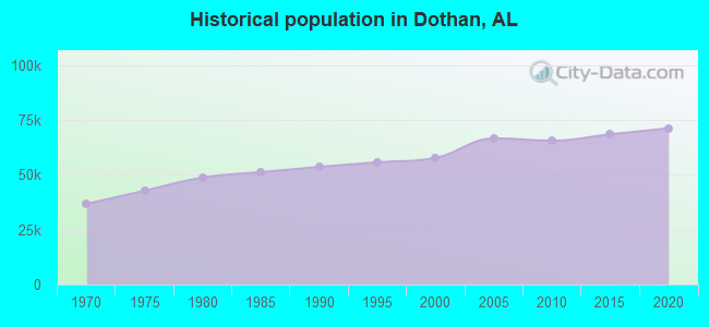
Population change in the 1990s: +2,216 (+4.0%).
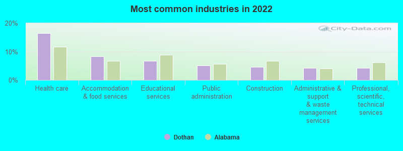
- Health care (16.4%)
- Accommodation & food services (8.4%)
- Educational services (6.7%)
- Public administration (5.1%)
- Construction (4.6%)
- Administrative & support & waste management services (4.2%)
- Professional, scientific, technical services (4.2%)
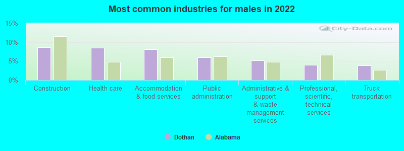
- Construction (8.7%)
- Health care (8.5%)
- Accommodation & food services (8.1%)
- Public administration (6.0%)
- Administrative & support & waste management services (5.2%)
- Professional, scientific, technical services (4.0%)
- Truck transportation (3.9%)
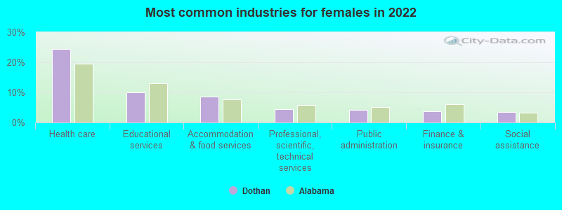
- Health care (24.4%)
- Educational services (10.0%)
- Accommodation & food services (8.7%)
- Professional, scientific, technical services (4.4%)
- Public administration (4.3%)
- Finance & insurance (3.7%)
- Social assistance (3.5%)

- Cooks and food preparation workers (8.2%)
- Other management occupations, except farmers and farm managers (4.8%)
- Laborers and material movers, hand (4.3%)
- Building and grounds cleaning and maintenance occupations (4.2%)
- Retail sales workers, except cashiers (3.9%)
- Registered nurses (3.4%)
- Health technologists and technicians (3.4%)

- Cooks and food preparation workers (8.5%)
- Laborers and material movers, hand (6.8%)
- Building and grounds cleaning and maintenance occupations (5.5%)
- Other management occupations, except farmers and farm managers (5.2%)
- Driver/sales workers and truck drivers (5.0%)
- Retail sales workers, except cashiers (4.2%)
- Vehicle and mobile equipment mechanics, installers, and repairers (3.3%)

- Cooks and food preparation workers (7.8%)
- Registered nurses (6.2%)
- Health technologists and technicians (5.6%)
- Other management occupations, except farmers and farm managers (4.3%)
- Secretaries and administrative assistants (4.1%)
- Cashiers (4.0%)
- Other office and administrative support workers, including supervisors (3.8%)
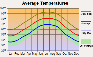
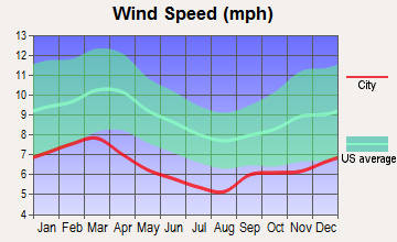
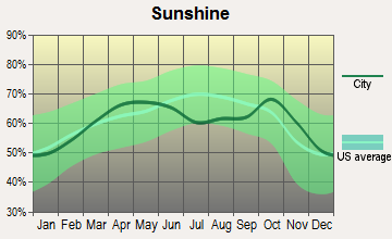
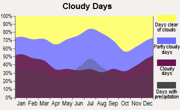
Average climate in Dothan, Alabama
Based on data reported by over 4,000 weather stations


|
|

(lower is better)

Air Quality Index (AQI) level in 2019 was 47.9. This is significantly better than average.
| City: | 47.9 |
| U.S.: | 72.6 |
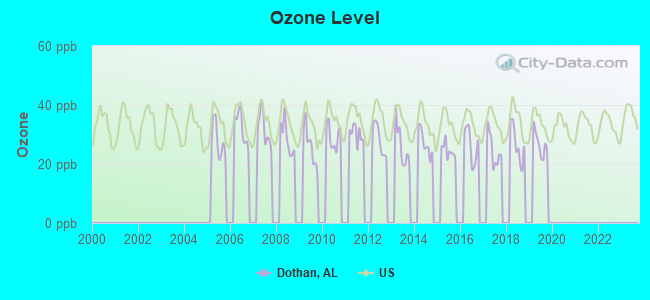
Ozone [ppb] level in 2019 was 26.7. This is better than average. Closest monitor was 2.8 miles away from the city center.
| City: | 26.7 |
| U.S.: | 33.3 |
Tornado activity:
Dothan-area historical tornado activity is slightly below Alabama state average. It is 53% greater than the overall U.S. average.
On 3/1/2007, a category F4 (max. wind speeds 207-260 mph) tornado 30.5 miles away from the Dothan city center killed 9 people and injured 50 people and caused $250 million in damages.
On 12/29/1973, a category F3 (max. wind speeds 158-206 mph) tornado 9.1 miles away from the city center injured 2 people and caused between $500,000 and $5,000,000 in damages.
Earthquake activity:
Dothan-area historical earthquake activity is significantly above Alabama state average. It is 7% greater than the overall U.S. average.On 10/24/1997 at 08:35:17, a magnitude 4.9 (4.8 MB, 4.2 MS, 4.9 LG, Depth: 6.2 mi, Class: Light, Intensity: IV - V) earthquake occurred 110.6 miles away from Dothan center
On 1/18/1999 at 07:00:53, a magnitude 4.8 (4.8 MB, 4.0 LG, Depth: 0.6 mi) earthquake occurred 185.3 miles away from Dothan center
On 4/29/2003 at 08:59:39, a magnitude 4.9 (4.4 MB, 4.6 MW, 4.9 LG) earthquake occurred 226.3 miles away from the city center
On 8/2/1974 at 08:52:09, a magnitude 4.9 (4.3 MB, 4.9 LG) earthquake occurred 249.8 miles away from Dothan center
On 4/29/2003 at 08:59:39, a magnitude 4.6 (4.6 MW, Depth: 12.3 mi) earthquake occurred 226.3 miles away from the city center
On 11/7/2004 at 11:20:21, a magnitude 4.3 (4.3 MW, Depth: 3.1 mi) earthquake occurred 177.9 miles away from the city center
Magnitude types: regional Lg-wave magnitude (LG), body-wave magnitude (MB), surface-wave magnitude (MS), moment magnitude (MW)
Natural disasters:
The number of natural disasters in Houston County (21) is greater than the US average (15).Major Disasters (Presidential) Declared: 13
Emergencies Declared: 5
Causes of natural disasters: Storms: 10, Floods: 8, Tornadoes: 8, Hurricanes: 7, Winds: 5, Drought: 1, Snowfall: 1, Tropical Storm: 1, Winter Storm: 1, Other: 1 (Note: some incidents may be assigned to more than one category).
Main business address for: MOVIE GALLERY INC (SERVICES-VIDEO TAPE RENTAL).
Hospitals in Dothan:
- COVENANT HOSPICE INC (2855 ROSS CLARK CIRCLE, SUITE 110)
- FLOWERS HOSPITAL (Proprietary, provides emergency services, 4370 WEST MAIN STREET)
- LONG TERM HOSPITAL OF DOTHAN, LLC (1108 ROSS CLARK CIRCLE 4TH FLOOR)
- SOUTHEAST ALABAMA MEDICAL CENTER (Government - Hospital District or Authority, 1108 ROSS CLARK CIRCLE)
Nursing Homes in Dothan:
- EXTENDICARE HEALTH CENTER (950 SOUTH ST. ANDREWS STREET)
- WESLEY MANOR RETIREMENT CENTER (718 HONEYSUCKLE ROAD)
- WESTSIDE TERRACE HEALTH AND REHABILITATION CENTER (501 NORTH WOODBURN DRIVE)
Dialysis Facilities in Dothan:
- DAVITA WIREGRASS KIDNEY CENTER (1450 ROSS CLARK CIRCLE)
- DCI DOTHAN (1630 COLUMBIA HWY)
- DOTHAN DIALYSIS (216 GRACELAND DR.)
Home Health Centers in Dothan:
Airports and heliports located in Dothan:
- Dothan Regional Airport (DHN) (Runways: 2, Commercial Ops: 8,858, Air Taxi Ops: 3,242, Itinerant Ops: 47,086, Local Ops: 72,634, Military Ops: 95,400)
- Flowers Hospital Heliport (AL59)
- Southeast Alabama Medical Center Heliport (AL20)
- Toth Stagefield Ahp Heliport (24AL)
Nuclear power plants:
- Joseph M. Farley 1. Westinghouse Electric Corp.Bechtel Corp.Westinghouse Electric Corp.Southern Nuclear Operating Co.Pressurized Water Reactor (PWR). Net Output: 814 MWe. Operable. Initial criticality: 08/1977. Commercial start: 12/1977..
- Joseph M. Farley 2. Westinghouse Electric Corp.Bechtel Corp.Westinghouse Electric Corp.Southern Nuclear Operating Co.Pressurized Water Reactor (PWR). Net Output: 822 MWe. Operable. Initial criticality: 05/1981. Commercial start: 07/1981..
Colleges/Universities in Dothan:
Other colleges/universities with over 2000 students near Dothan:
- Enterprise State Community College (about 26 miles; Enterprise, AL; Full-time enrollment: 2,101)
- Troy University (about 51 miles; Troy, AL; FT enrollment: 16,148)
- Bainbridge State College (about 57 miles; Bainbridge, GA; FT enrollment: 2,308)
- Gulf Coast State College (about 75 miles; Panama City, FL; FT enrollment: 4,474)
- Darton State College (about 75 miles; Albany, GA; FT enrollment: 5,000)
- Albany Technical College (about 77 miles; Albany, GA; FT enrollment: 3,707)
- Albany State University (about 79 miles; Albany, GA; FT enrollment: 3,662)
Public high schools in Dothan:
- DOTHAN HIGH SCH (Students: 1,399, Location: 1236 S OATES ST, Grades: 9-12)
- NORTHVIEW HIGH SCH (Students: 1,146, Location: 3209 REEVES ST, Grades: 9-12)
- REHOBETH HIGH SCH (Students: 685, Location: 373 MALVERN ROAD, Grades: 9-12)
- DOTHAN TECH CTR (Location: 3165 REEVES ST, Grades: 9-12)
- HOUSTON CO ALT SCH (Location: 315 N FOSTER ST, Grades: KG-12)
- HOPE HIGH SCHOOL (Location: 1971 REEVES ST. SUITE 21, Grades: 9-12)
Private high schools in Dothan:
- PROVIDENCE CHRISTIAN SCHOOL (Students: 708, Location: 4847 MURPHY MILL RD, Grades: 1-12)
- HOUSTON ACADEMY (Students: 615, Location: 901 BUENA VISTA DR, Grades: PK-12)
- EMMANUEL CHRISTIAN SCHOOL (Students: 492, Location: 178 EARLINE RD, Grades: PK-12)
- NORTHSIDE METHODIST CHURCH & ACADEMY (Students: 370, Location: 2600 REDMOND RD, Grades: PK-12)
Biggest public elementary/middle schools in Dothan:
- HIDDEN LAKE ELEM SCH (Students: 547, Location: 1475 PREVATT RD, Grades: KG-5)
- HIGHLANDS ELEM SCH (Students: 512, Location: 1400 S BRANNON STAND RD, Grades: KG-5)
- MONTANA STREET ACADC MAGNET SCH (Students: 447, Location: 1001 MONTANA ST, Grades: KG-5)
- HONEYSUCKLE MIDDLE SCH (Students: 440, Location: 1665 HONEYSUCKLE RD, Grades: 6-8)
- GIRARD MIDDLE SCH (Students: 421, Location: 600 GIRARD AVE, Grades: 6-8)
- SELMA STREET ELEM SCH (Students: 399, Location: 1501 W SELMA ST, Grades: KG-5)
- KELLY SPRINGS ELEM SCH (Students: 394, Location: 1124 KELLY SPRINGS RD, Grades: KG-5)
- GRANDVIEW ELEM SCH (Students: 363, Location: 900 SIXTH AVENUE, Grades: KG-5)
- LANDMARK ELEM SCH (Students: 346, Location: 4130 WESTGATE PARKWAY, Grades: KG-5)
- GIRARD ELEM SCH (Students: 310, Location: 522 GIRARD AVE, Grades: KG-5)
Private elementary/middle schools in Dothan:
User-submitted facts and corrections:
- Atlanta is the closest city to Dothan, Al with a population in excess of 1 million residents.
- This catagory: Other colleges/universities with over 2000 students near Dothan: Florida State University, Tallahassee 96 Miles Florida State University, Panama City Campus ~90 Miles Florida A&M University, Tallahassee 99 Miles added by Todd
- New Dothan radio station premiere's March 1, 2007. OLDIES 700....The Big Wheel.....owned by broadcast legend, Jack Gale (82 year young), and his wife Lovey. Listen on the internet or live. Call them at 334-797-4688!
Points of interest:
Notable locations in Dothan: Tri-State Fair and Exposition (A), Dothan Country Club (B), Dothan Prison Camp (C), Dothan Speedway (D), Lincoln Community Center (E), Dothan Pavilion Shopping District (F), Water World and Westgate Recreational Complex (G), National Peanut Festival Fairgrounds (H), Highland Oaks Golf Course (I), Kilgore's Roundabout Plantation Golf Course (J), Houston County Farm Center (K), City of Choctawhatchee Wastewater Treatment Plant (L), Westgate Industrial Park (M), Sam Houston Industrial Park (N), City of Dothan Sanitary Landfill (O), Beaver Creek Sewage Treatment Plant (P), Cypress Creek Sewage Treatment Plant (Q), Farm Center (R), Limestone Creek Sewage Treatment Plant (S), Omussee Creek Sewage Treatment Plant (T). Display/hide their locations on the map
Shopping Centers: Wiregrass Mall Shopping Center (1), Woodland Shopping Center (2), Wise Shopping Center (3), Bel Aire Shopping Center (4), Circle West Shopping Center (5), Colonial Court Shopping Center (6), Colony Shopping Center (7), Country Corner Shopping Center (8), Fountain Plaza Shopping Center (9). Display/hide their locations on the map
Main business address in Dothan: MOVIE GALLERY INC (A). Display/hide its location on the map
Churches in Dothan include: Rocky Branch Church (A), Mount Zion Baptist Church (B), Saint Theresa Catholic Church (C), Lafayette Street Methodist Episcopal Church (D), Greater Beulah Baptist Church (E), Little Vine Primitive Baptist Church (F), Selma Baptist Church (G), Shady Grove Church (H), Zion African Methodist Episcopal Church (I). Display/hide their locations on the map
Cemeteries: Memory Hill Cemetery (1), Hurts Chapel Cemetery (2), Selma Cemetery (3), Mount Zion Cemetery (4), Mount Pleasant Cemetery (5), Little Vine Cemetery (6), Beulah Cemetery (7). Display/hide their locations on the map
Lakes and reservoirs: Porters Lake (A), Green Valley Farm Ponds (B), Dye Pond (C), Pine Lake (D), Coleman Pond (E), Spann Ponds (F), Kelly Lake (G), Murphy Millpond (H). Display/hide their locations on the map
Streams, rivers, and creeks: Rock Creek (A), Poplar Spring Branch (B), Newton Creek (C), Murphy Mill Branch (D), Golf Creek (E), Beaver Creek (F). Display/hide their locations on the map
Parks in Dothan include: Rip Hewes Stadium (1), Wiregrass Stadium (2), Wiregrass Memorial Park (3), Wilson Street Park (4), Westgate Memorial Park (5), Pitman Field (6), Murphys Mill Historical Site (7), Landmark Park (8), Kelly Springs Recreation Area (9). Display/hide their locations on the map
Tourist attractions: GW Carver Interpretive Museum (305 North Foster Street) (1), Dothan Landmarks Foundation (Museums; 430 Landmark Drive # 431N) (2), Wiregrass Museum of Art (126 Museum Avenue) (3), Dothan Area Botanical Gardens (Cultural Attractions- Events- & Facilities; 5130 Headland Avenue) (4), Playground Family Fun-Nasium (Amusement & Theme Parks; 465 Westgate Parkway) (5), Dothan Survival Games (Amusement & Theme Parks; Highway 84 East) (6), Alabama Welcome Center (15121 South US231) (7), Suzuki-Honda of Dothan (Tours & Charters; 2003 Ross Clark Circle) (8). Display/hide their approximate locations on the map
Hotels: Walker's Deluxe Motel (3212 East Main Street) (1), Holiday Inn (3053 Ross Clark Cir) (2), Comfort Inn Dothan (3593 Ross Clark Circle Northwest) (3), Motel 6 (2907 Ross Clark Circle) (4), Quality Inn Dothan (3053 Ross Clark Circle) (5), Super 8 Motel (2215 Ross Clark Circle) (6), Adams Inn (3145 Montgomery Highway) (7), GuestHouse Inn Dothan- AL (1075 Ross Clark Circle) (8), Dothan Motor Lodge (2155 Montgomery Highway) (9). Display/hide their approximate locations on the map
Courts: Houston County Government - Juvenile Court Services (179 North Foster Street) (1), Houston County Government - Court Systems- District Attorney- Coroner (179 North Foster Street) (2), United States Government - Clerk U S Court (100 Troy) (3), Houston County Government - Court Systems- Circuit Court- Circuit C (114 North Oates Street) (4). Display/hide their approximate locations on the map
Birthplace of: Bill Baxley - Alabama politician, Burton Lawless - College football player, Donna D'Errico - Actress and model, Frank Dempsey - College football player, Gardner Dickinson - Professional golfer, Heather Whitestone - Model, Izell Reese - 2005 NFL player (Dallas Cowboys, born: May 7, 1974), Johnny Mack Brown - Football player, Larry Brackins - Football player, Matt Cain - 2005 Major League Baseball player (San Francisco Giants, born: Oct 1, 1984).
Drinking water stations with addresses in Dothan and their reported violations in the past:
DOTHAN UTILITIES (CITY OF) (Population served: 97,545, Groundwater):Past monitoring violations:
- Monitoring, Source Water (GWR) - In OCT-30-2013, Contaminant: E. COLI
- Monitoring and Reporting (DBP) - Between FEB-05-2013 and MAY-06-2013, Contaminant: TTHM. Follow-up actions: St Compliance achieved (OCT-10-2013)
- Monitoring and Reporting (DBP) - Between FEB-05-2013 and MAY-06-2013, Contaminant: Total Haloacetic Acids (HAA5). Follow-up actions: St Compliance achieved (OCT-10-2013)
- Monitoring and Reporting (DBP) - Between NOV-09-2012 and FEB-04-2013, Contaminant: TTHM. Follow-up actions: St Compliance achieved (JUN-27-2013)
- Monitoring and Reporting (DBP) - Between NOV-09-2012 and FEB-04-2013, Contaminant: Total Haloacetic Acids (HAA5). Follow-up actions: St Compliance achieved (JUN-27-2013)
- 92 regular monitoring violations
- 8 other older monitoring violations
Drinking water stations with addresses in Dothan that have no violations reported:
- HOUSTON COUNTY WATER AUTHORITY (Population served: 4,050, Primary Water Source Type: Groundwater)
| This city: | 2.4 people |
| Alabama: | 2.5 people |
| This city: | 66.4% |
| Whole state: | 67.8% |
| This city: | 5.2% |
| Whole state: | 4.7% |
Likely homosexual households (counted as self-reported same-sex unmarried-partner households)
- Lesbian couples: 0.3% of all households
- Gay men: 0.3% of all households
People in group quarters in Dothan in 2010:
- 484 people in nursing facilities/skilled-nursing facilities
- 439 people in local jails and other municipal confinement facilities
- 114 people in correctional residential facilities
- 76 people in group homes intended for adults
- 72 people in mental (psychiatric) hospitals and psychiatric units in other hospitals
- 62 people in other noninstitutional facilities
- 32 people in residential treatment centers for adults
- 26 people in emergency and transitional shelters (with sleeping facilities) for people experiencing homelessness
- 25 people in group homes for juveniles (non-correctional)
- 21 people in correctional facilities intended for juveniles
- 16 people in hospitals with patients who have no usual home elsewhere
- 2 people in workers' group living quarters and job corps centers
People in group quarters in Dothan in 2000:
- 556 people in nursing homes
- 383 people in local jails and other confinement facilities (including police lockups)
- 80 people in other noninstitutional group quarters
- 45 people in short-term care, detention or diagnostic centers for delinquent children
- 30 people in hospitals/wards and hospices for chronically ill
- 30 people in other hospitals or wards for chronically ill
- 16 people in schools, hospitals, or wards for the intellectually disabled
- 9 people in other nonhousehold living situations
- 8 people in other group homes
Banks with most branches in Dothan (2011 data):
- Regions Bank: 7 branches. Info updated 2011/02/24: Bank assets: $123,368.2 mil, Deposits: $98,301.3 mil, headquarters in Birmingham, AL, positive income, Commercial Lending Specialization, 1778 total offices, Holding Company: Regions Financial Corporation
- Wells Fargo Bank, National Association: 7 branches. Info updated 2011/04/05: Bank assets: $1,161,490.0 mil, Deposits: $905,653.0 mil, headquarters in Sioux Falls, SD, positive income, 6395 total offices, Holding Company: Wells Fargo & Company
- MidSouth Bank, N. A.: Southside Branch, Westside Branch, Northside Branch, Midsouth Bank, N. A.. Info updated 2006/11/03: Bank assets: $374.8 mil, Deposits: $334.2 mil, local headquarters, positive income, Commercial Lending Specialization, 9 total offices, Holding Company: Midsouth Bancorporation
- Compass Bank: Dothan West Branch, Dothan Main Branch, Wiregrass Branch. Info updated 2011/02/24: Bank assets: $63,107.0 mil, Deposits: $46,232.4 mil, headquarters in Birmingham, AL, negative income in the last year, Commercial Lending Specialization, 720 total offices, Holding Company: Banco Bilbao Vizcaya Argentaria, S.A.
- Ameris Bank: Dothan Branch, Dothan - Hwy 84 Ext Branch, Houston County, Al. Info updated 2012/02/27: Bank assets: $3,003.2 mil, Deposits: $2,595.8 mil, headquarters in Moultrie, GA, positive income, Commercial Lending Specialization, 79 total offices, Holding Company: Ameris Bancorp
- ServisFirst Bank: Dothan Branch at 4801 West Main Street, branch established on 2008/09/30; Cottonwoods Corners Branch at 1640 Ross Clark Circle, branch established on 2011/02/01. Info updated 2011/02/24: Bank assets: $2,460.2 mil, Deposits: $2,146.9 mil, headquarters in Birmingham, AL, positive income, Commercial Lending Specialization, 10 total offices, Holding Company: Servisfirst Bancshares, Inc.
- Synovus Bank: Dothan Pavillion at 4355 Montgomery Highway, branch established on 2008/08/04; Dothan Branch at 3680 West Main Street, branch established on 1966/11/28. Info updated 2011/01/25: Bank assets: $26,863.3 mil, Deposits: $22,415.0 mil, headquarters in Columbus, GA, positive income, Commercial Lending Specialization, 296 total offices, Holding Company: Synovus Financial Corp.
- PeoplesSouth Bank: Westside Branch at 2926 Ross Clark Circle, branch established on 1992/12/21; Dothan North Branch at 2861 John D Odom Road, branch established on 2008/04/28. Info updated 2006/11/03: Bank assets: $534.5 mil, Deposits: $446.4 mil, headquarters in Colquitt, GA, positive income, Commercial Lending Specialization, 19 total offices, Holding Company: Peoplessouth Bancshares, Inc.
- BankSouth: Banksouth at 3251 Ross Clark Circle, branch established on 1928/01/01. Info updated 2006/11/03: Bank assets: $193.8 mil, Deposits: $158.3 mil, local headquarters, positive income, Commercial Lending Specialization, 3 total offices, Holding Company: Bancsouth Corporation
- 4 other banks with 4 local branches
For population 15 years and over in Dothan:
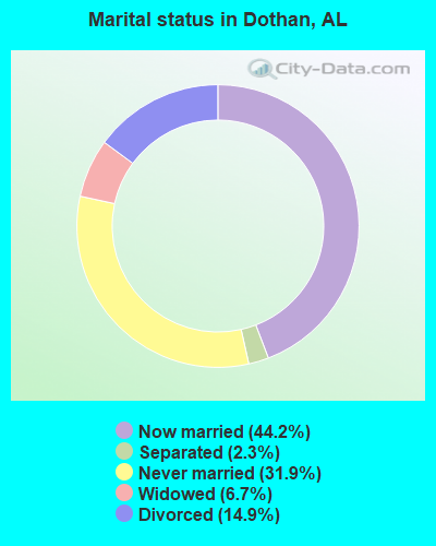
- Never married: 31.9%
- Now married: 44.2%
- Separated: 2.3%
- Widowed: 6.7%
- Divorced: 14.9%
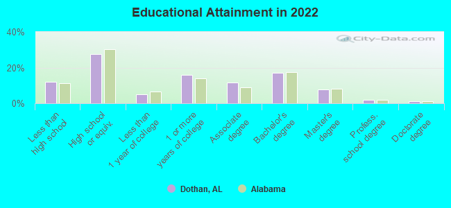
For population 25 years and over in Dothan:
- High school or higher: 88.1%
- Bachelor's degree or higher: 27.9%
- Graduate or professional degree: 10.8%
- Unemployed: 5.8%
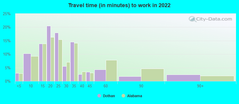
- Mean travel time to work (commute): 21.5 minutes
| Here: | 11.0 |
| Alabama average: | 11.5 |
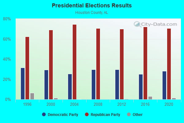
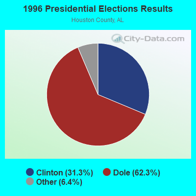


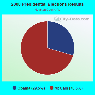
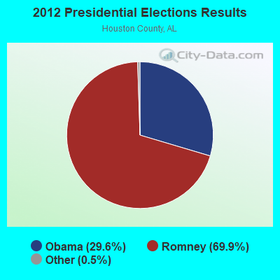
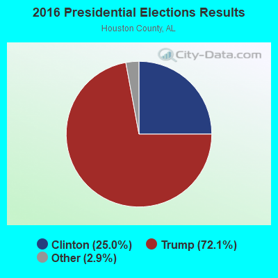

Graphs represent county-level data. Detailed 2008 Election Results
Religion statistics for Dothan, AL (based on Houston County data)
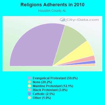
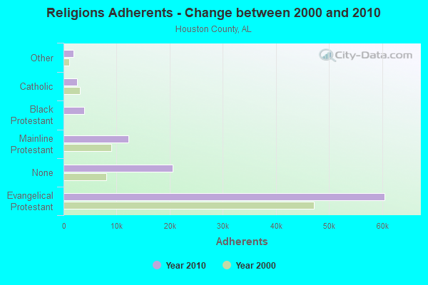
| Religion | Adherents | Congregations |
|---|---|---|
| Evangelical Protestant | 60,486 | 152 |
| Mainline Protestant | 12,245 | 31 |
| Black Protestant | 3,855 | 18 |
| Catholic | 2,551 | 1 |
| Other | 1,882 | 7 |
| Orthodox | 40 | 1 |
| None | 20,488 | - |
Food Environment Statistics:
| Houston County: | 1.65 / 10,000 pop. |
| State: | 1.89 / 10,000 pop. |
| Houston County: | 0.31 / 10,000 pop. |
| Alabama: | 0.20 / 10,000 pop. |
| Houston County: | 0.10 / 10,000 pop. |
| Alabama: | 0.65 / 10,000 pop. |
| Here: | 7.01 / 10,000 pop. |
| State: | 6.32 / 10,000 pop. |
| This county: | 7.21 / 10,000 pop. |
| Alabama: | 5.75 / 10,000 pop. |
| Here: | 11.7% |
| Alabama: | 11.8% |
| Houston County: | 33.0% |
| Alabama: | 31.7% |
| Houston County: | 18.9% |
| Alabama: | 13.5% |
Health and Nutrition:
| Dothan: | 48.7% |
| Alabama: | 49.0% |
| This city: | 44.7% |
| State: | 45.7% |
| This city: | 29.0 |
| State: | 28.9 |
| Dothan: | 21.1% |
| Alabama: | 20.7% |
| Dothan: | 11.2% |
| Alabama: | 11.0% |
| Dothan: | 6.8 |
| Alabama: | 6.8 |
| This city: | 34.9% |
| State: | 34.4% |
| Here: | 54.1% |
| State: | 55.2% |
| This city: | 78.8% |
| Alabama: | 79.3% |
More about Health and Nutrition of Dothan, AL Residents
| Local government employment and payroll (March 2022) | |||||
| Function | Full-time employees | Monthly full-time payroll | Average yearly full-time wage | Part-time employees | Monthly part-time payroll |
|---|---|---|---|---|---|
| Firefighters | 171 | $949,051 | $66,600 | 0 | $0 |
| Police Protection - Officers | 165 | $852,129 | $61,973 | 10 | $21,743 |
| Parks and Recreation | 84 | $361,227 | $51,604 | 74 | $103,056 |
| Electric Power | 79 | $464,621 | $70,575 | 0 | $0 |
| Solid Waste Management | 78 | $289,682 | $44,566 | 0 | $0 |
| Sewerage | 71 | $306,030 | $51,723 | 0 | $0 |
| Other and Unallocable | 63 | $280,991 | $53,522 | 0 | $0 |
| Financial Administration | 52 | $267,701 | $61,777 | 2 | $2,192 |
| Other Government Administration | 46 | $291,390 | $76,015 | 7 | $14,308 |
| Streets and Highways | 40 | $164,495 | $49,349 | 0 | $0 |
| Police - Other | 39 | $168,302 | $51,785 | 11 | $7,961 |
| Water Supply | 38 | $186,087 | $58,764 | 0 | $0 |
| Correction | 24 | $96,565 | $48,283 | 0 | $0 |
| Judicial and Legal | 20 | $114,914 | $68,948 | 0 | $0 |
| Housing and Community Development (Local) | 14 | $83,890 | $71,906 | 0 | $0 |
| Health | 10 | $35,395 | $42,474 | 0 | $0 |
| Fire - Other | 3 | $13,690 | $54,760 | 0 | $0 |
| Totals for Government | 997 | $4,926,158 | $59,292 | 104 | $149,260 |
Dothan government finances - Expenditure in 2021 (per resident):
- Construction - Sewerage: $6,629,000 ($93.06)
Water Utilities: $5,055,000 ($70.96)
Parks and Recreation: $4,385,000 ($61.56)
Regular Highways: $3,624,000 ($50.87)
Electric Utilities: $1,910,000 ($26.81)
Local Fire Protection: $591,000 ($8.30)
Police Protection: $440,000 ($6.18)
Central Staff Services: $436,000 ($6.12)
General - Other: $70,000 ($0.98)
- Current Operations - Electric Utilities: $69,371,000 ($973.83)
Police Protection: $22,357,000 ($313.85)
Sewerage: $17,353,000 ($243.60)
Local Fire Protection: $16,616,000 ($233.26)
General - Other: $15,269,000 ($214.35)
Parks and Recreation: $11,838,000 ($166.18)
Solid Waste Management: $7,081,000 ($99.40)
Regular Highways: $6,760,000 ($94.90)
Water Utilities: $5,914,000 ($83.02)
Central Staff Services: $4,232,000 ($59.41)
Financial Administration: $3,479,000 ($48.84)
Protective Inspection and Regulation - Other: $2,074,000 ($29.11)
Judicial and Legal Services: $1,920,000 ($26.95)
General Public Buildings: $1,896,000 ($26.62)
Correctional Institutions: $1,849,000 ($25.96)
Health - Other: $1,050,000 ($14.74)
Housing and Community Development: $434,000 ($6.09)
Public Welfare - Other: $278,000 ($3.90)
- General - Interest on Debt: $2,666,000 ($37.43)
- Intergovernmental to Local - Other - General - Other: $3,744,000 ($52.56)
Other - Libraries: $730,000 ($10.25)
Other - Transit Utilities: $135,000 ($1.90)
Other - Air Transportation: $51,000 ($0.72)
Other - Police Protection: $20,000 ($0.28)
Other - Judicial and Legal Services: $12,000 ($0.17)
Other - Health - Other: $11,000 ($0.15)
Other - Public Welfare - Other: $4,000 ($0.06)
- Other Capital Outlay - Electric Utilities: $1,248,000 ($17.52)
Police Protection: $1,207,000 ($16.94)
General - Other: $712,000 ($10.00)
Regular Highways: $594,000 ($8.34)
Solid Waste Management: $589,000 ($8.27)
Central Staff Services: $366,000 ($5.14)
Water Utilities: $321,000 ($4.51)
Sewerage: $178,000 ($2.50)
Parks and Recreation: $125,000 ($1.75)
Local Fire Protection: $21,000 ($0.29)
- Total Salaries and Wages: $56,934,000 ($799.24)
Dothan government finances - Revenue in 2021 (per resident):
- Charges - Sewerage: $21,542,000 ($302.41)
Solid Waste Management: $4,755,000 ($66.75)
Other: $2,117,000 ($29.72)
Parks and Recreation: $1,325,000 ($18.60)
- Federal Intergovernmental - Housing and Community Development: $563,000 ($7.90)
Highways: $225,000 ($3.16)
Public Welfare: $162,000 ($2.27)
- Miscellaneous - Fines and Forfeits: $935,000 ($13.13)
General Revenue - Other: $897,000 ($12.59)
Interest Earnings: $444,000 ($6.23)
Rents: $88,000 ($1.24)
- Revenue - Electric Utilities: $92,794,000 ($1302.65)
Water Utilities: $11,792,000 ($165.54)
- State Intergovernmental - Other: $7,516,000 ($105.51)
General Local Government Support: $3,468,000 ($48.68)
Public Welfare: $1,136,000 ($15.95)
Highways: $648,000 ($9.10)
- Tax - General Sales and Gross Receipts: $75,560,000 ($1060.71)
Property: $4,078,000 ($57.25)
Occupation and Business License - Other: $3,916,000 ($54.97)
Other Selective Sales: $2,791,000 ($39.18)
Public Utilities Sales: $1,679,000 ($23.57)
Alcoholic Beverage Sales: $1,505,000 ($21.13)
Motor Vehicle License: $814,000 ($11.43)
Other License: $534,000 ($7.50)
Tobacco Products Sales: $231,000 ($3.24)
Dothan government finances - Debt in 2021 (per resident):
- Long Term Debt - Beginning Outstanding - Unspecified Public Purpose: $109,175,000 ($1532.60)
Outstanding Unspecified Public Purpose: $99,291,000 ($1393.85)
Retired Unspecified Public Purpose: $9,884,000 ($138.75)
Dothan government finances - Cash and Securities in 2021 (per resident):
- Other Funds - Cash and Securities: $149,288,000 ($2095.71)
| Businesses in Dothan, AL | ||||
| Name | Count | Name | Count | |
|---|---|---|---|---|
| AT&T | 5 | Kohl's | 1 | |
| Academy Sports + Outdoors | 1 | La Quinta | 1 | |
| Ace Hardware | 1 | La-Z-Boy | 1 | |
| Advance Auto Parts | 3 | Lane Bryant | 1 | |
| Aeropostale | 1 | Lane Furniture | 6 | |
| American Eagle Outfitters | 1 | Little Caesars Pizza | 2 | |
| Applebee's | 1 | Long John Silver's | 1 | |
| Arby's | 3 | Lowe's | 2 | |
| Ashley Furniture | 1 | Marriott | 3 | |
| AutoZone | 2 | Maurices | 1 | |
| Avenue | 1 | Mazda | 1 | |
| Barnes & Noble | 1 | McDonald's | 5 | |
| Baskin-Robbins | 1 | Motel 6 | 1 | |
| Bath & Body Works | 1 | Motherhood Maternity | 1 | |
| Bed Bath & Beyond | 1 | New Balance | 5 | |
| Best Western | 1 | New York & Co | 1 | |
| Burger King | 5 | Nike | 6 | |
| Burlington Coat Factory | 1 | Nissan | 1 | |
| CVS | 3 | Office Depot | 1 | |
| Charlotte Russe | 1 | OfficeMax | 1 | |
| Chevrolet | 1 | Old Navy | 1 | |
| Chick-Fil-A | 2 | Olive Garden | 1 | |
| Chuck E. Cheese's | 1 | Outback | 1 | |
| Church's Chicken | 1 | Outback Steakhouse | 1 | |
| Cinnabon | 1 | Papa John's Pizza | 2 | |
| Clarion | 1 | Payless | 2 | |
| Cold Stone Creamery | 1 | Penske | 1 | |
| Comfort Suites | 1 | PetSmart | 1 | |
| Cracker Barrel | 1 | Pier 1 Imports | 1 | |
| Curves | 1 | Pizza Hut | 2 | |
| Dairy Queen | 2 | Popeyes | 1 | |
| Days Inn | 1 | Publix Super Markets | 2 | |
| Dennys | 1 | RadioShack | 1 | |
| Domino's Pizza | 2 | Red Lobster | 1 | |
| Dunkin Donuts | 1 | Rite Aid | 3 | |
| Econo Lodge | 1 | Ruby Tuesday | 1 | |
| Express | 1 | Rue21 | 1 | |
| FedEx | 12 | Ryan's Grill | 1 | |
| Finish Line | 1 | SAS Shoes | 2 | |
| Firestone Complete Auto Care | 1 | SONIC Drive-In | 3 | |
| Foot Locker | 1 | Sam's Club | 1 | |
| Ford | 1 | Sears | 2 | |
| GNC | 3 | Shoe Carnival | 1 | |
| GameStop | 3 | Sleep Inn | 1 | |
| Gap | 1 | Sprint Nextel | 1 | |
| Goodwill | 3 | Starbucks | 1 | |
| Gymboree | 1 | Subway | 13 | |
| H&R Block | 5 | Super 8 | 1 | |
| Hardee's | 3 | T-Mobile | 4 | |
| Hobby Lobby | 1 | T.G.I. Driday's | 1 | |
| Holiday Inn | 2 | T.J.Maxx | 1 | |
| Home Depot | 1 | Taco Bell | 3 | |
| Honda | 1 | Target | 1 | |
| Hot Topic | 1 | The Limited | 1 | |
| Howard Johnson | 1 | The Room Place | 2 | |
| Hyundai | 1 | Toys"R"Us | 1 | |
| IHOP | 1 | U-Haul | 5 | |
| InTown Suites | 1 | UPS | 14 | |
| JCPenney | 1 | Vans | 1 | |
| JoS. A. Bank | 1 | Verizon Wireless | 1 | |
| Jones New York | 2 | Victoria's Secret | 1 | |
| Journeys | 1 | Waffle House | 6 | |
| Justice | 1 | Walgreens | 3 | |
| KFC | 4 | Walmart | 2 | |
| Kincaid | 1 | Wendy's | 2 | |
| Kmart | 2 | Wet Seal | 1 | |
| Knights Inn | 1 | |||
Strongest AM radio stations in Dothan:
- WOOF (560 AM; 5 kW; DOTHAN, AL; Owner: WOOF, INC.)
- WAGF (1320 AM; 2 kW; DOTHAN, AL)
- WWNT (1450 AM; 1 kW; DOTHAN, AL; Owner: DOVE BROADCASTING, INC.)
- WQLS (1200 AM; 10 kW; OZARK, AL; Owner: STYLES BROADCASTING OF DOTHAN, INC.)
- WTKN (1560 AM; daytime; 5 kW; DALEVILLE, AL; Owner: JOSEPH A. ADAMS, SR.)
- WSTT (730 AM; 25 kW; THOMASVILLE, GA; Owner: MARION R. WILLIAMS)
- WASG (550 AM; 25 kW; ATMORE, AL; Owner: 550 AM, INC)
- WTCL (1580 AM; daytime; 10 kW; CHATTAHOOCHEE, FL; Owner: METZ, INC.)
- WZEP (1460 AM; 10 kW; DEFUNIAK SPRINGS, FL; Owner: WALTON COUNTY BROADCASTING, INC.)
- WMAC (940 AM; 50 kW; MACON, GA; Owner: CUMULUS LICENSING CORP.)
- WJOX (690 AM; 50 kW; BIRMINGHAM, AL; Owner: CITADEL BROADCASTING COMPANY)
- WGST (640 AM; 50 kW; ATLANTA, GA; Owner: CITICASTERS LICENSES, L.P.)
- WOZK (900 AM; 1 kW; OZARK, AL; Owner: OZARK B/CING. CORP.)
Strongest FM radio stations in Dothan:
- WOOF-FM (99.7 FM; DOTHAN, AL; Owner: WOOF, INC.)
- WGTF (89.5 FM; DOTHAN, AL; Owner: DOTHAN COMMUNITY EDUCL. RADIO, INC.)
- WVOB (91.3 FM; DOTHAN, AL; Owner: BETHANY BIBLE COLLEGE & B.T.S. INC.)
- WAGF-FM (101.3 FM; DOTHAN, AL; Owner: WILSON BROADCASTING CO., INC.)
- WTVY-FM (95.5 FM; DOTHAN, AL; Owner: STYLES BROADCASTING OF DOTHAN, INC.)
- WESP (102.5 FM; DOTHAN, AL; Owner: GULF SOUTH COMMUNICATIONS, INC)
- WJJN (92.1 FM; COLUMBIA, AL; Owner: WILSON BROADCASTING CO., INC.)
- WDYF (90.3 FM; DOTHAN, AL; Owner: FAITH BROADCASTING, INC.)
- WDJR (96.9 FM; ENTERPRISE, AL; Owner: GULF SOUTH COMMUNICATIONS, INC.)
- WRWA (88.7 FM; DOTHAN, AL; Owner: TROY STATE UNIVERSITY)
- WXUS (100.5 FM; FORT RUCKER, AL; Owner: SKYWAY BROADCASTING, LTD.)
- WIZB (94.3 FM; ABBEVILLE, AL; Owner: CELEBRATIONS COMMUNICATIONS COMPANY, INC.)
- WJRL-FM (103.9 FM; OZARK, AL; Owner: STYLES BROADCASTING OF DOTHAN, INC.)
- WKMX (106.7 FM; ENTERPRISE, AL; Owner: WKMX, INC.)
- WAQG (91.7 FM; OZARK, AL; Owner: AMERICAN FAMILY ASSOCIATION)
- WRAK-FM (97.3 FM; BAINBRIDGE, GA; Owner: CLEAR CHANNEL BROADCASTING LICENSES, INC.)
- WRJM-FM (93.7 FM; GENEVA, AL; Owner: STAGE DOOR DEVELOPMENT, INC.)
- WFSY (98.5 FM; PANAMA CITY, FL; Owner: CLEAR CHANNEL BROADCASTING LICENSES, INC.)
- WTOT-FM (101.7 FM; GRACEVILLE, FL; Owner: GRF, INC.)
- WZTZ (101.1 FM; ELBA, AL; Owner: ELBA RADIO COMPANY)
TV broadcast stations around Dothan:
- W41BN (Channel 41; DOTHAN, AL; Owner: TRINITY BROADCASTING NETWORK)
- WJJN-LP (Channel 5; DOTHAN, AL; Owner: JAMES WILSON, III)
- WDHN (Channel 18; DOTHAN, AL; Owner: MORRIS NETWORK OF ALABAMA, INC.)
- WDFX-TV (Channel 34; OZARK, AL; Owner: WAITT LICENSE CO. OF ALABAMA, L.L.C.)
- WTVY (Channel 4; DOTHAN, AL; Owner: GRAY MIDAMERICA TV LICENSEE CORP.)
- WGIQ (Channel 43; LOUISVILLE, AL; Owner: ALABAMA EDUCATIONAL TELEVISION COMMISSION)
- National Bridge Inventory (NBI) Statistics
- 97Number of bridges
- 807ft / 246mTotal length
- $108,836,000Total costs
- 609,951Total average daily traffic
- 46,663Total average daily truck traffic
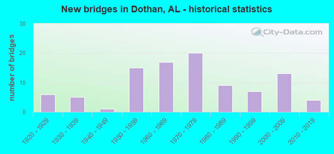
- New bridges - historical statistics
- 61920-1929
- 51930-1939
- 11940-1949
- 151950-1959
- 171960-1969
- 201970-1979
- 91980-1989
- 71990-1999
- 132000-2009
- 42010-2019
FCC Registered Antenna Towers: 544 (See the full list of FCC Registered Antenna Towers)
FCC Registered Commercial Land Mobile Towers: 4 (See the full list of FCC Registered Commercial Land Mobile Towers in Dothan, AL)
FCC Registered Private Land Mobile Towers: 12 (See the full list of FCC Registered Private Land Mobile Towers)
FCC Registered Broadcast Land Mobile Towers: 68 (See the full list of FCC Registered Broadcast Land Mobile Towers)
FCC Registered Microwave Towers: 64 (See the full list of FCC Registered Microwave Towers in this town)
FCC Registered Paging Towers: 11 (See the full list of FCC Registered Paging Towers)
FCC Registered Maritime Coast & Aviation Ground Towers: 10 (See the full list of FCC Registered Maritime Coast & Aviation Ground Towers)
FCC Registered Amateur Radio Licenses: 322 (See the full list of FCC Registered Amateur Radio Licenses in Dothan)
FAA Registered Aircraft: 97 (See the full list of FAA Registered Aircraft in Dothan)
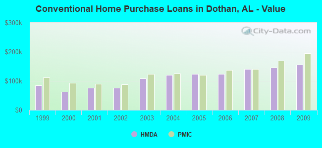
| Home Mortgage Disclosure Act Aggregated Statistics For Year 2009 (Based on 8 full and 9 partial tracts) | ||||||||||||||
| A) FHA, FSA/RHS & VA Home Purchase Loans | B) Conventional Home Purchase Loans | C) Refinancings | D) Home Improvement Loans | E) Loans on Dwellings For 5+ Families | F) Non-occupant Loans on < 5 Family Dwellings (A B C & D) | G) Loans On Manufactured Home Dwelling (A B C & D) | ||||||||
|---|---|---|---|---|---|---|---|---|---|---|---|---|---|---|
| Number | Average Value | Number | Average Value | Number | Average Value | Number | Average Value | Number | Average Value | Number | Average Value | Number | Average Value | |
| LOANS ORIGINATED | 273 | $141,505 | 277 | $155,720 | 1,074 | $153,078 | 80 | $52,891 | 6 | $474,488 | 231 | $106,095 | 18 | $51,231 |
| APPLICATIONS APPROVED, NOT ACCEPTED | 7 | $121,716 | 6 | $69,230 | 60 | $148,379 | 5 | $29,434 | 0 | $0 | 7 | $69,579 | 5 | $34,428 |
| APPLICATIONS DENIED | 29 | $135,848 | 33 | $112,493 | 360 | $118,972 | 65 | $44,483 | 0 | $0 | 23 | $84,633 | 17 | $47,612 |
| APPLICATIONS WITHDRAWN | 39 | $132,009 | 21 | $177,376 | 259 | $145,601 | 3 | $179,660 | 0 | $0 | 11 | $107,212 | 1 | $98,060 |
| FILES CLOSED FOR INCOMPLETENESS | 13 | $117,658 | 3 | $211,073 | 71 | $174,151 | 3 | $78,770 | 0 | $0 | 4 | $123,578 | 0 | $0 |
Detailed mortgage data for all 16 tracts in Dothan, AL
| Private Mortgage Insurance Companies Aggregated Statistics For Year 2009 (Based on 7 full and 9 partial tracts) | ||||||
| A) Conventional Home Purchase Loans | B) Refinancings | C) Non-occupant Loans on < 5 Family Dwellings (A & B) | ||||
|---|---|---|---|---|---|---|
| Number | Average Value | Number | Average Value | Number | Average Value | |
| LOANS ORIGINATED | 30 | $194,456 | 40 | $190,298 | 3 | $110,583 |
| APPLICATIONS APPROVED, NOT ACCEPTED | 9 | $251,744 | 24 | $191,810 | 0 | $0 |
| APPLICATIONS DENIED | 6 | $182,505 | 7 | $215,734 | 0 | $0 |
| APPLICATIONS WITHDRAWN | 0 | $0 | 8 | $201,076 | 2 | $125,000 |
| FILES CLOSED FOR INCOMPLETENESS | 2 | $261,735 | 1 | $265,540 | 1 | $180,000 |
2002 - 2018 National Fire Incident Reporting System (NFIRS) incidents
- Fire incident types reported to NFIRS in Dothan, AL
- 2,71646.9%Outside Fires
- 1,91733.1%Structure Fires
- 96416.7%Mobile Property/Vehicle Fires
- 1913.3%Other
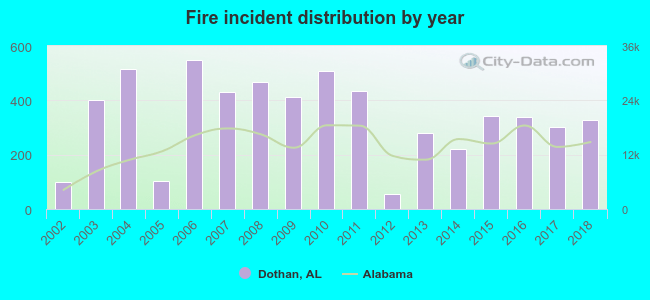 Based on the data from the years 2002 - 2018 the average number of fires per year is 340. The highest number of fire incidents - 550 took place in 2006, and the least - 55 in 2012. The data has a growing trend.
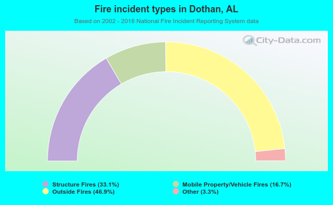 When looking into fire subcategories, the most reports belonged to: Outside Fires (46.9%), and Structure Fires (33.1%).
Fire-safe hotels and motels in Dothan, Alabama:
- Knights Inn, 2841 Ross Clark Cir, Dothan, Alabama 36301 , Phone: (334) 793-2550, Fax: (334) 793-7962
- Quality Inn Dothan, 3053 Ross Clark Cir, Dothan, Alabama 36301 , Phone: (334) 794-6601, Fax: (334) 794-9032
- Best Western Dothan Inn & Suites, 3285 Montgomery Hwy, Dothan, Alabama 36303 , Phone: (334) 793-4376, Fax: (334) 793-7720
- Days Inn Dothan, 3071 Ross Clark Cir, Dothan, Alabama 36301 , Phone: (334) 671-3700, Fax: (334) 702-4102
- Ramada Inn, 3011 Ross Clark Cir, Dothan, Alabama 36301 , Phone: (334) 792-0031, Fax: (334) 794-3134
- Fairfield Inn By Marriott, 3038 Ross Clark Cir, Dothan, Alabama 36301 , Phone: (334) 671-0100, Fax: (334) 671-8608
- Clarion Inn And Suites, 2195 Ross Clark Cir, Dothan, Alabama 36301 , Phone: (334) 794-8711, Fax: (334) 671-3781
- Motel 6, 2903 Ross Clark Cir SW, Dothan, Alabama 36301 , Phone: (334) 793-6013
- 18 other hotels and motels
| Most common first names in Dothan, AL among deceased individuals | ||
| Name | Count | Lived (average) |
|---|---|---|
| James | 584 | 70.4 years |
| Mary | 471 | 77.2 years |
| John | 418 | 73.9 years |
| William | 389 | 72.3 years |
| Willie | 304 | 72.3 years |
| Robert | 253 | 68.6 years |
| Annie | 220 | 78.6 years |
| Charles | 158 | 69.2 years |
| George | 152 | 72.5 years |
| Joseph | 125 | 72.6 years |
| Most common last names in Dothan, AL among deceased individuals | ||
| Last name | Count | Lived (average) |
|---|---|---|
| Smith | 273 | 74.3 years |
| Johnson | 243 | 74.3 years |
| Williams | 206 | 74.8 years |
| Jones | 191 | 72.9 years |
| Brown | 136 | 73.9 years |
| Hall | 135 | 73.9 years |
| Davis | 126 | 74.8 years |
| Jackson | 116 | 72.5 years |
| Thomas | 103 | 73.9 years |
| Martin | 102 | 76.3 years |
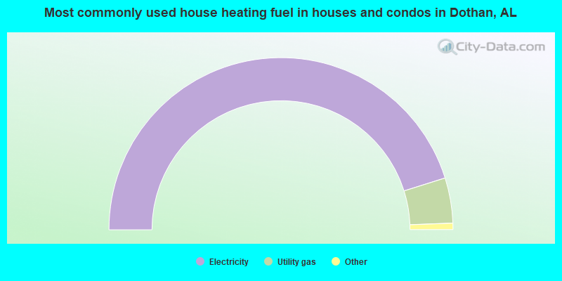
- 90.3%Electricity
- 8.5%Utility gas
- 0.6%Bottled, tank, or LP gas
- 0.3%No fuel used
- 0.1%Wood
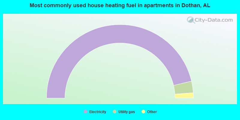
- 92.6%Electricity
- 5.1%Utility gas
- 1.8%No fuel used
- 0.4%Bottled, tank, or LP gas
Dothan compared to Alabama state average:
- Unemployed percentage below state average.
- Median age below state average.
- Length of stay since moving in below state average.
Dothan on our top lists:
- #8 on the list of "Top 101 cities with largest percentage of females in occupations: construction and extraction occupations (population 50,000+)"
- #11 on the list of "Top 101 cities with the lowest number of arson incidents per 100,000 residents (population 50,000+)"
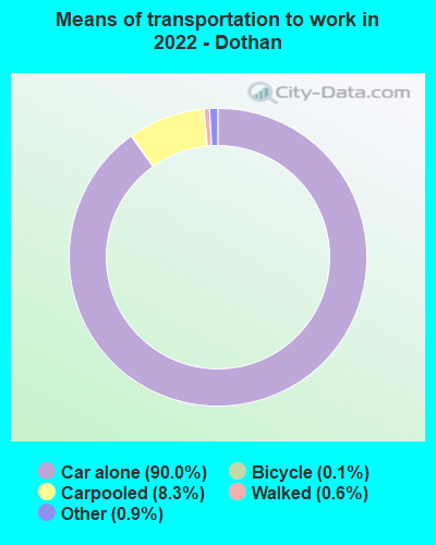
- #11 on the list of "Top 101 cities with the most people driving a car to work alone (population 5,000+)"
- #23 on the list of "Top 101 cities with largest percentage of males in industries: retail trade (population 50,000+)"
- #26 on the list of "Top 101 cities with largest percentage of males in industries: utilities (population 50,000+)"
- #28 on the list of "Top 101 cities with the highest percentage of English-only speaking households, population 50,000+"
- #44 on the list of "Top 101 cities with the highest maximum monthly morning or afternoon humidity (population 50,000+)"
- #48 on the list of "Top 101 cities with the lowest percentage of workers working at home, population 50,000+"
- #50 on the list of "Top 101 cities with largest percentage of males in occupations: health diagnosing and treating practitioners and other technical occupations (population 50,000+)"
- #61 on the list of "Top 101 cities with the highest average yearly precipitation (population 50,000+)"
- #64 on the list of "Top 101 cities with the largest house values disparities (population 50,000+)"
- #74 on the list of "Top 101 cities with largest percentage of males in industries: health care and social assistance (population 50,000+)"
- #74 on the list of "Top 101 cities with largest percentage of females in industries: transportation and warehousing (population 50,000+)"
- #82 on the list of "Top 101 cities with the largest household incomes disparities (population 50,000+)"
- #88 on the list of "Top 101 cities with largest percentage of males in occupations: sales and related occupations (population 50,000+)"
- #90 on the list of "Top 101 cities with the largest percentage of elementary and middle school students in private schools (5,000+ students)"
- #90 on the list of "Top 100 cities with the largest percentage of females (pop. 50,000+)"
- #91 on the list of "Top 101 cities with the highest number of burglaries per 100,000 residents, excludes tourist destinations and others with a lot of outsiders visiting based on city industries data (population 50,000+)"
- #92 on the list of "Top 101 cities with the largest city-data.com crime index increase from 2002 to 2012 (population 50,000+)"

|
|
Total of 49 patent applications in 2008-2024.