Lyme, New York
Submit your own pictures of this town and show them to the world
- OSM Map
- Google Map
- MSN Map
Population change since 2000: +8.4%
 |
| Males: 1,103 | |
| Females: 1,082 |
| Median resident age: | 46.9 years |
| New York median age: | 40.7 years |
Zip codes: 13622.
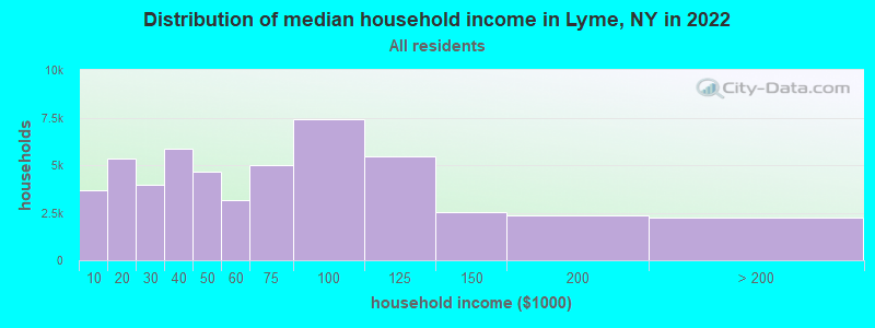
| Lyme: | $62,335 |
| NY: | $79,557 |
Estimated per capita income in 2022: $37,280 (it was $19,522 in 2000)
Lyme town income, earnings, and wages data
Estimated median house or condo value in 2022: $193,561 (it was $72,000 in 2000)
| Lyme: | $193,561 |
| NY: | $400,400 |
Mean prices in 2022: all housing units: $208,656; detached houses: $224,125; townhouses or other attached units: $288,559; in 2-unit structures: $234,918; mobile homes: $87,861
Detailed information about poverty and poor residents in Lyme, NY
Compare current foreclosures near Lyme, NY:
| Photo | Address | Area | Beds / Baths | Price | Details |
|---|---|---|---|---|---|

|
#1
State Pl
Watertown, NY 13601
|
1,608 sq. feet
|
1 baths 4 beds |
$102,500
|
show details |

|
#2
Nys Rt 12f
Dexter, NY 13634
|
1,763 sq. feet
|
2 baths 3 beds |
$225,000
|
show details |

|
#3
Davidson St
Watertown, NY 13601
|
1,664 sq. feet
|
2 baths 3 beds |
show details | |

|
#4
St Lawrence Ave E
Brownville, NY 13615
|
2,723 sq. feet
|
2 baths 6 beds |
show details | |

|
#5
Mill St
Watertown, NY 13601
|
1,660 sq. feet
|
1 baths 3 beds |
show details | |

|
#6
Tilden St
Watertown, NY 13601
|
1,416 sq. feet
|
1 baths 3 beds |
show details | |

|
#7
W Hoard St
Watertown, NY 13601
|
1,208 sq. feet
|
1 baths 3 beds |
show details | |

|
#8
State St
Watertown, NY 13601
|
2,272 sq. feet
|
1 baths 4 beds |
show details | |

|
#9
Gill St
Watertown, NY 13601
|
1,164 sq. feet
|
1 baths 2 beds |
show details | |

|
#10
N Hamilton St
Watertown, NY 13601
|
1,572 sq. feet
|
1 baths 3 beds |
show details |
| Photo | Address | Area | Beds / Baths | Price | Details |
|---|---|---|---|---|---|

|
#11
Burdick St
Watertown, NY 13601
|
774 sq. feet
|
1 baths 2 beds |
show details | |

|
#12
Burchard St
Watertown, NY 13601
|
1,668 sq. feet
|
2 baths 3 beds |
show details | |

|
#13
Hunt St
Watertown, NY 13601
|
1,000 sq. feet
|
1 baths 3 beds |
show details | |

|
#14
Winslow St
Watertown, NY 13601
|
1,958 sq. feet
|
2 baths 4 beds |
show details | |

|
#15
Bishop St
Watertown, NY 13601
|
2,284 sq. feet
|
2 baths 4 beds |
show details | |

|
#16
Shepard St
Watertown, NY 13601
|
1,240 sq. feet
|
1 baths 1 beds |
show details | |

|
#17
County Route 63
Watertown, NY 13601
|
1,614 sq. feet
|
1 baths 3 beds |
show details | |

|
#18
County Route 155
Watertown, NY 13601
|
1,196 sq. feet
|
2 baths 3 beds |
show details | |

|
#19
County Route 76
Adams Center, NY 13606
|
2,128 sq. feet
|
2 baths 3 beds |
show details | |

|
#20
W Lynde St
Watertown, NY 13601
|
1,768 sq. feet
|
2 baths 4 beds |
show details |
| Photo | Address | Area | Beds / Baths | Price | Details |
|---|---|---|---|---|---|

|
#21
Broadway Ave W
Watertown, NY 13601
|
3,021 sq. feet
|
3 baths 7 beds |
show details | |

|
#22
State Route 283
Watertown, NY 13601
|
2,542 sq. feet
|
2 baths 4 beds |
show details | |

|
#23
Portage St
Watertown, NY 13601
|
1,368 sq. feet
|
1 baths 2 beds |
show details | |

|
#24
State Route 12
Watertown, NY 13601
|
616 sq. feet
|
1 baths 2 beds |
show details | |

|
#25
Mustard Rd
Watertown, NY 13601
|
960 sq. feet
|
1 baths 3 beds |
show details | |

|
#26
Main St
Watertown, NY 13601
|
1,546 sq. feet
|
1 baths 4 beds |
show details | |

|
#27
Rivershore Dr
Clayton, NY 13624
|
1,960 sq. feet
|
2 baths 3 beds |
show details | |

|
#28
Wilder Rd
La Fargeville, NY 13656
|
1,637 sq. feet
|
1 baths 3 beds |
show details | |

|
#29
Bellew Ave S
Watertown, NY 13601
|
967 sq. feet
|
1 baths 3 beds |
show details | |

|
#30
State Route 12
Clayton, NY 13624
|
1,120 sq. feet
|
1 baths 3 beds |
show details |
| Photo | Address | Area | Beds / Baths | Price | Details |
|---|---|---|---|---|---|

|
#31
Pelo Rd
Clayton, NY 13624
|
1,801 sq. feet
|
1 baths 5 beds |
show details | |

|
#32
Hazelhurst Ave
Watertown, NY 13601
|
1,548 sq. feet
|
1 baths 3 beds |
show details | |

|
#33
Cady Rd
Adams Center, NY 13606
|
- sq. feet
|
2 baths 3 beds |
show details | |

|
#34
Us Route 11
Adams Center, NY 13606
|
- sq. feet
|
- baths - beds |
show details | |

|
#35
Us Route 11, Lot 73
Calcium, NY 13616
|
- sq. feet
|
- baths - beds |
show details | |

|
#36
N Merlin Loop
Evans Mills, NY 13637
|
- sq. feet
|
- baths - beds |
show details | |

|
#37
Boyd St
Watertown, NY 13601
|
- sq. feet
|
- baths - beds |
show details | |

|
#38
Monroe St
Sackets Harbor, NY 13685
|
- sq. feet
|
- baths - beds |
show details | |

|
#39
Jefferson St
Sackets Harbor, NY 13685
|
- sq. feet
|
- baths - beds |
show details | |

|
#40
State Route 178
Henderson, NY 13650
|
- sq. feet
|
- baths - beds |
show details |
| Photo | Address | Area | Beds / Baths | Price | Details |
|---|---|---|---|---|---|

|
#41
Joseph Lonsway Dr, Apt C
Clayton, NY 13624
|
- sq. feet
|
- baths - beds |
show details | |

|
#42
Redwood Ln Apt E
Watertown, NY 13601
|
- sq. feet
|
- baths - beds |
show details | |

|
#43
Ives St
Watertown, NY 13601
|
- sq. feet
|
- baths - beds |
show details | |

|
#44
Liberty Ave
Watertown, NY 13601
|
- sq. feet
|
- baths - beds |
show details | |

|
#45
N Harbor Rd
Adams Center, NY 13606
|
- sq. feet
|
- baths - beds |
show details | |

|
#46
Keyes Ave
Watertown, NY 13601
|
- sq. feet
|
- baths - beds |
show details | |

|
#47
State St Apt 411
Watertown, NY 13601
|
- sq. feet
|
- baths - beds |
show details | |

|
#48
Palmer St Apt 106
Watertown, NY 13601
|
- sq. feet
|
- baths - beds |
show details | |

|
#49
Court St # 202
Watertown, NY 13601
|
- sq. feet
|
- baths - beds |
show details | |

|
Check over 1 million property listings on Foreclosure.com!
|
browse all offers | |||

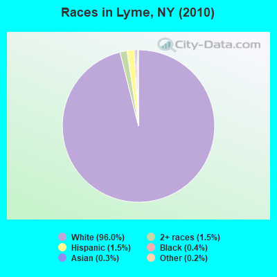
- 2,09896.0%White alone
- 331.5%Two or more races
- 321.5%Hispanic
- 90.4%Black alone
- 60.3%Asian alone
- 50.2%Other race alone
- 20.09%American Indian alone
Races in Lyme detailed stats: ancestries, foreign born residents, place of birth
 Recent articles from our blog. Our writers, many of them Ph.D. graduates or candidates, create easy-to-read articles on a wide variety of topics.
Ancestries: German (20.0%), English (19.8%), Irish (16.5%), French (12.5%), United States (8.6%), Italian (6.6%).
Current Local Time: EST time zone
Land area: 56.1 square miles.
Population density: 39 people per square mile (very low).
22 residents are foreign born
| This town: | 1.1% |
| New York: | 20.4% |
| Lyme town: | 2.0% ($1,442) |
| New York: | 1.9% ($2,847) |
Nearest city with pop. 50,000+: Clay, NY  (63.3 miles , pop. 58,805).
Nearest city with pop. 200,000+: Rochester, NY (95.2 miles , pop. 219,773).
Nearest city with pop. 1,000,000+: Bronx, NY (251.7 miles , pop. 1,332,650).
Nearest cities:
), ), ), ), Latitude: 44.07 N, Longitude: 76.17 W
Area code commonly used in this area: 315
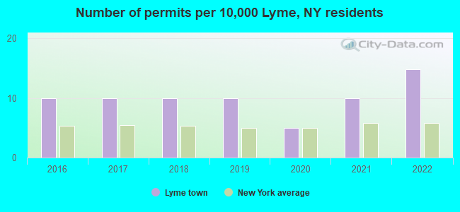
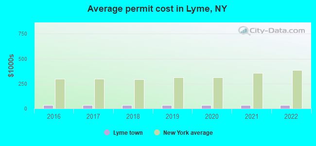
Single-family new house construction building permits:
- 2022: 3 buildings, average cost: $32,000
- 2021: 2 buildings, average cost: $32,000
- 2020: 1 building, cost: $32,000
- 2019: 2 buildings, average cost: $32,000
- 2018: 2 buildings, average cost: $32,000
- 2017: 2 buildings, average cost: $32,000
- 2016: 2 buildings, average cost: $32,000
| Here: | 5.4% |
| New York: | 4.4% |
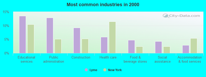
- Educational services (13.5%)
- Public administration (12.9%)
- Construction (9.2%)
- Health care (5.9%)
- Food & beverage stores (4.7%)
- Social assistance (4.3%)
- Accommodation & food services (2.9%)
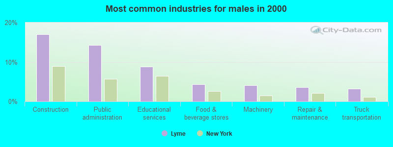
- Construction (17.0%)
- Public administration (14.3%)
- Educational services (8.8%)
- Food & beverage stores (4.3%)
- Machinery (4.1%)
- Repair & maintenance (3.6%)
- Truck transportation (3.2%)
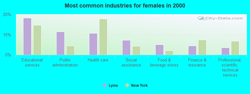
- Educational services (18.3%)
- Public administration (11.5%)
- Health care (10.8%)
- Social assistance (7.3%)
- Food & beverage stores (5.2%)
- Finance & insurance (4.4%)
- Professional, scientific, technical services (3.5%)
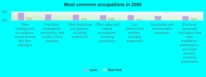
- Other management occupations, except farmers and farm managers (5.6%)
- Preschool, kindergarten, elementary, and middle school teachers (4.4%)
- Other production occupations, including supervisors (4.1%)
- Other sales and related occupations, including supervisors (3.8%)
- Law enforcement workers, including supervisors (3.8%)
- Secretaries and administrative assistants (3.3%)
- Electrical equipment mechanics and other installation, maintenance, and repair workers, including supervisors (3.1%)
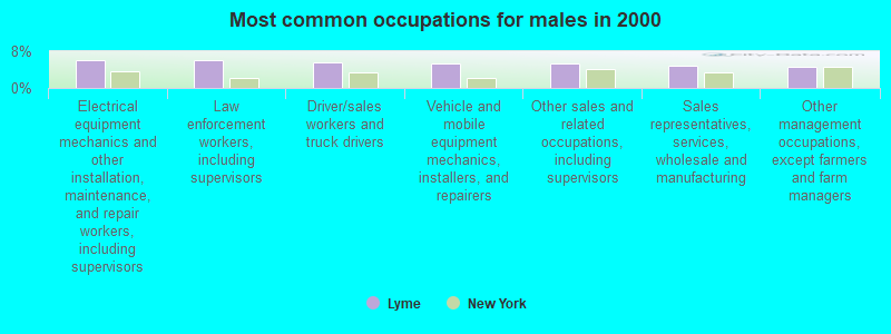
- Electrical equipment mechanics and other installation, maintenance, and repair workers, including supervisors (6.1%)
- Law enforcement workers, including supervisors (6.1%)
- Driver/sales workers and truck drivers (5.7%)
- Vehicle and mobile equipment mechanics, installers, and repairers (5.4%)
- Other sales and related occupations, including supervisors (5.4%)
- Sales representatives, services, wholesale and manufacturing (4.8%)
- Other management occupations, except farmers and farm managers (4.5%)
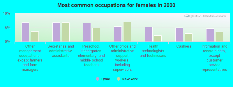
- Other management occupations, except farmers and farm managers (6.8%)
- Secretaries and administrative assistants (6.8%)
- Preschool, kindergarten, elementary, and middle school teachers (6.6%)
- Other office and administrative support workers, including supervisors (5.4%)
- Health technologists and technicians (5.2%)
- Cashiers (4.9%)
- Information and record clerks, except customer service representatives (4.7%)
Average climate in Lyme, New York
Based on data reported by over 4,000 weather stations


Earthquake activity:
Lyme-area historical earthquake activity is significantly above New York state average. It is 71% smaller than the overall U.S. average.On 10/7/1983 at 10:18:46, a magnitude 5.3 (5.1 MB, 5.3 LG, 5.1 ML, Class: Moderate, Intensity: VI - VII) earthquake occurred 91.5 miles away from the city center
On 4/20/2002 at 10:50:47, a magnitude 5.3 (5.3 ML, Depth: 3.0 mi) earthquake occurred 126.4 miles away from Lyme center
On 4/20/2002 at 10:50:47, a magnitude 5.2 (5.2 MB, 4.2 MS, 5.2 MW, 5.0 MW) earthquake occurred 125.1 miles away from Lyme center
On 9/25/1998 at 19:52:52, a magnitude 5.2 (4.8 MB, 4.3 MS, 5.2 LG, 4.5 MW, Depth: 3.1 mi) earthquake occurred 278.6 miles away from Lyme center
On 1/19/1982 at 00:14:42, a magnitude 4.7 (4.5 MB, 4.7 MD, 4.5 LG, Class: Light, Intensity: IV - V) earthquake occurred 231.7 miles away from the city center
On 6/17/1991 at 08:53:16, a magnitude 4.1 (4.0 MB, 4.0 LG, Depth: 3.1 mi) earthquake occurred 124.6 miles away from the city center
Magnitude types: regional Lg-wave magnitude (LG), body-wave magnitude (MB), duration magnitude (MD), local magnitude (ML), surface-wave magnitude (MS), moment magnitude (MW)
Natural disasters:
The number of natural disasters in Jefferson County (16) is near the US average (15).Major Disasters (Presidential) Declared: 7
Emergencies Declared: 7
Causes of natural disasters: Floods: 5, Winter Storms: 4, Snowstorms: 3, Storms: 3, Hurricanes: 2, Winds: 2, Blizzard: 1, Power Outage: 1, Other: 2 (Note: some incidents may be assigned to more than one category).
Hospitals and medical centers near Lyme:
- JEFFERSON REHAB CENTER, NYSARC, INC (Hospital, about 8 miles away; DEXTER, NY)
- JEFFERSON REHAB CENTER, NYSARC, INC (Hospital, about 13 miles away; WATERTOWN, NY)
- JEFFERSON CO PUB HLTH SVS CHHA (Home Health Center, about 14 miles away; WATERTOWN, NY)
- MERCY OF NORTHERN NEW YORK (Nursing Home, about 15 miles away; WATERTOWN, NY)
- HOSPICE OF JEFFERSON COUNTY INC (Hospital, about 15 miles away; WATERTOWN, NY)
- SAMARITAN KEEP NURSING HOME INC (Nursing Home, about 15 miles away; WATERTOWN, NY)
- SAMARITAN MEDICAL CENTER Acute Care Hospitals (about 15 miles away; WATERTOWN, NY)
Colleges/universities with over 2000 students nearest to Lyme:
- Jefferson Community College (about 13 miles; Watertown, NY; Full-time enrollment: 2,886)
- SUNY College at Oswego (about 47 miles; Oswego, NY; FT enrollment: 7,550)
- SUNY College of Technology at Canton (about 62 miles; Canton, NY; FT enrollment: 3,411)
- St Lawrence University (about 62 miles; Canton, NY; FT enrollment: 2,501)
- Le Moyne College (about 71 miles; Syracuse, NY; FT enrollment: 3,041)
- Syracuse University (about 71 miles; Syracuse, NY; FT enrollment: 20,717)
- Clarkson University (about 72 miles; Potsdam, NY; FT enrollment: 3,472)
Points of interest:
Notable locations in Lyme: The Last Resort (A), Cresent Yacht Club (B), Chaumont Harbor Light (C), Bourey Marina (D), Hamilton Marina (E), Cresent Marina (F), Bay Breeze Golf Links (G), Bar Z Farm (H), Lyme Free Library (I), Three Mile Bay Fire Hall (J), Chaumont Fire Department (K). Display/hide their locations on the map
Churches in Lyme include: All Saints Church (A), Victory Community Church (B). Display/hide their locations on the map
Cemeteries: Putman Cemetery (1), Wells Cemetery (2), Fox Creek Cemetery (3), Barnes Bay Cemetery (4), Harder Cemetery (5), Harris Cemetery (6), Point Peninsula Cemetery (7). Display/hide their locations on the map
Rivers and creeks: Guffin Creek (A), Soper Creek (B), Three Mile Creek (C), Chaumont River (D), Shaver Creek (E), Horse Creek (F). Display/hide their locations on the map
Park in Lyme: Long Point State Park (1). Display/hide its location on the map
Beach: North Shore (A). Display/hide its location on the map
| This town: | 2.4 people |
| New York: | 2.6 people |
| This town: | 70.5% |
| Whole state: | 63.5% |
| This town: | 7.1% |
| Whole state: | 6.8% |
Likely homosexual households (counted as self-reported same-sex unmarried-partner households)
- Lesbian couples: 0.4% of all households
- Gay men: 0.8% of all households
| This town: | 10.2% |
| Whole state: | 14.6% |
| This town: | 2.5% |
| Whole state: | 7.4% |
13 people in homes for the mentally retarded in 2000
For population 15 years and over in Lyme:
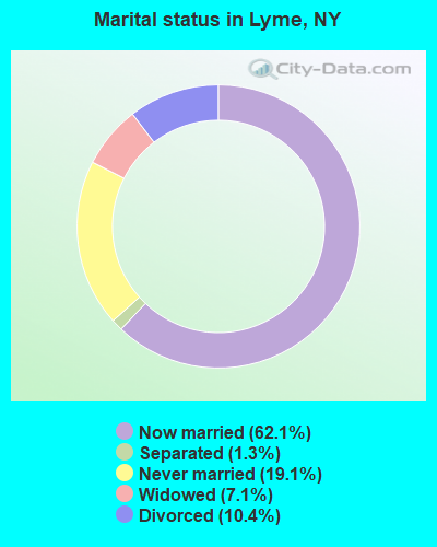
- Never married: 19.1%
- Now married: 62.1%
- Separated: 1.3%
- Widowed: 7.1%
- Divorced: 10.4%
For population 25 years and over in Lyme:
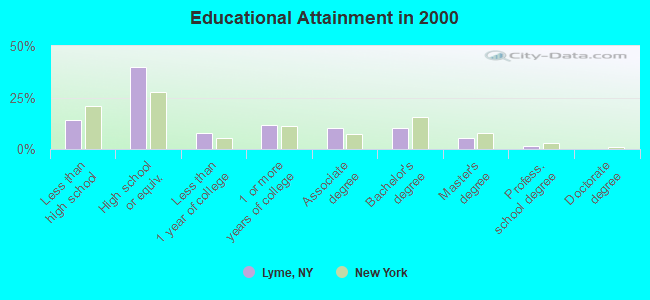
- High school or higher: 86.1%
- Bachelor's degree or higher: 16.9%
- Graduate or professional degree: 6.6%
- Unemployed: 7.4%
- Mean travel time to work (commute): 26.8 minutes
| Here: | 10.0 |
| New York average: | 14.2 |
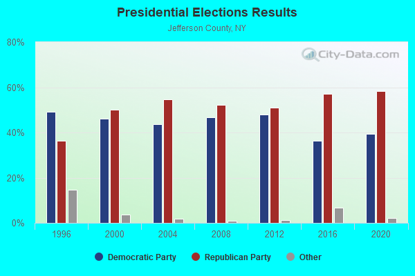
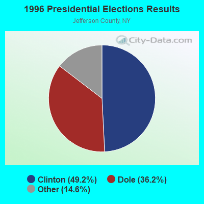
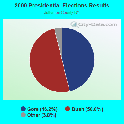
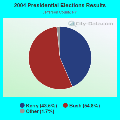
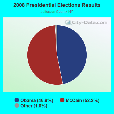
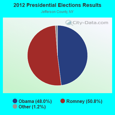
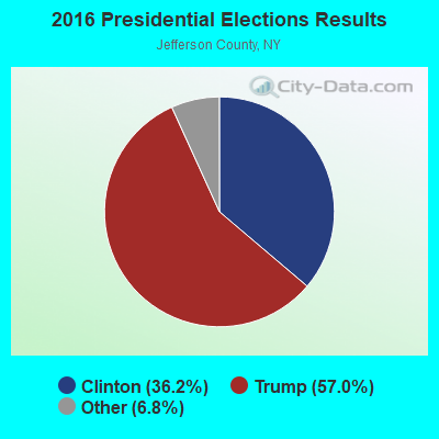
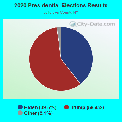
Graphs represent county-level data. Detailed 2008 Election Results
Religion statistics for Lyme, NY (based on Jefferson County data)
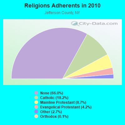
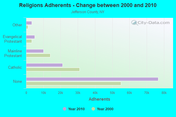
| Religion | Adherents | Congregations |
|---|---|---|
| Catholic | 21,194 | 23 |
| Mainline Protestant | 10,124 | 73 |
| Evangelical Protestant | 4,888 | 43 |
| Other | 3,176 | 8 |
| Orthodox | 140 | 1 |
| Black Protestant | 16 | 1 |
| None | 76,691 | - |
Food Environment Statistics:
| Here: | 2.37 / 10,000 pop. |
| New York: | 4.13 / 10,000 pop. |
| This county: | 0.08 / 10,000 pop. |
| State: | 0.06 / 10,000 pop. |
| Here: | 0.59 / 10,000 pop. |
| New York: | 0.92 / 10,000 pop. |
| Jefferson County: | 4.49 / 10,000 pop. |
| New York: | 1.68 / 10,000 pop. |
| Jefferson County: | 9.84 / 10,000 pop. |
| New York: | 8.82 / 10,000 pop. |
| Jefferson County: | 7.3% |
| New York: | 8.2% |
| Jefferson County: | 28.0% |
| State: | 23.8% |
| Jefferson County: | 10.1% |
| New York: | 15.6% |
10.06% of this county's 2021 resident taxpayers lived in other counties in 2020 ($48,837 average adjusted gross income)
| Here: | 10.06% |
| New York average: | 5.29% |
0.47% of residents moved from foreign countries ($2,248 average AGI)
Jefferson County: 0.47% New York average: 0.01%
Top counties from which taxpayers relocated into this county between 2020 and 2021:
| from St. Lawrence County, NY | |
| from Lewis County, NY | |
| from Oswego County, NY |
10.90% of this county's 2020 resident taxpayers moved to other counties in 2021 ($49,016 average adjusted gross income)
| Here: | 10.90% |
| New York average: | 6.93% |
0.34% of residents moved to foreign countries ($1,564 average AGI)
Jefferson County: 0.34% New York average: 0.02%
Top counties to which taxpayers relocated from this county between 2020 and 2021:
| to Lewis County, NY | |
| to St. Lawrence County, NY | |
| to Onondaga County, NY |
Strongest AM radio stations in Lyme:
- WNER (1410 AM; 5 kW; WATERTOWN, NY)
- WTNY (790 AM; 1 kW; WATERTOWN, NY; Owner: REGENT LICENSEE OF WATERTOWN, INC.)
- WATN (1240 AM; 1 kW; WATERTOWN, NY; Owner: CLANCY-MANCE COMMUNICATIONS, INC)
- WHAM (1180 AM; 50 kW; ROCHESTER, NY; Owner: CITICASTERS LICENSES, L.P.)
- WGY (810 AM; 50 kW; SCHENECTADY, NY; Owner: CLEAR CHANNEL BROADCASTING LICENSES, INC.)
- WICY (1490 AM; 50 kW; MALONE, NY; Owner: CARTIER COMMUNICATIONS INC.)
- WSCP (1070 AM; daytime; 2 kW; SANDY CREEK-PULASKI, NY; Owner: GALAXY COMMUNICATIONS, L.P.)
- WCHP (760 AM; 35 kW; CHAMPLAIN, NY; Owner: CHAMPLAIN RADIO, INC.)
- WHEN (620 AM; 5 kW; SYRACUSE, NY; Owner: CLEAR CHANNEL BROADCASTING LICENSES, INC.)
- WNNZ (640 AM; 50 kW; WESTFIELD, MA; Owner: CLEAR CHANNEL BROADCASTING LICENSES, INC.)
- WPTR (1540 AM; 50 kW; ALBANY, NY; Owner: KIMTRON, INC.)
- WSYR (570 AM; 5 kW; SYRACUSE, NY; Owner: CLEAR CHANNEL BROADCASTING LICENSES, INC.)
- WWKB (1520 AM; 50 kW; BUFFALO, NY; Owner: ENTERCOM BUFFALO LICENSE, LLC)
Strongest FM radio stations in Lyme:
- WMHI (94.7 FM; CAPE VINCENT, NY; Owner: MARS HILL BROADCASTING COMPANY INC)
- WFRY-FM (97.5 FM; WATERTOWN, NY; Owner: REGENT LICENSEE OF WATERTOWN, INC.)
- WBDR (102.7 FM; CAPE VINCENT, NY; Owner: BORDER INTERNATIONAL BROADCASTING, I)
- WBDI (106.7 FM; COPENHAGEN, NY; Owner: FORCE COMMUNICATIONS, INC)
- WJNY (90.9 FM; WATERTOWN, NY; Owner: PUBLIC B/CNG COUNCIL CENTRAL NY, INC)
- WCIZ-FM (93.3 FM; WATERTOWN, NY; Owner: REGENT LICENSEE OF WATERTOWN, INC.)
- WRVJ (91.7 FM; WATERTOWN, NY; Owner: STATE UNIVERSITY OF NEW YORK)
- WSLJ (88.9 FM; WATERTOWN, NY; Owner: THE ST. LAWRENCE UNIVERSITY)
- WTOJ (103.1 FM; CARTHAGE, NY; Owner: CLANCY-MANCE COMMUNICATIONS, INC.)
- WWJS (90.1 FM; WATERTOWN, NY; Owner: LIBERTY COMMUNICATIONS FAMILY B/G)
- WOTT (100.7 FM; HENDERSON, NY; Owner: JEFFERSON BROADCASTING, INC.)
TV broadcast stations around Lyme:
- WWTI (Channel 50; WATERTOWN, NY; Owner: CENTRAL NY NEWS, INC.)
- WBQZ-LP (Channel 34; WATERTOWN, NY; Owner: ANTHONY DiMARCANTONIO)
- WLOT-LP (Channel 66; WATERTOWN, NY; Owner: R. ANTHONY DiMARCANTONIO)
- WPBS-TV (Channel 16; WATERTOWN, NY; Owner: ST. LAWRENCE VALLEY EDUCATIONAL TV COUNCIL, INC)
- WWNY-TV (Channel 7; CARTHAGE, NY; Owner: UNITED COMMUNICATIONS CORPORATION)
- WNYF-CA (Channel 25; WATERTOWN, NY; Owner: UNITED COMMUNICATIONS CORPORATION)
- National Bridge Inventory (NBI) Statistics
- 4Number of bridges
- 10ft / 3.5mTotal length
- $1,239,000Total costs
- 6,233Total average daily traffic
- 640Total average daily truck traffic
- 6,628Total future (year 2035) average daily traffic
FCC Registered Cell Phone Towers:
1- Chaumont Cell Site: Morris Track Road (Lat: 44.065889 Lon: -76.119389), Structure height: 57.6 m, Call Sign: KNKN766
Assigned Frequencies: 880.020 MHz, 891.510 MHz, 835.020 MHz, 846.510 MHzGrant Date: 09/01/2020, Expiration Date: 10/01/2030Registrant: Verizon Wireless, 5055 North Point Pkwy, Np2ne Network Engineering, Alpharetta, GA 30022, Phone: (770) 797-1070, Fax: (770) 797-1036, Email:
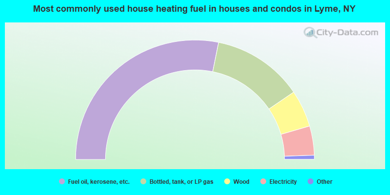
- 56.3%Fuel oil, kerosene, etc.
- 24.6%Bottled, tank, or LP gas
- 10.0%Wood
- 7.9%Electricity
- 0.7%Utility gas
- 0.4%Coal or coke
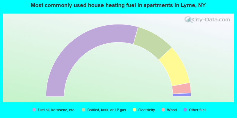
- 58.8%Fuel oil, kerosene, etc.
- 17.6%Bottled, tank, or LP gas
- 17.6%Electricity
- 4.6%Wood
- 1.5%Other fuel
Lyme compared to New York state average:
- Median house value below state average.
- Unemployed percentage below state average.
- Black race population percentage significantly below state average.
- Hispanic race population percentage significantly below state average.
- Median age above state average.
- Foreign-born population percentage significantly below state average.
- Renting percentage significantly below state average.
- Length of stay since moving in significantly above state average.
- Number of rooms per house significantly below state average.
- House age significantly below state average.
- Number of college students below state average.
- Percentage of population with a bachelor's degree or higher below state average.