Hounsfield, New York
Submit your own pictures of this town and show them to the world
- OSM Map
- Google Map
- MSN Map
Population change since 2000: +4.3%
 |
| Males: 1,702 | |
| Females: 1,764 |
| Median resident age: | 40.3 years |
| New York median age: | 40.7 years |
Zip codes: 13601.
| Hounsfield: | $69,705 |
| NY: | $79,557 |
Estimated per capita income in 2022: $37,822 (it was $19,806 in 2000)
Hounsfield town income, earnings, and wages data
Estimated median house or condo value in 2022: $197,056 (it was $73,300 in 2000)
| Hounsfield: | $197,056 |
| NY: | $400,400 |
Mean prices in 2022: all housing units: $208,656; detached houses: $224,125; townhouses or other attached units: $288,559; in 2-unit structures: $234,918; mobile homes: $87,861
Detailed information about poverty and poor residents in Hounsfield, NY


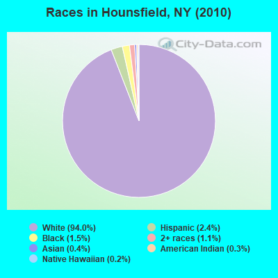
- 3,25894.0%White alone
- 842.4%Hispanic
- 521.5%Black alone
- 381.1%Two or more races
- 150.4%Asian alone
- 110.3%American Indian alone
- 70.2%Native Hawaiian and Other
Pacific Islander alone - 10.03%Other race alone
Races in Hounsfield detailed stats: ancestries, foreign born residents, place of birth
 Recent articles from our blog. Our writers, many of them Ph.D. graduates or candidates, create easy-to-read articles on a wide variety of topics.
Ancestries: Irish (22.3%), English (19.4%), German (16.7%), French (10.2%), Italian (8.8%), French Canadian (6.2%).
Current Local Time: EST time zone
Land area: 49.3 square miles.
Population density: 70 people per square mile (very low).
86 residents are foreign born (0.9% Europe, 0.6% North America, 0.6% Asia, 0.5% Latin America).
| This town: | 2.6% |
| New York: | 20.4% |
| Hounsfield town: | 2.4% ($1,725) |
| New York: | 1.9% ($2,847) |
Nearest city with pop. 50,000+: Clay, NY  (55.3 miles , pop. 58,805).
Nearest city with pop. 200,000+: Rochester, NY (93.9 miles , pop. 219,773).
Nearest city with pop. 1,000,000+: Bronx, NY (242.2 miles , pop. 1,332,650).
Nearest cities:
), ), ), Latitude: 43.95 N, Longitude: 76.08 W
Area code commonly used in this area: 315
| Here: | 5.4% |
| New York: | 4.4% |
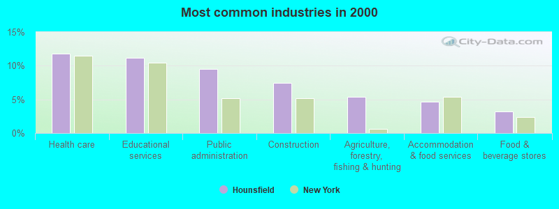
- Health care (11.8%)
- Educational services (11.2%)
- Public administration (9.5%)
- Construction (7.5%)
- Agriculture, forestry, fishing & hunting (5.4%)
- Accommodation & food services (4.7%)
- Food & beverage stores (3.2%)
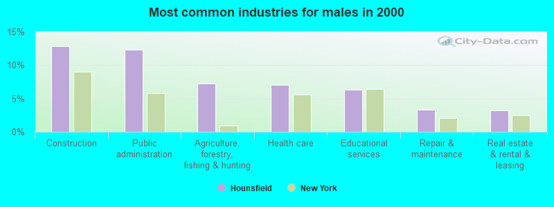
- Construction (12.9%)
- Public administration (12.3%)
- Agriculture, forestry, fishing & hunting (7.3%)
- Health care (7.0%)
- Educational services (6.3%)
- Repair & maintenance (3.3%)
- Real estate & rental & leasing (3.2%)
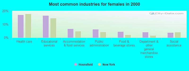
- Health care (17.2%)
- Educational services (16.7%)
- Accommodation & food services (6.7%)
- Public administration (6.5%)
- Food & beverage stores (4.6%)
- Department & other general merchandise stores (4.3%)
- Social assistance (3.9%)
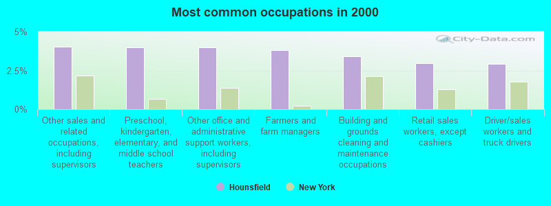
- Other sales and related occupations, including supervisors (4.0%)
- Preschool, kindergarten, elementary, and middle school teachers (4.0%)
- Other office and administrative support workers, including supervisors (4.0%)
- Farmers and farm managers (3.8%)
- Building and grounds cleaning and maintenance occupations (3.4%)
- Retail sales workers, except cashiers (3.0%)
- Driver/sales workers and truck drivers (2.9%)
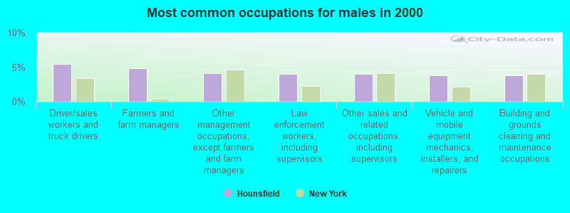
- Driver/sales workers and truck drivers (5.5%)
- Farmers and farm managers (4.9%)
- Other management occupations, except farmers and farm managers (4.2%)
- Law enforcement workers, including supervisors (4.1%)
- Other sales and related occupations, including supervisors (4.1%)
- Vehicle and mobile equipment mechanics, installers, and repairers (3.8%)
- Building and grounds cleaning and maintenance occupations (3.8%)
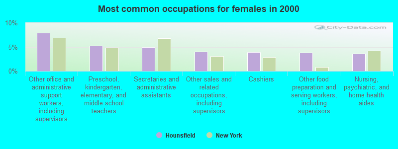
- Other office and administrative support workers, including supervisors (7.9%)
- Preschool, kindergarten, elementary, and middle school teachers (5.2%)
- Secretaries and administrative assistants (5.0%)
- Other sales and related occupations, including supervisors (4.0%)
- Cashiers (3.9%)
- Other food preparation and serving workers, including supervisors (3.8%)
- Nursing, psychiatric, and home health aides (3.6%)
Average climate in Hounsfield, New York
Based on data reported by over 4,000 weather stations


Earthquake activity:
Hounsfield-area historical earthquake activity is significantly above New York state average. It is 70% smaller than the overall U.S. average.On 10/7/1983 at 10:18:46, a magnitude 5.3 (5.1 MB, 5.3 LG, 5.1 ML, Class: Moderate, Intensity: VI - VII) earthquake occurred 86.5 miles away from Hounsfield center
On 4/20/2002 at 10:50:47, a magnitude 5.3 (5.3 ML, Depth: 3.0 mi) earthquake occurred 124.4 miles away from the city center
On 4/20/2002 at 10:50:47, a magnitude 5.2 (5.2 MB, 4.2 MS, 5.2 MW, 5.0 MW) earthquake occurred 122.9 miles away from the city center
On 9/25/1998 at 19:52:52, a magnitude 5.2 (4.8 MB, 4.3 MS, 5.2 LG, 4.5 MW, Depth: 3.1 mi) earthquake occurred 277.3 miles away from the city center
On 1/19/1982 at 00:14:42, a magnitude 4.7 (4.5 MB, 4.7 MD, 4.5 LG, Class: Light, Intensity: IV - V) earthquake occurred 226.0 miles away from Hounsfield center
On 6/17/1991 at 08:53:16, a magnitude 4.1 (4.0 MB, 4.0 LG, Depth: 3.1 mi) earthquake occurred 115.2 miles away from the city center
Magnitude types: regional Lg-wave magnitude (LG), body-wave magnitude (MB), duration magnitude (MD), local magnitude (ML), surface-wave magnitude (MS), moment magnitude (MW)
Natural disasters:
The number of natural disasters in Jefferson County (16) is near the US average (15).Major Disasters (Presidential) Declared: 7
Emergencies Declared: 7
Causes of natural disasters: Floods: 5, Winter Storms: 4, Snowstorms: 3, Storms: 3, Hurricanes: 2, Winds: 2, Blizzard: 1, Power Outage: 1, Other: 2 (Note: some incidents may be assigned to more than one category).
Hospitals and medical centers near Hounsfield:
- JEFFERSON REHAB CENTER, NYSARC, INC (Hospital, about 5 miles away; DEXTER, NY)
- JEFFERSON REHAB CENTER, NYSARC, INC (Hospital, about 8 miles away; WATERTOWN, NY)
- RENAL CARE OF NORTHERN NEW YORK, LLC (Dialysis Facility, about 9 miles away; WATERTOWN, NY)
- SAMARITAN KEEP NURSING HOME INC (Nursing Home, about 9 miles away; WATERTOWN, NY)
- MERCY OF NORTHERN NEW YORK (Nursing Home, about 9 miles away; WATERTOWN, NY)
- SAMARITAN MEDICAL CENTER Acute Care Hospitals (about 9 miles away; WATERTOWN, NY)
- JEFFERSON CO PUB HLTH SVS CHHA (Home Health Center, about 9 miles away; WATERTOWN, NY)
Colleges/universities with over 2000 students nearest to Hounsfield:
- Jefferson Community College (about 8 miles; Watertown, NY; Full-time enrollment: 2,886)
- SUNY College at Oswego (about 42 miles; Oswego, NY; FT enrollment: 7,550)
- Le Moyne College (about 63 miles; Syracuse, NY; FT enrollment: 3,041)
- Syracuse University (about 63 miles; Syracuse, NY; FT enrollment: 20,717)
- SUNY College of Environmental Science and Forestry (about 64 miles; Syracuse, NY; FT enrollment: 2,044)
- St Lawrence University (about 64 miles; Canton, NY; FT enrollment: 2,501)
- SUNY College of Technology at Canton (about 64 miles; Canton, NY; FT enrollment: 3,411)
Points of interest:
Notable locations in Hounsfield: Grunerts Marina (A), Madison Park (B), Stowell Corners (C), Maxon Corners (D), Sackets Harbor Light (E), Bedford Creek Golf Course (F), Bedford Creek Campground (G), Allens Marina Campground (H), Sackets Harbor Town Dock (I), Sackets Harbor Sewage Treatment Plant (J), Hay Memorial Library (K), Sackets Harbor Fire Station (L). Display/hide their locations on the map
Churches in Hounsfield include: Christ Episcopal Church (A), Saint Andrews Catholic Church (B), United Presbyterian Church (C), Watertown Seventh Day Adventist Church (D). Display/hide their locations on the map
Cemeteries: Muskalonge Cemetery (1), Fields Settlement Cemetery (2), Military Cemetery (3). Display/hide their locations on the map
Swamps: Beaver Meadows (A). Display/hide its location on the map
Rivers and creeks: Black River (A), Bedford Creek (B), Muskellunge Creek (C), Mill Creek (D). Display/hide their locations on the map
Parks in Hounsfield include: Market Square Park (1), Sackets Harbor Battlefield State Park (2). Display/hide their locations on the map
| This town: | 2.4 people |
| New York: | 2.6 people |
| This town: | 64.5% |
| Whole state: | 63.5% |
| This town: | 7.9% |
| Whole state: | 6.8% |
Likely homosexual households (counted as self-reported same-sex unmarried-partner households)
- Lesbian couples: 0.3% of all households
- Gay men: 0.8% of all households
| This town: | 10.6% |
| Whole state: | 14.6% |
| This town: | 3.3% |
| Whole state: | 7.4% |
8 people in homes for the mentally retarded in 2000
For population 15 years and over in Hounsfield:
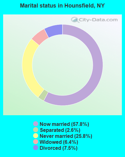
- Never married: 25.8%
- Now married: 57.8%
- Separated: 2.6%
- Widowed: 6.4%
- Divorced: 7.5%
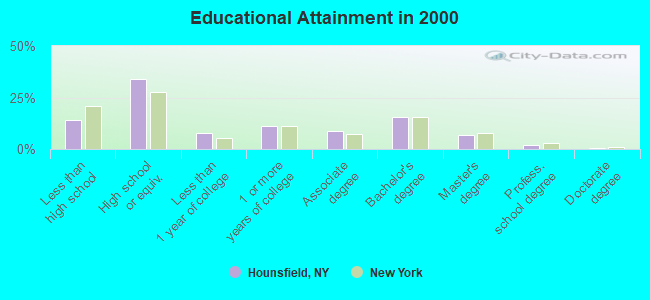
For population 25 years and over in Hounsfield:
- High school or higher: 86.0%
- Bachelor's degree or higher: 24.5%
- Graduate or professional degree: 8.8%
- Unemployed: 7.2%
- Mean travel time to work (commute): 20.2 minutes
| Here: | 10.9 |
| New York average: | 14.2 |
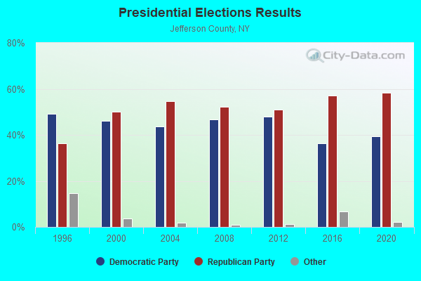
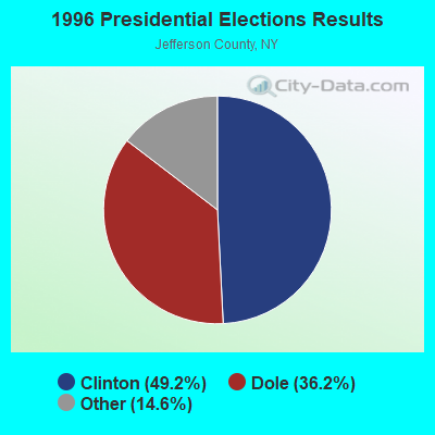
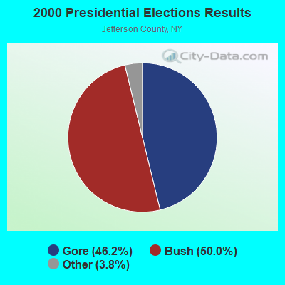
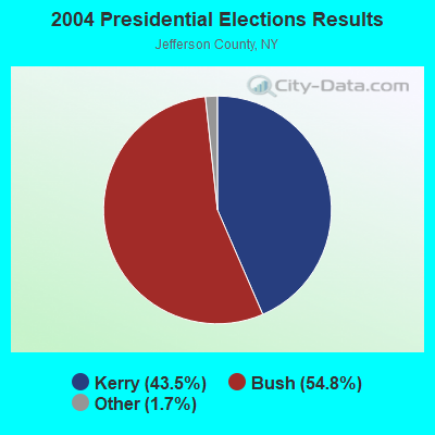
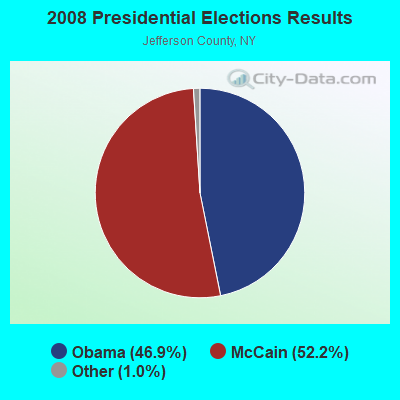
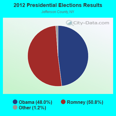
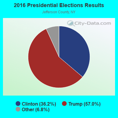
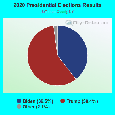
Graphs represent county-level data. Detailed 2008 Election Results
Religion statistics for Hounsfield, NY (based on Jefferson County data)
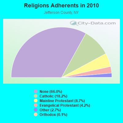
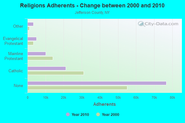
| Religion | Adherents | Congregations |
|---|---|---|
| Catholic | 21,194 | 23 |
| Mainline Protestant | 10,124 | 73 |
| Evangelical Protestant | 4,888 | 43 |
| Other | 3,176 | 8 |
| Orthodox | 140 | 1 |
| Black Protestant | 16 | 1 |
| None | 76,691 | - |
Food Environment Statistics:
| Jefferson County: | 2.37 / 10,000 pop. |
| New York: | 4.13 / 10,000 pop. |
| Jefferson County: | 0.08 / 10,000 pop. |
| State: | 0.06 / 10,000 pop. |
| This county: | 0.59 / 10,000 pop. |
| New York: | 0.92 / 10,000 pop. |
| This county: | 4.49 / 10,000 pop. |
| State: | 1.68 / 10,000 pop. |
| Jefferson County: | 9.84 / 10,000 pop. |
| New York: | 8.82 / 10,000 pop. |
| This county: | 7.3% |
| New York: | 8.2% |
| This county: | 28.0% |
| New York: | 23.8% |
| Jefferson County: | 10.1% |
| New York: | 15.6% |
10.06% of this county's 2021 resident taxpayers lived in other counties in 2020 ($48,837 average adjusted gross income)
| Here: | 10.06% |
| New York average: | 5.29% |
0.47% of residents moved from foreign countries ($2,248 average AGI)
Jefferson County: 0.47% New York average: 0.01%
Top counties from which taxpayers relocated into this county between 2020 and 2021:
| from St. Lawrence County, NY | |
| from Lewis County, NY | |
| from Oswego County, NY |
10.90% of this county's 2020 resident taxpayers moved to other counties in 2021 ($49,016 average adjusted gross income)
| Here: | 10.90% |
| New York average: | 6.93% |
0.34% of residents moved to foreign countries ($1,564 average AGI)
Jefferson County: 0.34% New York average: 0.02%
Top counties to which taxpayers relocated from this county between 2020 and 2021:
| to Lewis County, NY | |
| to St. Lawrence County, NY | |
| to Onondaga County, NY |
Strongest AM radio stations in Hounsfield:
- WNER (1410 AM; 5 kW; WATERTOWN, NY)
- WTNY (790 AM; 1 kW; WATERTOWN, NY; Owner: REGENT LICENSEE OF WATERTOWN, INC.)
- WATN (1240 AM; 1 kW; WATERTOWN, NY; Owner: CLANCY-MANCE COMMUNICATIONS, INC)
- WSCP (1070 AM; daytime; 2 kW; SANDY CREEK-PULASKI, NY; Owner: GALAXY COMMUNICATIONS, L.P.)
- WHAM (1180 AM; 50 kW; ROCHESTER, NY; Owner: CITICASTERS LICENSES, L.P.)
- WGY (810 AM; 50 kW; SCHENECTADY, NY; Owner: CLEAR CHANNEL BROADCASTING LICENSES, INC.)
- WICY (1490 AM; 50 kW; MALONE, NY; Owner: CARTIER COMMUNICATIONS INC.)
- WHEN (620 AM; 5 kW; SYRACUSE, NY; Owner: CLEAR CHANNEL BROADCASTING LICENSES, INC.)
- WCHP (760 AM; 35 kW; CHAMPLAIN, NY; Owner: CHAMPLAIN RADIO, INC.)
- WSYR (570 AM; 5 kW; SYRACUSE, NY; Owner: CLEAR CHANNEL BROADCASTING LICENSES, INC.)
- WPTR (1540 AM; 50 kW; ALBANY, NY; Owner: KIMTRON, INC.)
- WNNZ (640 AM; 50 kW; WESTFIELD, MA; Owner: CLEAR CHANNEL BROADCASTING LICENSES, INC.)
- WMCA (570 AM; 50 kW; NEW YORK, NY; Owner: SALEM MEDIA OF NEW YORK, LLC)
Strongest FM radio stations in Hounsfield:
- WFRY-FM (97.5 FM; WATERTOWN, NY; Owner: REGENT LICENSEE OF WATERTOWN, INC.)
- WRVJ (91.7 FM; WATERTOWN, NY; Owner: STATE UNIVERSITY OF NEW YORK)
- WBDI (106.7 FM; COPENHAGEN, NY; Owner: FORCE COMMUNICATIONS, INC)
- WJNY (90.9 FM; WATERTOWN, NY; Owner: PUBLIC B/CNG COUNCIL CENTRAL NY, INC)
- WOTT (100.7 FM; HENDERSON, NY; Owner: JEFFERSON BROADCASTING, INC.)
- WSLJ (88.9 FM; WATERTOWN, NY; Owner: THE ST. LAWRENCE UNIVERSITY)
- WCIZ-FM (93.3 FM; WATERTOWN, NY; Owner: REGENT LICENSEE OF WATERTOWN, INC.)
- WTOJ (103.1 FM; CARTHAGE, NY; Owner: CLANCY-MANCE COMMUNICATIONS, INC.)
- WWJS (90.1 FM; WATERTOWN, NY; Owner: LIBERTY COMMUNICATIONS FAMILY B/G)
- WMHI (94.7 FM; CAPE VINCENT, NY; Owner: MARS HILL BROADCASTING COMPANY INC)
- WBDR (102.7 FM; CAPE VINCENT, NY; Owner: BORDER INTERNATIONAL BROADCASTING, I)
- WLLG (99.3 FM; LOWVILLE, NY; Owner: THE FLACK BROADCASTING GROUP L.L.C.)
- WSCP-FM (101.7 FM; PULASKI, NY; Owner: GALAXY COMMUNICATIONS, L.P.)
- W281AA (104.1 FM; WATERTOWN, NY; Owner: CLANCY - MANCE COMMUNICATIONS, INC.)
TV broadcast stations around Hounsfield:
- WWTI (Channel 50; WATERTOWN, NY; Owner: CENTRAL NY NEWS, INC.)
- WPBS-TV (Channel 16; WATERTOWN, NY; Owner: ST. LAWRENCE VALLEY EDUCATIONAL TV COUNCIL, INC)
- WWNY-TV (Channel 7; CARTHAGE, NY; Owner: UNITED COMMUNICATIONS CORPORATION)
- WBQZ-LP (Channel 34; WATERTOWN, NY; Owner: ANTHONY DiMARCANTONIO)
- WLOT-LP (Channel 66; WATERTOWN, NY; Owner: R. ANTHONY DiMARCANTONIO)
- WSPX-TV (Channel 56; SYRACUSE, NY; Owner: PAXSON SYRACUSE LICENSE, INC.)
- WNYF-CA (Channel 25; WATERTOWN, NY; Owner: UNITED COMMUNICATIONS CORPORATION)
- National Bridge Inventory (NBI) Statistics
- 14Number of bridges
- 69ft / 21.5mTotal length
- $12,258,000Total costs
- 31,292Total average daily traffic
- 3,590Total average daily truck traffic
- 38,136Total future (year 2036) average daily traffic
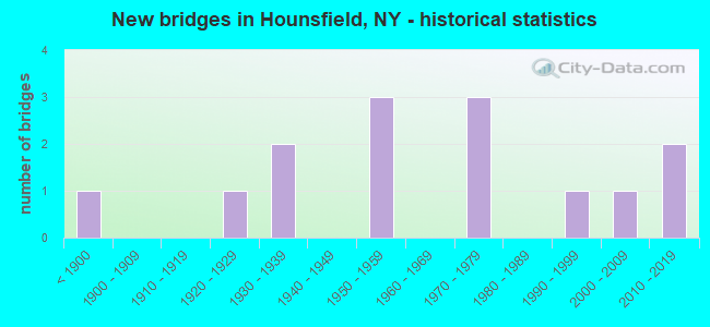
- New bridges - historical statistics
- 1Before 1900
- 11920-1929
- 21930-1939
- 31950-1959
- 31970-1979
- 11990-1999
- 12000-2009
- 22010-2019
FCC Registered Paging Towers:
1- 8.83 Mi Wnw Of Henderson, New York (Lat: 43.882833 Lon: -76.352417), Call Sign: WDZ788,
Assigned Frequencies: 459.550 MHz, Expiration Date: 11/01/1998, Cancellation Date: 10/26/1999, Registrant: Contel Of New York, Inc., 850 Harrison St., Johnstown, NY 12095
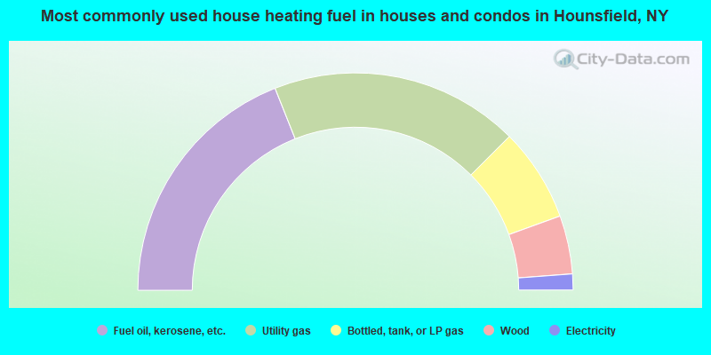
- 38.0%Fuel oil, kerosene, etc.
- 37.1%Utility gas
- 13.9%Bottled, tank, or LP gas
- 8.7%Wood
- 2.4%Electricity
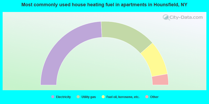
- 48.3%Electricity
- 28.7%Utility gas
- 17.4%Fuel oil, kerosene, etc.
- 3.1%Bottled, tank, or LP gas
- 1.6%Wood
- 0.9%Other fuel
Hounsfield compared to New York state average:
- Median house value below state average.
- Unemployed percentage below state average.
- Black race population percentage significantly below state average.
- Hispanic race population percentage significantly below state average.
- Foreign-born population percentage significantly below state average.
- Length of stay since moving in significantly above state average.
- Number of rooms per house significantly below state average.
- House age significantly below state average.