Luttrell, Tennessee
Submit your own pictures of this town and show them to the world
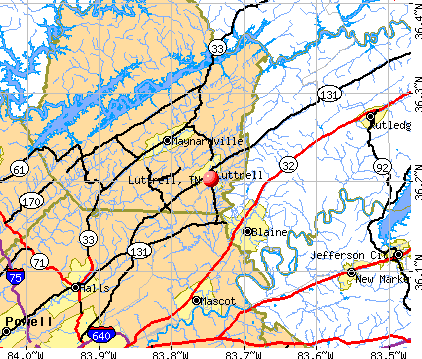
- OSM Map
- General Map
- Google Map
- MSN Map
Population change since 2000: +15.0%
 |
| Males: 540 | |
| Females: 512 |
| Median resident age: | 47.1 years |
| Tennessee median age: | 39.2 years |
Zip codes: 37779.
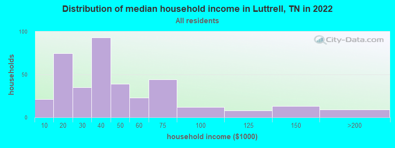
| Luttrell: | $38,002 |
| TN: | $65,254 |
Estimated per capita income in 2022: $18,055 (it was $10,203 in 2000)
Luttrell town income, earnings, and wages data
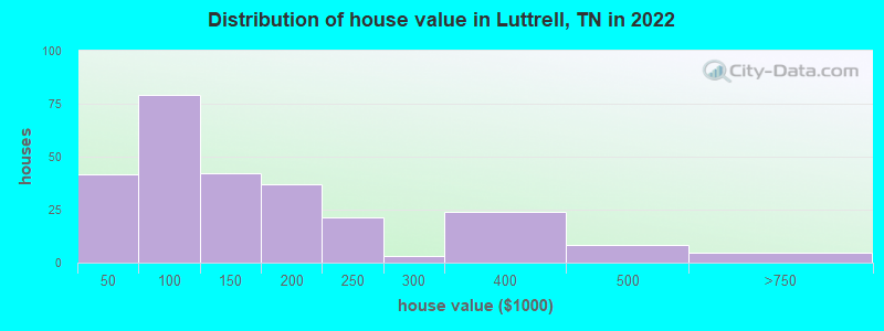
Estimated median house or condo value in 2022: $154,977 (it was $51,400 in 2000)
| Luttrell: | $154,977 |
| TN: | $284,800 |
Mean prices in 2022: all housing units: $154,396; detached houses: $181,253; mobile homes: $95,198
Median gross rent in 2022: $651.
(23.2% for White Non-Hispanic residents, 30.0% for Hispanic or Latino residents, 100.0% for other race residents, 11.5% for two or more races residents)
Detailed information about poverty and poor residents in Luttrell, TN
Compare current foreclosures near Luttrell, TN:
| Photo | Address | Area | Beds / Baths | Price | Details |
|---|---|---|---|---|---|

|
#1
Grace Ave
Luttrell, TN 37779
|
1,568 sq. feet
|
2 baths 3 beds |
$156,000
|
show details |

|
#2
Sallings Rd
Luttrell, TN 37779
|
1,196 sq. feet
|
1 baths - beds |
show details | |

|
#3
Highway 61 E
Luttrell, TN 37779
|
1,280 sq. feet
|
2 baths - beds |
show details | |

|
#4
Highway 61 E
Luttrell, TN 37779
|
2,040 sq. feet
|
1 baths - beds |
show details | |

|
#5
Beeler Ln
Luttrell, TN 37779
|
- sq. feet
|
- baths - beds |
show details | |

|
#6
Texas Hollow Rd
Luttrell, TN 37779
|
1,568 sq. feet
|
- baths - beds |
show details | |

|
#7
Donahue Rd
Luttrell, TN 37779
|
- sq. feet
|
- baths - beds |
show details | |

|
#8
Wolfenbarger Ln # 358
Luttrell, TN 37779
|
1,568 sq. feet
|
- baths - beds |
show details | |

|
#9
Highway 131
Washburn, TN 37888
|
1,400 sq. feet
|
2 baths 3 beds |
$280,000
|
show details |

|
#10
Satterfield Rd
Luttrell, TN 37779
|
- sq. feet
|
- baths - beds |
show details |
| Photo | Address | Area | Beds / Baths | Price | Details |
|---|---|---|---|---|---|

|
#11
Julian Dr
Luttrell, TN 37779
|
- sq. feet
|
- baths - beds |
show details | |

|
#12
Patterson Town Rd
Blaine, TN 37709
|
1,026 sq. feet
|
1 baths - beds |
$24,900
|
show details |

|
#13
Armstrong Rd
Knoxville, TN 37924
|
1,040 sq. feet
|
1 baths 2 beds |
show details | |

|
#14
Cingular Dr
New Tazewell, TN 37825
|
- sq. feet
|
2 baths 3 beds |
show details | |

|
#15
Babelay Rd
Knoxville, TN 37924
|
1,108 sq. feet
|
2 baths 3 beds |
show details | |

|
#16
Rosie Ln
Strawberry Plains, TN 37871
|
4,395 sq. feet
|
3 baths 4 beds |
show details | |

|
#17
San Marcos Dr
Knoxville, TN 37938
|
1,766 sq. feet
|
3 baths 4 beds |
show details | |

|
#18
Foust Hollow Rd
Heiskell, TN 37754
|
1,376 sq. feet
|
1 baths 3 beds |
show details | |

|
#19
Possum Valley Rd
Maynardville, TN 37807
|
1,960 sq. feet
|
3 baths 3 beds |
show details | |

|
#20
Horsestall Dr
Knoxville, TN 37918
|
1,956 sq. feet
|
2 baths 3 beds |
show details |
| Photo | Address | Area | Beds / Baths | Price | Details |
|---|---|---|---|---|---|

|
#21
Jesse Baker Ln
Jefferson City, TN 37760
|
- sq. feet
|
2 baths 4 beds |
show details | |

|
#22
Old Andersonville Pike
Knoxville, TN 37938
|
1,160 sq. feet
|
2 baths 3 beds |
show details | |

|
#23
Willow Falls Way
Knoxville, TN 37917
|
1,026 sq. feet
|
2 baths 2 beds |
show details | |

|
#24
Blackgum Cir
Knoxville, TN 37918
|
1,104 sq. feet
|
2 baths 3 beds |
show details | |

|
#25
Hallsdale Rd
Knoxville, TN 37938
|
1,941 sq. feet
|
2 baths 3 beds |
show details | |

|
#26
Catalpa Ave
Knoxville, TN 37914
|
1,430 sq. feet
|
1 baths 3 beds |
show details | |

|
#27
Lynnview Dr
Knoxville, TN 37918
|
1,367 sq. feet
|
1 baths 2 beds |
show details | |

|
#28
Hillcrest Dr
Knoxville, TN 37918
|
1,430 sq. feet
|
1 baths 3 beds |
show details | |

|
#29
Cedarbreeze Rd
Knoxville, TN 37918
|
1,604 sq. feet
|
1 baths 3 beds |
show details | |

|
#30
Edmondson Ln
Knoxville, TN 37918
|
1,200 sq. feet
|
1 baths 2 beds |
show details |
| Photo | Address | Area | Beds / Baths | Price | Details |
|---|---|---|---|---|---|

|
#31
Fairmont Blvd
Knoxville, TN 37917
|
1,234 sq. feet
|
1 baths 2 beds |
show details | |

|
#32
Periwinkle Rd
Knoxville, TN 37918
|
960 sq. feet
|
2 baths 2 beds |
show details | |

|
#33
Plymouth Rd
Knoxville, TN 37914
|
2,036 sq. feet
|
1 baths 3 beds |
show details | |

|
#34
Wayne Dr
Knoxville, TN 37914
|
1,160 sq. feet
|
1 baths 2 beds |
show details | |

|
#35
Cedar Ln
Knoxville, TN 37918
|
1,450 sq. feet
|
1 baths 3 beds |
show details | |

|
#36
Pitch Pine Dr
Powell, TN 37849
|
1,678 sq. feet
|
2 baths 3 beds |
show details | |

|
#37
Babelay Rd
Knoxville, TN 37924
|
1,075 sq. feet
|
1 baths 3 beds |
show details | |

|
#38
September Ln
Knoxville, TN 37924
|
1,120 sq. feet
|
1 baths 3 beds |
show details | |

|
#39
September Ln
Knoxville, TN 37924
|
1,120 sq. feet
|
1 baths 3 beds |
show details | |

|
#40
Rising Rd
Knoxville, TN 37924
|
1,312 sq. feet
|
1 baths 3 beds |
show details |
| Photo | Address | Area | Beds / Baths | Price | Details |
|---|---|---|---|---|---|

|
#41
Old Dandridge Stage Coach Rd
Knoxville, TN 37914
|
1,536 sq. feet
|
2 baths 2 beds |
show details | |

|
#42
Boright Dr
Knoxville, TN 37917
|
720 sq. feet
|
1 baths 2 beds |
show details | |

|
#43
Wilmouth Run Rd
Knoxville, TN 37918
|
1,180 sq. feet
|
2 baths 2 beds |
show details | |

|
#44
Tecoma Dr
Knoxville, TN 37917
|
1,380 sq. feet
|
2 baths 4 beds |
show details | |

|
#45
Guinn Dr
New Market, TN 37820
|
2,280 sq. feet
|
2 baths 3 beds |
show details | |

|
#46
Hillcrest Dr
Knoxville, TN 37918
|
1,393 sq. feet
|
1 baths 3 beds |
show details | |

|
#47
Midview Ln
Knoxville, TN 37938
|
1,852 sq. feet
|
2 baths 3 beds |
show details | |

|
#48
Lupine Dr
Knoxville, TN 37924
|
2,655 sq. feet
|
2 baths 4 beds |
show details | |

|
#49
Drinnen Rd
Knoxville, TN 37914
|
1,512 sq. feet
|
1 baths 3 beds |
show details | |

|
Check over 1 million property listings on Foreclosure.com!
|
browse all offers | |||


- 89696.0%White alone
- 212.3%Hispanic
- 101.1%Two or more races
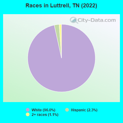
Races in Luttrell detailed stats: ancestries, foreign born residents, place of birth
According to our research of Tennessee and other state lists, there were 14 registered sex offenders living in Luttrell, Tennessee as of May 17, 2024.
The ratio of all residents to sex offenders in Luttrell is 65 to 1.
 Recent articles from our blog. Our writers, many of them Ph.D. graduates or candidates, create easy-to-read articles on a wide variety of topics.

 | Luttrell questions (1 reply) |
| Neighborhood recommendations in Knoxville (6 replies) |
| Tennessee Ranked 4th worse place to live (28 replies) |
| Memphis Decline (89 replies) |
| Wanting to move to Luttrell TN (20 replies) |
| Elon (1 reply) |
Latest news from Luttrell, TN collected exclusively by city-data.com from local newspapers, TV, and radio stations
Ancestries: American (35.0%), Norwegian (27.0%), German (5.2%), Irish (5.0%), English (4.0%), Italian (1.9%).
Current Local Time: EST time zone
Incorporated in 1925
Land area: 3.93 square miles.
Population density: 268 people per square mile (very low).
5 residents are foreign born
| This town: | 0.5% |
| Tennessee: | 5.4% |
Median real estate property taxes paid for housing units with mortgages in 2022: $500 (0.3%)
Median real estate property taxes paid for housing units with no mortgage in 2022: $523 (0.3%)
Nearest city with pop. 50,000+: Knoxville, TN  (19.3 miles , pop. 173,890).
Nearest city with pop. 200,000+: Fayette, KY (132.9 miles , pop. 260,512).
Nearest city with pop. 1,000,000+: Chicago, IL (443.4 miles , pop. 2,896,016).
Nearest cities:
), ), ), ), ), )Latitude: 36.20 N, Longitude: 83.75 W
Area code commonly used in this area: 865
| Here: | 3.3% |
| Tennessee: | 3.0% |
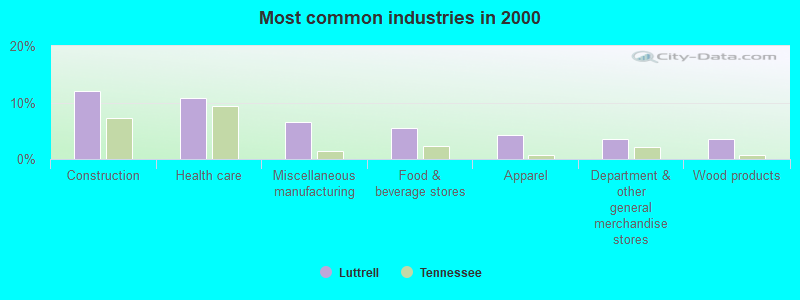
- Construction (12.0%)
- Health care (10.7%)
- Miscellaneous manufacturing (6.5%)
- Food & beverage stores (5.5%)
- Apparel (4.2%)
- Department & other general merchandise stores (3.6%)
- Wood products (3.6%)
- Construction (19.5%)
- Food & beverage stores (10.1%)
- Miscellaneous manufacturing (7.5%)
- Wood products (6.9%)
- Utilities (6.3%)
- Repair & maintenance (5.7%)
- Truck transportation (5.7%)
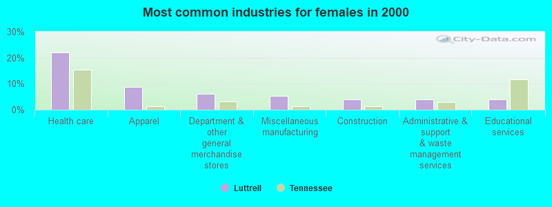
- Health care (22.1%)
- Apparel (8.7%)
- Department & other general merchandise stores (6.0%)
- Miscellaneous manufacturing (5.4%)
- Construction (4.0%)
- Administrative & support & waste management services (4.0%)
- Educational services (4.0%)

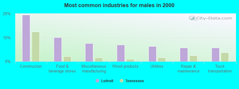
- Driver/sales workers and truck drivers (7.8%)
- Material recording, scheduling, dispatching, and distributing workers (6.8%)
- Building and grounds cleaning and maintenance occupations (6.2%)
- Construction traders workers except carpenters, electricians, painters, plumbers, and construction laborers (6.2%)
- Retail sales workers, except cashiers (4.5%)
- Secretaries and administrative assistants (4.5%)
- Textile, apparel, and furnishings workers (4.2%)
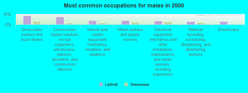
- Driver/sales workers and truck drivers (13.8%)
- Construction traders workers except carpenters, electricians, painters, plumbers, and construction laborers (11.9%)
- Vehicle and mobile equipment mechanics, installers, and repairers (6.3%)
- Metal workers and plastic workers (6.3%)
- Electrical equipment mechanics and other installation, maintenance, and repair workers, including supervisors (5.7%)
- Material recording, scheduling, dispatching, and distributing workers (5.0%)
- Electricians (5.0%)
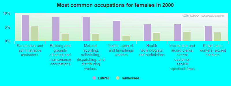
- Secretaries and administrative assistants (9.4%)
- Building and grounds cleaning and maintenance occupations (8.7%)
- Material recording, scheduling, dispatching, and distributing workers (8.7%)
- Textile, apparel, and furnishings workers (7.4%)
- Health technologists and technicians (6.0%)
- Information and record clerks, except customer service representatives (6.0%)
- Retail sales workers, except cashiers (5.4%)
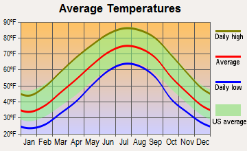
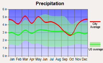
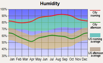
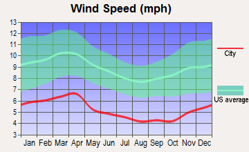
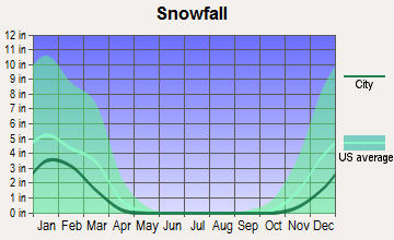
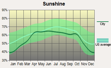
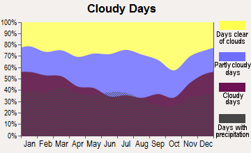
Average climate in Luttrell, Tennessee
Based on data reported by over 4,000 weather stations
(lower is better)
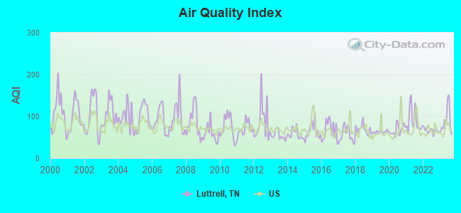
Air Quality Index (AQI) level in 2023 was 89.5. This is worse than average.
| City: | 89.5 |
| U.S.: | 72.6 |
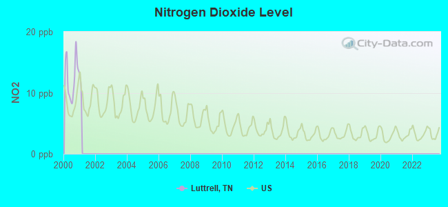
Nitrogen Dioxide (NO2) [ppb] level in 2000 was 12.6. This is significantly worse than average. Closest monitor was 7.0 miles away from the city center.
| City: | 12.6 |
| U.S.: | 5.1 |
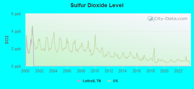
Sulfur Dioxide (SO2) [ppb] level in 2000 was 2.45. This is significantly worse than average. Closest monitor was 7.0 miles away from the city center.
| City: | 2.45 |
| U.S.: | 1.51 |
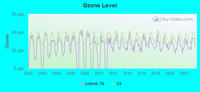
Ozone [ppb] level in 2023 was 29.3. This is about average. Closest monitor was 7.0 miles away from the city center.
| City: | 29.3 |
| U.S.: | 33.3 |
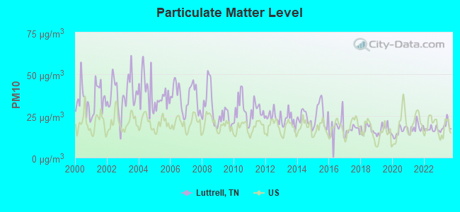
Particulate Matter (PM10) [µg/m3] level in 2023 was 18.9. This is about average. Closest monitor was 2.3 miles away from the city center.
| City: | 18.9 |
| U.S.: | 19.2 |
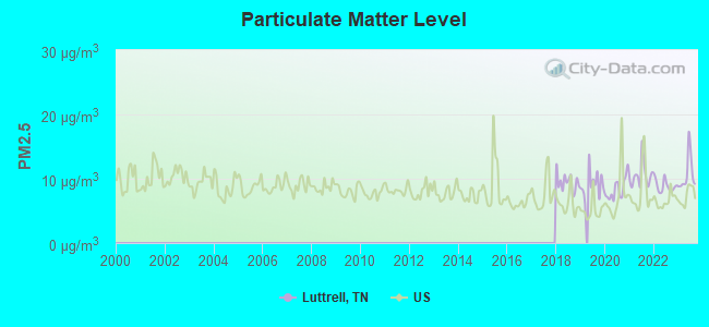
Particulate Matter (PM2.5) [µg/m3] level in 2023 was 10.7. This is worse than average. Closest monitor was 14.6 miles away from the city center.
| City: | 10.7 |
| U.S.: | 8.1 |
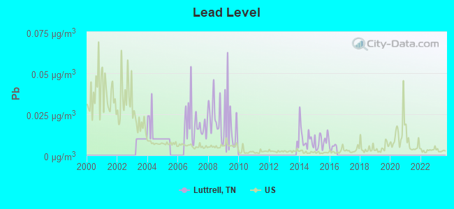
Lead (Pb) [µg/m3] level in 2015 was 0.00868. This is about average. Closest monitor was 14.9 miles away from the city center.
| City: | 0.00868 |
| U.S.: | 0.00931 |
Tornado activity:
Luttrell-area historical tornado activity is significantly below Tennessee state average. It is 43% smaller than the overall U.S. average.
On 2/21/1993, a category F3 (max. wind speeds 158-206 mph) tornado 14.4 miles away from the Luttrell town center injured 3 people and caused between $500,000 and $5,000,000 in damages.
On 5/9/1988, a category F3 tornado 27.5 miles away from the town center killed one person and injured 15 people and caused between $5,000,000 and $50,000,000 in damages.
Earthquake activity:
Luttrell-area historical earthquake activity is significantly above Tennessee state average. It is 70% greater than the overall U.S. average.On 11/30/1973 at 07:48:41, a magnitude 4.7 (4.7 MB, 4.6 ML, Class: Light, Intensity: IV - V) earthquake occurred 30.5 miles away from Luttrell center
On 7/27/1980 at 18:52:21, a magnitude 5.2 (5.1 MB, 4.7 MS, 5.0 UK, 5.2 UK, Class: Moderate, Intensity: VI - VII) earthquake occurred 138.9 miles away from the city center
On 8/9/2020 at 12:07:37, a magnitude 5.1 (5.1 MW, Depth: 4.7 mi) earthquake occurred 149.0 miles away from the city center
On 4/29/2003 at 08:59:39, a magnitude 4.9 (4.4 MB, 4.6 MW, 4.9 LG) earthquake occurred 158.9 miles away from the city center
On 8/23/2011 at 17:51:04, a magnitude 5.8 (5.8 MW, Depth: 3.7 mi) earthquake occurred 341.6 miles away from Luttrell center
On 12/12/2018 at 09:14:43, a magnitude 4.4 (4.4 MW, Depth: 4.9 mi) earthquake occurred 68.7 miles away from Luttrell center
Magnitude types: regional Lg-wave magnitude (LG), body-wave magnitude (MB), local magnitude (ML), surface-wave magnitude (MS), moment magnitude (MW)
Natural disasters:
The number of natural disasters in Union County (11) is smaller than the US average (15).Major Disasters (Presidential) Declared: 7
Emergencies Declared: 2
Causes of natural disasters: Floods: 6, Storms: 5, Winter Storms: 3, Tornadoes: 2, Flash Flood: 1, Heavy Rain: 1, Hurricane: 1, Ice Storm: 1, Landslide: 1, Mudslide: 1, Snowfall: 1, Other: 1 (Note: some incidents may be assigned to more than one category).
Hospitals and medical centers near Luttrell:
- WARIOTA HLTH CARE CTR (Nursing Home, about 5 miles away; MAYNARDVILLE, TN)
- WILLOW RIDGE CARE AND REHABILITATION CENTER (Nursing Home, about 5 miles away; MAYNARDVILLE, TN)
- ST MARY'S HOSPICE (Hospital, about 14 miles away; KNOXVILLE, TN)
- LIFE CARE CTR OF JEFFERSON CITY (Nursing Home, about 14 miles away; JEFFERSON CITY, TN)
- MERCY HOMECARE SERVICES (Home Health Center, about 14 miles away; KNOXVILLE, TN)
- LIFE CARE CENTER OF JEFFERSON CITY (Nursing Home, about 15 miles away; JEFFERSON CITY, TN)
- JEFFERSON CITY HEALTH AND REHAB CENTER (Nursing Home, about 15 miles away; JEFFERSON CITY, TN)
Colleges/universities with over 2000 students nearest to Luttrell:
- The University of Tennessee-Knoxville (about 20 miles; Knoxville, TN; Full-time enrollment: 25,483)
- Lincoln Memorial University (about 27 miles; Harrogate, TN; FT enrollment: 3,706)
- Walters State Community College (about 28 miles; Morristown, TN; FT enrollment: 4,359)
- Pellissippi State Community College (about 30 miles; Knoxville, TN; FT enrollment: 7,271)
- University of the Cumberlands (about 44 miles; Williamsburg, KY; FT enrollment: 3,585)
- Roane State Community College (about 54 miles; Harriman, TN; FT enrollment: 4,302)
- Tusculum College (about 55 miles; Greeneville, TN; FT enrollment: 2,070)
Public elementary/middle school in Luttrell:
- LUTTRELL ELEMENTARY (Students: 360, Location: 241 TAZEWELL PK, Grades: PK-5)
User-submitted facts and corrections:
- Kenny Chesney grew up in Luttrell, he is currently the highest grossing recording artist in the world.
Points of interest:
Notable location: Luttrell Volunteer Fire Department (A). Display/hide its location on the map
Churches in Luttrell include: Cedar Ford Church (A), Holiness Church (B). Display/hide their locations on the map
Cemeteries: Hubbs Cemetery (1), Archer Cemetery (2). Display/hide their locations on the map
Creek: Little Creek (A). Display/hide its location on the map
Birthplace of: Chet Atkins - (1924-2001), composer, musician.
Drinking water stations with addresses in Luttrell that have no violations reported:
- LUTTRELL-BLAINE-CORRYTON U.D. (Population served: 8,879, Primary Water Source Type: Surface water)
| This town: | 2.5 people |
| Tennessee: | 2.5 people |
| This town: | 69.3% |
| Whole state: | 67.3% |
| This town: | 5.0% |
| Whole state: | 5.8% |
No gay or lesbian households reported
8 people in other noninstitutional group quarters in 2000
Banks with branches in Luttrell (2011 data):
- Commercial Bank: Luttrell Branch at 111 Tazewell Pike, branch established on 1972/11/22. Info updated 2008/09/25: Bank assets: $807.9 mil, Deposits: $626.4 mil, headquarters in Harrogate, TN, positive income, Commercial Lending Specialization, 20 total offices, Holding Company: Unified Shares, Llc
For population 15 years and over in Luttrell:
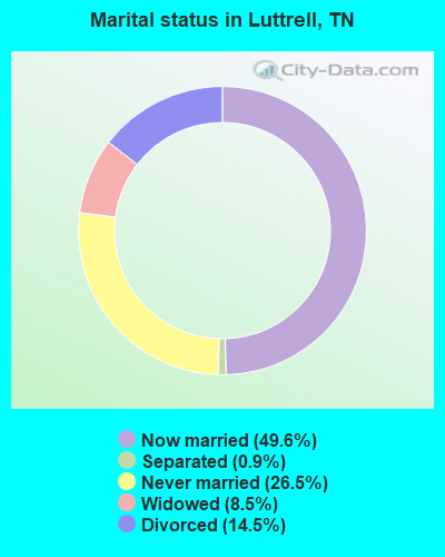
- Never married: 26.5%
- Now married: 49.6%
- Separated: 0.9%
- Widowed: 8.5%
- Divorced: 14.5%
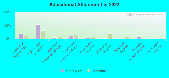
For population 25 years and over in Luttrell:
- High school or higher: 75.8%
- Bachelor's degree or higher: 7.9%
- Graduate or professional degree: 6.7%
- Unemployed: 8.9%
- Mean travel time to work (commute): 38.8 minutes
| Here: | 11.3 |
| Tennessee average: | 11.4 |
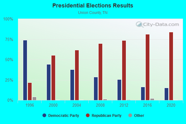
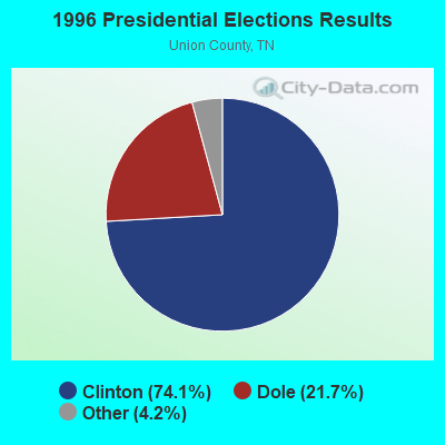
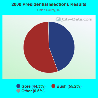
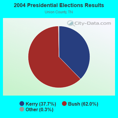
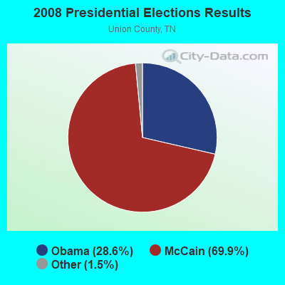
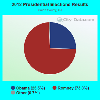
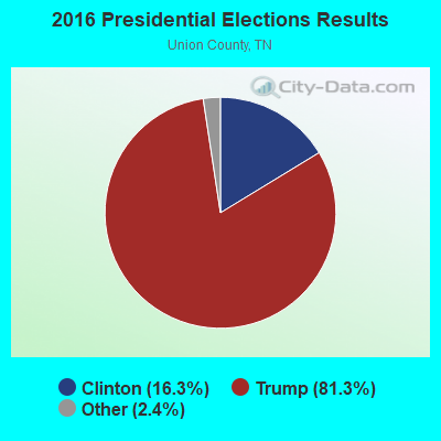
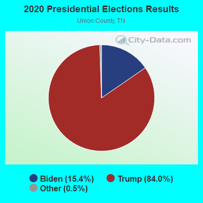
Graphs represent county-level data. Detailed 2008 Election Results
Religion statistics for Luttrell, TN (based on Union County data)
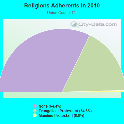
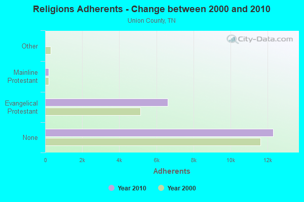
| Religion | Adherents | Congregations |
|---|---|---|
| Evangelical Protestant | 6,616 | 24 |
| Mainline Protestant | 181 | 3 |
| Other | 3 | - |
| None | 12,309 | - |
Food Environment Statistics:
| Union County: | 1.06 / 10,000 pop. |
| State: | 1.99 / 10,000 pop. |
| This county: | 0.53 / 10,000 pop. |
| Tennessee: | 0.65 / 10,000 pop. |
| This county: | 4.78 / 10,000 pop. |
| State: | 5.16 / 10,000 pop. |
| Union County: | 2.65 / 10,000 pop. |
| Tennessee: | 6.56 / 10,000 pop. |
| Union County: | 10.5% |
| Tennessee: | 11.4% |
| This county: | 27.5% |
| Tennessee: | 30.2% |
| This county: | 12.6% |
| Tennessee: | 13.5% |
Health and Nutrition:
| Luttrell: | 62.6% |
| Tennessee: | 49.3% |
| Luttrell: | 65.7% |
| State: | 46.1% |
| Luttrell: | 27.4 |
| State: | 28.8 |
| Here: | 13.2% |
| State: | 21.0% |
| This city: | 6.9 |
| Tennessee: | 6.8 |
| Here: | 30.0% |
| State: | 33.9% |
| Luttrell: | 69.6% |
| Tennessee: | 55.9% |
| Luttrell: | 82.5% |
| Tennessee: | 79.1% |
More about Health and Nutrition of Luttrell, TN Residents
| Local government employment and payroll (March 2022) | |||||
| Function | Full-time employees | Monthly full-time payroll | Average yearly full-time wage | Part-time employees | Monthly part-time payroll |
|---|---|---|---|---|---|
| Sewerage | 2 | $8,065 | $48,390 | 4 | $5,532 |
| Financial Administration | 1 | $2,610 | $31,320 | 0 | $0 |
| Other Government Administration | 0 | $0 | 1 | $300 | |
| Totals for Government | 3 | $10,675 | $42,700 | 5 | $5,832 |
Luttrell government finances - Expenditure in 2017 (per resident):
- Current Operations - Sewerage: $396,000 ($376.43)
Regular Highways: $65,000 ($61.79)
Parks and Recreation: $32,000 ($30.42)
Financial Administration: $21,000 ($19.96)
General - Other: $19,000 ($18.06)
Central Staff Services: $17,000 ($16.16)
Libraries: $16,000 ($15.21)
General Public Buildings: $9,000 ($8.56)
- General - Interest on Debt: $26,000 ($24.71)
- Other Capital Outlay - Sewerage: $393,000 ($373.57)
Regular Highways: $44,000 ($41.83)
Central Staff Services: $3,000 ($2.85)
- Total Salaries and Wages: $152,000 ($144.49)
Luttrell government finances - Revenue in 2017 (per resident):
- Charges - Sewerage: $393,000 ($373.57)
- Local Intergovernmental - General Local Government Support: $23,000 ($21.86)
- Miscellaneous - Donations From Private Sources: $21,000 ($19.96)
Rents: $1,000 ($0.95)
Interest Earnings: $1,000 ($0.95)
- State Intergovernmental - Sewerage: $284,000 ($269.96)
General Local Government Support: $91,000 ($86.50)
Highways: $29,000 ($27.57)
Other: $6,000 ($5.70)
- Tax - Alcoholic Beverage Sales: $33,000 ($31.37)
Public Utilities Sales: $13,000 ($12.36)
Luttrell government finances - Debt in 2017 (per resident):
- Long Term Debt - Beginning Outstanding - Unspecified Public Purpose: $454,000 ($431.56)
Outstanding Unspecified Public Purpose: $397,000 ($377.38)
Retired Unspecified Public Purpose: $57,000 ($54.18)
Luttrell government finances - Cash and Securities in 2017 (per resident):
- Other Funds - Cash and Securities: $227,000 ($215.78)
Strongest AM radio stations in Luttrell:
- WKVL (850 AM; daytime; 50 kW; KNOXVILLE, TN; Owner: HORNE RADIO, LLC)
- WNOX (990 AM; 10 kW; KNOXVILLE, TN)
- WVLZ (1180 AM; daytime; 10 kW; KNOXVILLE, TN; Owner: KIRKLAND WIRELESS BROADCASTERS, INC.)
- WRJZ (620 AM; 5 kW; KNOXVILLE, TN; Owner: TENNESSEE MEDIA ASSOCIATES, INC)
- WQBB (1040 AM; daytime; 10 kW; POWELL, TN; Owner: JOURNAL BROADCAST CORPORATION)
- WMEN (760 AM; daytime; 2 kW; KNOXVILLE, TN; Owner: THOMAS MOFFIT JR.)
- WSEV (930 AM; 5 kW; SEVIERVILLE, TN; Owner: EAST TENNESSEE RADIO GROUP, L.P.)
- WMTN (1300 AM; 5 kW; MORRISTOWN, TN)
- WCRK (1150 AM; 5 kW; MORRISTOWN, TN; Owner: RADIO ACQUISITION CORP.)
- WFGW (1010 AM; 50 kW; BLACK MOUNTAIN, NC; Owner: BLUE RIDGE BROADCASTING CORP.)
- WLFJ (660 AM; daytime; 50 kW; GREENVILLE, SC; Owner: CLEAR CHANNEL BROADCASTING LICENSES, INC.)
- WATO (1290 AM; 5 kW; OAK RIDGE, TN)
- WMIK (560 AM; 2 kW; MIDDLESBORO, KY; Owner: GATEWAY BROADCASTING, INC.)
Strongest FM radio stations in Luttrell:
- WIMZ-FM (103.5 FM; KNOXVILLE, TN; Owner: SOUTH CENTRAL COMM., CORP.)
- WUOT (91.9 FM; KNOXVILLE, TN; Owner: UNIVERSITY OF TENNESSEE)
- WOKI-FM (100.3 FM; OAK RIDGE, TN; Owner: OAK RIDGE FM, INC.)
- WJXB-FM (97.5 FM; KNOXVILLE, TN; Owner: SOUTH CENTRAL COMMUNICATIONS CORP.)
- WRMX-FM (106.7 FM; NORRIS, TN; Owner: SOUTH CENTRAL COMMUNICATIONS CORPORATION)
- WIVK-FM (107.7 FM; KNOXVILLE, TN; Owner: CITADEL BROADCASTING COMPANY)
- WDVX (89.9 FM; CLINTON, TN; Owner: CUMBERLAND COMMUNITIES COMMUNI CORP.)
- WWST (102.1 FM; SEVIERVILLE, TN; Owner: JOURNAL BROADCAST CORPORATION)
- WEZG (99.3 FM; JEFFERSON CITY, TN; Owner: EAST TENNESSEE RADIO GROUP, L.P.)
- WYLV (89.1 FM; ALCOA, TN; Owner: FOOTHILLS BROADCASTING, INC.)
- WCTU (105.9 FM; TAZEWELL, TN; Owner: STAIR COMPANY, INC)
- WMIK-FM (92.7 FM; MIDDLESBORO, KY; Owner: GATEWAY BROADCASTING, INC.)
- WYFC (95.3 FM; CLINTON, TN; Owner: BIBLE BROADCASTING NETWORK, INC.)
- WMXK (94.1 FM; MORRISTOWN, TN; Owner: HORNE RADIO, LLC)
- WKHT (104.5 FM; KNOXVILLE, TN; Owner: JOURNAL BROADCAST CORPORATION)
- WBGQ (100.7 FM; BULLS GAP, TN; Owner: CHEROKEE BROADCASTING)
- WJDT (106.5 FM; ROGERSVILLE, TN; Owner: C & S BROADCASTING)
- WYIL-FM (98.7 FM; OLIVER SPRINGS, TN; Owner: CITADEL BROADCASTING COMPANY)
- WJBZ-FM (96.3 FM; SEYMOUR, TN; Owner: SEYMOUR COMMUNICATIONS)
- W237AR (95.3 FM; HAZELWOOD, ETC., NC; Owner: WESTERN NORTH CAROLINA PUBLIC RADIO)
TV broadcast stations around Luttrell:
- WKOP-TV (Channel 15; KNOXVILLE, TN; Owner: EAST TENNESSEE PUBLIC COMMUNICATIONS CORP.)
- WBIR-TV (Channel 10; KNOXVILLE, TN; Owner: GANNETT PACIFIC CORPORATION)
- WATE-TV (Channel 6; KNOXVILLE, TN; Owner: WATE, G.P.)
- WVLT-TV (Channel 8; KNOXVILLE, TN; Owner: WVLT LICENSEE CORP.)
- WTNZ (Channel 43; KNOXVILLE, TN; Owner: RAYCOM AMERICA, INC.)
- WEZK-LP (Channel 28; KNOXVILLE, TN; Owner: SOUTH CENTRAL COMMUNICATIONS CORP.)
- WEEE-LP (Channel 32; KNOXVILLE, TN; Owner: TIGER EYE BROADCASTING CORPORATION)
- WVLR (Channel 48; TAZEWELL, TN; Owner: VOLUNTEER CHRISTIAN TELEVISION, INC.)
- WDTT-LP (Channel 38; LENOIR CITY, TN; Owner: WORD OF GOD FELLOWSHIP, INC.)
- W50CG (Channel 50; KNOXVILLE, TN; Owner: THREE ANGELS BROADCASTING NETWORK, INC.)
- W46DC (Channel 46; KNOXVILLE, TN; Owner: TRINITY BROADCASTING NETWORK)
- W56CM (Channel 56; KNOXVILLE, TN; Owner: VENTANA TELEVISION, INC.)
- WFEM-LP (Channel 12; HEISKELL, ETC., TN; Owner: H. EARL MARLAR)
- WJZC-LP (Channel 22; SEVIERVILLE, TN; Owner: SOUTH CENTRAL COMMUNICATIONS CORP.)
- Luttrell, Tennessee
- Fatal accident count12
- Vehicles involved in fatal accidents16
- Fatal accidents involving drunk persons:5
- Fatalities13
- Persons involved in fatal accidents21
- Pedestrians involved in fatal accidents3
- Tennessee average
- Fatal accident count11315
- Vehicles involved in fatal accidents16854
- Fatal accidents involving drunk persons4266
- Fatalities12559
- Persons involved in fatal accidents27568
- Pedestrians involved in fatal accidents617
- National Bridge Inventory (NBI) Statistics
- 18Number of bridges
- 82ft / 24.6mTotal length
- $1,445,000Total costs
- 11,044Total average daily traffic
- 439Total average daily truck traffic
- 16,960Total future (year 2038) average daily traffic
- New bridges - historical statistics
- 11940-1949
- 11950-1959
- 11960-1969
- 41970-1979
- 81980-1989
- 11990-1999
- 22010-2019
FCC Registered Antenna Towers:
22 (See the full list of FCC Registered Antenna Towers in Luttrell)FCC Registered Broadcast Land Mobile Towers:
2- Scenic View Tank, Tank On Ridgecrest Rd. (Lat: 36.228583 Lon: -83.745833), Type: Tank, Structure height: 9.7 m, Overall height: 13.7 m, Call Sign: WQCP589,
Assigned Frequencies: 460.662 MHz, Grant Date: 02/05/2015, Expiration Date: 04/25/2025, Certifier: Jimmy Langley, Registrant: Dexter Fortson Associates, Inc., 5511 Powder Plant Ln, Bessemer, AL 35022, Phone: (205) 432-2700, Fax: (205) 491-4751, Email:
- CLINCH VALLEY RD, Lat: 36.225639 Lon: -83.716417, Call Sign: WQXL559,
Assigned Frequencies: 451.475 MHz, 456.787 MHz, 457.212 MHz, 464.362 MHz, 464.462 MHz, 464.662 MHz, 469.100 MHz, 464.050 MHz, Grant Date: 04/07/2016, Expiration Date: 04/07/2026, Certifier: Peter Baudendistel, Registrant: Tunnel Radio Of America, 6435 Ne Hyslop Road, Corvallis, OR 97330, Phone: (541) 758-5637, Fax: (541) 758-1417, Email:
FCC Registered Amateur Radio Licenses:
36 (See the full list of FCC Registered Amateur Radio Licenses in Luttrell)FAA Registered Aircraft:
9 (See the full list of FAA Registered Aircraft in Luttrell)2002 - 2018 National Fire Incident Reporting System (NFIRS) incidents
- Fire incident types reported to NFIRS in Luttrell, TN
- 24959.4%Structure Fires
- 12529.8%Outside Fires
- 245.7%Other
- 215.0%Mobile Property/Vehicle Fires
 Based on the data from the years 2002 - 2018 the average number of fire incidents per year is 25. The highest number of reported fire incidents - 51 took place in 2009, and the least - 2 in 2003. The data has a rising trend.
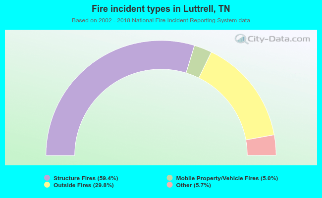 When looking into fire subcategories, the most reports belonged to: Structure Fires (59.4%), and Outside Fires (29.8%).
| Most common first names in Luttrell, TN among deceased individuals | ||
| Name | Count | Lived (average) |
|---|---|---|
| James | 31 | 66.8 years |
| Mary | 23 | 77.9 years |
| William | 22 | 73.3 years |
| John | 15 | 73.5 years |
| Robert | 12 | 68.5 years |
| Charles | 10 | 75.6 years |
| Earl | 9 | 71.8 years |
| Horace | 9 | 77.2 years |
| Clarence | 9 | 78.1 years |
| Fred | 8 | 75.4 years |
| Most common last names in Luttrell, TN among deceased individuals | ||
| Last name | Count | Lived (average) |
|---|---|---|
| Kitts | 24 | 75.9 years |
| Dyer | 23 | 75.5 years |
| Booker | 21 | 80.1 years |
| Beeler | 20 | 72.2 years |
| Wolfenbarger | 19 | 71.6 years |
| Tharp | 17 | 72.9 years |
| Wyrick | 16 | 69.3 years |
| Atkins | 16 | 74.4 years |
| Williams | 16 | 74.4 years |
| Devault | 14 | 80.0 years |
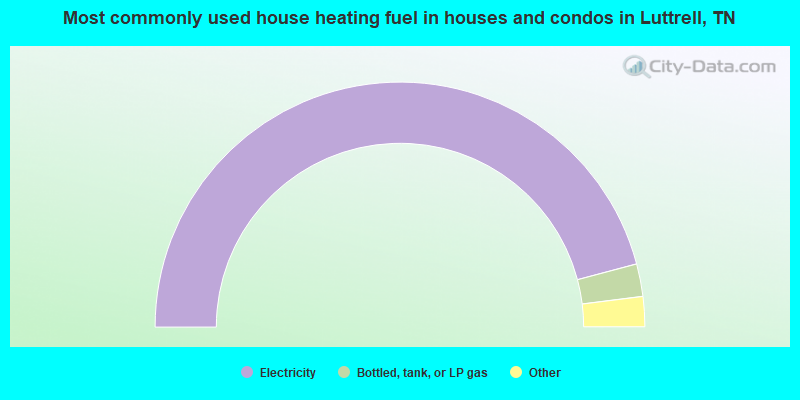
- 92.0%Electricity
- 4.3%Bottled, tank, or LP gas
- 2.0%Fuel oil, kerosene, etc.
- 1.0%No fuel used
- 0.7%Wood
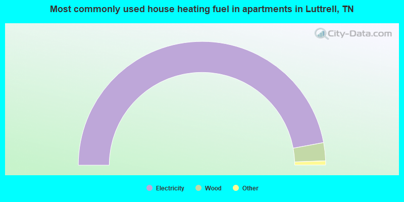
- 95.2%Electricity
- 4.8%Wood
Luttrell compared to Tennessee state average:
- Median household income below state average.
- Median house value below state average.
- Black race population percentage significantly below state average.
- Hispanic race population percentage below state average.
- Median age below state average.
- Foreign-born population percentage significantly below state average.
- Length of stay since moving in significantly above state average.
- Number of college students significantly below state average.
- Percentage of population with a bachelor's degree or higher significantly below state average.

|
Total of 1 patent application in 2008-2024.