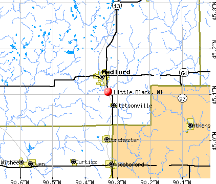
Little Black, Wisconsin
Submit your own pictures of this town and show them to the world
- OSM Map
- General Map
- Google Map
- MSN Map
Population change since 2000: -0.7%
 |
| Males: 592 | |
| Females: 548 |
| Median resident age: | 42.1 years |
| Wisconsin median age: | 42.6 years |
Zip codes: 54451.
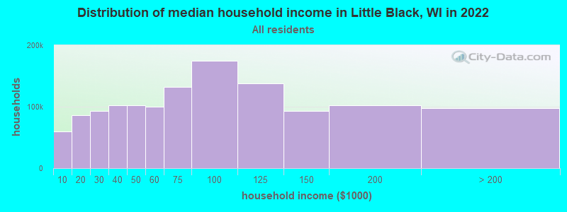
| Little Black: | $70,269 |
| WI: | $70,996 |
Estimated per capita income in 2022: $33,040 (it was $17,633 in 2000)
Little Black town income, earnings, and wages data
Estimated median house or condo value in 2022: $200,090 (it was $85,500 in 2000)
| Little Black: | $200,090 |
| WI: | $252,800 |
Mean prices in 2022: all housing units: $225,755; detached houses: $237,087; townhouses or other attached units: $201,679; in 2-unit structures: $217,833; in 3-to-4-unit structures: $267,787; mobile homes: $86,490
Detailed information about poverty and poor residents in Little Black, WI
Compare current foreclosures near Little Black, WI:
| Photo | Address | Area | Beds / Baths | Price | Details |
|---|---|---|---|---|---|

|
#1
Elm Ave
Dorchester, WI 54425
|
- sq. feet
|
2 baths 3 beds |
show details | |

|
#2
Elm Ave
Dorchester, WI 54425
|
- sq. feet
|
- baths - beds |
show details | |

|
#3
Della Ln
Medford, WI 54451
|
- sq. feet
|
- baths - beds |
show details | |

|
#4
N Park Ave
Medford, WI 54451
|
- sq. feet
|
- baths - beds |
show details | |

|
#5
Riverside Ter
Medford, WI 54451
|
- sq. feet
|
- baths - beds |
show details | |

|
#6
Riverside Ter
Medford, WI 54451
|
- sq. feet
|
- baths - beds |
show details | |

|
#7
Hickory Rd
Curtiss, WI 54422
|
- sq. feet
|
- baths - beds |
show details | |

|
#8
County Rd E
Curtiss, WI 54422
|
- sq. feet
|
- baths - beds |
show details | |

|
#9
Dehne Dr
Colby, WI 54421
|
- sq. feet
|
- baths - beds |
show details | |

|
#10
S Main St
Colby, WI 54421
|
- sq. feet
|
- baths - beds |
show details |
| Photo | Address | Area | Beds / Baths | Price | Details |
|---|---|---|---|---|---|

|
#11
E 9th St
Owen, WI 54460
|
- sq. feet
|
- baths - beds |
show details | |

|
#12
S 8th St
Medford, WI 54451
|
- sq. feet
|
- baths - beds |
show details | |

|
#13
N 7th St
Colby, WI 54421
|
- sq. feet
|
- baths - beds |
show details | |

|
Check over 1 million property listings on Foreclosure.com!
|
browse all offers | |||

- 1,10697.0%White alone
- 262.3%Hispanic
- 30.3%Asian alone
- 20.2%American Indian alone
- 20.2%Two or more races
- 10.09%Black alone
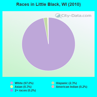
Races in Little Black detailed stats: ancestries, foreign born residents, place of birth
 Recent articles from our blog. Our writers, many of them Ph.D. graduates or candidates, create easy-to-read articles on a wide variety of topics.

 | Verona/Madison - Things to do (2 replies) |
Latest news from Little Black, WI collected exclusively by city-data.com from local newspapers, TV, and radio stations
Ancestries: German (63.9%), Polish (6.5%), Norwegian (6.1%), Irish (5.4%), United States (5.1%), English (4.8%).
Current Local Time: CST time zone
Elevation: 1418 feet
Land area: 35.0 square miles.
Population density: 33 people per square mile (very low).
2 residents are foreign born
| This town: | 0.2% |
| Wisconsin: | 3.6% |
| Little Black town: | 1.6% ($1,390) |
| Wisconsin: | 2.0% ($2,245) |
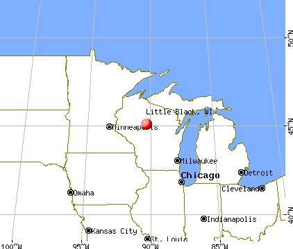
Nearest city with pop. 50,000+: Eau Claire, WI  (58.2 miles , pop. 61,704).
Nearest city with pop. 200,000+: St. Paul, MN (134.7 miles , pop. 287,151).
Nearest city with pop. 1,000,000+: Chicago, IL (261.7 miles , pop. 2,896,016).
Nearest cities:
), ), ), ), ), )Latitude: 45.08 N, Longitude: 90.37 W
Area code commonly used in this area: 715

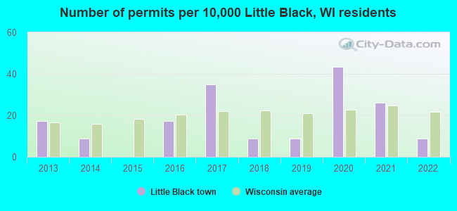
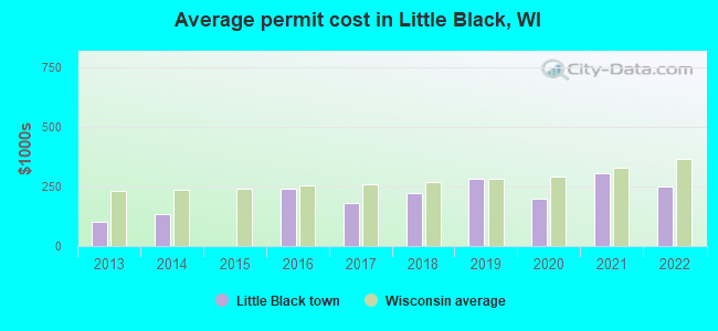
Single-family new house construction building permits:
- 2022: 1 building, cost: $250,000
- 2021: 3 buildings, average cost: $306,700
- 2020: 5 buildings, average cost: $199,400
- 2019: 1 building, cost: $283,500
- 2018: 1 building, cost: $222,800
- 2017: 4 buildings, average cost: $182,500
- 2016: 2 buildings, average cost: $242,500
- 2014: 1 building, cost: $134,000
- 2013: 2 buildings, average cost: $103,800
| Here: | 4.1% |
| Wisconsin: | 2.7% |
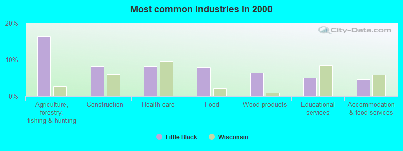
- Agriculture, forestry, fishing & hunting (16.4%)
- Construction (8.1%)
- Health care (8.1%)
- Food (7.8%)
- Wood products (6.4%)
- Educational services (5.2%)
- Accommodation & food services (4.7%)
- Agriculture, forestry, fishing & hunting (21.1%)
- Construction (11.9%)
- Food (11.4%)
- Wood products (6.9%)
- Truck transportation (6.7%)
- Educational services (4.4%)
- Accommodation & food services (4.2%)
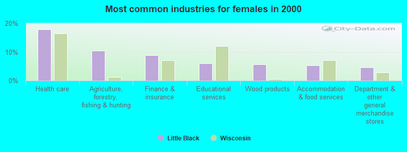
- Health care (17.9%)
- Agriculture, forestry, fishing & hunting (10.4%)
- Finance & insurance (8.9%)
- Educational services (6.1%)
- Wood products (5.7%)
- Accommodation & food services (5.4%)
- Department & other general merchandise stores (4.6%)
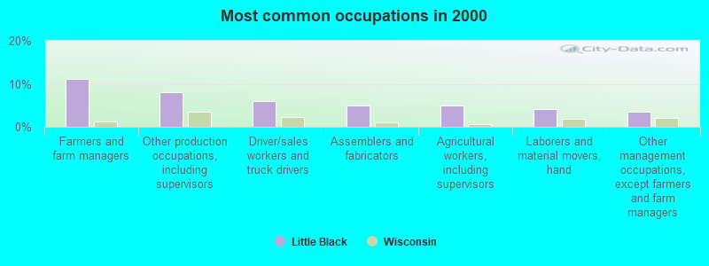
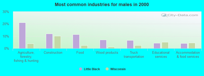
- Farmers and farm managers (11.1%)
- Other production occupations, including supervisors (8.0%)
- Driver/sales workers and truck drivers (5.9%)
- Assemblers and fabricators (5.0%)
- Agricultural workers, including supervisors (5.0%)
- Laborers and material movers, hand (4.1%)
- Other management occupations, except farmers and farm managers (3.4%)
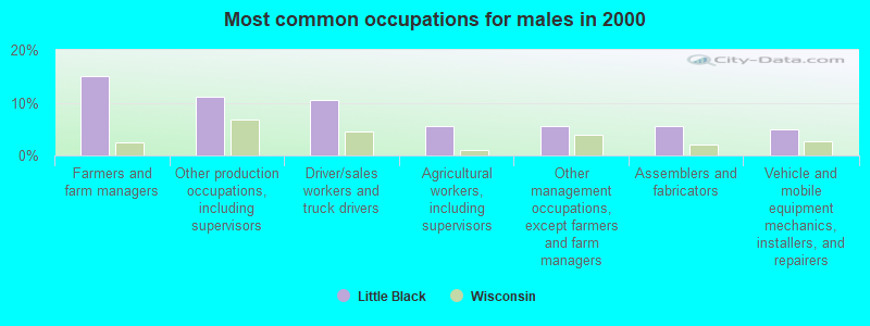
- Farmers and farm managers (15.0%)
- Other production occupations, including supervisors (11.1%)
- Driver/sales workers and truck drivers (10.6%)
- Agricultural workers, including supervisors (5.6%)
- Other management occupations, except farmers and farm managers (5.6%)
- Assemblers and fabricators (5.6%)
- Vehicle and mobile equipment mechanics, installers, and repairers (5.0%)
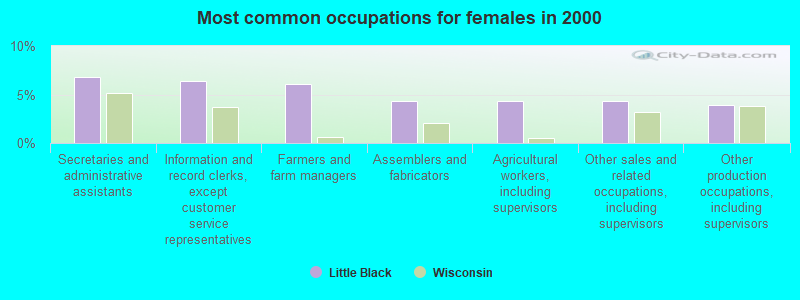
- Secretaries and administrative assistants (6.8%)
- Information and record clerks, except customer service representatives (6.4%)
- Farmers and farm managers (6.1%)
- Assemblers and fabricators (4.3%)
- Agricultural workers, including supervisors (4.3%)
- Other sales and related occupations, including supervisors (4.3%)
- Other production occupations, including supervisors (3.9%)
Average climate in Little Black, Wisconsin
Based on data reported by over 4,000 weather stations


(lower is better)
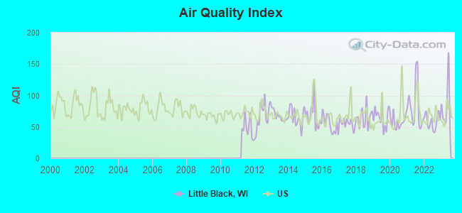
Air Quality Index (AQI) level in 2023 was 82.8. This is about average.
| City: | 82.8 |
| U.S.: | 72.6 |
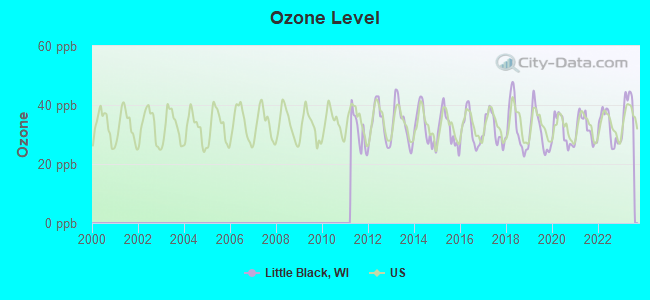
Ozone [ppb] level in 2023 was 39.2. This is about average. Closest monitor was 14.1 miles away from the city center.
| City: | 39.2 |
| U.S.: | 33.3 |
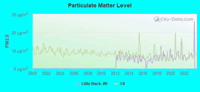
Particulate Matter (PM2.5) [µg/m3] level in 2022 was 6.03. This is better than average. Closest monitor was 14.1 miles away from the city center.
| City: | 6.03 |
| U.S.: | 8.11 |
Tornado activity:
Little Black-area historical tornado activity is slightly below Wisconsin state average. It is 3% smaller than the overall U.S. average.
On 6/4/1958, a category F4 (max. wind speeds 207-260 mph) tornado 19.2 miles away from the Little Black town center killed 4 people and injured 3 people and caused between $500,000 and $5,000,000 in damages.
On 5/10/1953, a category F4 tornado 28.9 miles away from the town center killed 2 people and injured 24 people.
Earthquake activity:
Little Black-area historical earthquake activity is significantly above Wisconsin state average. It is 75% smaller than the overall U.S. average.On 7/9/1975 at 14:54:15, a magnitude 4.6 (4.6 MB, Class: Light, Intensity: IV - V) earthquake occurred 278.6 miles away from Little Black center
On 6/28/2004 at 06:10:52, a magnitude 4.2 (4.2 MW, Depth: 6.2 mi) earthquake occurred 261.2 miles away from the city center
On 2/10/2010 at 09:59:35, a magnitude 3.8 (3.8 MW, Depth: 6.2 mi, Class: Light, Intensity: II - III) earthquake occurred 234.9 miles away from the city center
On 6/5/1993 at 01:24:53, a magnitude 4.1 (4.1 LG, Depth: 6.2 mi) earthquake occurred 290.8 miles away from Little Black center
On 5/2/2015 at 16:23:07, a magnitude 4.2 (4.2 MW, Depth: 2.8 mi) earthquake occurred 315.9 miles away from Little Black center
On 2/7/2020 at 18:30:28, a magnitude 3.3 (3.3 ML) earthquake occurred 200.4 miles away from Little Black center
Magnitude types: regional Lg-wave magnitude (LG), body-wave magnitude (MB), local magnitude (ML), moment magnitude (MW)
Natural disasters:
The number of natural disasters in Taylor County (7) is smaller than the US average (15).Major Disasters (Presidential) Declared: 5
Emergencies Declared: 2
Causes of natural disasters: Floods: 4, Storms: 3, Drought: 1, Hurricane: 1, Tornado: 1, Other: 1 (Note: some incidents may be assigned to more than one category).
Hospitals and medical centers near Little Black:
- MEMORIAL HEALTH CENTER DIALYSIS (Dialysis Facility, about 4 miles away; MEDFORD, WI)
- MEMORIAL NURSING AND REHAB CENTER (Nursing Home, about 4 miles away; MEDFORD, WI)
- GOLDEN LIVINGCENTER-CONTINENTAL MANOR (Nursing Home, about 10 miles away; ABBOTSFORD, WI)
- COLONIAL CENTER (Nursing Home, about 12 miles away; COLBY, WI)
Colleges/universities with over 2000 students nearest to Little Black:
- Northcentral Technical College (about 36 miles; Wausau, WI; Full-time enrollment: 3,356)
- University of Wisconsin-Stevens Point (about 55 miles; Stevens Point, WI; FT enrollment: 9,089)
- Mid-State Technical College (about 56 miles; Wisconsin Rapids, WI; FT enrollment: 2,128)
- University of Wisconsin-Eau Claire (about 59 miles; Eau Claire, WI; FT enrollment: 10,143)
- Chippewa Valley Technical College (about 60 miles; Eau Claire, WI; FT enrollment: 4,038)
- University of Wisconsin-Stout (about 78 miles; Menomonie, WI; FT enrollment: 8,120)
- Wisconsin Indianhead Technical College (about 89 miles; Shell Lake, WI; FT enrollment: 2,414)
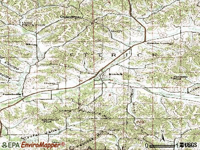
Points of interest:
Cemeteries: Stetsonville Public Cemetery (1), Little Black Cemetery (2), Zion Cemetery (3), Sacred Heart Cemetery (4). Display/hide their locations on the map
Rivers and creeks: Correction Creek (A), Little Black River (B). Display/hide their locations on the map
| This town: | 2.5 people |
| Wisconsin: | 2.4 people |
| This town: | 73.8% |
| Whole state: | 64.4% |
| This town: | 7.3% |
| Whole state: | 7.3% |
Likely homosexual households (counted as self-reported same-sex unmarried-partner households)
- Lesbian couples: 0.7% of all households
- Gay men: 0.2% of all households
| This town: | 8.1% |
| Whole state: | 8.7% |
| This town: | 2.4% |
| Whole state: | 3.7% |
For population 15 years and over in Little Black:
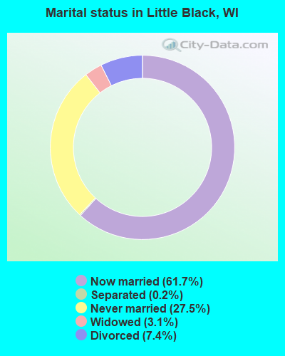
- Never married: 27.5%
- Now married: 61.7%
- Separated: 0.2%
- Widowed: 3.1%
- Divorced: 7.4%
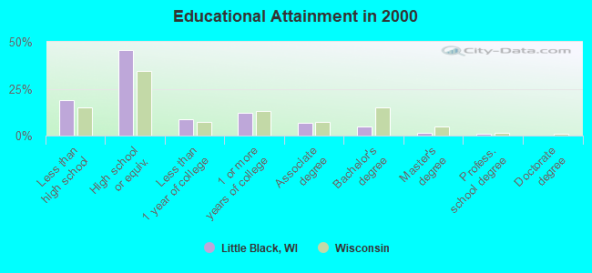
For population 25 years and over in Little Black:
- High school or higher: 81.0%
- Bachelor's degree or higher: 7.5%
- Graduate or professional degree: 2.8%
- Unemployed: 2.0%
- Mean travel time to work (commute): 17.0 minutes
| Here: | 9.5 |
| Wisconsin average: | 11.0 |

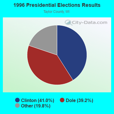
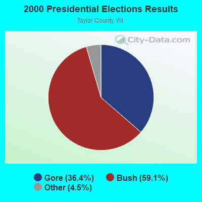
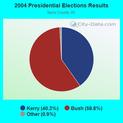
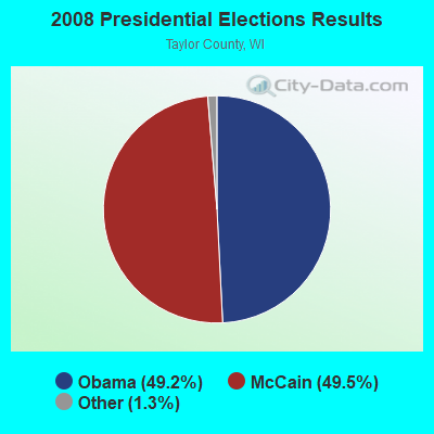
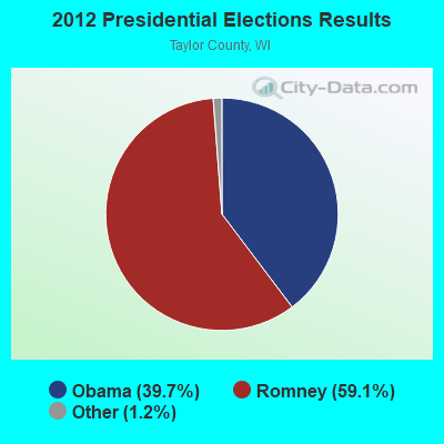

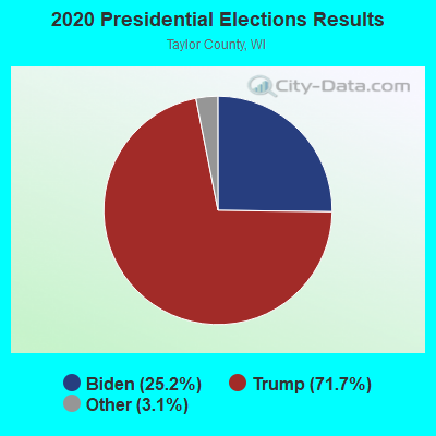
Graphs represent county-level data. Detailed 2008 Election Results
Religion statistics for Little Black, WI (based on Taylor County data)
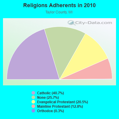
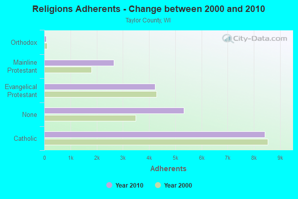
| Religion | Adherents | Congregations |
|---|---|---|
| Catholic | 8,417 | 8 |
| Evangelical Protestant | 4,231 | 19 |
| Mainline Protestant | 2,644 | 9 |
| Orthodox | 70 | 1 |
| Other | 1 | - |
| None | 5,326 | - |
Food Environment Statistics:
| Taylor County: | 1.56 / 10,000 pop. |
| Wisconsin: | 1.86 / 10,000 pop. |
| Taylor County: | 1.04 / 10,000 pop. |
| Wisconsin: | 0.38 / 10,000 pop. |
| Taylor County: | 5.18 / 10,000 pop. |
| State: | 4.12 / 10,000 pop. |
| Taylor County: | 6.74 / 10,000 pop. |
| State: | 8.64 / 10,000 pop. |
| This county: | 7.7% |
| Wisconsin: | 7.6% |
| This county: | 27.1% |
| State: | 27.5% |
| Taylor County: | 10.1% |
| State: | 13.0% |
Strongest AM radio stations in Little Black:
- WIGM (1490 AM; 1 kW; MEDFORD, WI; Owner: W I G M, INC.)
- WSAU (550 AM; 20 kW; WAUSAU, WI; Owner: WRIG, INC.)
- WSPT (1010 AM; 50 kW; STEVENS POINT, WI)
- WRIG (1390 AM; 10 kW; SCHOFIELD, WI; Owner: WRIG, INC.)
- WEBC (560 AM; 50 kW; DULUTH, MN)
- WLBL (930 AM; 5 kW; AUBURNDALE, WI; Owner: STATE OF WISCONSIN - EDUCATIONAL COMMUNICATIONS BOARD)
- WNAM (1280 AM; 50 kW; NEENAH-MENASHA, WI; Owner: CUMULUS LICENSING CORP.)
- WCTS (1030 AM; 50 kW; MAPLEWOOD, MN; Owner: CNTL. BAPT. THEO/AL SEMI MINNEAPOLIS)
- WCCO (830 AM; 50 kW; MINNEAPOLIS, MN; Owner: INFINITY MEDIA CORPORATION)
- WCCN (1370 AM; 5 kW; NEILLSVILLE, WI; Owner: CENTRAL WISCONSIN BROADCASTING, INC.)
- WMEQ (880 AM; 10 kW; MENOMONIE, WI; Owner: CAPSTAR TX LIMITED PARTNERSHIP)
- KSTP (1500 AM; 50 kW; ST. PAUL, MN; Owner: KSTP-AM, LLC (DELAWARE))
- WAYY (790 AM; 5 kW; EAU CLAIRE, WI; Owner: MAVERICK MEDIA OF EAU CLAIRE LICENSE LLC)
Strongest FM radio stations in Little Black:
- WKEB (99.3 FM; MEDFORD, WI; Owner: WIGM, INCORPORATED)
- WAXX (104.5 FM; EAU CLAIRE, WI; Owner: MAVERICK MEDIA OF EAU CLAIRE LICENSE LLC)
- WDEZ (101.9 FM; WAUSAU, WI; Owner: W R I G, INC.)
- WHRM (90.9 FM; WAUSAU, WI; Owner: STATE OF WISCONSIN - EDUCATIONAL COMMUNICATIONS BOARD)
- WOFM (94.7 FM; MOSINEE, WI; Owner: WRIG, INC.)
- WIFC (95.5 FM; WAUSAU, WI; Owner: WRIG, INC.)
- WWIB (103.7 FM; HALLIE, WI; Owner: STEWARDS OF SOUND, INC.)
- WLBL-FM (91.9 FM; WAUSAU, WI; Owner: STATE OF WISCONSIN - EDUCATIONAL COMMUNICATIONS BOARD)
- WXPW (91.9 FM; WAUSAU, WI; Owner: WHITE PINE COMMUNITY BROADCASTING, INC)
- WMZK (104.1 FM; MERRILL, WI; Owner: ROBERTS BROADCASTING, INC.)
- WLJY (106.5 FM; MARSHFIELD, WI; Owner: NEWRADIO GROUP, LLC)
- WOSQ (92.3 FM; SPENCER, WI; Owner: NEWRADIO GROUP, LLC)
TV broadcast stations around Little Black:
- WEAU-TV (Channel 13; EAU CLAIRE, WI; Owner: WEAU LICENSEE CORP.)
- WAOW-TV (Channel 9; WAUSAU, WI; Owner: WAOW-WYOW TELEVISION, INC.)
- WHRM-TV (Channel 20; WAUSAU, WI; Owner: STATE OF WISCONSIN - EDUCATIONAL COMMUNICATIONS BOARD)
- National Bridge Inventory (NBI) Statistics
- 11Number of bridges
- 72ft / 22.2mTotal length
- $416,000Total costs
- 8,644Total average daily traffic
- 568Total average daily truck traffic
- 10,213Total future (year 2035) average daily traffic
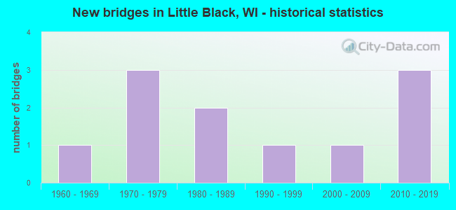
- New bridges - historical statistics
- 11960-1969
- 31970-1979
- 21980-1989
- 11990-1999
- 12000-2009
- 32010-2019
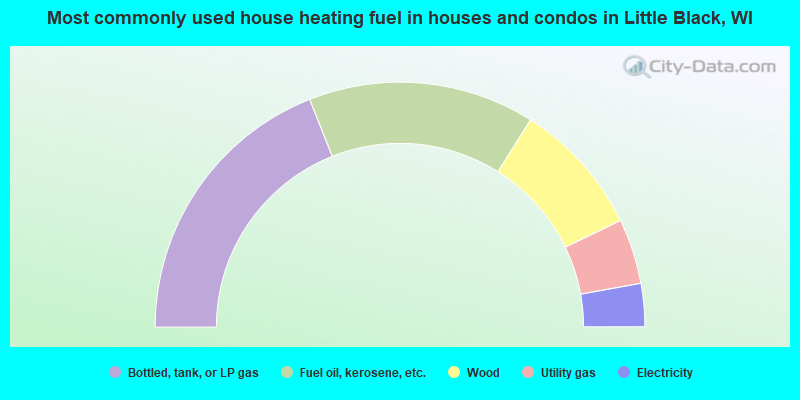
- 38.0%Bottled, tank, or LP gas
- 29.9%Fuel oil, kerosene, etc.
- 17.8%Wood
- 8.6%Utility gas
- 5.7%Electricity
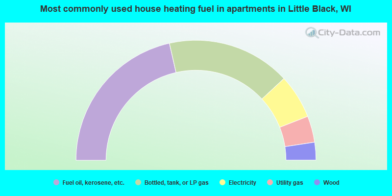
- 42.9%Fuel oil, kerosene, etc.
- 33.3%Bottled, tank, or LP gas
- 11.9%Electricity
- 7.1%Utility gas
- 4.8%Wood
Little Black compared to Wisconsin state average:
- Unemployed percentage significantly below state average.
- Black race population percentage significantly below state average.
- Hispanic race population percentage significantly below state average.
- Foreign-born population percentage significantly below state average.
- Renting percentage significantly below state average.
- Length of stay since moving in significantly above state average.
- Number of rooms per house significantly below state average.
- House age significantly below state average.
- Number of college students significantly below state average.
- Percentage of population with a bachelor's degree or higher significantly below state average.