Browning, Wisconsin
Submit your own pictures of this town and show them to the world
- OSM Map
- Google Map
- MSN Map
Population change since 2000: +6.5%
 |
| Males: 482 | |
| Females: 423 |
| Median resident age: | 38.8 years |
| Wisconsin median age: | 42.6 years |
Zip codes: 54451.
| Browning: | $71,701 |
| WI: | $70,996 |
Estimated per capita income in 2022: $35,014 (it was $18,687 in 2000)
Browning town income, earnings, and wages data
Estimated median house or condo value in 2022: $198,218 (it was $84,700 in 2000)
| Browning: | $198,218 |
| WI: | $252,800 |
Mean prices in 2022: all housing units: $225,755; detached houses: $237,087; townhouses or other attached units: $201,679; in 2-unit structures: $217,833; in 3-to-4-unit structures: $267,787; mobile homes: $86,490
Detailed information about poverty and poor residents in Browning, WI


- 85194.0%White alone
- 485.3%Hispanic
- 50.6%Two or more races
- 10.1%Black alone

Races in Browning detailed stats: ancestries, foreign born residents, place of birth
 Recent articles from our blog. Our writers, many of them Ph.D. graduates or candidates, create easy-to-read articles on a wide variety of topics.
Ancestries: German (62.6%), Polish (9.6%), United States (9.3%), Norwegian (7.9%), Irish (5.3%), Czech (4.7%).
Current Local Time: CST time zone
Land area: 36.5 square miles.
Population density: 25 people per square mile (very low).
21 residents are foreign born (2.2% Latin America).
| This town: | 2.5% |
| Wisconsin: | 3.6% |
| Browning town: | 1.5% ($1,296) |
| Wisconsin: | 2.0% ($2,245) |
Nearest city with pop. 50,000+: Eau Claire, WI  (66.3 miles , pop. 61,704).
Nearest city with pop. 200,000+: St. Paul, MN (141.5 miles , pop. 287,151).
Nearest city with pop. 1,000,000+: Chicago, IL (263.3 miles , pop. 2,896,016).
Nearest cities:
), ), ), ), ), )Latitude: 45.17 N, Longitude: 90.23 W
Area code commonly used in this area: 715

Single-family new house construction building permits:
- 2021: 2 buildings, average cost: $275,000
- 2020: 4 buildings, average cost: $188,800
- 2019: 1 building, cost: $180,000
- 2018: 4 buildings, average cost: $175,000
- 2016: 2 buildings, average cost: $160,500
- 2015: 2 buildings, average cost: $170,000
- 2014: 2 buildings, average cost: $170,000
- 2013: 4 buildings, average cost: $175,000
- 2012: 3 buildings, average cost: $135,000
- 2010: 2 buildings, average cost: $170,100
- 2009: 1 building, cost: $300,000
- 2008: 3 buildings, average cost: $113,700
- 2006: 3 buildings, average cost: $205,000
- 2005: 6 buildings, average cost: $136,700
- 2003: 2 buildings, average cost: $62,500
- 2002: 4 buildings, average cost: $57,500
- 2001: 7 buildings, average cost: $78,700
- 2000: 5 buildings, average cost: $76,000
- 1999: 8 buildings, average cost: $76,500
- 1998: 4 buildings, average cost: $93,000
- 1997: 6 buildings, average cost: $78,100


| Here: | 4.1% |
| Wisconsin: | 2.7% |

- Agriculture, forestry, fishing & hunting (17.6%)
- Wood products (12.8%)
- Accommodation & food services (6.9%)
- Plastics & rubber products (6.1%)
- Food (4.7%)
- Food & beverage stores (4.0%)
- Health care (3.8%)

- Agriculture, forestry, fishing & hunting (23.8%)
- Wood products (12.7%)
- Construction (7.1%)
- Truck transportation (4.8%)
- Furniture & related product manufacturing (4.8%)
- Plastics & rubber products (4.8%)
- Food (4.0%)

- Wood products (12.8%)
- Agriculture, forestry, fishing & hunting (11.2%)
- Accommodation & food services (10.3%)
- Plastics & rubber products (7.4%)
- Health care (6.2%)
- Food (5.4%)
- Finance & insurance (5.4%)

- Other production occupations, including supervisors (11.5%)
- Farmers and farm managers (11.1%)
- Assemblers and fabricators (6.9%)
- Agricultural workers, including supervisors (4.9%)
- Other sales and related occupations, including supervisors (3.8%)
- Metal workers and plastic workers (3.8%)
- Vehicle and mobile equipment mechanics, installers, and repairers (3.4%)

- Other production occupations, including supervisors (14.3%)
- Farmers and farm managers (13.9%)
- Agricultural workers, including supervisors (7.5%)
- Vehicle and mobile equipment mechanics, installers, and repairers (6.7%)
- Assemblers and fabricators (6.0%)
- Other sales and related occupations, including supervisors (4.8%)
- Driver/sales workers and truck drivers (4.8%)

- Other production occupations, including supervisors (8.7%)
- Farmers and farm managers (8.3%)
- Assemblers and fabricators (7.9%)
- Waiters and waitresses (5.8%)
- Other office and administrative support workers, including supervisors (5.8%)
- Cashiers (5.4%)
- Secretaries and administrative assistants (5.4%)
Average climate in Browning, Wisconsin
Based on data reported by over 4,000 weather stations


(lower is better)

Air Quality Index (AQI) level in 2023 was 82.8. This is about average.
| City: | 82.8 |
| U.S.: | 72.6 |

Ozone [ppb] level in 2023 was 39.2. This is about average. Closest monitor was 18.0 miles away from the city center.
| City: | 39.2 |
| U.S.: | 33.3 |

Particulate Matter (PM2.5) [µg/m3] level in 2022 was 6.03. This is better than average. Closest monitor was 18.0 miles away from the city center.
| City: | 6.03 |
| U.S.: | 8.11 |
Tornado activity:
Browning-area historical tornado activity is slightly below Wisconsin state average. It is 8% smaller than the overall U.S. average.
On 6/4/1958, a category F4 (max. wind speeds 207-260 mph) tornado 20.1 miles away from the Browning town center killed 4 people and injured 3 people and caused between $500,000 and $5,000,000 in damages.
On 5/10/1953, a category F4 tornado 24.8 miles away from the town center killed 2 people and injured 24 people.
Earthquake activity:
Browning-area historical earthquake activity is significantly above Wisconsin state average. It is 75% smaller than the overall U.S. average.On 7/9/1975 at 14:54:15, a magnitude 4.6 (4.6 MB, Class: Light, Intensity: IV - V) earthquake occurred 284.1 miles away from the city center
On 6/28/2004 at 06:10:52, a magnitude 4.2 (4.2 MW, Depth: 6.2 mi) earthquake occurred 265.0 miles away from Browning center
On 2/10/2010 at 09:59:35, a magnitude 3.8 (3.8 MW, Depth: 6.2 mi, Class: Light, Intensity: II - III) earthquake occurred 237.6 miles away from Browning center
On 6/5/1993 at 01:24:53, a magnitude 4.1 (4.1 LG, Depth: 6.2 mi) earthquake occurred 296.2 miles away from the city center
On 5/2/2015 at 16:23:07, a magnitude 4.2 (4.2 MW, Depth: 2.8 mi) earthquake occurred 314.2 miles away from Browning center
On 2/7/2020 at 18:30:28, a magnitude 3.3 (3.3 ML) earthquake occurred 199.4 miles away from Browning center
Magnitude types: regional Lg-wave magnitude (LG), body-wave magnitude (MB), local magnitude (ML), moment magnitude (MW)
Natural disasters:
The number of natural disasters in Taylor County (7) is smaller than the US average (15).Major Disasters (Presidential) Declared: 5
Emergencies Declared: 2
Causes of natural disasters: Floods: 4, Storms: 3, Drought: 1, Hurricane: 1, Tornado: 1, Other: 1 (Note: some incidents may be assigned to more than one category).
Hospitals and medical centers near Browning:
- MEMORIAL HEALTH CENTER DIALYSIS (Dialysis Facility, about 7 miles away; MEDFORD, WI)
- MEMORIAL NURSING AND REHAB CENTER (Nursing Home, about 7 miles away; MEDFORD, WI)
- GOLDEN LIVINGCENTER-RIB LAKE (Nursing Home, about 11 miles away; RIB LAKE, WI)
- GOLDEN LIVINGCENTER-CONTINENTAL MANOR (Nursing Home, about 16 miles away; ABBOTSFORD, WI)
Colleges/universities with over 2000 students nearest to Browning:
- Northcentral Technical College (about 32 miles; Wausau, WI; Full-time enrollment: 3,356)
- University of Wisconsin-Stevens Point (about 55 miles; Stevens Point, WI; FT enrollment: 9,089)
- Mid-State Technical College (about 58 miles; Wisconsin Rapids, WI; FT enrollment: 2,128)
- University of Wisconsin-Eau Claire (about 68 miles; Eau Claire, WI; FT enrollment: 10,143)
- Chippewa Valley Technical College (about 68 miles; Eau Claire, WI; FT enrollment: 4,038)
- University of Wisconsin-Stout (about 86 miles; Menomonie, WI; FT enrollment: 8,120)
- Wisconsin Indianhead Technical College (about 92 miles; Shell Lake, WI; FT enrollment: 2,414)
Points of interest:
Reservoir: 0.1 Reservoir (A). Display/hide its location on the map
Rivers: West Branch Little Black River (A), East Branch Little Black River (B). Display/hide their locations on the map
| This town: | 2.7 people |
| Wisconsin: | 2.4 people |
| This town: | 80.2% |
| Whole state: | 64.4% |
| This town: | 6.0% |
| Whole state: | 7.3% |
Likely homosexual households (counted as self-reported same-sex unmarried-partner households)
- Lesbian couples: 0.0% of all households
- Gay men: 0.3% of all households
| This town: | 5.9% |
| Whole state: | 8.7% |
| This town: | 0.8% |
| Whole state: | 3.7% |
For population 15 years and over in Browning:

- Never married: 23.4%
- Now married: 64.7%
- Separated: 0.4%
- Widowed: 2.8%
- Divorced: 8.7%
For population 25 years and over in Browning:
- High school or higher: 79.4%
- Bachelor's degree or higher: 9.9%
- Graduate or professional degree: 1.5%
- Unemployed: 6.1%
- Mean travel time to work (commute): 18.6 minutes


| Here: | 9.1 |
| Wisconsin average: | 11.0 |

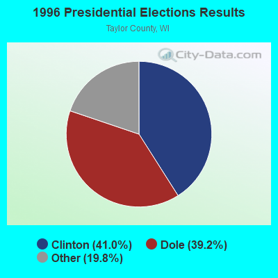
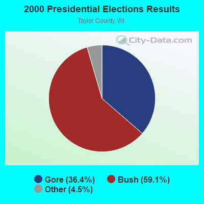
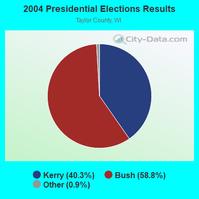
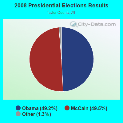
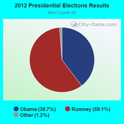

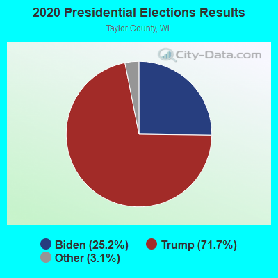
Graphs represent county-level data. Detailed 2008 Election Results
Religion statistics for Browning, WI (based on Taylor County data)
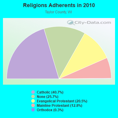
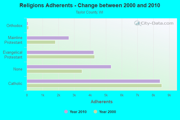
| Religion | Adherents | Congregations |
|---|---|---|
| Catholic | 8,417 | 8 |
| Evangelical Protestant | 4,231 | 19 |
| Mainline Protestant | 2,644 | 9 |
| Orthodox | 70 | 1 |
| Other | 1 | - |
| None | 5,326 | - |
Food Environment Statistics:
| Taylor County: | 1.56 / 10,000 pop. |
| State: | 1.86 / 10,000 pop. |
| This county: | 1.04 / 10,000 pop. |
| State: | 0.38 / 10,000 pop. |
| Taylor County: | 5.18 / 10,000 pop. |
| Wisconsin: | 4.12 / 10,000 pop. |
| This county: | 6.74 / 10,000 pop. |
| Wisconsin: | 8.64 / 10,000 pop. |
| Taylor County: | 7.7% |
| State: | 7.6% |
| Taylor County: | 27.1% |
| State: | 27.5% |
| Taylor County: | 10.1% |
| State: | 13.0% |
Strongest AM radio stations in Browning:
- WIGM (1490 AM; 1 kW; MEDFORD, WI; Owner: W I G M, INC.)
- WSAU (550 AM; 20 kW; WAUSAU, WI; Owner: WRIG, INC.)
- WSPT (1010 AM; 50 kW; STEVENS POINT, WI)
- WRIG (1390 AM; 10 kW; SCHOFIELD, WI; Owner: WRIG, INC.)
- WEBC (560 AM; 50 kW; DULUTH, MN)
- WLBL (930 AM; 5 kW; AUBURNDALE, WI; Owner: STATE OF WISCONSIN - EDUCATIONAL COMMUNICATIONS BOARD)
- WNAM (1280 AM; 50 kW; NEENAH-MENASHA, WI; Owner: CUMULUS LICENSING CORP.)
- WCTS (1030 AM; 50 kW; MAPLEWOOD, MN; Owner: CNTL. BAPT. THEO/AL SEMI MINNEAPOLIS)
- WCCO (830 AM; 50 kW; MINNEAPOLIS, MN; Owner: INFINITY MEDIA CORPORATION)
- WTMJ (620 AM; 50 kW; MILWAUKEE, WI; Owner: JOURNAL BROADCAST CORPORATION)
- WCCN (1370 AM; 5 kW; NEILLSVILLE, WI; Owner: CENTRAL WISCONSIN BROADCASTING, INC.)
- WHBY (1150 AM; 25 kW; KIMBERLY, WI; Owner: WOODWARD COMMUNICATIONS, INC.)
- KSTP (1500 AM; 50 kW; ST. PAUL, MN; Owner: KSTP-AM, LLC (DELAWARE))
Strongest FM radio stations in Browning:
- WKEB (99.3 FM; MEDFORD, WI; Owner: WIGM, INCORPORATED)
- WDEZ (101.9 FM; WAUSAU, WI; Owner: W R I G, INC.)
- WOFM (94.7 FM; MOSINEE, WI; Owner: WRIG, INC.)
- WHRM (90.9 FM; WAUSAU, WI; Owner: STATE OF WISCONSIN - EDUCATIONAL COMMUNICATIONS BOARD)
- WIFC (95.5 FM; WAUSAU, WI; Owner: WRIG, INC.)
- WAXX (104.5 FM; EAU CLAIRE, WI; Owner: MAVERICK MEDIA OF EAU CLAIRE LICENSE LLC)
- WLBL-FM (91.9 FM; WAUSAU, WI; Owner: STATE OF WISCONSIN - EDUCATIONAL COMMUNICATIONS BOARD)
- WXPW (91.9 FM; WAUSAU, WI; Owner: WHITE PINE COMMUNITY BROADCASTING, INC)
- WMZK (104.1 FM; MERRILL, WI; Owner: ROBERTS BROADCASTING, INC.)
- WYCO (107.9 FM; WAUSAU, WI; Owner: SEEHAFER BROADCASTING CORPORATION)
- WWIB (103.7 FM; HALLIE, WI; Owner: STEWARDS OF SOUND, INC.)
- WCLQ (89.5 FM; WAUSAU, WI; Owner: CHRISTIAN LIFE COMMUNICATIONS, INC.)
TV broadcast stations around Browning:
- WEAU-TV (Channel 13; EAU CLAIRE, WI; Owner: WEAU LICENSEE CORP.)
- WYOW (Channel 34; EAGLE RIVER, WI; Owner: WAOW-WYOW TELEVISION, INC.)
- WAOW-TV (Channel 9; WAUSAU, WI; Owner: WAOW-WYOW TELEVISION, INC.)
- WSAW-TV (Channel 7; WAUSAU, WI; Owner: GRAY MIDAMERICA TV LICENSEE CORP.)
- WFXS (Channel 55; WITTENBERG, WI; Owner: DAVIS TELEVISION WAUSAU, LLC)
- WLEF-TV (Channel 36; PARK FALLS, WI; Owner: STATE OF WISCONSIN - EDUCATIONAL COMMUNICATIONS BOARD)
- WHRM-TV (Channel 20; WAUSAU, WI; Owner: STATE OF WISCONSIN - EDUCATIONAL COMMUNICATIONS BOARD)
- National Bridge Inventory (NBI) Statistics
- 11Number of bridges
- 49ft / 14.9mTotal length
- $290,000Total costs
- 3,252Total average daily traffic
- 294Total average daily truck traffic
- 3,730Total future (year 2038) average daily traffic

- New bridges - historical statistics
- 11910-1919
- 11940-1949
- 21950-1959
- 21960-1969
- 11970-1979
- 21980-1989
- 12000-2009
- 12010-2019

- 44.1%Bottled, tank, or LP gas
- 25.7%Wood
- 23.9%Fuel oil, kerosene, etc.
- 6.2%Electricity

- 44.8%Fuel oil, kerosene, etc.
- 20.7%Wood
- 17.2%Utility gas
- 13.8%Bottled, tank, or LP gas
- 3.4%Electricity
Browning compared to Wisconsin state average:
- Unemployed percentage below state average.
- Black race population percentage significantly below state average.
- Foreign-born population percentage below state average.
- Renting percentage below state average.
- Length of stay since moving in significantly above state average.
- Number of rooms per house significantly below state average.
- House age significantly below state average.
- Number of college students below state average.
- Percentage of population with a bachelor's degree or higher significantly below state average.