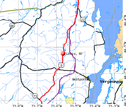
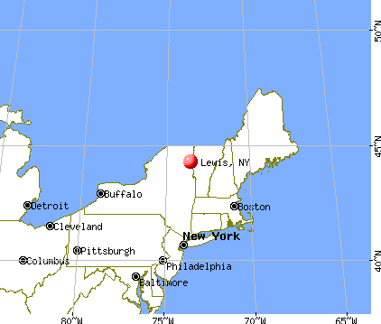
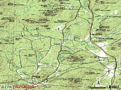
Lewis, New York
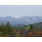
Lewis: A few miles from Lewis
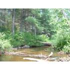
Lewis: Camp on Spruce Mill Brook in Lewis
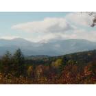
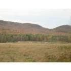
Lewis: View of Giant Mountain from my home
Lewis: Lewis, New York
Lewis: Pulsifer Road Sports Field & Carson Ledges
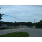
Lewis: Betty Beaver's Truck Stop near I-87
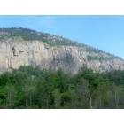
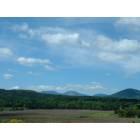
Lewis: Mointain near I-87 in Lewis Area
- add
your
Submit your own pictures of this town and show them to the world
- OSM Map
- General Map
- Google Map
- MSN Map
Population change since 2000: +15.2%
| Males: 715 | |
| Females: 667 |
| Median resident age: | 44.0 years |
| New York median age: | 40.7 years |
Zip codes: 12950.
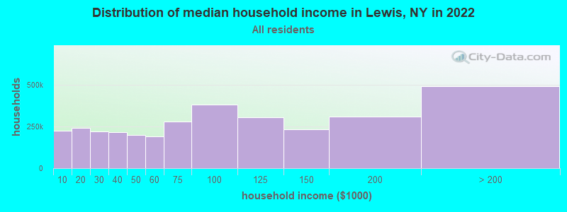
| Lewis: | $70,243 |
| NY: | $79,557 |
Estimated per capita income in 2022: $36,743 (it was $17,030 in 2000)
Lewis town income, earnings, and wages data
Estimated median house or condo value in 2022: $184,938 (it was $71,900 in 2000)
| Lewis: | $184,938 |
| NY: | $400,400 |
Mean prices in 2022: all housing units: $276,108; detached houses: $284,996; townhouses or other attached units: $274,370; in 2-unit structures: $811,609; in 3-to-4-unit structures: $406,202; in 5-or-more-unit structures: $398,648; mobile homes: $92,731
Detailed information about poverty and poor residents in Lewis, NY


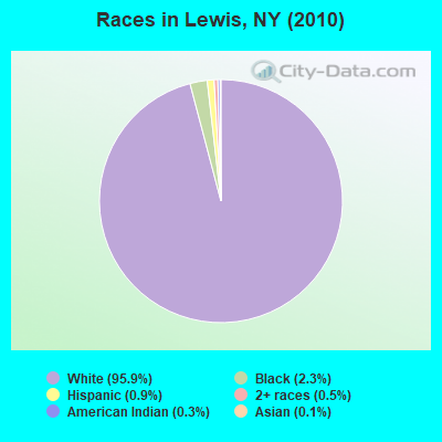
- 1,32595.9%White alone
- 322.3%Black alone
- 120.9%Hispanic
- 70.5%Two or more races
- 40.3%American Indian alone
- 20.1%Asian alone
Races in Lewis detailed stats: ancestries, foreign born residents, place of birth
According to our research of New York and other state lists, there were 2 registered sex offenders living in Lewis, New York as of May 09, 2024.
The ratio of all residents to sex offenders in Lewis is 691 to 1.
 Recent articles from our blog. Our writers, many of them Ph.D. graduates or candidates, create easy-to-read articles on a wide variety of topics.

 | smaller Upstate NY cities and towns/African American communities (5974 replies) |
| Auburn area development, events, news, etc. (253 replies) |
| Killer of Karina Vetrano Seeks To Have His Conviction Overturned (148 replies) |
| Inno has arrived in Albany. Here's what to expect... (104 replies) |
| For those interested in Technology and Economic activity in Upstate NY... (2811 replies) |
| Good neighborhoods in Watertown NY?? (45 replies) |
Latest news from Lewis, NY collected exclusively by city-data.com from local newspapers, TV, and radio stations
Ancestries: French (31.6%), Irish (20.8%), English (18.3%), United States (11.4%), German (9.6%), Italian (5.2%).
Current Local Time: EST time zone
Land area: 84.8 square miles.
Population density: 16 people per square mile (very low).
18 residents are foreign born
| This town: | 1.5% |
| New York: | 20.4% |
| Lewis town: | 1.6% ($1,177) |
| New York: | 1.9% ($2,847) |
Nearest city with pop. 50,000+: Schenectady, NY  (104.1 miles , pop. 61,821).
Nearest city with pop. 200,000+: Boston, MA (183.5 miles , pop. 589,141).
Nearest city with pop. 1,000,000+: Bronx, NY (238.2 miles , pop. 1,332,650).
Nearest cities:
), ), )Latitude: 44.28 N, Longitude: 73.55 W
Area code commonly used in this area: 518

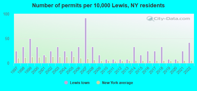
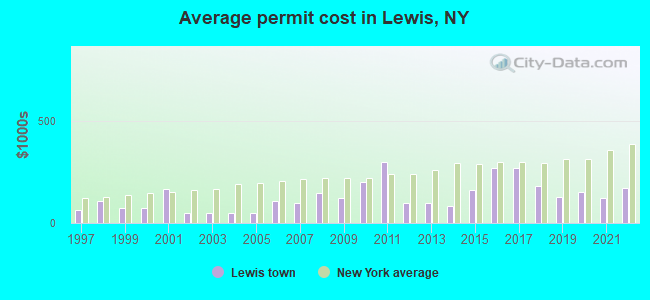
Single-family new house construction building permits:
- 2022: 5 buildings, average cost: $170,000
- 2021: 3 buildings, average cost: $123,000
- 2020: 1 building, cost: $150,000
- 2019: 1 building, cost: $125,000
- 2018: 4 buildings, average cost: $181,300
- 2017: 3 buildings, average cost: $266,700
- 2016: 3 buildings, average cost: $266,700
- 2015: 2 buildings, average cost: $162,500
- 2014: 4 buildings, average cost: $82,800
- 2013: 1 building, cost: $100,000
- 2012: 1 building, cost: $100,000
- 2011: 1 building, cost: $300,000
- 2010: 1 building, cost: $200,000
- 2009: 2 buildings, average cost: $120,000
- 2008: 4 buildings, average cost: $146,300
- 2007: 11 buildings, average cost: $97,000
- 2006: 4 buildings, average cost: $107,800
- 2005: 3 buildings, average cost: $50,000
- 2004: 3 buildings, average cost: $50,000
- 2003: 4 buildings, average cost: $50,000
- 2002: 3 buildings, average cost: $50,000
- 2001: 2 buildings, average cost: $167,500
- 2000: 4 buildings, average cost: $70,600
- 1999: 6 buildings, average cost: $71,300
- 1998: 4 buildings, average cost: $108,600
- 1997: 3 buildings, average cost: $63,200
| Here: | 4.7% |
| New York: | 4.4% |
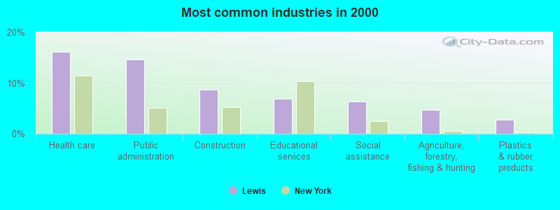
- Health care (16.2%)
- Public administration (14.7%)
- Construction (8.6%)
- Educational services (7.0%)
- Social assistance (6.4%)
- Agriculture, forestry, fishing & hunting (4.7%)
- Plastics & rubber products (2.8%)
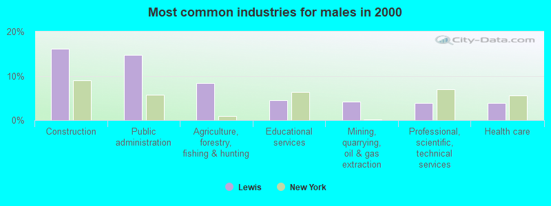
- Construction (16.1%)
- Public administration (14.7%)
- Agriculture, forestry, fishing & hunting (8.4%)
- Educational services (4.6%)
- Mining, quarrying, oil & gas extraction (4.2%)
- Professional, scientific, technical services (3.9%)
- Health care (3.9%)
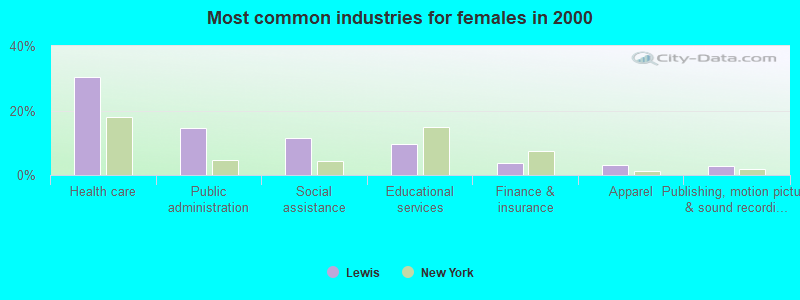
- Health care (30.4%)
- Public administration (14.6%)
- Social assistance (11.3%)
- Educational services (9.7%)
- Finance & insurance (3.6%)
- Apparel (3.2%)
- Publishing, motion picture & sound recording industries (2.8%)

- Building and grounds cleaning and maintenance occupations (5.5%)
- Other management occupations, except farmers and farm managers (5.3%)
- Other production occupations, including supervisors (4.7%)
- Law enforcement workers, including supervisors (4.5%)
- Counselors, social workers, and other community and social service specialists (4.1%)
- Nursing, psychiatric, and home health aides (3.4%)
- Preschool, kindergarten, elementary, and middle school teachers (3.4%)
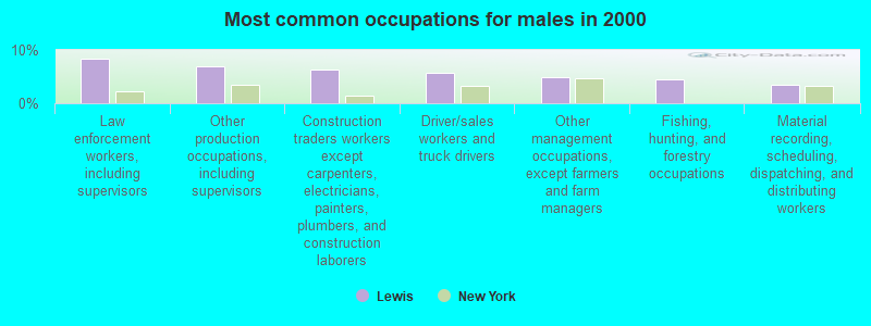
- Law enforcement workers, including supervisors (8.4%)
- Other production occupations, including supervisors (7.0%)
- Construction traders workers except carpenters, electricians, painters, plumbers, and construction laborers (6.3%)
- Driver/sales workers and truck drivers (5.6%)
- Other management occupations, except farmers and farm managers (4.9%)
- Fishing, hunting, and forestry occupations (4.6%)
- Material recording, scheduling, dispatching, and distributing workers (3.5%)
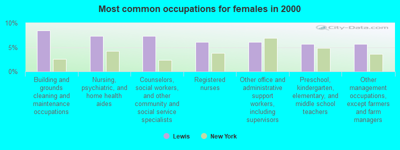
- Building and grounds cleaning and maintenance occupations (8.5%)
- Nursing, psychiatric, and home health aides (7.3%)
- Counselors, social workers, and other community and social service specialists (7.3%)
- Registered nurses (6.1%)
- Other office and administrative support workers, including supervisors (6.1%)
- Preschool, kindergarten, elementary, and middle school teachers (5.7%)
- Other management occupations, except farmers and farm managers (5.7%)
Average climate in Lewis, New York
Based on data reported by over 4,000 weather stations


(lower is better)
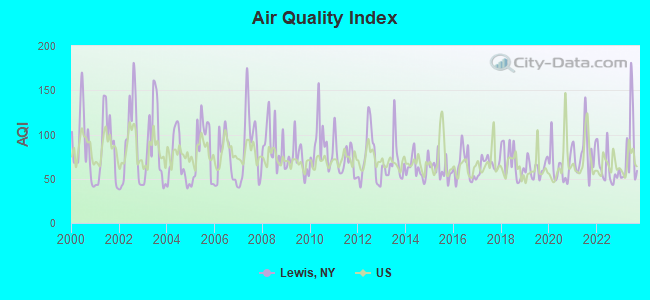
Air Quality Index (AQI) level in 2023 was 80.9. This is about average.
| City: | 80.9 |
| U.S.: | 72.6 |
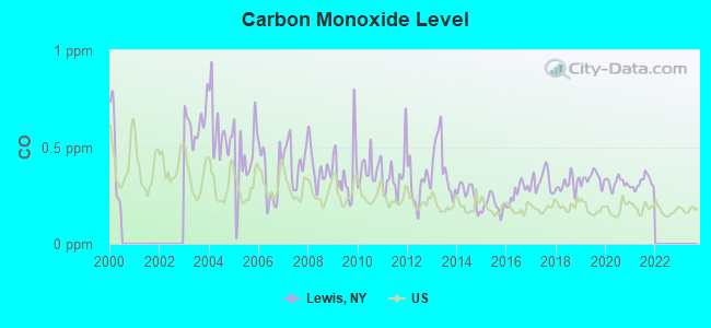
Carbon Monoxide (CO) [ppm] level in 2021 was 0.317. This is worse than average. Closest monitor was 21.3 miles away from the city center.
| City: | 0.317 |
| U.S.: | 0.251 |
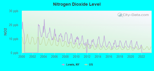
Nitrogen Dioxide (NO2) [ppb] level in 2021 was 4.81. This is about average. Closest monitor was 21.3 miles away from the city center.
| City: | 4.81 |
| U.S.: | 5.11 |
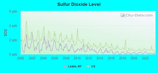
Sulfur Dioxide (SO2) [ppb] level in 2023 was 0.100. This is significantly better than average. Closest monitor was 17.3 miles away from the city center.
| City: | 0.100 |
| U.S.: | 1.515 |
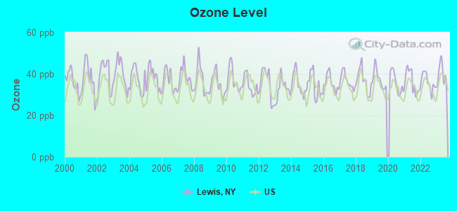
Ozone [ppb] level in 2023 was 39.5. This is about average. Closest monitor was 17.3 miles away from the city center.
| City: | 39.5 |
| U.S.: | 33.3 |
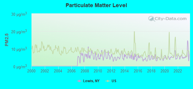
Particulate Matter (PM2.5) [µg/m3] level in 2023 was 7.03. This is about average. Closest monitor was 17.3 miles away from the city center.
| City: | 7.03 |
| U.S.: | 8.11 |
Earthquake activity:
Lewis-area historical earthquake activity is significantly above New York state average. It is 70% smaller than the overall U.S. average.On 4/20/2002 at 10:50:47, a magnitude 5.3 (5.3 ML, Depth: 3.0 mi, Class: Moderate, Intensity: VI - VII) earthquake occurred 17.6 miles away from Lewis center
On 4/20/2002 at 10:50:47, a magnitude 5.2 (5.2 MB, 4.2 MS, 5.2 MW, 5.0 MW) earthquake occurred 16.5 miles away from Lewis center
On 10/7/1983 at 10:18:46, a magnitude 5.3 (5.1 MB, 5.3 LG, 5.1 ML) earthquake occurred 45.7 miles away from the city center
On 1/19/1982 at 00:14:42, a magnitude 4.7 (4.5 MB, 4.7 MD, 4.5 LG, Class: Light, Intensity: IV - V) earthquake occurred 111.1 miles away from the city center
On 10/16/2012 at 23:12:25, a magnitude 4.7 (4.7 ML, Depth: 10.0 mi) earthquake occurred 151.5 miles away from the city center
On 4/20/2002 at 11:04:42, a magnitude 3.7 (3.7 ML, Depth: 3.1 mi, Class: Light, Intensity: II - III) earthquake occurred 16.0 miles away from Lewis center
Magnitude types: regional Lg-wave magnitude (LG), body-wave magnitude (MB), duration magnitude (MD), local magnitude (ML), surface-wave magnitude (MS), moment magnitude (MW)
Natural disasters:
The number of natural disasters in Essex County (19) is greater than the US average (15).Major Disasters (Presidential) Declared: 12
Emergencies Declared: 5
Causes of natural disasters: Storms: 8, Floods: 7, Hurricanes: 4, Winds: 2, Winter Storms: 2, Blizzard: 1, Earthquake: 1, Power Outage: 1, Snowstorm: 1, Tornado: 1, Other: 2 (Note: some incidents may be assigned to more than one category).
Amtrak stations near Lewis:
- 9 miles: WESTPORT (HWY. 9 N. & D&H RAILROAD TRACKS) . Services: enclosed waiting area, public restrooms, public payphones, free short-term parking, free long-term parking.
- 18 miles: PORT HENRY (RTE. 9 NORTH & RTE. 22) . Services: enclosed waiting area, public restrooms, public payphones, free short-term parking, free long-term parking, call for car rental service, call for taxi service.
Colleges/universities with over 2000 students nearest to Lewis:
- Champlain College (about 22 miles; Burlington, VT; Full-time enrollment: 2,623)
- University of Vermont (about 22 miles; Burlington, VT; FT enrollment: 11,566)
- Community College of Vermont (about 24 miles; Winooski, VT; FT enrollment: 3,394)
- Saint Michael's College (about 24 miles; Colchester, VT; FT enrollment: 2,336)
- Middlebury College (about 27 miles; Middlebury, VT; FT enrollment: 3,077)
- SUNY College at Plattsburgh (about 29 miles; Plattsburgh, NY; FT enrollment: 5,934)
- Norwich University (about 46 miles; Northfield, VT; FT enrollment: 4,221)
Points of interest:
Notable location: Magic Pines Campground (A). Display/hide its location on the map
Church in Lewis: Kingdom Hall of Jehovahs Witnesses (A). Display/hide its location on the map
Cemetery: Fairview Cemetery (1). Display/hide its location on the map
Lakes and swamps: Mud Pond (A), Ore Bed Pond (B), Big Pond (C), Frances Pond (D), McGrae Swamp (E), Hathaway Swamp (F). Display/hide their locations on the map
Streams, rivers, and creeks: Burpee Brook (A), Phelps Brook (B), Derby Brook (C), Black River (D), Church Brook (E), Kelley Brook (F). Display/hide their locations on the map
Parks in Lewis include: Milholland Park (1), Thrall Dam Park (2). Display/hide their locations on the map
| This town: | 2.4 people |
| New York: | 2.6 people |
| This town: | 69.3% |
| Whole state: | 63.5% |
| This town: | 9.2% |
| Whole state: | 6.8% |
Likely homosexual households (counted as self-reported same-sex unmarried-partner households)
- Lesbian couples: 0.2% of all households
- Gay men: 0.0% of all households
| This town: | 8.1% |
| Whole state: | 14.6% |
| This town: | 1.4% |
| Whole state: | 7.4% |
3 people in nursing facilities/skilled-nursing facilities in 2010
For population 15 years and over in Lewis:
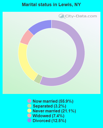
- Never married: 21.1%
- Now married: 55.9%
- Separated: 3.2%
- Widowed: 7.4%
- Divorced: 12.5%
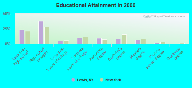
For population 25 years and over in Lewis:
- High school or higher: 76.5%
- Bachelor's degree or higher: 15.4%
- Graduate or professional degree: 7.9%
- Unemployed: 9.4%
- Mean travel time to work (commute): 20.9 minutes
| Here: | 11.8 |
| New York average: | 14.2 |
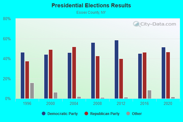
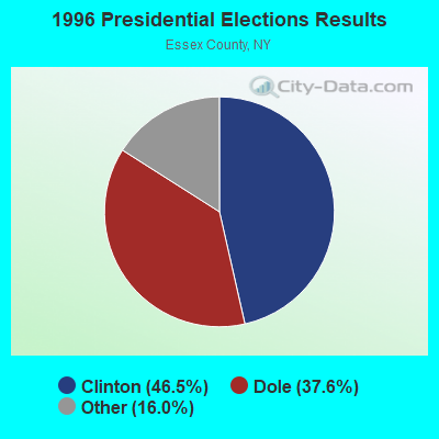
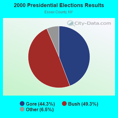
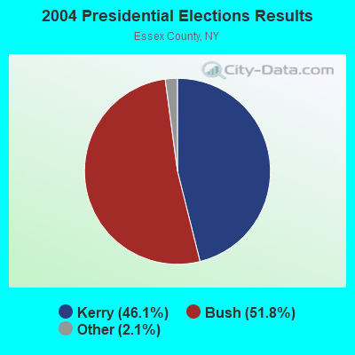
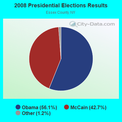
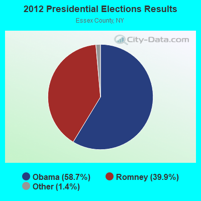
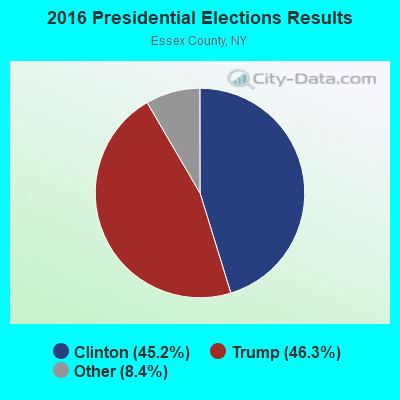
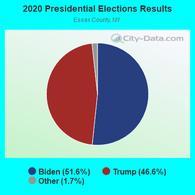
Graphs represent county-level data. Detailed 2008 Election Results
Religion statistics for Lewis, NY (based on Essex County data)
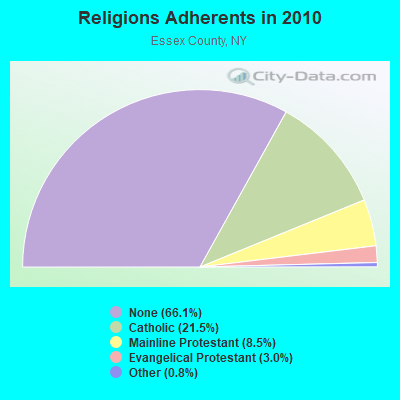
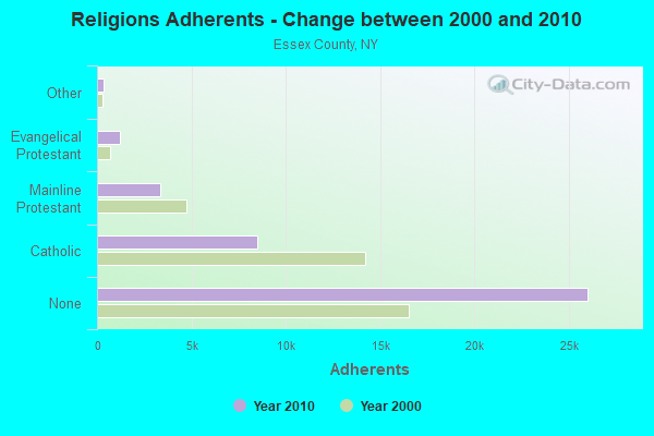
| Religion | Adherents | Congregations |
|---|---|---|
| Catholic | 8,467 | 17 |
| Mainline Protestant | 3,360 | 33 |
| Evangelical Protestant | 1,197 | 13 |
| Other | 328 | 4 |
| None | 26,018 | - |
Food Environment Statistics:
| Essex County: | 6.33 / 10,000 pop. |
| New York: | 4.13 / 10,000 pop. |
| Essex County: | 0.26 / 10,000 pop. |
| New York: | 0.06 / 10,000 pop. |
| Essex County: | 1.32 / 10,000 pop. |
| State: | 0.92 / 10,000 pop. |
| Essex County: | 6.07 / 10,000 pop. |
| New York: | 1.68 / 10,000 pop. |
| Essex County: | 18.99 / 10,000 pop. |
| New York: | 8.82 / 10,000 pop. |
| Essex County: | 7.8% |
| New York: | 8.2% |
| Essex County: | 22.6% |
| New York: | 23.8% |
| This county: | 16.0% |
| New York: | 15.6% |
Businesses in Lewis, NY
- H&R Block: 1
Strongest AM radio stations in Lewis:
- WCHP (760 AM; 35 kW; CHAMPLAIN, NY; Owner: CHAMPLAIN RADIO, INC.)
- WVMT (620 AM; 5 kW; BURLINGTON, VT; Owner: SISON BROADCASTING, INC.)
- WICY (1490 AM; 50 kW; MALONE, NY; Owner: CARTIER COMMUNICATIONS INC.)
- WEAV (960 AM; 5 kW; PLATTSBURGH, NY; Owner: CLEAR CHANNEL BROADCASTING LICENSES, INC.)
- WIRD (920 AM; 5 kW; LAKE PLACID, NY; Owner: RADIO LAKE PLACID INC)
- WTWK (1070 AM; daytime; 5 kW; PLATTSBURGH, NY; Owner: CHAMPLAIN COMMUNICATIONS CORPORATION)
- WVAA (1390 AM; 5 kW; BURLINGTON, VT; Owner: RADIO VERMONT, KDR, LLC)
- WGY (810 AM; 50 kW; SCHENECTADY, NY; Owner: CLEAR CHANNEL BROADCASTING LICENSES, INC.)
- WDEV (550 AM; 5 kW; WATERBURY, VT; Owner: RADIO VERMONT, INC.)
- WNNZ (640 AM; 50 kW; WESTFIELD, MA; Owner: CLEAR CHANNEL BROADCASTING LICENSES, INC.)
- WPTR (1540 AM; 50 kW; ALBANY, NY; Owner: KIMTRON, INC.)
- WRKO (680 AM; 50 kW; BOSTON, MA; Owner: ENTERCOM BOSTON LICENSE, LLC)
- WCRN (830 AM; 50 kW; WORCESTER, MA; Owner: CARTER BROADCASTING CORPORATION)
Strongest FM radio stations in Lewis:
- WDEV-FM (96.1 FM; WARREN, VT; Owner: RADIO VERMONT, INC.)
- WCVT (101.7 FM; STOWE, VT; Owner: RADIO VERMONT CLASSICS, L.L.C.)
- WIZN (106.7 FM; VERGENNES, VT; Owner: BURLINGTON BROADCASTERS, INC.)
- WXZO (96.7 FM; WILLSBORO, NY; Owner: CAPSTAR TX LIMITED PARTNERSHIP)
- WCEL (91.9 FM; PLATTSBURGH, NY; Owner: WAMC)
- WVPS (107.9 FM; BURLINGTON, VT; Owner: VERMONT PUBLIC RADIO)
- WEZF (92.9 FM; BURLINGTON, VT; Owner: CAPSTAR TX LIMITED PARTNERSHIP)
- WCLX (102.5 FM; WESTPORT, NY; Owner: WESTPORT BROADCASTING)
- WXLU (88.3 FM; PERU, NY; Owner: THE ST. LAWRENCE UNIVERSITY)
- WLKC (103.3 FM; WATERBURY, VT; Owner: RADIO BROADCASTING SERVICES, INC.)
- WNCS (104.7 FM; MONTPELIER, VT; Owner: MONTPELIER BROADCASTING, INC.)
- WYUL (94.7 FM; CHATEAUGAY, NY; Owner: CARTIER COMMUNICATIONS INC.)
- WEBK (105.3 FM; KILLINGTON, VT; Owner: 6 JOHNSON ROAD LICENSES, INC.)
- WJJR (98.1 FM; RUTLAND, VT; Owner: 6 JOHNSON ROAD LICENSES, INC.)
- WZRT (97.1 FM; RUTLAND, VT; Owner: CAPSTAR TX LIMITED PARTNERSHIP)
- WXLG (89.9 FM; NORTH CREEK, NY; Owner: THE ST. LAWRENCE UNIVERSITY)
- WCPV (101.3 FM; ESSEX, NY; Owner: CAPSTAR TX LIMITED PARTNERSHIP)
- WGLV (91.7 FM; WOODSTOCK, VT; Owner: CHRISTIAN MINISTRIES INC)
- WHDQ-FM1 (106.1 FM; RUTLAND, VT; Owner: GREAT NORTHERN RADIO, L.L.C.)
- WGLY-FM (91.5 FM; BOLTON, VT; Owner: CHRISTIAN MINISTRIES, INC.)
TV broadcast stations around Lewis:
- WPTZ (Channel 5; NORTH POLE, NY; Owner: HEARST-ARGYLE STATIONS, INC.)
- W19BR (Channel 19; MONKTON, VT; Owner: PLATTSBURGH PARTNERS)
- W16AL (Channel 16; BURLINGTON, VT; Owner: TRINITY BROADCASTING NETWORK)
- Lewis, New York
- Fatal accident count9
- Vehicles involved in fatal accidents10
- Fatal accidents involving drunk persons:3
- Fatalities10
- Persons involved in fatal accidents25
- Pedestrians involved in fatal accidents0
- New York average
- Fatal accident count7966
- Vehicles involved in fatal accidents11860
- Fatal accidents involving drunk persons1961
- Fatalities8613
- Persons involved in fatal accidents20197
- Pedestrians involved in fatal accidents2461
- National Bridge Inventory (NBI) Statistics
- 30Number of bridges
- 374ft / 114mTotal length
- $44,030,000Total costs
- 48,374Total average daily traffic
- 8,116Total average daily truck traffic
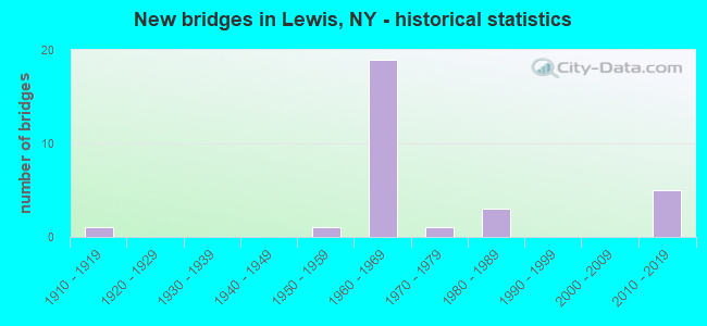
- New bridges - historical statistics
- 11910-1919
- 11950-1959
- 191960-1969
- 11970-1979
- 31980-1989
- 52010-2019
FCC Registered Antenna Towers:
7- Edward G Roach, Seventy Road (Lat: 44.303222 Lon: -73.613333), Type: 60.6, Overall height: 57.6 m, Registrant: None
- Edward G Roach, Seventy Road (Lat: 44.303222 Lon: -73.613333), Type: 60.6, Overall height: 57.6 m, Registrant: None
- Edward G Roach, Seventy Road (Lat: 44.303222 Lon: -73.613333), Type: 60.6, Overall height: 57.6 m, Registrant: None
- Leslie Lindeman, 9770 U.S. Route 9, Town Of Lewis, Essex County, Ny (Lat: 44.361167 Lon: -73.540556), Type: 25.9, Structure height: 36031 m, Overall height: 24.4 m, Registrant: Cityswitch Ii, LLC, Marshall.Hazlehurst@cityswitch.Com, Suite 320, Atlan-ta, Phone: (404) 518-2064
- Leslie Lindeman, 9770 U.S. Route 9, Town Of Lewis, Essex County, Ny (Lat: 44.361167 Lon: -73.540556), Type: 25.9, Structure height: 36031 m, Overall height: 24.4 m, Registrant: Cityswitch Ii, LLC, Marshall.Hazlehurst@cityswitch.Com, Suite 320, Atlan-ta, Phone: (404) 518-2064
- Leslie Lindeman, 9770 U.S. Route 9, Town Of Lewis, Essex County, Ny (Lat: 44.361167 Lon: -73.540556), Type: 25.9, Structure height: 36031 m, Overall height: 24.4 m, Registrant: Cityswitch Ii, LLC, Marshall.Hazlehurst@cityswitch.Com, Suite 320, Atlan-ta, Phone: (404) 518-2064
- Leslie Lindeman, 9770 U.S. Route 9, Town Of Lewis, Essex County, Ny (Lat: 44.361167 Lon: -73.540556), Type: 25.9, Structure height: 36031 m, Overall height: 24.4 m, Registrant: Cityswitch Ii, LLC, Marshall.Hazlehurst@cityswitch.Com, Suite 320, Atlan-ta, Phone: (404) 518-2064
FCC Registered Broadcast Land Mobile Towers:
6- Town Hall Route 9 (Lat: 44.315889 Lon: -73.546806), Call Sign: WXP652, Licensee ID: L00073157,
Assigned Frequencies: 151.100 MHz, Grant Date: 03/10/1998, Expiration Date: 05/09/2003, Cancellation Date: 08/10/2003, Registrant: Lewis, Town Of, Town Hall Route 9, Lewis, NY 12950
- Lat: 44.286583 Lon: -73.580000, Structure height: 0 m, Call Sign: WPXD694,
Assigned Frequencies: 451.587 MHz, Grant Date: 03/09/2023, Expiration Date: 03/12/2033, Certifier: Anthony J Glebus, Registrant: Town Of Lewis, 8574 Us Rt. 9, Lewis, NY 12950, Phone: (518) 873-6777, Fax: (518) 873-2372, Email:
- LEWIS, Nysp Station, 702 Stowersville Road (Lat: 44.282556 Lon: -73.536583), Type: Building, Structure height: 9 m, Overall height: 12 m, Call Sign: WQJX623,
Assigned Frequencies: 154.665 MHz, 154.695 MHz, 155.370 MHz, 155.565 MHz, 155.475 MHz, Grant Date: 11/08/2018, Expiration Date: 02/04/2029, Certifier: Charles L White Ii, Registrant: New York State Police, 1220 Washington Ave, Bldg 22, Albany, NY 12226-2252, Phone: (518) 457-9466, Fax: (518) 457-5676, Email:
- WELLS HILL, Summit Wells Hill (Lat: 44.303333 Lon: -73.613139), Type: Tower, Structure height: 15 m, Call Sign: WQPW776,
Assigned Frequencies: 458.287 MHz, Grant Date: 07/13/2022, Expiration Date: 09/04/2032, Certifier: Anthony J Lavigne, Registrant: Essex County Emergency Services, 702 Stowersville Rd, Lewis, NY 12950, Phone: (518) 873-3900, Fax: (518) 873-3963, Email:
- PAGING BASE, Wells Hill (Lat: 44.303389 Lon: -73.613167), Type: Gtower, Structure height: 15.2 m, Call Sign: WQXA353,
Assigned Frequencies: 46.4600 MHz, Grant Date: 01/12/2016, Expiration Date: 01/12/2026, Certifier: Donald Jaquish, Registrant: Wells Communication Service Inc, 221 N Greenbush Rd, Troy, NY 12180, Phone: (518) 283-2735, Fax: (518) 283-0901, Email:
- Lat: 44.331667 Lon: -73.552778, Call Sign: WRYM335,
Assigned Frequencies: 459.000 MHz, Grant Date: 08/28/2023, Expiration Date: 02/24/2024, Certifier: Alex Wulff, Registrant: Distributed Spectrum Inc., 147 W 25th St, Fl 4, New York, NY 10001, Phone: (917) 267-2514, Email:
FCC Registered Microwave Towers:
3- STATION, Wells Hill (Lat: 44.305306 Lon: -73.624000), Structure height: 4.6 m, Overall height: 12.8 m, Call Sign: WNTM286,
Assigned Frequencies: 2133.20 MHz, Grant Date: 07/31/2002, Expiration Date: 09/03/2012, Cancellation Date: 11/02/2011, Registrant: Essex County Emergency Services, 702 Stowersville Rd., Lewis, NY 12950, Phone: (518) 873-3900, Fax: (518) 873-3963, Email:
- LEWIS PSB, 720 Stowersville Road (Lat: 44.282167 Lon: -73.536306), Type: Bant, Structure height: 15.2 m, Overall height: 17.2 m, Call Sign: WQPJ325,
Assigned Frequencies: 6315.84 MHz, Grant Date: 04/27/2022, Expiration Date: 06/04/2032, Certifier: Donald S Janquish, Registrant: Essex County Emergency Services, 702 Stowersville Rd., Lewis, NY 12950, Phone: (518) 873-3900, Fax: (518) 873-3963, Email:
- WELLS, West Side Of Seventy Road (Lat: 44.303389 Lon: -73.613167), Type: Ltower, Structure height: 15.2 m, Overall height: 16.5 m, Call Sign: WQPJ326,
Assigned Frequencies: 6123.10 MHz, 6063.80 MHz, 5974.85 MHz, Grant Date: 04/27/2022, Expiration Date: 06/04/2032, Certifier: Donald S Janquish, Registrant: Essex County Emergency Services, 702 Stowersville Rd., Lewis, NY 12950, Phone: (518) 873-3900, Fax: (518) 873-3963, Email:
FCC Registered Paging Towers:
1- Hood Mountain, 2.6 Miles Ne Of (Lat: 44.292250 Lon: -73.517611), Overall height: 72.5 m, Call Sign: KGI787,
Assigned Frequencies: 931.237 MHz, Grant Date: 03/03/1999, Expiration Date: 07/01/2008, Cancellation Date: 03/18/2004, Certifier: Paul H Kuzia, Registrant: Wilkinson Barker Knauer, LLP, 2300 N Street, N.W., 7th Floor, Washington, DC 20037, Phone: (202) 783-4141, Fax: (202) 783-5851, Email:
FCC Registered Amateur Radio Licenses:
4- Call Sign: N2GIW, Previous Call Sign: KA2NMR, Licensee ID: L00766784, Grant Date: 11/12/2003, Expiration Date: 02/08/2014, Cancellation Date: 02/09/2016, Certifier: Gerald Rafferty, Registrant: Gerald Rafferty, 127 Moss Rd, Lewis, NY 12950
- Call Sign: N2JSG, Previous Call Sign: KB2GNQ, Licensee ID: L00205950, Grant Date: 01/21/2020, Expiration Date: 03/01/2030, Certifier: Dean M Bianco, Registrant: Dean M Bianco, 445 Moss Rd, Lewis, NY 12950
- Call Sign: N2ZBO, Licensee ID: L00865682, Grant Date: 09/24/2014, Expiration Date: 06/28/2024, Certifier: Tate M Connor, Registrant: Tate M Connor, 13 Deerhead Rd, Lewis, NY 12950
- Call Sign: KE2CSB, Licensee ID: L01247254, Grant Date: 02/22/2024, Expiration Date: 02/22/2034, Certifier: James M Weiskotten, Registrant: James M Weiskotten, 385 Wells Hill Rd, Lewis, NY 12950
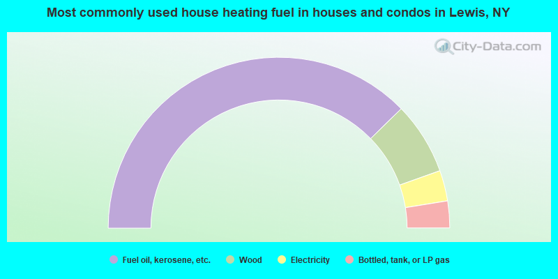
- 75.4%Fuel oil, kerosene, etc.
- 13.7%Wood
- 5.8%Electricity
- 5.1%Bottled, tank, or LP gas
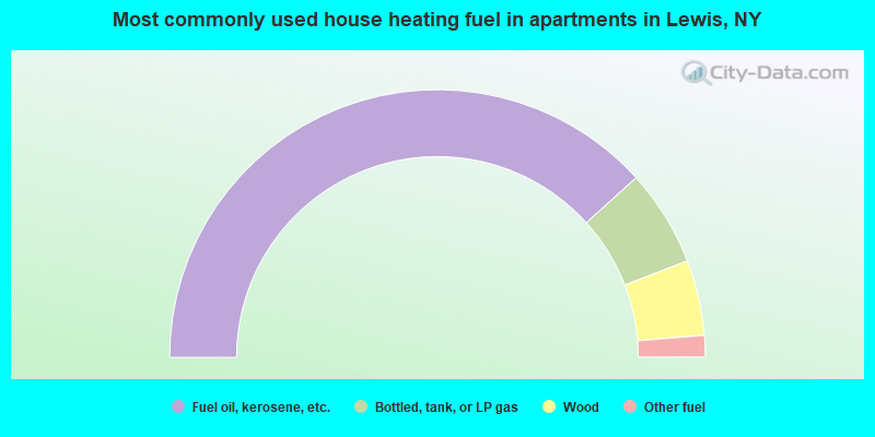
- 76.6%Fuel oil, kerosene, etc.
- 11.7%Bottled, tank, or LP gas
- 9.1%Wood
- 2.6%Other fuel
Lewis compared to New York state average:
- Median house value below state average.
- Black race population percentage significantly below state average.
- Hispanic race population percentage significantly below state average.
- Foreign-born population percentage significantly below state average.
- Renting percentage significantly below state average.
- Length of stay since moving in significantly above state average.
- Number of rooms per house significantly below state average.
- House age significantly below state average.
- Institutionalized population percentage significantly above state average.
- Number of college students below state average.
- Percentage of population with a bachelor's degree or higher below state average.