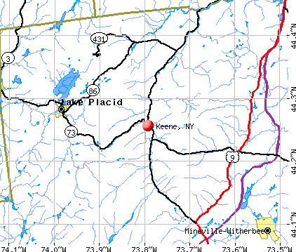
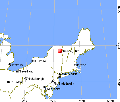
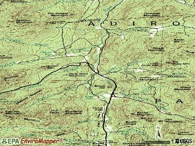
Keene, New York
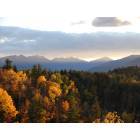
Keene: Atop East Hill
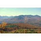
Keene: View from Little Crow Mountain
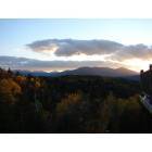
Keene: The Grand Range
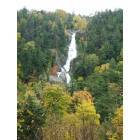
Keene: Waterfall in the Keene Valley, Keene NY
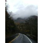
Keene: Mist on the Mountain, Keene Valley, NY
- add
your
Submit your own pictures of this town and show them to the world
- OSM Map
- General Map
- Google Map
- MSN Map
Population change since 2000: +4.0%
 |
| Males: 526 | |
| Females: 579 |
| Median resident age: | 51.1 years |
| New York median age: | 40.7 years |
Zip codes: 12943.
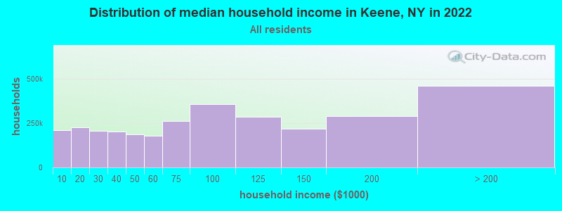
| Keene: | $65,419 |
| NY: | $79,557 |
Estimated per capita income in 2022: $36,758 (it was $17,037 in 2000)
Keene town income, earnings, and wages data
Estimated median house or condo value in 2022: $308,916 (it was $120,100 in 2000)
| Keene: | $308,916 |
| NY: | $400,400 |
Mean prices in 2022: all housing units: $276,108; detached houses: $284,996; townhouses or other attached units: $274,370; in 2-unit structures: $811,609; in 3-to-4-unit structures: $406,202; in 5-or-more-unit structures: $398,648; mobile homes: $92,731
Detailed information about poverty and poor residents in Keene, NY


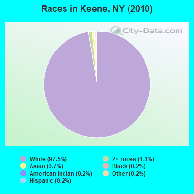
- 1,07797.5%White alone
- 121.1%Two or more races
- 80.7%Asian alone
- 20.2%Black alone
- 20.2%American Indian alone
- 20.2%Other race alone
- 20.2%Hispanic
Races in Keene detailed stats: ancestries, foreign born residents, place of birth
According to our research of New York and other state lists, there was 1 registered sex offender living in Keene, New York as of May 10, 2024.
The ratio of all residents to sex offenders in Keene is 1,105 to 1.
The ratio of registered sex offenders to all residents in this city is near the state average.
 Recent articles from our blog. Our writers, many of them Ph.D. graduates or candidates, create easy-to-read articles on a wide variety of topics.


Latest news from Keene, NY collected exclusively by city-data.com from local newspapers, TV, and radio stations
Ancestries: Irish (33.0%), English (28.3%), French (16.3%), German (14.3%), United States (6.2%), Italian (5.6%).
Current Local Time: EST time zone
Elevation: 834 feet
Land area: 156.0 square miles.
Population density: 7.1 people per square mile (very low).
9 residents are foreign born
| This town: | 0.8% |
| New York: | 20.4% |
| Keene town: | 1.3% ($1,529) |
| New York: | 1.9% ($2,847) |
Nearest city with pop. 50,000+: Schenectady, NY  (98.0 miles , pop. 61,821).
Nearest city with pop. 200,000+: Boston, MA (188.8 miles , pop. 589,141).
Nearest city with pop. 1,000,000+: Bronx, NY (233.1 miles , pop. 1,332,650).
Nearest cities:
), ), ), )Latitude: 44.22 N, Longitude: 73.79 W
Area code: 518

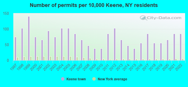
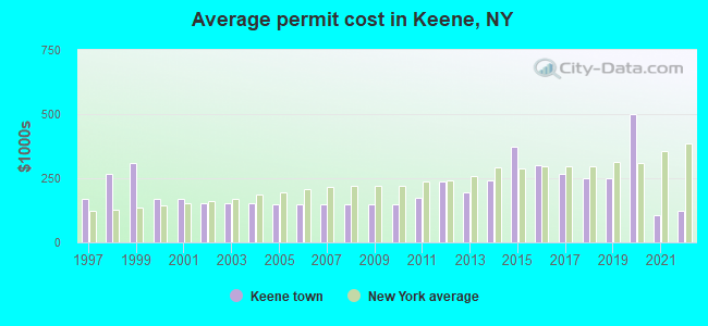
Single-family new house construction building permits:
- 2022: 9 buildings, average cost: $122,600
- 2021: 9 buildings, average cost: $105,600
- 2020: 7 buildings, average cost: $500,000
- 2019: 6 buildings, average cost: $249,800
- 2018: 6 buildings, average cost: $249,800
- 2017: 9 buildings, average cost: $267,800
- 2016: 6 buildings, average cost: $300,000
- 2015: 4 buildings, average cost: $375,000
- 2014: 5 buildings, average cost: $241,400
- 2013: 7 buildings, average cost: $193,300
- 2012: 11 buildings, average cost: $236,600
- 2011: 9 buildings, average cost: $172,800
- 2010: 4 buildings, average cost: $150,200
- 2009: 4 buildings, average cost: $150,200
- 2008: 5 buildings, average cost: $150,200
- 2007: 7 buildings, average cost: $150,200
- 2006: 9 buildings, average cost: $150,200
- 2005: 11 buildings, average cost: $150,200
- 2004: 11 buildings, average cost: $150,600
- 2003: 8 buildings, average cost: $150,600
- 2002: 10 buildings, average cost: $150,600
- 2001: 7 buildings, average cost: $168,300
- 2000: 8 buildings, average cost: $171,300
- 1999: 15 buildings, average cost: $308,100
- 1998: 11 buildings, average cost: $267,900
- 1997: 8 buildings, average cost: $170,000
| Here: | 4.7% |
| New York: | 4.4% |
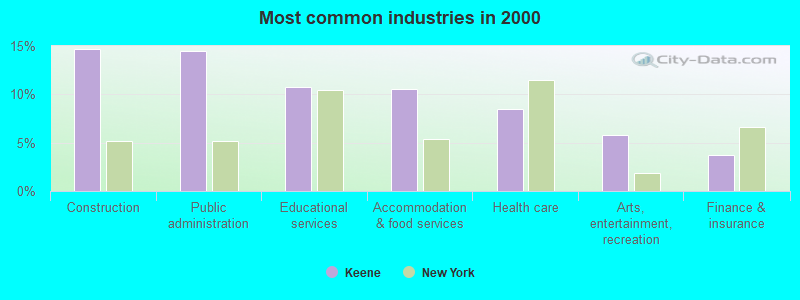
- Construction (14.6%)
- Public administration (14.4%)
- Educational services (10.7%)
- Accommodation & food services (10.5%)
- Health care (8.5%)
- Arts, entertainment, recreation (5.8%)
- Finance & insurance (3.7%)
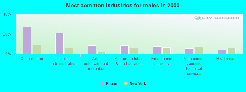
- Construction (27.1%)
- Public administration (21.1%)
- Arts, entertainment, recreation (8.5%)
- Accommodation & food services (8.5%)
- Educational services (7.3%)
- Professional, scientific, technical services (5.3%)
- Health care (3.6%)
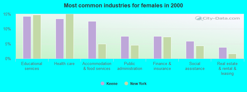
- Educational services (14.3%)
- Health care (13.4%)
- Accommodation & food services (12.6%)
- Public administration (7.6%)
- Finance & insurance (7.6%)
- Social assistance (5.9%)
- Real estate & rental & leasing (3.8%)
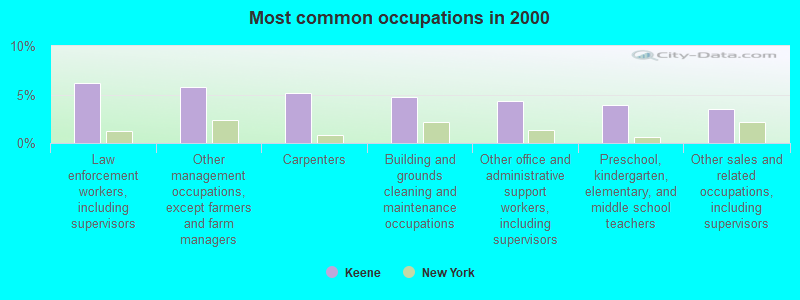
- Law enforcement workers, including supervisors (6.2%)
- Other management occupations, except farmers and farm managers (5.8%)
- Carpenters (5.2%)
- Building and grounds cleaning and maintenance occupations (4.7%)
- Other office and administrative support workers, including supervisors (4.3%)
- Preschool, kindergarten, elementary, and middle school teachers (3.9%)
- Other sales and related occupations, including supervisors (3.5%)
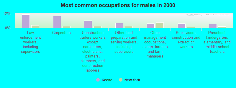
- Law enforcement workers, including supervisors (11.3%)
- Carpenters (10.1%)
- Construction traders workers except carpenters, electricians, painters, plumbers, and construction laborers (6.1%)
- Other food preparation and serving workers, including supervisors (4.0%)
- Other management occupations, except farmers and farm managers (3.6%)
- Supervisors, construction and extraction workers (3.6%)
- Preschool, kindergarten, elementary, and middle school teachers (3.2%)
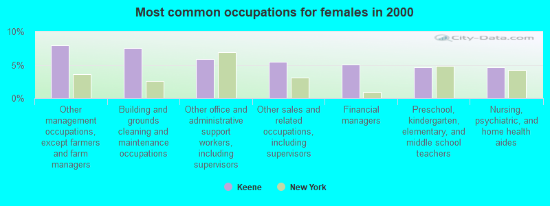
- Other management occupations, except farmers and farm managers (8.0%)
- Building and grounds cleaning and maintenance occupations (7.6%)
- Other office and administrative support workers, including supervisors (5.9%)
- Other sales and related occupations, including supervisors (5.5%)
- Financial managers (5.0%)
- Preschool, kindergarten, elementary, and middle school teachers (4.6%)
- Nursing, psychiatric, and home health aides (4.6%)
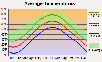
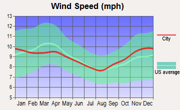
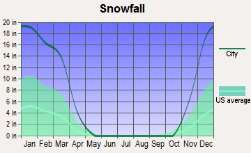
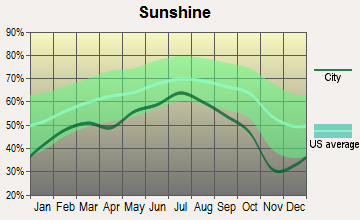
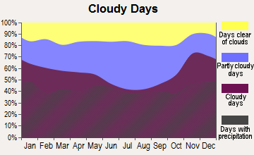
Average climate in Keene, New York
Based on data reported by over 4,000 weather stations
(lower is better)
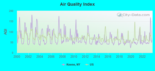
Air Quality Index (AQI) level in 2023 was 77.4. This is about average.
| City: | 77.4 |
| U.S.: | 72.6 |
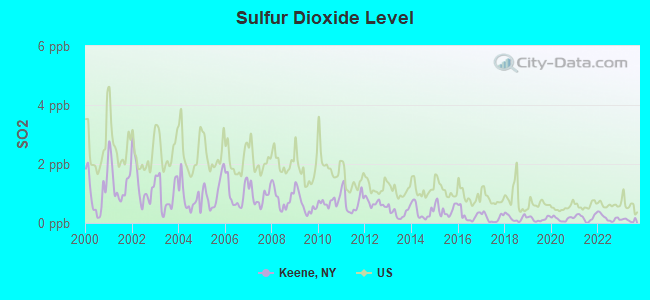
Sulfur Dioxide (SO2) [ppb] level in 2023 was 0.100. This is significantly better than average. Closest monitor was 12.7 miles away from the city center.
| City: | 0.100 |
| U.S.: | 1.515 |
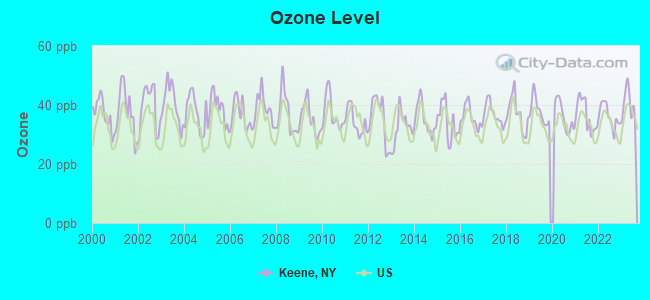
Ozone [ppb] level in 2023 was 39.9. This is about average. Closest monitor was 11.8 miles away from the city center.
| City: | 39.9 |
| U.S.: | 33.3 |
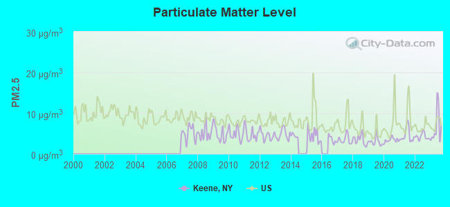
Particulate Matter (PM2.5) [µg/m3] level in 2023 was 6.51. This is better than average. Closest monitor was 12.7 miles away from the city center.
| City: | 6.51 |
| U.S.: | 8.11 |
Earthquake activity:
Keene-area historical earthquake activity is significantly above New York state average. It is 70% smaller than the overall U.S. average.On 4/20/2002 at 10:50:47, a magnitude 5.3 (5.3 ML, Depth: 3.0 mi, Class: Moderate, Intensity: VI - VII) earthquake occurred 20.9 miles away from Keene center
On 10/7/1983 at 10:18:46, a magnitude 5.3 (5.1 MB, 5.3 LG, 5.1 ML) earthquake occurred 33.0 miles away from Keene center
On 4/20/2002 at 10:50:47, a magnitude 5.2 (5.2 MB, 4.2 MS, 5.2 MW, 5.0 MW) earthquake occurred 19.0 miles away from Keene center
On 1/19/1982 at 00:14:42, a magnitude 4.7 (4.5 MB, 4.7 MD, 4.5 LG, Class: Light, Intensity: IV - V) earthquake occurred 119.9 miles away from Keene center
On 10/16/2012 at 23:12:25, a magnitude 4.7 (4.7 ML, Depth: 10.0 mi) earthquake occurred 161.8 miles away from the city center
On 4/20/2000 at 08:46:55, a magnitude 3.8 (3.8 ML, Depth: 3.1 mi, Class: Light, Intensity: II - III) earthquake occurred 29.8 miles away from the city center
Magnitude types: regional Lg-wave magnitude (LG), body-wave magnitude (MB), duration magnitude (MD), local magnitude (ML), surface-wave magnitude (MS), moment magnitude (MW)
Natural disasters:
The number of natural disasters in Essex County (19) is greater than the US average (15).Major Disasters (Presidential) Declared: 12
Emergencies Declared: 5
Causes of natural disasters: Storms: 8, Floods: 7, Hurricanes: 4, Winds: 2, Winter Storms: 2, Blizzard: 1, Earthquake: 1, Power Outage: 1, Snowstorm: 1, Tornado: 1, Other: 2 (Note: some incidents may be assigned to more than one category).
Airports located in Keene:
- Marcy Field Airport (1I1) (Runways: 1, Itinerant Ops: 20, Local Ops: 100, Military Ops: 15)
Amtrak stations near Keene:
- 11 miles: LAKE PLACID (MAIN ST.) - Seasonal Bus Station . Services: fully wheelchair accessible, free short-term parking, call for car rental service, call for taxi service.
- 17 miles: WESTPORT (HWY. 9 N. & D&H RAILROAD TRACKS) . Services: enclosed waiting area, public restrooms, public payphones, free short-term parking, free long-term parking.
Colleges/universities with over 2000 students nearest to Keene:
- Middlebury College (about 34 miles; Middlebury, VT; Full-time enrollment: 3,077)
- Champlain College (about 34 miles; Burlington, VT; FT enrollment: 2,623)
- University of Vermont (about 35 miles; Burlington, VT; FT enrollment: 11,566)
- Community College of Vermont (about 36 miles; Winooski, VT; FT enrollment: 3,394)
- Saint Michael's College (about 37 miles; Colchester, VT; FT enrollment: 2,336)
- SUNY College at Plattsburgh (about 37 miles; Plattsburgh, NY; FT enrollment: 5,934)
- Castleton State College (about 52 miles; Castleton, VT; FT enrollment: 2,079)
Public high school in Keene:
- KEENE CENTRAL SCHOOL (Students: 171, Location: 33 MARKET ST, Grades: KG-12)
Points of interest:
Notable locations in Keene: The Carry (A), Four Corners (B), Ausable Club Golf Course (C), Keene Public Library (D), Keene Valley Library (E), Keene Valley Hose and Ladder Company 1 (F). Display/hide their locations on the map
Churches in Keene include: Keene Valley Congregational Church (A), Saint Brendan's Catholic Church (B). Display/hide their locations on the map
Cemeteries: Shaw Cemetery (1), Ingalls Cemetery (2), Estes Cemetery (3), Norton Cemetery (4), Holt Cemetery (5). Display/hide their locations on the map
Lakes and reservoirs: Lillypad Pond (A), Little Meadows (B), Lower Asuable Lake (C), Lower Cascade Lake (D), Moss Pond (E), Rhododendron Pond (F), Lake Tear of the Clouds (G), Twin Pond (H). Display/hide their locations on the map
Streams, rivers, and creeks: Gulf Brook (A), Gravestone Brook (B), Gill Brook (C), Wolfjaw Brook (D), Slide Brook (E), Slide Mountain Brook (F), Flume Brook (G), Basin Brook (H), Teakettle Brook (I). Display/hide their locations on the map
Hotel: Bark Eater Inn (Alstead Hill Ln) (1). Display/hide its approximate location on the map
| This town: | 2.1 people |
| New York: | 2.6 people |
| This town: | 58.9% |
| Whole state: | 63.5% |
| This town: | 5.9% |
| Whole state: | 6.8% |
Likely homosexual households (counted as self-reported same-sex unmarried-partner households)
- Lesbian couples: 0.8% of all households
- Gay men: 0.8% of all households
| This town: | 4.7% |
| Whole state: | 14.6% |
| This town: | 2.0% |
| Whole state: | 7.4% |
Banks with branches in Keene (2011 data):
- Champlain National Bank: Keene Branch at 10849 Nys Route 9n, branch established on 1987/11/09. Info updated 2008/12/22: Bank assets: $224.9 mil, Deposits: $191.5 mil, headquarters in Elizabethtown, NY, positive income, Commercial Lending Specialization, 9 total offices, Holding Company: Champlain Bank Corporation
For population 15 years and over in Keene:
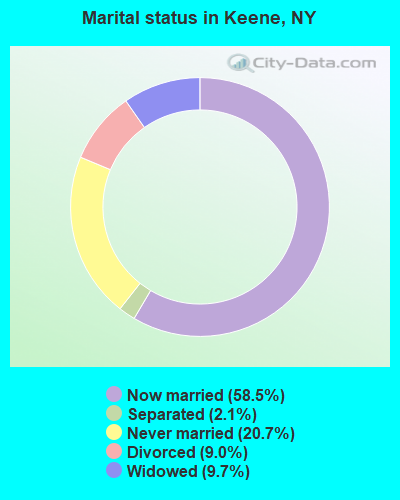
- Never married: 20.7%
- Now married: 58.5%
- Separated: 2.1%
- Widowed: 9.7%
- Divorced: 9.0%
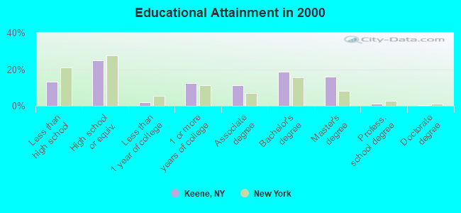
For population 25 years and over in Keene:
- High school or higher: 87.0%
- Bachelor's degree or higher: 36.4%
- Graduate or professional degree: 17.6%
- Unemployed: 3.4%
- Mean travel time to work (commute): 18.6 minutes
| Here: | 10.4 |
| New York average: | 14.2 |
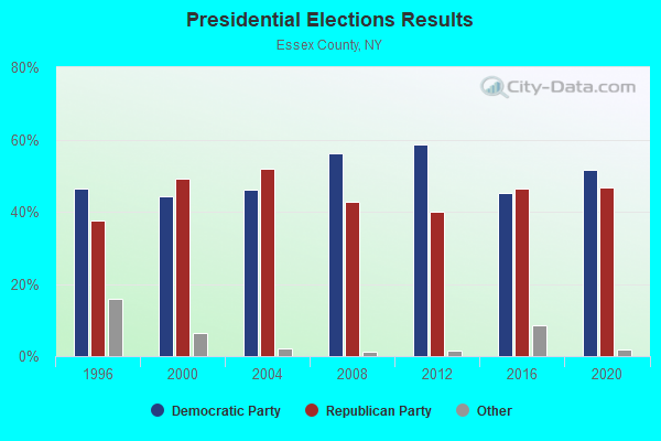
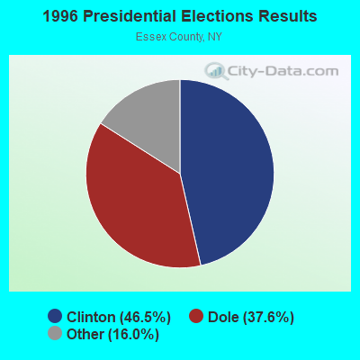
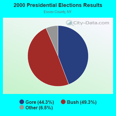
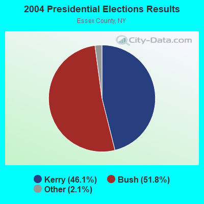
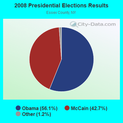
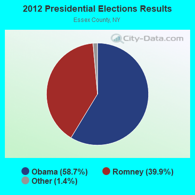
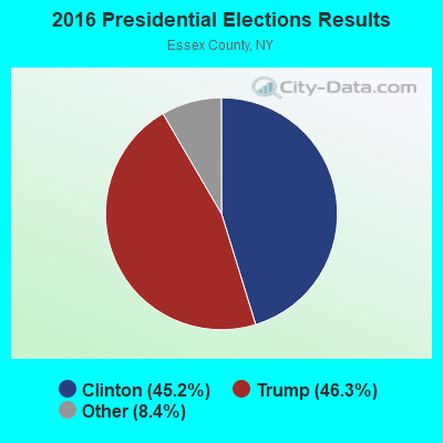
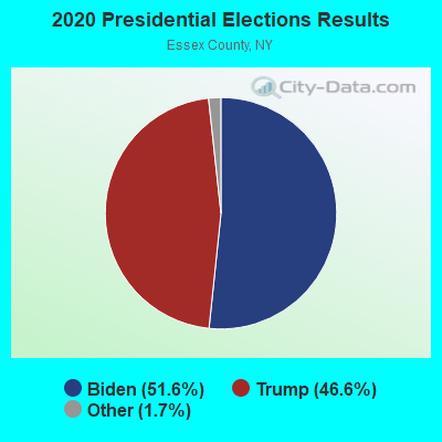
Graphs represent county-level data. Detailed 2008 Election Results
Religion statistics for Keene, NY (based on Essex County data)
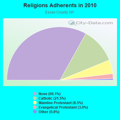
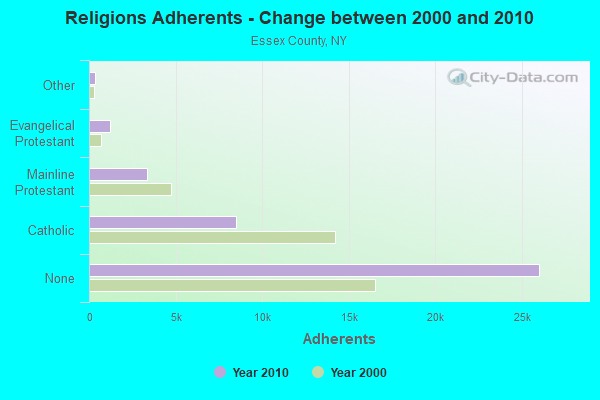
| Religion | Adherents | Congregations |
|---|---|---|
| Catholic | 8,467 | 17 |
| Mainline Protestant | 3,360 | 33 |
| Evangelical Protestant | 1,197 | 13 |
| Other | 328 | 4 |
| None | 26,018 | - |
Food Environment Statistics:
| Essex County: | 6.33 / 10,000 pop. |
| State: | 4.13 / 10,000 pop. |
| Essex County: | 0.26 / 10,000 pop. |
| New York: | 0.06 / 10,000 pop. |
| Here: | 1.32 / 10,000 pop. |
| New York: | 0.92 / 10,000 pop. |
| Essex County: | 6.07 / 10,000 pop. |
| New York: | 1.68 / 10,000 pop. |
| Essex County: | 18.99 / 10,000 pop. |
| New York: | 8.82 / 10,000 pop. |
| Essex County: | 7.8% |
| New York: | 8.2% |
| This county: | 22.6% |
| New York: | 23.8% |
| Essex County: | 16.0% |
| State: | 15.6% |
Strongest AM radio stations in Keene:
- WIRD (920 AM; 5 kW; LAKE PLACID, NY; Owner: RADIO LAKE PLACID INC)
- WCHP (760 AM; 35 kW; CHAMPLAIN, NY; Owner: CHAMPLAIN RADIO, INC.)
- WICY (1490 AM; 50 kW; MALONE, NY; Owner: CARTIER COMMUNICATIONS INC.)
- WGY (810 AM; 50 kW; SCHENECTADY, NY; Owner: CLEAR CHANNEL BROADCASTING LICENSES, INC.)
- WVMT (620 AM; 5 kW; BURLINGTON, VT; Owner: SISON BROADCASTING, INC.)
- WEAV (960 AM; 5 kW; PLATTSBURGH, NY; Owner: CLEAR CHANNEL BROADCASTING LICENSES, INC.)
- WTWK (1070 AM; daytime; 5 kW; PLATTSBURGH, NY; Owner: CHAMPLAIN COMMUNICATIONS CORPORATION)
- WNNZ (640 AM; 50 kW; WESTFIELD, MA; Owner: CLEAR CHANNEL BROADCASTING LICENSES, INC.)
- WPTR (1540 AM; 50 kW; ALBANY, NY; Owner: KIMTRON, INC.)
- WVAA (1390 AM; 5 kW; BURLINGTON, VT; Owner: RADIO VERMONT, KDR, LLC)
- WDEV (550 AM; 5 kW; WATERBURY, VT; Owner: RADIO VERMONT, INC.)
- WNBZ (1240 AM; 1 kW; SARANAC LAKE, NY; Owner: SARANAC LAKE RADIO, L.L.C.)
- WRKO (680 AM; 50 kW; BOSTON, MA; Owner: ENTERCOM BOSTON LICENSE, LLC)
Strongest FM radio stations in Keene:
- WCEL (91.9 FM; PLATTSBURGH, NY; Owner: WAMC)
- WDEV-FM (96.1 FM; WARREN, VT; Owner: RADIO VERMONT, INC.)
- WXLU (88.3 FM; PERU, NY; Owner: THE ST. LAWRENCE UNIVERSITY)
- WXLG (89.9 FM; NORTH CREEK, NY; Owner: THE ST. LAWRENCE UNIVERSITY)
- WCVT (101.7 FM; STOWE, VT; Owner: RADIO VERMONT CLASSICS, L.L.C.)
- WVPS (107.9 FM; BURLINGTON, VT; Owner: VERMONT PUBLIC RADIO)
- WEZF (92.9 FM; BURLINGTON, VT; Owner: CAPSTAR TX LIMITED PARTNERSHIP)
- WXLH (91.3 FM; BLUE MOUNTAIN LAKE, NY; Owner: THE ST. LAWRENCE UNIVERSITY)
- WYUL (94.7 FM; CHATEAUGAY, NY; Owner: CARTIER COMMUNICATIONS INC.)
- WRGR (102.3 FM; TUPPER LAKE, NY; Owner: RADIO LAKE PLACID, INC.)
- WLKC (103.3 FM; WATERBURY, VT; Owner: RADIO BROADCASTING SERVICES, INC.)
- WNCS (104.7 FM; MONTPELIER, VT; Owner: MONTPELIER BROADCASTING, INC.)
- WEBK (105.3 FM; KILLINGTON, VT; Owner: 6 JOHNSON ROAD LICENSES, INC.)
- WJJR (98.1 FM; RUTLAND, VT; Owner: 6 JOHNSON ROAD LICENSES, INC.)
- WZRT (97.1 FM; RUTLAND, VT; Owner: CAPSTAR TX LIMITED PARTNERSHIP)
- WIZN (106.7 FM; VERGENNES, VT; Owner: BURLINGTON BROADCASTERS, INC.)
- WXZO (96.7 FM; WILLSBORO, NY; Owner: CAPSTAR TX LIMITED PARTNERSHIP)
- WGLV (91.7 FM; WOODSTOCK, VT; Owner: CHRISTIAN MINISTRIES INC)
- WHDQ-FM1 (106.1 FM; RUTLAND, VT; Owner: GREAT NORTHERN RADIO, L.L.C.)
- W209AZ (89.7 FM; KEENE, NY; Owner: THE ST. LAWRENCE UNIVERSITY)
TV broadcast stations around Keene:
- WPTZ (Channel 5; NORTH POLE, NY; Owner: HEARST-ARGYLE STATIONS, INC.)
- Keene, New York
- Fatal accident count8
- Vehicles involved in fatal accidents11
- Fatal accidents involving drunk persons:2
- Fatalities8
- Persons involved in fatal accidents17
- Pedestrians involved in fatal accidents0
- New York average
- Fatal accident count7235
- Vehicles involved in fatal accidents10868
- Fatal accidents involving drunk persons1728
- Fatalities7775
- Persons involved in fatal accidents17788
- Pedestrians involved in fatal accidents2339
- National Bridge Inventory (NBI) Statistics
- 37Number of bridges
- 223ft / 67.7mTotal length
- $36,100,000Total costs
- 55,107Total average daily traffic
- 3,002Total average daily truck traffic
- 59,948Total future (year 2034) average daily traffic
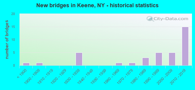
- New bridges - historical statistics
- 1Before 1900
- 11900-1909
- 51930-1939
- 11960-1969
- 11970-1979
- 31980-1989
- 51990-1999
- 52000-2009
- 152010-2019
FCC Registered Antenna Towers:
5- Tom Weber, 1786 Nys Route 73 (Lat: 44.189861 Lon: -73.785056), Type: 39.3, Overall height: 38.1 m, Registrant: New York Rsa 2 Cellular Partnership, Network.Regulatory@verizonwireless.Com, , Alpha-retta, Phone: (770) 797-1070
- Ljubica Petrich, 1786 Nys Route 73 (Lat: 44.189861 Lon: -73.785056), Type: 39.3, Overall height: 38.1 m, Registrant: New York Rsa 2 Cellular Partnership, Network.Regulatory@verizonwireless.Com, , Alpha-retta, Phone: (770) 797-1070
- Jerri L Janjua, 1786 Nys Route 73 (Lat: 44.189861 Lon: -73.785056), Type: 39.3, Overall height: 38.1 m, Registrant: New York Rsa 2 Cellular Partnership, Network.Regulatory@verizonwireless.Com, , Alpha-retta, Phone: (770) 797-1070
- Regulatory Manager, 1786 Nys Route 73 (Lat: 44.189861 Lon: -73.785056), Type: 39.3, Structure height: 36031 m, Overall height: 38.1 m, Registrant: Verizon Wireless, Network.Regulatory@verizonwireless.Com, , Alpha-retta, Phone: (770) 797-1070
- Gina Cacciatore, 1786 Nys Route 73 (Lat: 44.189861 Lon: -73.785056), Type: 39.3, Structure height: 36031 m, Overall height: 38.1 m, Licensee ID: D, Registrant: New York Rsa 2 Cellular Partnership, Networkregulatory@verizonwireless.Com, Np2ne Network Engineering, Alpha-retta, Phone: (770) 797-1070
FCC Registered Amateur Radio Licenses:
11 (See the full list of FCC Registered Amateur Radio Licenses in Keene)| Most common first names in Keene, NY among deceased individuals | ||
| Name | Count | Lived (average) |
|---|---|---|
| John | 7 | 76.4 years |
| Mary | 5 | 78.6 years |
| Robert | 5 | 71.8 years |
| Harry | 3 | 80.3 years |
| Anna | 3 | 76.3 years |
| Charles | 3 | 77.7 years |
| Elizabeth | 3 | 86.0 years |
| Frances | 3 | 86.6 years |
| Howard | 3 | 77.3 years |
| Walter | 3 | 82.0 years |
| Most common last names in Keene, NY among deceased individuals | ||
| Last name | Count | Lived (average) |
|---|---|---|
| Smith | 8 | 78.0 years |
| Wells | 7 | 81.8 years |
| Cram | 6 | 82.2 years |
| Reed | 6 | 83.6 years |
| Lashway | 5 | 80.2 years |
| Lawrence | 5 | 80.6 years |
| Carey | 4 | 70.0 years |
| Estes | 4 | 74.2 years |
| Evans | 3 | 69.3 years |
| Hale | 3 | 81.3 years |
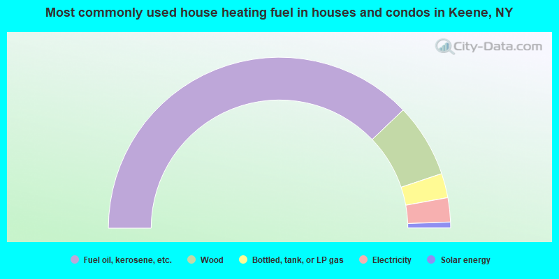
- 75.7%Fuel oil, kerosene, etc.
- 14.0%Wood
- 4.6%Bottled, tank, or LP gas
- 4.6%Electricity
- 1.1%Solar energy
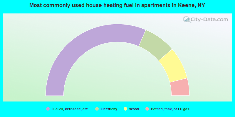
- 62.9%Fuel oil, kerosene, etc.
- 14.6%Electricity
- 14.6%Wood
- 7.9%Bottled, tank, or LP gas
Keene compared to New York state average:
- Unemployed percentage significantly below state average.
- Black race population percentage significantly below state average.
- Hispanic race population percentage significantly below state average.
- Median age significantly above state average.
- Foreign-born population percentage significantly below state average.
- Renting percentage significantly below state average.
- Length of stay since moving in significantly above state average.
- Number of rooms per house significantly below state average.
- House age significantly below state average.
Keene on our top lists:
- #2 on the list of "Top 101 cities with the largest percentage of people in homes for the physically handicapped (population 1,000+)"
- #15 on the list of "Top 101 counties with the lowest Particulate Matter (PM2.5) Annual air pollution readings in 2012 (µg/m3)"

|
Total of 8 patent applications in 2008-2024.