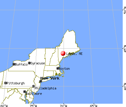
Leeds, Maine
Submit your own pictures of this town and show them to the world
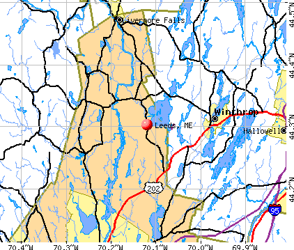
- OSM Map
- General Map
- Google Map
- MSN Map
Population change since 2000: +16.2%
 |
| Males: 1,193 | |
| Females: 1,133 |
| Median resident age: | 41.3 years |
| Maine median age: | 43.0 years |
Zip codes: 04263.
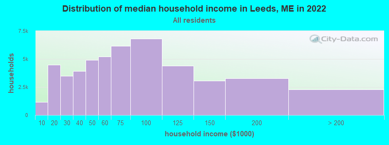
| Leeds: | $67,337 |
| ME: | $69,543 |
Estimated per capita income in 2022: $27,411 (it was $15,602 in 2000)
Leeds town income, earnings, and wages data
Estimated median house or condo value in 2022: $255,738 (it was $89,400 in 2000)
| Leeds: | $255,738 |
| ME: | $290,600 |
Mean prices in 2022: all housing units: $249,170; detached houses: $267,476; townhouses or other attached units: $202,361; in 2-unit structures: $200,400; in 3-to-4-unit structures: $182,257; in 5-or-more-unit structures: $238,166; mobile homes: $73,615
Detailed information about poverty and poor residents in Leeds, ME
Compare current foreclosures near Leeds, ME:
| Photo | Address | Area | Beds / Baths | Price | Details |
|---|---|---|---|---|---|

|
#1
Dr Mann Rd
Augusta, ME 04330
|
1,320 sq. feet
|
2 baths 2 beds |
$315,000
|
show details |

|
#2
Nottingham Rd
Auburn, ME 04210
|
1,692 sq. feet
|
2 baths 2 beds |
show details | |

|
#3
Jillson Rd
Greene, ME 04236
|
1,356 sq. feet
|
1 baths 4 beds |
show details | |

|
#4
Western Promenade
Auburn, ME 04210
|
2,908 sq. feet
|
3 baths 5 beds |
show details | |

|
#5
Stevens Mill Rd
Auburn, ME 04210
|
1,547 sq. feet
|
2 baths 4 beds |
show details | |

|
#6
Moose Hill Rd
Livermore Falls, ME 04254
|
1,193 sq. feet
|
1 baths 3 beds |
show details | |

|
#7
Anita Ave
Auburn, ME 04210
|
2,016 sq. feet
|
1 baths 3 beds |
show details | |

|
#8
Cressey Rd
Monmouth, ME 04259
|
2,503 sq. feet
|
2 baths 4 beds |
show details | |

|
#9
Main St
Lewiston, ME 04240
|
- sq. feet
|
1 baths 3 beds |
show details | |

|
#10
Minot Ave
Auburn, ME 04210
|
1,444 sq. feet
|
1 baths 3 beds |
show details |
| Photo | Address | Area | Beds / Baths | Price | Details |
|---|---|---|---|---|---|

|
#11
Marsh Rd
Sabattus, ME 04280
|
1,932 sq. feet
|
2 baths - beds |
show details | |

|
#12
Webster Corner Rd
Sabattus, ME 04280
|
1,619 sq. feet
|
1 baths - beds |
show details | |

|
#13
Xivray St
Auburn, ME 04210
|
2,632 sq. feet
|
1 baths - beds |
show details | |

|
#14
Row House Ln
Hallowell, ME 04347
|
- sq. feet
|
- baths - beds |
show details | |

|
#15
Meadow Rd Apt 204
Augusta, ME 04330
|
- sq. feet
|
- baths - beds |
show details | |

|
#16
Sabattus Creek Dr
Lisbon, ME 04250
|
- sq. feet
|
- baths - beds |
show details | |

|
#17
Pleasant St # 2
Augusta, ME 04330
|
- sq. feet
|
- baths - beds |
show details | |

|
#18
Back St
Hebron, ME 04238
|
1,340 sq. feet
|
- baths - beds |
show details | |

|
#19
Riverside Dr # 650
Auburn, ME 04210
|
- sq. feet
|
- baths - beds |
show details | |

|
#20
Belmont Ct, Unit 8
Auburn, ME 04210
|
- sq. feet
|
- baths - beds |
show details |
| Photo | Address | Area | Beds / Baths | Price | Details |
|---|---|---|---|---|---|

|
#21
Prescott Rd
Manchester, ME 04351
|
1,440 sq. feet
|
- baths - beds |
show details | |

|
#22
Bartlett St
Lewiston, ME 04240
|
- sq. feet
|
- baths - beds |
show details | |

|
#23
Spring St Apt 2
Lewiston, ME 04240
|
- sq. feet
|
- baths - beds |
show details | |

|
#24
School St
Lewiston, ME 04240
|
- sq. feet
|
- baths - beds |
show details | |

|
#25
Bowman St
Farmingdale, ME 04344
|
- sq. feet
|
- baths - beds |
show details | |

|
#26
Cornerstone Dr
Bowdoin, ME 04287
|
- sq. feet
|
- baths - beds |
show details | |

|
#27
County Rd
Turner, ME 04282
|
- sq. feet
|
- baths - beds |
show details | |

|
#28
Bowman St
Farmingdale, ME 04344
|
- sq. feet
|
- baths - beds |
show details | |

|
#29
Pond Rd
Sabattus, ME 04280
|
- sq. feet
|
- baths - beds |
show details | |

|
#30
High St
Buckfield, ME 04220
|
- sq. feet
|
- baths - beds |
show details |
| Photo | Address | Area | Beds / Baths | Price | Details |
|---|---|---|---|---|---|

|
#31
Meadow Brook Dr
Belgrade, ME 04917
|
- sq. feet
|
- baths - beds |
show details | |

|
#32
River Common Rd
Sabattus, ME 04280
|
- sq. feet
|
- baths - beds |
show details | |

|
#33
Brault St
Lewiston, ME 04240
|
- sq. feet
|
- baths - beds |
show details | |

|
#34
Autumn Ln
Lewiston, ME 04240
|
- sq. feet
|
- baths - beds |
show details | |

|
#35
River Rd
Lewiston, ME 04240
|
- sq. feet
|
- baths - beds |
show details | |

|
#36
Magnum Dr
Turner, ME 04282
|
- sq. feet
|
- baths - beds |
show details | |

|
#37
Reservoir Rd
South Paris, ME 04281
|
- sq. feet
|
- baths - beds |
show details | |

|
Check over 1 million property listings on Foreclosure.com!
|
browse all offers | |||

- 2,23896.2%White alone
- 401.7%Hispanic
- 261.1%Two or more races
- 120.5%American Indian alone
- 60.3%Black alone
- 40.2%Asian alone
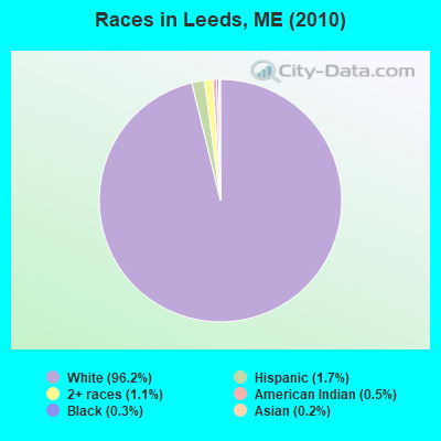
Races in Leeds detailed stats: ancestries, foreign born residents, place of birth
According to our research of Maine and other state lists, there were 5 registered sex offenders living in Leeds, Maine as of May 08, 2024.
The ratio of all residents to sex offenders in Leeds is 465 to 1.
The ratio of registered sex offenders to all residents in this city is near the state average.
 Recent articles from our blog. Our writers, many of them Ph.D. graduates or candidates, create easy-to-read articles on a wide variety of topics.

 | Small houses (not tiny; 600-800 sq ft) (30 replies) |
| Thinking about moving to Maine (447 replies) |
| Possible move to Androscoggin County (5 replies) |
| land, septic, and well drilling (5 replies) |
| Lets just get rid of smoking (63 replies) |
| Maine-grown wheat? (13 replies) |
Latest news from Leeds, ME collected exclusively by city-data.com from local newspapers, TV, and radio stations
Ancestries: English (19.1%), French (15.8%), United States (13.6%), Irish (12.5%), French Canadian (10.1%), German (4.7%).
Current Local Time: EST time zone
Incorporated on 02/16/1801
Elevation: 302 feet
Land area: 40.3 square miles.
Population density: 58 people per square mile (very low).
20 residents are foreign born
| This town: | 1.0% |
| Maine: | 2.9% |
| Leeds town: | 1.4% ($1,219) |
| Maine: | 1.5% ($1,417) |
Nearest city with pop. 50,000+: Portland, ME  (43.5 miles , pop. 64,249).
Nearest city with pop. 200,000+: Boston, MA (144.3 miles , pop. 589,141).
Nearest city with pop. 1,000,000+: Bronx, NY (305.2 miles , pop. 1,332,650).
Nearest cities:
), ), ), )Latitude: 44.28 N, Longitude: 70.11 W
Area code: 207

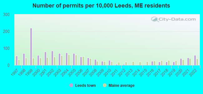
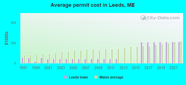
Single-family new house construction building permits:
- 2022: 12 buildings, average cost: $265,300
- 2021: 9 buildings, average cost: $265,300
- 2020: 8 buildings, average cost: $265,300
- 2019: 4 buildings, average cost: $261,800
- 2018: 4 buildings, average cost: $261,800
- 2017: 4 buildings, average cost: $261,800
- 2016: 5 buildings, average cost: $261,800
- 2012: 1 building, cost: $55,100
- 2011: 1 building, cost: $55,100
- 2010: 6 buildings, average cost: $55,100
- 2009: 5 buildings, average cost: $55,100
- 2008: 7 buildings, average cost: $55,100
- 2007: 9 buildings, average cost: $55,100
- 2006: 10 buildings, average cost: $55,100
- 2005: 14 buildings, average cost: $55,100
- 2004: 15 buildings, average cost: $55,100
- 2003: 14 buildings, average cost: $55,100
- 2002: 17 buildings, average cost: $55,500
- 2001: 16 buildings, average cost: $52,600
- 2000: 12 buildings, average cost: $68,700
- 1999: 44 buildings, average cost: $25,900
- 1998: 14 buildings, average cost: $66,900
- 1997: 11 buildings, average cost: $71,800
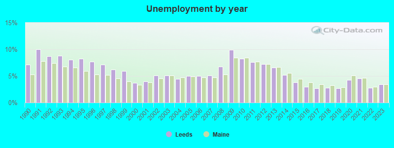
| Here: | 3.4% |
| Maine: | 3.4% |
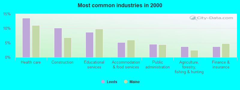
- Health care (13.5%)
- Construction (10.1%)
- Educational services (8.7%)
- Accommodation & food services (5.2%)
- Public administration (4.5%)
- Agriculture, forestry, fishing & hunting (3.7%)
- Finance & insurance (3.7%)

- Construction (17.6%)
- Agriculture, forestry, fishing & hunting (5.8%)
- Educational services (5.8%)
- Textile mills & textile products (5.4%)
- Transportation equipment (5.2%)
- Repair & maintenance (4.4%)
- Professional, scientific, technical services (3.6%)
- Health care (23.7%)
- Educational services (11.6%)
- Accommodation & food services (7.4%)
- Finance & insurance (7.0%)
- Public administration (6.4%)
- Social assistance (3.6%)
- Food & beverage stores (3.2%)

- Other production occupations, including supervisors (5.2%)
- Other office and administrative support workers, including supervisors (4.6%)
- Other management occupations, except farmers and farm managers (4.4%)
- Electrical equipment mechanics and other installation, maintenance, and repair workers, including supervisors (3.4%)
- Registered nurses (3.2%)
- Nursing, psychiatric, and home health aides (3.2%)
- Metal workers and plastic workers (3.2%)

- Electrical equipment mechanics and other installation, maintenance, and repair workers, including supervisors (6.8%)
- Carpenters (6.0%)
- Driver/sales workers and truck drivers (5.6%)
- Other production occupations, including supervisors (5.6%)
- Metal workers and plastic workers (5.0%)
- Vehicle and mobile equipment mechanics, installers, and repairers (4.8%)
- Other management occupations, except farmers and farm managers (4.2%)
- Other office and administrative support workers, including supervisors (8.0%)
- Nursing, psychiatric, and home health aides (6.0%)
- Secretaries and administrative assistants (5.8%)
- Registered nurses (5.8%)
- Other production occupations, including supervisors (4.8%)
- Other management occupations, except farmers and farm managers (4.6%)
- Financial clerks, except bookkeeping, accounting and auditing clerks (4.0%)
Average climate in Leeds, Maine
Based on data reported by over 4,000 weather stations


(lower is better)
Air Quality Index (AQI) level in 2023 was 63.9. This is about average.
| City: | 63.9 |
| U.S.: | 72.6 |
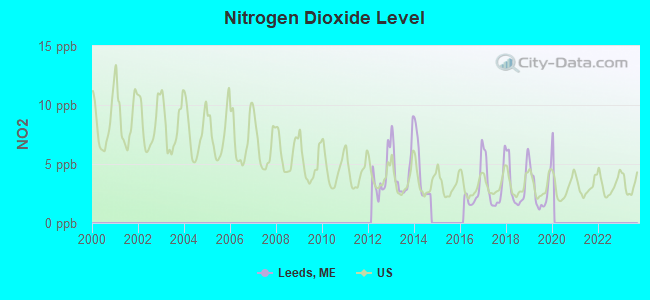
Nitrogen Dioxide (NO2) [ppb] level in 2019 was 2.80. This is significantly better than average. Closest monitor was 13.9 miles away from the city center.
| City: | 2.80 |
| U.S.: | 5.11 |
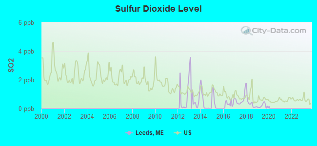
Sulfur Dioxide (SO2) [ppb] level in 2019 was 0.185. This is significantly better than average. Closest monitor was 13.3 miles away from the city center.
| City: | 0.185 |
| U.S.: | 1.515 |
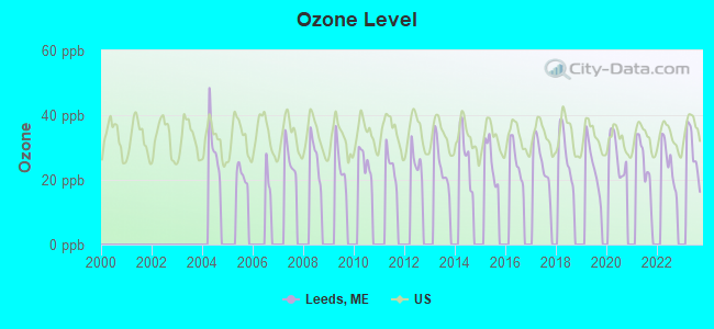
Ozone [ppb] level in 2023 was 28.5. This is about average. Closest monitor was 14.3 miles away from the city center.
| City: | 28.5 |
| U.S.: | 33.3 |
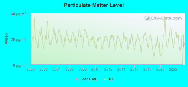
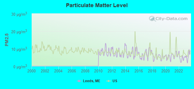
Particulate Matter (PM2.5) [µg/m3] level in 2023 was 5.75. This is significantly better than average. Closest monitor was 14.4 miles away from the city center.
| City: | 5.75 |
| U.S.: | 8.11 |
Earthquake activity:
Leeds-area historical earthquake activity is significantly above Maine state average. It is 76% smaller than the overall U.S. average.On 4/20/2002 at 10:50:47, a magnitude 5.3 (5.3 ML, Depth: 3.0 mi, Class: Moderate, Intensity: VI - VII) earthquake occurred 177.8 miles away from the city center
On 10/16/2012 at 23:12:25, a magnitude 4.7 (4.7 ML, Depth: 10.0 mi, Class: Light, Intensity: IV - V) earthquake occurred 54.7 miles away from the city center
On 4/20/2002 at 10:50:47, a magnitude 5.2 (5.2 MB, 4.2 MS, 5.2 MW, 5.0 MW) earthquake occurred 178.8 miles away from the city center
On 10/7/1983 at 10:18:46, a magnitude 5.3 (5.1 MB, 5.3 LG, 5.1 ML) earthquake occurred 211.2 miles away from the city center
On 1/19/1982 at 00:14:42, a magnitude 4.7 (4.5 MB, 4.7 MD, 4.5 LG) earthquake occurred 91.8 miles away from Leeds center
On 2/26/1999 at 03:38:43, a magnitude 3.8 (3.8 LG, Depth: 2.0 mi, Class: Light, Intensity: II - III) earthquake occurred 32.3 miles away from Leeds center
Magnitude types: regional Lg-wave magnitude (LG), body-wave magnitude (MB), duration magnitude (MD), local magnitude (ML), surface-wave magnitude (MS), moment magnitude (MW)
Natural disasters:
The number of natural disasters in Androscoggin County (28) is a lot greater than the US average (15).Major Disasters (Presidential) Declared: 21
Emergencies Declared: 7
Causes of natural disasters: Floods: 17, Storms: 12, Snows: 7, Winter Storms: 4, Hurricanes: 3, Heavy Rains: 2, Blizzard: 1, Ice Storm: 1, Mudslide: 1, Snowfall: 1, Snowstorm: 1, Tornado: 1, Wind: 1, Other: 2 (Note: some incidents may be assigned to more than one category).
Hospitals and medical centers near Leeds:
- HERITAGE REHAB AND LIVING CTR (Nursing Home, about 7 miles away; WINTHROP, ME)
- SEVILLE PARK PLAZA (Nursing Home, about 13 miles away; AUBURN, ME)
- MONTELLO MANOR (Nursing Home, about 13 miles away; LEWISTON, ME)
- MARSHWOOD CENTER (Nursing Home, about 13 miles away; LEWISTON, ME)
- MARCOTTE HOME (Nursing Home, about 14 miles away; LEWISTON, ME)
- ST MARY'S D'YOUVILLE PAVILION (Nursing Home, about 14 miles away; LEWISTON, ME)
- RUSSELL PARK REHAB AND LIVING (Nursing Home, about 14 miles away; LEWISTON, ME)
Colleges/universities with over 2000 students nearest to Leeds:
- University of Maine at Augusta (about 17 miles; Augusta, ME; Full-time enrollment: 3,204)
- University of Maine at Farmington (about 27 miles; Farmington, ME; FT enrollment: 2,036)
- Saint Joseph's College of Maine (about 37 miles; Standish, ME; FT enrollment: 2,010)
- University of Southern Maine (about 44 miles; Portland, ME; FT enrollment: 6,647)
- Southern Maine Community College (about 45 miles; South Portland, ME; FT enrollment: 4,666)
- University of New England (about 59 miles; Biddeford, ME; FT enrollment: 4,539)
- Husson University (about 76 miles; Bangor, ME; FT enrollment: 2,421)
Public elementary/middle school in Leeds:
- LEEDS CENTRAL SCHOOL (Location: 1185 ROUTE 106, Grades: PK-6)
Points of interest:
Notable locations in Leeds: Libby Pit (A), Riverbend Campground (B), Dead River (C), Leeds Fire Department (D). Display/hide their locations on the map
Church in Leeds: Leeds Community Church (A). Display/hide its location on the map
Cemeteries: East Leeds Cemetery (1), Old Indian Cemetery (2), Knapp Cemetery (3), Carver Cemetery (4), River Grove Cemetery (5), Leeds Plain Cemetery (6), West Leeds Cemetery (7). Display/hide their locations on the map
Lakes and reservoirs: Bonny Pond (A), Island Pond (B), Dead River Reservoir (C). Display/hide their locations on the map
Streams, rivers, and creeks: Allen Stream (A), Dead River (B). Display/hide their locations on the map
Birthplace of: Oliver O. Howard - Army Medal of Honor recipient and Union Army general, Danville Leadbetter - Confederate Army general.
Drinking water stations with addresses in Leeds and their reported violations in the past:
PINE RIDGE HUNTON BROOK ASSN (Population served: 250, Groundwater):Past monitoring violations:CAMP TEKAKWITHA (Population served: 231, Groundwater):
- Follow-up Or Routine LCR Tap M/R - In OCT-01-2011, Contaminant: Lead and Copper Rule. Follow-up actions: St Compliance achieved (DEC-19-2011), St Public Notif requested (JAN-17-2012), St Formal NOV issued (JAN-17-2012), St Public Notif received (JUN-05-2012)
- Follow-up Or Routine LCR Tap M/R - In JUL-11-2004, Contaminant: Lead and Copper Rule. Follow-up actions: St Public Notif requested (APR-22-2005), St Violation/Reminder Notice (APR-22-2005), St Public Notif received (APR-28-2005), St Compliance achieved (SEP-06-2005)
- 2 routine major monitoring violations
Past health violations:Past monitoring violations:
- MCL, Monthly (TCR) - In AUG-2011, Contaminant: Coliform. Follow-up actions: St Public Notif requested (AUG-31-2011), St Formal NOV issued (AUG-31-2011), St Public Notif received (JUN-15-2012), St Compliance achieved (JUN-22-2012)
- MCL, Monthly (TCR) - In JUL-2011, Contaminant: Coliform. Follow-up actions: St Public Notif requested (JUL-29-2011), St Formal NOV issued (JUL-29-2011), St Public Notif received (JUN-15-2012), St Compliance achieved (JUN-22-2012)
- MCL, Monthly (TCR) - In JUN-2011, Contaminant: Coliform. Follow-up actions: St Public Notif requested (JUL-13-2011), St Formal NOV issued (JUL-13-2011), St Public Notif received (JUN-15-2012), St Compliance achieved (JUN-22-2012)
- MCL, Monthly (TCR) - In AUG-2007, Contaminant: Coliform. Follow-up actions: St Public Notif requested (AUG-29-2007), St Formal NOV issued (AUG-29-2007), St Compliance achieved (AUG-26-2011), St Intentional no-action (SEP-15-2011)
- MCL, Monthly (TCR) - In JUL-2007, Contaminant: Coliform. Follow-up actions: St Violation/Reminder Notice (2 times from JUL-17-2007 to JUL-17-2007), St Public Notif requested (2 times from JUL-17-2007 to JUL-17-2007), St Public Notif received (JUL-11-2008), St Compliance achieved (JUL-15-2008)
- Monitoring, Repeat Major (TCR) - In AUG-2010, Contaminant: Coliform (TCR). Follow-up actions: St Public Notif requested (AUG-31-2010), St Formal NOV issued (AUG-31-2010), St Compliance achieved (AUG-22-2011), St Public Notif received (JUN-15-2012)
- 4 routine major monitoring violations
- 4 regular monitoring violations
Drinking water stations with addresses in Leeds that have no violations reported:
- SPRINGBROOK GOLF CLUB (Population served: 250, Primary Water Source Type: Groundwater)
- RIVERBEND CAMPGROUND (Population served: 250, Primary Water Source Type: Groundwater)
- TURNER COMMUNITY HEALTH CENTER (Population served: 54, Primary Water Source Type: Groundwater)
- SPRING ROCK PARK (Population served: 50, Primary Water Source Type: Groundwater)
- D F D RUSSELL MEDICAL CENTER (Population served: 25, Primary Water Source Type: Groundwater)
| This town: | 2.6 people |
| Maine: | 2.3 people |
| This town: | 73.2% |
| Whole state: | 62.9% |
| This town: | 10.4% |
| Whole state: | 9.4% |
Likely homosexual households (counted as self-reported same-sex unmarried-partner households)
- Lesbian couples: 0.4% of all households
- Gay men: 0.1% of all households
| This town: | 9.8% |
| Whole state: | 10.9% |
| This town: | 3.0% |
| Whole state: | 4.1% |
For population 15 years and over in Leeds:
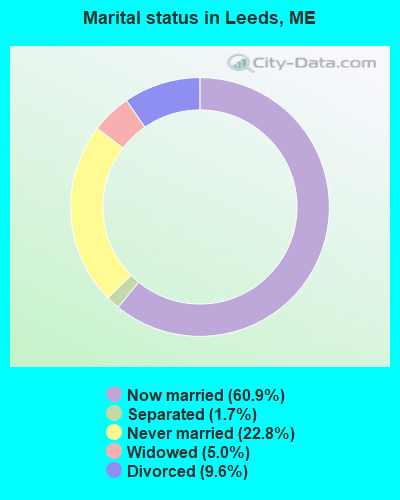
- Never married: 22.8%
- Now married: 60.9%
- Separated: 1.7%
- Widowed: 5.0%
- Divorced: 9.6%
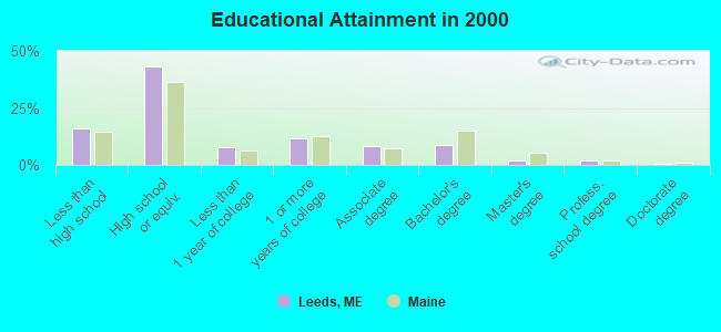
For population 25 years and over in Leeds:
- High school or higher: 83.8%
- Bachelor's degree or higher: 12.8%
- Graduate or professional degree: 4.3%
- Unemployed: 3.8%
- Mean travel time to work (commute): 32.6 minutes
| Here: | 10.3 |
| Maine average: | 11.2 |
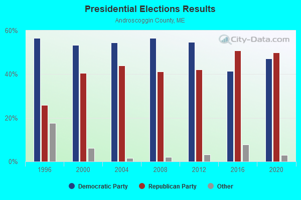
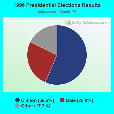
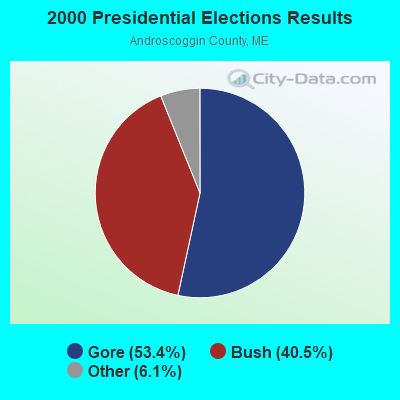
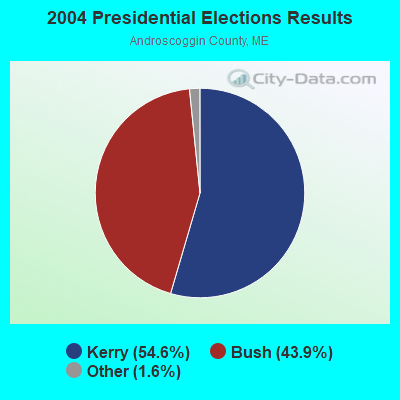

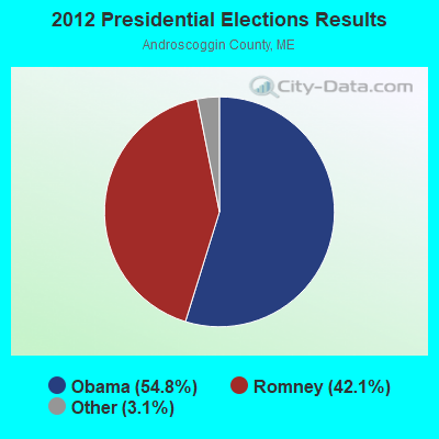

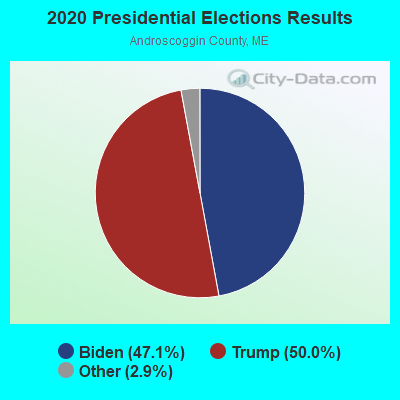
Graphs represent county-level data. Detailed 2008 Election Results
Religion statistics for Leeds, ME (based on Androscoggin County data)
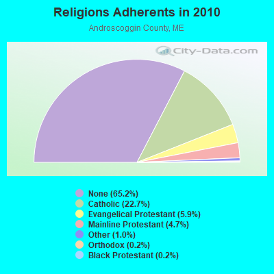
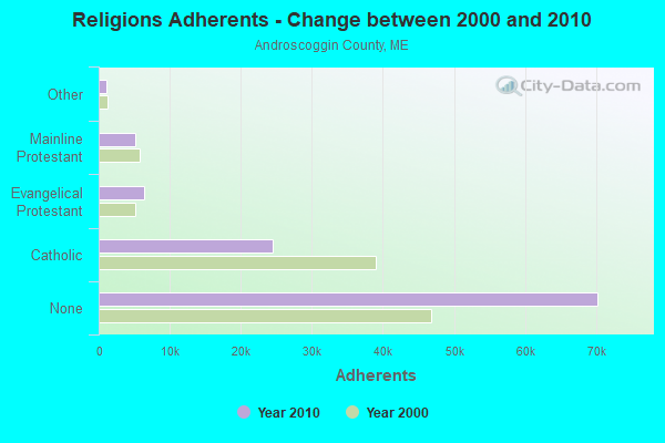
| Religion | Adherents | Congregations |
|---|---|---|
| Catholic | 24,480 | 6 |
| Evangelical Protestant | 6,383 | 37 |
| Mainline Protestant | 5,082 | 27 |
| Other | 1,097 | 8 |
| Orthodox | 225 | 1 |
| Black Protestant | 182 | 1 |
| None | 70,253 | - |
Food Environment Statistics:
| Androscoggin County: | 1.69 / 10,000 pop. |
| State: | 2.80 / 10,000 pop. |
| Androscoggin County: | 0.19 / 10,000 pop. |
| Maine: | 0.14 / 10,000 pop. |
| Androscoggin County: | 1.97 / 10,000 pop. |
| State: | 2.20 / 10,000 pop. |
| Androscoggin County: | 5.90 / 10,000 pop. |
| State: | 5.75 / 10,000 pop. |
| Here: | 7.87 / 10,000 pop. |
| Maine: | 11.02 / 10,000 pop. |
| Androscoggin County: | 8.0% |
| Maine: | 8.2% |
| Androscoggin County: | 27.9% |
| State: | 25.0% |
Strongest AM radio stations in Leeds:
- WTME (780 AM; 10 kW; RUMFORD, ME; Owner: MOUNTAIN VALLEY BROADCASTING, INC.)
- WFAU (1280 AM; 5 kW; GARDINER, ME; Owner: CAPSTAR TX LIMITED PARTNERSHIP)
- WLAM (1470 AM; 5 kW; LEWISTON, ME; Owner: RADIO PARTNERS OF MAINE, L.P.)
- WSKW (1160 AM; 10 kW; SKOWHEGAN, ME; Owner: MOUNTAIN WIRELESS, INCORPORATED)
- WMTW (870 AM; 10 kW; GORHAM, ME; Owner: RADIO PARTNERS OF MAINE, L.P.)
- WGAN (560 AM; 5 kW; PORTLAND, ME; Owner: SAGA COMMUNICATIONS OF NEW ENGLAND, LLC)
- WCNM (1240 AM; 1 kW; LEWISTON, ME; Owner: CHRISTIAN FAMILY RADIO, INC.)
- WRKO (680 AM; 50 kW; BOSTON, MA; Owner: ENTERCOM BOSTON LICENSE, LLC)
- WEZW (1400 AM; 1 kW; AUGUSTA, ME; Owner: CITADEL BROADCASTING COMPANY)
- WEEI (850 AM; 50 kW; BOSTON, MA; Owner: ENTERCOM BOSTON LICENSE, LLC)
- WMDR (1340 AM; 1 kW; AUGUSTA, ME; Owner: LIGHT OF LIFE MINISTRIES, INC.)
- WBZ (1030 AM; 50 kW; BOSTON, MA; Owner: INFINITY BROADCASTING OPERATIONS, INC.)
- WZAN (970 AM; 5 kW; PORTLAND, ME; Owner: SAGA COMMUNICATIONS OF NEW ENGLAND, LLC)
Strongest FM radio stations in Leeds:
- WCYI (93.9 FM; LEWISTON, ME; Owner: CITADEL BROADCASTING COMPANY)
- WPKQ (103.7 FM; NORTH CONWAY, NH; Owner: CITADEL BROADCASTING COMPANY)
- WHOM (94.9 FM; MT. WASHINGTON, NH; Owner: CITADEL BROADCASTING COMPANY)
- WBLM (102.9 FM; PORTLAND, ME; Owner: CITADEL BROADCASTING COMPANY)
- WLOB-FM (96.3 FM; RUMFORD, ME; Owner: ATLANTIC COAST RADIO, LLC)
- WMEA (90.1 FM; PORTLAND, ME; Owner: MAINE PUBLIC BROADCASTING CORPORATION)
- WTHT (107.5 FM; LEWISTON, ME; Owner: RADIO PARTNERS OF MAINE, L.P.)
- WTOS-FM (105.1 FM; SKOWHEGAN, ME; Owner: CAPSTAR TX LIMITED PARTNERSHIP)
- WTBM (100.7 FM; MEXICO, ME; Owner: MOUNTAIN VALLEY BROADCASTING, INC.)
- WBCI (105.9 FM; BATH, ME; Owner: BLOUNT COMMUNICATIONS, INC.)
- WABK-FM (104.3 FM; GARDINER, ME; Owner: CAPSTAR TX LIMITED PARTNERSHIP)
- WKCG (101.3 FM; AUGUSTA, ME; Owner: CAPSTAR TX LIMITED PARTNERSHIP)
- WMEK-FM (99.9 FM; AUBURN, ME; Owner: RADIO PARTNERS OF MAINE, L.P.)
- WJBQ (97.9 FM; PORTLAND, ME; Owner: CITADEL BROADCASTING COMPANY)
- WWWA (95.3 FM; WINSLOW, ME; Owner: LIGHT OF LIFE MINISTRIES, INC.)
- WMME-FM (92.3 FM; AUGUSTA, ME; Owner: CITADEL BROADCASTING COMPANY)
- WMEP (90.5 FM; CAMDEN, ME; Owner: MAINE PUBLIC BROADCASTING CORP.)
- WQSS (102.5 FM; CAMDEN, ME; Owner: CLEAR CHANNEL BROADCASTING LICENSES, INC.)
- WCLZ (98.9 FM; BRUNSWICK, ME; Owner: CITADEL BROADCASTING COMPANY)
- WMTW-FM (106.7 FM; NORTH WINDHAM, ME; Owner: RADIO PARTNERS OF MAINE, L.P.)
TV broadcast stations around Leeds:
- WPFO (Channel 23; WATERVILLE, ME; Owner: CMCG PORTLAND LICENSE LLC)
- WCBB (Channel 10; AUGUSTA, ME; Owner: MAINE PUBLIC BROADCASTING CORP.)
- WGME-TV (Channel 13; PORTLAND, ME; Owner: WGME LICENSEE, LLC)
- WMTW-TV (Channel 8; POLAND SPRING, ME; Owner: WMTW BROADCAST GROUP, LLC)
- WCSH (Channel 6; PORTLAND, ME; Owner: PACIFIC AND SOUTHERN COMPANY, INC.)
- WPXT (Channel 51; PORTLAND, ME; Owner: HMW, INC.)
- WPME (Channel 35; LEWISTON, ME; Owner: KB PRIME MEDIA LLC)
Medal of Honor Recipients
Medal of Honor Recipient born in Leeds: Oliver O. Howard.
- National Bridge Inventory (NBI) Statistics
- 5Number of bridges
- 66ft / 19.8mTotal length
- 15,186Total average daily traffic
- 757Total average daily truck traffic
- 21,526Total future (year 2036) average daily traffic
FCC Registered Antenna Towers:
6- Edward G Roach, Route 106, Rr1 (Lat: 44.332694 Lon: -70.127194), Type: 60.6, Overall height: 60.6 m, Registrant: Sba Towers, Inc, Eroach@sbasite.Com, , Boca -Raton, Phone: (561) 995-7670
- Edward G Roach, Route 106, Rr1 (Lat: 44.332694 Lon: -70.127194), Type: 60.6, Overall height: 60.6 m, Registrant: Sba Properties, Inc., Eroach@sbasite.Com, , Boca -Raton, Phone: (800) 487-7483
- Edward G Roach, Route 106, Rr1 (Lat: 44.332694 Lon: -70.127194), Type: 60.6, Overall height: 60.6 m, Registrant: Sba Properties, Inc., Eroach@sbasite.Com, , Boca -Raton, Phone: (800) 487-7483
- Edward G Roach, Route 106, Rr1 (Lat: 44.332694 Lon: -70.127194), Type: 60.6, Structure height: 23001 m, Overall height: 60.6 m, Registrant: Sba Towers, LLC, Eroach@sbasite.Com, , Boca -Raton, Phone: (561) 995-7670
- Esward G Roach, 1754 Route 106 (Me05253-S) (Lat: 44.332639 Lon: -70.127028), Type: 60.7, Structure height: 23001 m, Overall height: 57.9 m, Registrant: Sba Towers, LLC, Eroach@sbasite.Com, , Boca -Raton, Phone: (561) 995-7670
- Edward G Roach, 1754 Route 106 (Me05253-S) (Lat: 44.332639 Lon: -70.127028), Type: 60.7, Structure height: 23001 m, Overall height: 57.9 m, Registrant: Sba Towers, LLC, Eroach@sbasite.Com, , Boca -Raton, Phone: (561) 995-7670
FCC Registered Broadcast Land Mobile Towers:
2- 20 Ridge Road 1/10 Mile Off Rt 106 (Lat: 44.309222 Lon: -70.122833), Type: Tower, Structure height: 24.1 m, Overall height: 34 m, Call Sign: KNIQ349,
Assigned Frequencies: 154.115 MHz, Grant Date: 03/13/2024, Expiration Date: 06/01/2034, Certifier: Peter Van Gagnon, Registrant: County Of Androscoggin, 2 College Street, Lewiston, ME 04240-7101, Phone: (207) 784-0147, Fax: (207) 795-8938, Email:
- Eoc Fire Sta Town Garage Dump Rd 1/10 Mi Off Rt 106 (Lat: 44.309222 Lon: -70.122833), Type: Tower, Structure height: 24 m, Overall height: 34 m, Call Sign: WNAJ931,
Assigned Frequencies: 154.265 MHz, 154.310 MHz, Grant Date: 03/16/2015, Expiration Date: 03/08/2025, Certifier: Peter Van Gagnon, Registrant: County Of Androscoggin, 2 College Street, Lewiston, ME 04240-7101, Phone: (207) 784-0147, Fax: (207) 795-8938, Email:
FCC Registered Microwave Towers:
4- Leeds, 1754 Route 106 (Lat: 44.332611 Lon: -70.127028), Type: Mtower, Structure height: 57.6 m, Overall height: 59.4 m, Call Sign: WQRF219,
Assigned Frequencies: 10815.0 MHz, 10815.0 MHz, 10815.0 MHz, 10815.0 MHz, 10815.0 MHz, 10815.0 MHz, 10815.0 MHz, 10815.0 MHz, 10815.0 MHz, Grant Date: 04/30/2013, Expiration Date: 04/30/2023, Cancellation Date: 10/22/2020, Certifier: Jessica B Lyons, Registrant: At&t Mobility LLC, 208 S. Akard Street, Room 2100, Dallas, TX 75202, Phone: (855) 699-7073, Email:
- Leeds South, 434 Quaker Ridge Rd (Lat: 44.256944 Lon: -70.130611), Type: Gtower, Structure height: 42.7 m, Overall height: 49.1 m, Call Sign: WQRF603,
Assigned Frequencies: 10775.0 MHz, 10775.0 MHz, 10775.0 MHz, 10775.0 MHz, 10775.0 MHz, 10775.0 MHz, 10775.0 MHz, 10775.0 MHz, 10775.0 MHz, Grant Date: 05/02/2013, Expiration Date: 05/02/2023, Cancellation Date: 04/15/2020, Certifier: Jessica B Lyons, Registrant: At&t Services, Inc., 208 S. Akard Street, Room 2100, Dallas, TX 75202, Phone: (855) 699-7073, Email:
- LEEDS TOWER, 434 Quaker Ridge Rd (Lat: 44.256944 Lon: -70.130611), Type: Gtower, Structure height: 39.6 m, Overall height: 46 m, Call Sign: WRFI269,
Assigned Frequencies: 11075.0 MHz, 11075.0 MHz, 11075.0 MHz, 11075.0 MHz, 11075.0 MHz, 11075.0 MHz, 11075.0 MHz, 11075.0 MHz, 11075.0 MHz, 10915.0 MHz... (+7 more), Grant Date: 03/06/2020, Expiration Date: 03/06/2030, Certifier: Martin Fournier, Registrant: Dirigo Wireless, 41 Lewiston Rd, Gray, ME 04039, Phone: (207) 513-1110, Email:
- Leeds, 434 Quaker Ridge Rd (Lat: 44.256944 Lon: -70.130611), Type: Ltower, Structure height: 44 m, Overall height: 45 m, Call Sign: WRFW908,
Assigned Frequencies: 11075.0 MHz, 11075.0 MHz, 11075.0 MHz, 11075.0 MHz, Grant Date: 05/19/2020, Expiration Date: 05/19/2030, Certifier: Raymond Lafrance, Registrant: Intelpath, Hinsdale, IL 60522, Phone: (312) 841-9188, Email:
FCC Registered Amateur Radio Licenses:
19 (See the full list of FCC Registered Amateur Radio Licenses in Leeds)FAA Registered Aircraft:
1- Aircraft: GEMBALA ROBERT F PELICAN PL (Category: Land, Seats: 2, Weight: Up to 12,499 Pounds), Engine: Reciprocating
N-Number: 484S, N484S, N-484S, Serial Number: 696, Certificate Issue Date: 06/06/2007
Registrant (Individual): Robert F Gembala, 139 Lakeshore Dr, Leeds, ME 04263
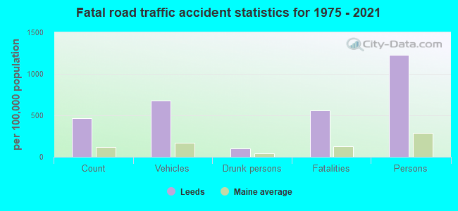
2003 - 2018 National Fire Incident Reporting System (NFIRS) incidents
- Fire incident types reported to NFIRS in Leeds, ME
- 9652.5%Structure Fires
- 4021.9%Outside Fires
- 2815.3%Mobile Property/Vehicle Fires
- 1910.4%Other
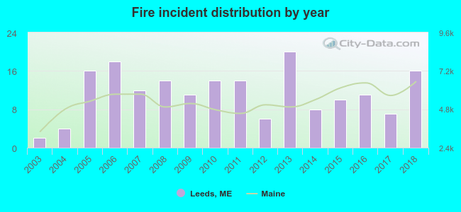 Based on the data from the years 2003 - 2018 the average number of fire incidents per year is 11. The highest number of reported fires - 20 took place in 2013, and the least - 2 in 2003. The data has a rising trend.
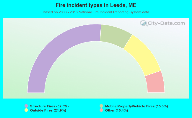 When looking into fire subcategories, the most reports belonged to: Structure Fires (52.5%), and Outside Fires (21.9%).
- 78.1%Fuel oil, kerosene, etc.
- 13.6%Wood
- 5.9%Bottled, tank, or LP gas
- 1.3%Other fuel
- 0.8%Electricity
- 0.3%Coal or coke
- 75.7%Fuel oil, kerosene, etc.
- 17.1%Wood
- 3.6%Electricity
- 1.8%Bottled, tank, or LP gas
- 1.8%No fuel used
Leeds compared to Maine state average:
- Unemployed percentage significantly below state average.
- Black race population percentage significantly below state average.
- Foreign-born population percentage significantly below state average.
- Renting percentage below state average.
- Length of stay since moving in significantly above state average.
- Number of rooms per house significantly below state average.
- House age significantly below state average.
- Percentage of population with a bachelor's degree or higher below state average.
State forum archive:

|
Total of 1 patent application in 2008-2024.