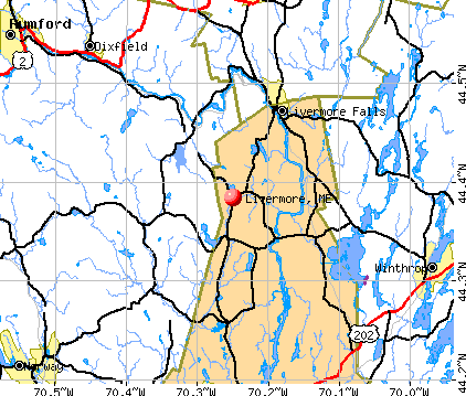
Livermore, Maine
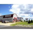
Livermore: Carriage House Cafe
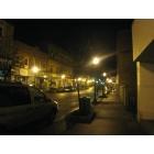
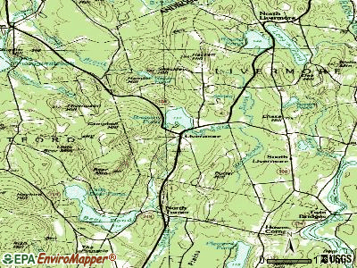
Livermore

Livermore: Ducks in the water by Carl Harrington Sr
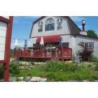
Livermore: this restaurant once a part of the underground railroad
- add
your
Submit your own pictures of this town and show them to the world
- OSM Map
- General Map
- Google Map
- MSN Map
Population change since 2000: -0.5%
 |
| Males: 1,062 | |
| Females: 1,033 |
| Median resident age: | 44.4 years |
| Maine median age: | 43.0 years |
Zip codes: 04253.
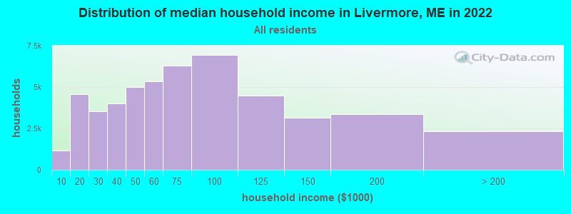
| Livermore: | $68,856 |
| ME: | $69,543 |
Estimated per capita income in 2022: $31,107 (it was $17,706 in 2000)
Livermore town income, earnings, and wages data
Estimated median house or condo value in 2022: $227,418 (it was $79,500 in 2000)
| Livermore: | $227,418 |
| ME: | $290,600 |
Mean prices in 2022: all housing units: $249,170; detached houses: $267,476; townhouses or other attached units: $202,361; in 2-unit structures: $200,400; in 3-to-4-unit structures: $182,257; in 5-or-more-unit structures: $238,166; mobile homes: $73,615
Detailed information about poverty and poor residents in Livermore, ME


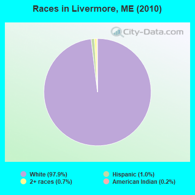
- 2,05197.9%White alone
- 201.0%Hispanic
- 140.7%Two or more races
- 50.2%American Indian alone
- 20.10%Black alone
- 20.10%Asian alone
- 10.05%Other race alone
Races in Livermore detailed stats: ancestries, foreign born residents, place of birth
According to our research of Maine and other state lists, there were 6 registered sex offenders living in Livermore, Maine as of May 08, 2024.
The ratio of all residents to sex offenders in Livermore is 349 to 1.
 Recent articles from our blog. Our writers, many of them Ph.D. graduates or candidates, create easy-to-read articles on a wide variety of topics.

 | Yet another Maine vs New Hampshire moving thread (25 replies) |
| Does Dixfield pass the smell test? (8 replies) |
| property management in Jay or Livermore falls area ? (1 reply) |
| Livermore Falls (2 replies) |
| Presque Isle's 2013 Balloon Fest (4 replies) |
| New Topics Slowed (31 replies) |
Latest news from Livermore, ME collected exclusively by city-data.com from local newspapers, TV, and radio stations
Ancestries: English (23.2%), French (16.9%), United States (11.7%), French Canadian (10.8%), Irish (10.7%), Italian (6.2%).
Current Local Time: EST time zone
Incorporated on 02/28/1795
Elevation: 412 feet
Land area: 37.7 square miles.
Population density: 56 people per square mile (very low).
15 residents are foreign born
| This town: | 0.7% |
| Maine: | 2.9% |
| Livermore town: | 1.4% ($1,107) |
| Maine: | 1.5% ($1,417) |
Nearest city with pop. 50,000+: Portland, ME  (51.5 miles , pop. 64,249).
Nearest city with pop. 200,000+: Boston, MA (150.8 miles , pop. 589,141).
Nearest city with pop. 1,000,000+: Bronx, NY (308.4 miles , pop. 1,332,650).
Nearest cities:
), ), ), ), )Latitude: 44.41 N, Longitude: 70.22 W
Area code commonly used in this area: 207

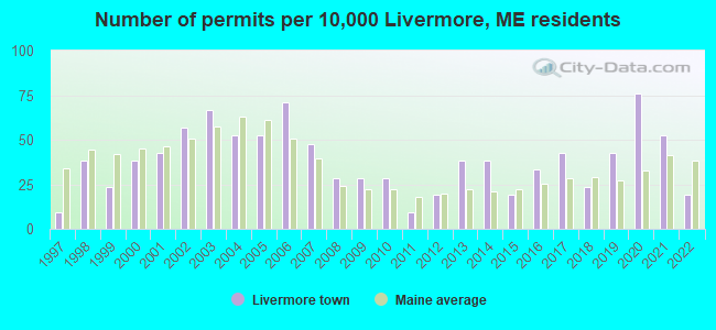
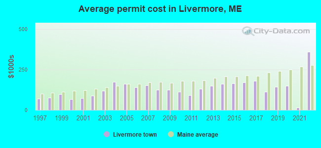
Single-family new house construction building permits:
- 2022: 4 buildings, average cost: $359,000
- 2021: 11 buildings, average cost: $16,400
- 2020: 16 buildings, average cost: $150,000
- 2019: 9 buildings, average cost: $142,700
- 2018: 5 buildings, average cost: $112,600
- 2017: 9 buildings, average cost: $181,100
- 2016: 7 buildings, average cost: $169,400
- 2015: 4 buildings, average cost: $162,500
- 2014: 8 buildings, average cost: $159,800
- 2013: 8 buildings, average cost: $148,500
- 2012: 4 buildings, average cost: $130,500
- 2011: 2 buildings, average cost: $90,500
- 2010: 6 buildings, average cost: $112,200
- 2009: 6 buildings, average cost: $124,200
- 2008: 6 buildings, average cost: $124,500
- 2007: 10 buildings, average cost: $152,300
- 2006: 15 buildings, average cost: $140,100
- 2005: 11 buildings, average cost: $159,800
- 2004: 11 buildings, average cost: $172,700
- 2003: 14 buildings, average cost: $118,200
- 2002: 12 buildings, average cost: $89,400
- 2001: 9 buildings, average cost: $73,900
- 2000: 8 buildings, average cost: $67,000
- 1999: 5 buildings, average cost: $97,400
- 1998: 8 buildings, average cost: $75,000
- 1997: 2 buildings, average cost: $70,000
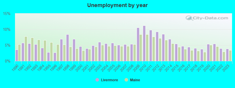
| Here: | 3.9% |
| Maine: | 3.4% |
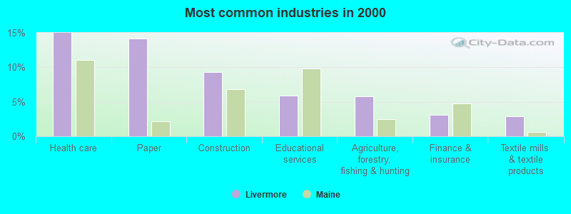
- Health care (15.0%)
- Paper (14.2%)
- Construction (9.3%)
- Educational services (5.9%)
- Agriculture, forestry, fishing & hunting (5.8%)
- Finance & insurance (3.1%)
- Textile mills & textile products (2.9%)
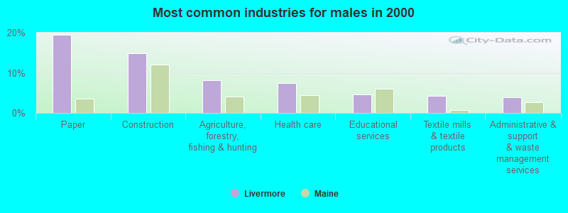
- Paper (19.4%)
- Construction (14.8%)
- Agriculture, forestry, fishing & hunting (8.1%)
- Health care (7.5%)
- Educational services (4.6%)
- Textile mills & textile products (4.3%)
- Administrative & support & waste management services (3.8%)
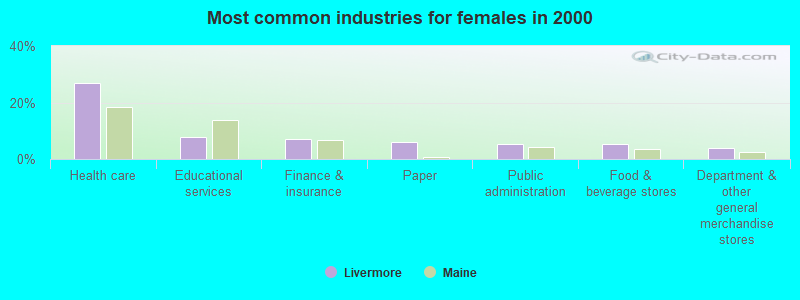
- Health care (26.8%)
- Educational services (7.9%)
- Finance & insurance (7.2%)
- Paper (6.0%)
- Public administration (5.5%)
- Food & beverage stores (5.2%)
- Department & other general merchandise stores (4.0%)
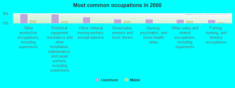
- Other production occupations, including supervisors (7.8%)
- Electrical equipment mechanics and other installation, maintenance, and repair workers, including supervisors (7.5%)
- Other material moving workers, except laborers (5.0%)
- Driver/sales workers and truck drivers (3.5%)
- Nursing, psychiatric, and home health aides (3.5%)
- Other sales and related occupations, including supervisors (3.1%)
- Fishing, hunting, and forestry occupations (3.0%)
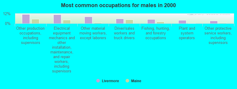
- Other production occupations, including supervisors (11.1%)
- Electrical equipment mechanics and other installation, maintenance, and repair workers, including supervisors (11.0%)
- Other material moving workers, except laborers (8.3%)
- Driver/sales workers and truck drivers (5.7%)
- Fishing, hunting, and forestry occupations (4.9%)
- Plant and system operators (3.8%)
- Other protective service workers, including supervisors (3.2%)
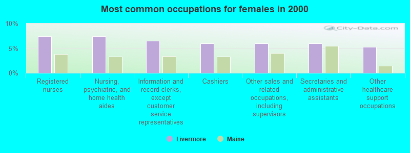
- Registered nurses (7.4%)
- Nursing, psychiatric, and home health aides (7.4%)
- Information and record clerks, except customer service representatives (6.5%)
- Cashiers (6.0%)
- Other sales and related occupations, including supervisors (6.0%)
- Secretaries and administrative assistants (6.0%)
- Other healthcare support occupations (5.2%)
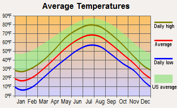
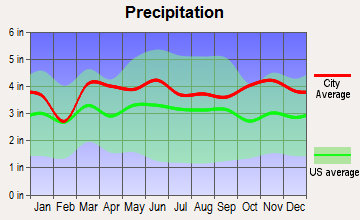
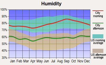
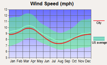
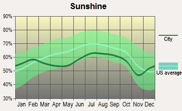
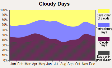
Average climate in Livermore, Maine
Based on data reported by over 4,000 weather stations

(lower is better)
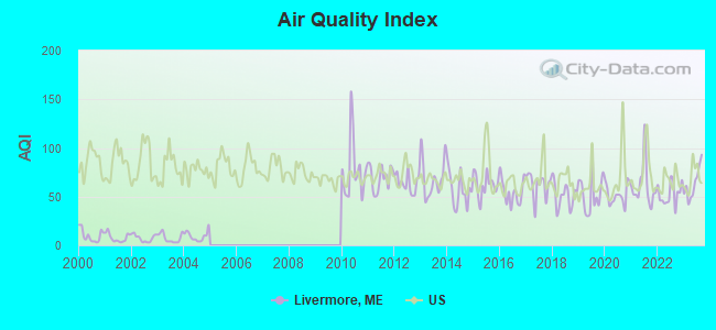
Air Quality Index (AQI) level in 2023 was 63.3. This is about average.
| City: | 63.3 |
| U.S.: | 72.6 |
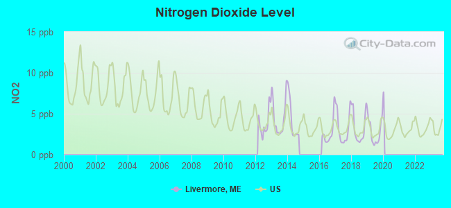
Nitrogen Dioxide (NO2) [ppb] level in 2019 was 2.80. This is significantly better than average. Closest monitor was 4.2 miles away from the city center.
| City: | 2.80 |
| U.S.: | 5.11 |
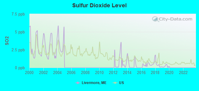
Sulfur Dioxide (SO2) [ppb] level in 2019 was 0.185. This is significantly better than average. Closest monitor was 4.2 miles away from the city center.
| City: | 0.185 |
| U.S.: | 1.515 |
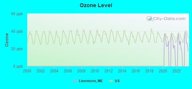
Ozone [ppb] level in 2023 was 29.5. This is about average. Closest monitor was 4.2 miles away from the city center.
| City: | 29.5 |
| U.S.: | 33.3 |
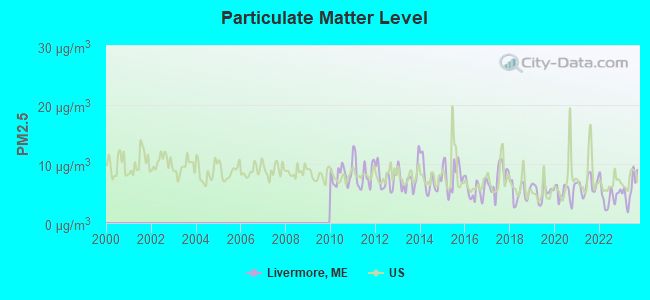
Particulate Matter (PM2.5) [µg/m3] level in 2023 was 5.78. This is significantly better than average. Closest monitor was 18.4 miles away from the city center.
| City: | 5.78 |
| U.S.: | 8.11 |
Earthquake activity:
Livermore-area historical earthquake activity is significantly above Maine state average. It is 76% smaller than the overall U.S. average.On 4/20/2002 at 10:50:47, a magnitude 5.3 (5.3 ML, Depth: 3.0 mi, Class: Moderate, Intensity: VI - VII) earthquake occurred 171.6 miles away from the city center
On 10/16/2012 at 23:12:25, a magnitude 4.7 (4.7 ML, Depth: 10.0 mi, Class: Light, Intensity: IV - V) earthquake occurred 60.1 miles away from Livermore center
On 4/20/2002 at 10:50:47, a magnitude 5.2 (5.2 MB, 4.2 MS, 5.2 MW, 5.0 MW) earthquake occurred 172.6 miles away from the city center
On 10/7/1983 at 10:18:46, a magnitude 5.3 (5.1 MB, 5.3 LG, 5.1 ML) earthquake occurred 206.6 miles away from the city center
On 1/19/1982 at 00:14:42, a magnitude 4.7 (4.5 MB, 4.7 MD, 4.5 LG) earthquake occurred 92.9 miles away from the city center
On 2/26/1999 at 03:38:43, a magnitude 3.8 (3.8 LG, Depth: 2.0 mi, Class: Light, Intensity: II - III) earthquake occurred 35.1 miles away from Livermore center
Magnitude types: regional Lg-wave magnitude (LG), body-wave magnitude (MB), duration magnitude (MD), local magnitude (ML), surface-wave magnitude (MS), moment magnitude (MW)
Natural disasters:
The number of natural disasters in Androscoggin County (28) is a lot greater than the US average (15).Major Disasters (Presidential) Declared: 21
Emergencies Declared: 7
Causes of natural disasters: Floods: 17, Storms: 12, Snows: 7, Winter Storms: 4, Hurricanes: 3, Heavy Rains: 2, Blizzard: 1, Ice Storm: 1, Mudslide: 1, Snowfall: 1, Snowstorm: 1, Tornado: 1, Wind: 1, Other: 2 (Note: some incidents may be assigned to more than one category).
Hospitals and medical centers near Livermore:
- VICTORIAN VILLA NURSING HOME (Nursing Home, about 6 miles away; CANTON, ME)
- HERITAGE REHAB AND LIVING CTR (Nursing Home, about 15 miles away; WINTHROP, ME)
- DIXFIELD HEALTH CARE CENTER (Nursing Home, about 15 miles away; DIXFIELD, ME)
- SANDY RIVER CENTER (Nursing Home, about 15 miles away; FARMINGTON, ME)
located in Livermore:
Colleges/universities with over 2000 students nearest to Livermore:
- University of Maine at Farmington (about 19 miles; Farmington, ME; Full-time enrollment: 2,036)
- University of Maine at Augusta (about 22 miles; Augusta, ME; FT enrollment: 3,204)
- Saint Joseph's College of Maine (about 43 miles; Standish, ME; FT enrollment: 2,010)
- University of Southern Maine (about 52 miles; Portland, ME; FT enrollment: 6,647)
- Southern Maine Community College (about 53 miles; South Portland, ME; FT enrollment: 4,666)
- University of New England (about 67 miles; Biddeford, ME; FT enrollment: 4,539)
- Husson University (about 77 miles; Bangor, ME; FT enrollment: 2,421)
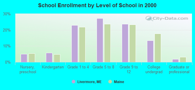
Public elementary/middle school in Livermore:
- LIVERMORE ELEMENTARY SCHOOL (Location: 107 GIBBS MILL ROAD, Grades: PK-5)
Points of interest:
Notable locations in Livermore: Norlands Living History Center (A), Northstar Ambulance Livermore (B), Livermore Fire Department (C). Display/hide their locations on the map
Church in Livermore: Norland Church (A). Display/hide its location on the map
Cemeteries: Alden Cemetery (1), True Cemetery (2), Perley Cemetery (3), Lamb Cemetery (4), Goding Cemetery (5), Cheney Private Yard (6), Boothby Cemetery (7). Display/hide their locations on the map
Lakes and reservoirs: Bartlett Pond (A), Long Pond (B), Nelson Pond (C), Round Pond (D), Androscoggin River Reservoir (E), Brettuns Pond (F). Display/hide their locations on the map
Streams, rivers, and creeks: Ford Brook (A), Fish Meadow Brook (B), Leavitt Brook (C), Keith Brook (D), Beals Brook (E). Display/hide their locations on the map
Birthplace of: Cadwallader C. Washburn - General Mills founder and politician, Elihu B. Washburne - Politician and diplomat, Eugene L. Norton - Politician, William D. Washburn - Politician, Israel Washburn, Jr. - Politician, Timothy O. Howe - Politician, Dorilus Morrison - Politician.
Drinking water stations with addresses in Livermore and their reported violations in the past:
TAVERN AT MAPLE LANE (Population served: 650, Groundwater):Past monitoring violations:CARRIAGE HOUSE CAFE (Population served: 375, Groundwater):
- 15 routine major monitoring violations
Past monitoring violations:NORLANDS LIVING HISTORY CENTER (Population served: 158, Groundwater):
- 4 routine major monitoring violations
- 9 regular monitoring violations
Past monitoring violations:
- 3 routine major monitoring violations
Drinking water stations with addresses in Livermore that have no violations reported:
- BRIGHT IDEAS CHILD CARE CENTER (Population served: 68, Primary Water Source Type: Groundwater)
| This town: | 2.4 people |
| Maine: | 2.3 people |
| This town: | 69.7% |
| Whole state: | 62.9% |
| This town: | 8.7% |
| Whole state: | 9.4% |
Likely homosexual households (counted as self-reported same-sex unmarried-partner households)
- Lesbian couples: 0.2% of all households
- Gay men: 0.0% of all households
| This town: | 5.1% |
| Whole state: | 10.9% |
| This town: | 0.3% |
| Whole state: | 4.1% |
For population 15 years and over in Livermore:
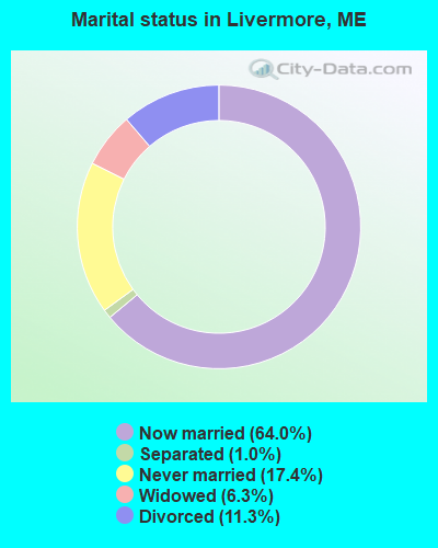
- Never married: 17.4%
- Now married: 64.0%
- Separated: 1.0%
- Widowed: 6.3%
- Divorced: 11.3%
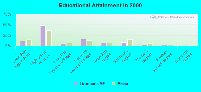
For population 25 years and over in Livermore:
- High school or higher: 88.3%
- Bachelor's degree or higher: 11.2%
- Graduate or professional degree: 3.3%
- Unemployed: 4.9%
- Mean travel time to work (commute): 30.5 minutes
| Here: | 8.8 |
| Maine average: | 11.2 |
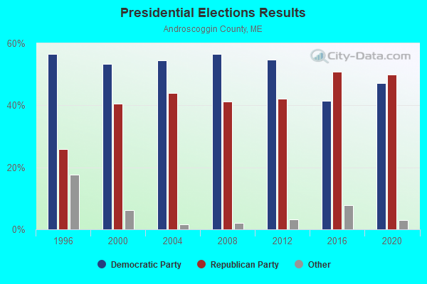
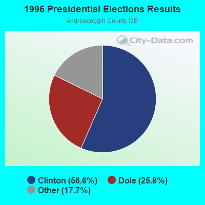
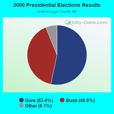
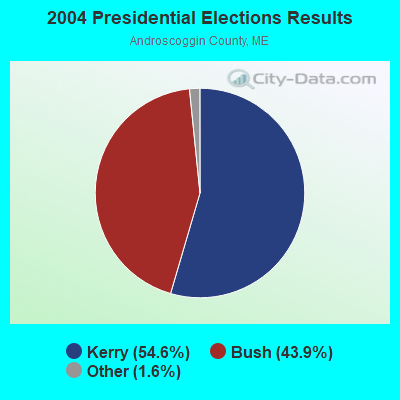
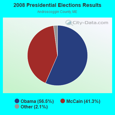
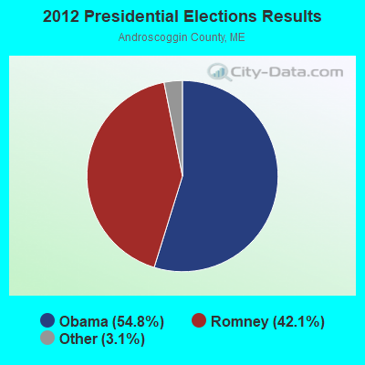
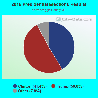
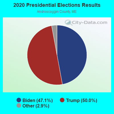
Graphs represent county-level data. Detailed 2008 Election Results
Religion statistics for Livermore, ME (based on Androscoggin County data)
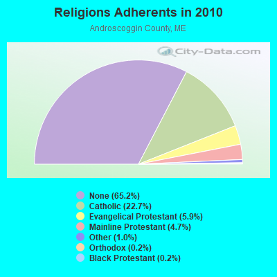
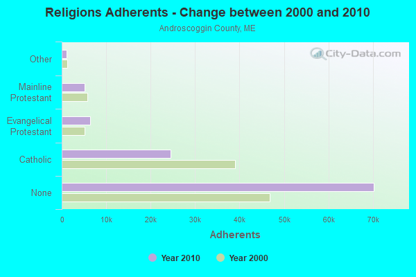
| Religion | Adherents | Congregations |
|---|---|---|
| Catholic | 24,480 | 6 |
| Evangelical Protestant | 6,383 | 37 |
| Mainline Protestant | 5,082 | 27 |
| Other | 1,097 | 8 |
| Orthodox | 225 | 1 |
| Black Protestant | 182 | 1 |
| None | 70,253 | - |
Food Environment Statistics:
| This county: | 1.69 / 10,000 pop. |
| Maine: | 2.80 / 10,000 pop. |
| This county: | 0.19 / 10,000 pop. |
| Maine: | 0.14 / 10,000 pop. |
| This county: | 1.97 / 10,000 pop. |
| State: | 2.20 / 10,000 pop. |
| Androscoggin County: | 5.90 / 10,000 pop. |
| Maine: | 5.75 / 10,000 pop. |
| Androscoggin County: | 7.87 / 10,000 pop. |
| Maine: | 11.02 / 10,000 pop. |
| Here: | 8.0% |
| Maine: | 8.2% |
| Here: | 27.9% |
| Maine: | 25.0% |
Businesses in Livermore, ME
- Ace Hardware: 1
- Decora Cabinetry: 2
- MasterBrand Cabinets: 2
Strongest AM radio stations in Livermore:
- WTME (780 AM; 10 kW; RUMFORD, ME; Owner: MOUNTAIN VALLEY BROADCASTING, INC.)
- WFAU (1280 AM; 5 kW; GARDINER, ME; Owner: CAPSTAR TX LIMITED PARTNERSHIP)
- WSKW (1160 AM; 10 kW; SKOWHEGAN, ME; Owner: MOUNTAIN WIRELESS, INCORPORATED)
- WLAM (1470 AM; 5 kW; LEWISTON, ME; Owner: RADIO PARTNERS OF MAINE, L.P.)
- WMTW (870 AM; 10 kW; GORHAM, ME; Owner: RADIO PARTNERS OF MAINE, L.P.)
- WRKO (680 AM; 50 kW; BOSTON, MA; Owner: ENTERCOM BOSTON LICENSE, LLC)
- WGAN (560 AM; 5 kW; PORTLAND, ME; Owner: SAGA COMMUNICATIONS OF NEW ENGLAND, LLC)
- WEEI (850 AM; 50 kW; BOSTON, MA; Owner: ENTERCOM BOSTON LICENSE, LLC)
- WBZ (1030 AM; 50 kW; BOSTON, MA; Owner: INFINITY BROADCASTING OPERATIONS, INC.)
- WCRN (830 AM; 50 kW; WORCESTER, MA; Owner: CARTER BROADCASTING CORPORATION)
- WCNM (1240 AM; 1 kW; LEWISTON, ME; Owner: CHRISTIAN FAMILY RADIO, INC.)
- WNNZ (640 AM; 50 kW; WESTFIELD, MA; Owner: CLEAR CHANNEL BROADCASTING LICENSES, INC.)
- WKTQ (1450 AM; 1 kW; SOUTH PARIS, ME; Owner: PENNESSEEWASSEE BROADCASTING CO INC.)
Strongest FM radio stations in Livermore:
- WLOB-FM (96.3 FM; RUMFORD, ME; Owner: ATLANTIC COAST RADIO, LLC)
- WTBM (100.7 FM; MEXICO, ME; Owner: MOUNTAIN VALLEY BROADCASTING, INC.)
- WPKQ (103.7 FM; NORTH CONWAY, NH; Owner: CITADEL BROADCASTING COMPANY)
- WHOM (94.9 FM; MT. WASHINGTON, NH; Owner: CITADEL BROADCASTING COMPANY)
- WTOS-FM (105.1 FM; SKOWHEGAN, ME; Owner: CAPSTAR TX LIMITED PARTNERSHIP)
- WBLM (102.9 FM; PORTLAND, ME; Owner: CITADEL BROADCASTING COMPANY)
- WMEA (90.1 FM; PORTLAND, ME; Owner: MAINE PUBLIC BROADCASTING CORPORATION)
- WCYI (93.9 FM; LEWISTON, ME; Owner: CITADEL BROADCASTING COMPANY)
- WTHT (107.5 FM; LEWISTON, ME; Owner: RADIO PARTNERS OF MAINE, L.P.)
- WKTJ-FM (99.3 FM; FARMINGTON, ME; Owner: FRANKLIN BROADCASTING CORPORATION)
- WWWA (95.3 FM; WINSLOW, ME; Owner: LIGHT OF LIFE MINISTRIES, INC.)
- WJBQ (97.9 FM; PORTLAND, ME; Owner: CITADEL BROADCASTING COMPANY)
- WHQO (107.9 FM; SKOWHEGAN, ME; Owner: MOUNTAIN WIRELESS, INC.)
- WABK-FM (104.3 FM; GARDINER, ME; Owner: CAPSTAR TX LIMITED PARTNERSHIP)
- WMEK-FM (99.9 FM; AUBURN, ME; Owner: RADIO PARTNERS OF MAINE, L.P.)
- WMME-FM (92.3 FM; AUGUSTA, ME; Owner: CITADEL BROADCASTING COMPANY)
- WOXO-FM (92.7 FM; NORWAY, ME; Owner: TRI-COUNTY BROADCASTING, INC.)
- WBCI (105.9 FM; BATH, ME; Owner: BLOUNT COMMUNICATIONS, INC.)
- WKCG (101.3 FM; AUGUSTA, ME; Owner: CAPSTAR TX LIMITED PARTNERSHIP)
TV broadcast stations around Livermore:
- WGME-TV (Channel 13; PORTLAND, ME; Owner: WGME LICENSEE, LLC)
- WPFO (Channel 23; WATERVILLE, ME; Owner: CMCG PORTLAND LICENSE LLC)
- WCBB (Channel 10; AUGUSTA, ME; Owner: MAINE PUBLIC BROADCASTING CORP.)
- WMTW-TV (Channel 8; POLAND SPRING, ME; Owner: WMTW BROADCAST GROUP, LLC)
- WCSH (Channel 6; PORTLAND, ME; Owner: PACIFIC AND SOUTHERN COMPANY, INC.)
- W21BI (Channel 21; FARMINGTON, ME; Owner: TRINITY BROADCASTING NETWORK)
- National Bridge Inventory (NBI) Statistics
- 3Number of bridges
- 49ft / 14.9mTotal length
- 17,187Total average daily traffic
- 858Total average daily truck traffic
- 24,062Total future (year 2036) average daily traffic
FCC Registered Antenna Towers:
6- Richard Houde, 203 Waters Hill Road (Lat: 44.415694 Lon: -70.212639), Type: 59.7, Overall height: 57.9 m, Registrant: Holland & Knight LLP, Pconnolly@hklaw.Com, , Washi-ngton, Phone: (202) 862-5989
- Erik Brooks, 203 Waters Hill Road (Lat: 44.415694 Lon: -70.212639), Type: 59.7, Overall height: 57.9 m, Registrant: Holland & Knight LLP, Pconnolly@hklaw.Com, , Washi-ngton, Phone: (202) 862-5989
- Cayla Gamble, 203 Waters Hill Road (Lat: 44.415694 Lon: -70.212639), Type: 59.7, Structure height: 23001 m, Overall height: 57.9 m, Registrant: Wilkinson Barker Knauer, LLP, Gwerner@wbklaw.Com, , Washi-ngton, Phone: (202) 383-3420
- Cayla Gamble, 203 Waters Hill Road (Lat: 44.415694 Lon: -70.212639), Type: 59.7, Structure height: 23001 m, Overall height: 57.9 m, Registrant: Wilkinson Barker Knauer, LLP, Gwerner@wbklaw.Com, , Washi-ngton, Phone: (202) 383-3420
- Cayla Gamble, 203 Waters Hill Road (Lat: 44.415694 Lon: -70.212639), Type: 59.7, Structure height: 23001 m, Overall height: 57.9 m, Registrant: Wilkinson Barker Knauer, LLP, Gwerner@wbklaw.Com, , Washi-ngton, Phone: (202) 383-3420
- Moose Hill (Lat: 44.483333 Lon: -70.132500), Type: 18.3, Overall height: 6.6 m, Registrant: Yankee Microwave Inc, Microwave@maine.Com, , 1260 Naple-s, Phone: (207) 647-2208
FCC Registered Broadcast Land Mobile Towers:
2- 10 Crash Rd .16 Km Off Rt 4 (Lat: 44.441167 Lon: -70.217000), Type: Pipe, Structure height: 7 m, Overall height: 10 m, Call Sign: WNAJ921,
Assigned Frequencies: 154.265 MHz, 154.310 MHz, Grant Date: 02/02/2015, Expiration Date: 12/30/2024, Registrant: County Of Androscoggin, 2 College Street, Lewiston, ME 04240-7101, Phone: (207) 784-0147, Fax: (207) 795-8938, Email:
- 10 Crash Road .16 Km Off Rte 4 (Lat: 44.441167 Lon: -70.217000), Type: Pipe, Structure height: 7 m, Overall height: 10 m, Call Sign: KNIQ363,
Assigned Frequencies: 154.115 MHz, Grant Date: 03/13/2024, Expiration Date: 06/01/2034, Certifier: Peter Van Gagnon, Registrant: County Of Androscoggin, 2 College Street, Lewiston, ME 04240-7101, Phone: (207) 784-0147, Fax: (207) 795-8938, Email:
FCC Registered Microwave Towers:
2- MOOSE HILL, Moose Hill Rd (Lat: 44.483389 Lon: -70.132556), Type: Tower, Structure height: 23 m, Call Sign: WQAA832,
Assigned Frequencies: 6887.50 MHz, Grant Date: 04/23/2004, Expiration Date: 04/01/2007, Cancellation Date: 09/16/2005, Certifier: Jack Conner, Registrant: Wmtw Broadcast Group, LLC, 99 Danville Corner Rd, Auburn, ME 04210, Phone: (207) 782-1800, Fax: (207) 783-7371, Email:
- Livermore, 203 Waters Hill Road (Lat: 44.415694 Lon: -70.212639), Type: Ltower, Structure height: 58.2 m, Overall height: 59.4 m, Call Sign: WQSC968,
Assigned Frequencies: 11225.0 MHz, 11225.0 MHz, 11225.0 MHz, 11225.0 MHz, 11225.0 MHz, 11225.0 MHz, 11225.0 MHz, 11225.0 MHz, 11225.0 MHz, Grant Date: 09/04/2013, Expiration Date: 09/04/2023, Cancellation Date: 04/15/2020, Certifier: Jessica B Lyons, Registrant: At&t Services, Inc., 208 S. Akard Street, Room 2100, Dallas, TX 75202, Phone: (855) 699-7073, Email:
FCC Registered Amateur Radio Licenses:
8 (See the full list of FCC Registered Amateur Radio Licenses in Livermore)FAA Registered Aircraft:
1- Aircraft: CESSNA 175A (Category: Land, Seats: 4, Weight: Up to 12,499 Pounds, Speed: 105 mph), Engine: CONT MOTOR GO-300 SERIES (175 HP) (Reciprocating)
N-Number: 175JT, N175JT, N-175JT, Serial Number: 56372, Year manufactured: 1959, Airworthiness Date: 12/07/1959, Certificate Issue Date: 03/03/2010
Registrant (Individual): James D Timberlake, Po Box 476, Livermore, ME 04253
2002 - 2018 National Fire Incident Reporting System (NFIRS) incidents
- Fire incident types reported to NFIRS in Livermore, ME
- 14664.9%Structure Fires
- 5022.2%Outside Fires
- 2511.1%Mobile Property/Vehicle Fires
- 41.8%Other
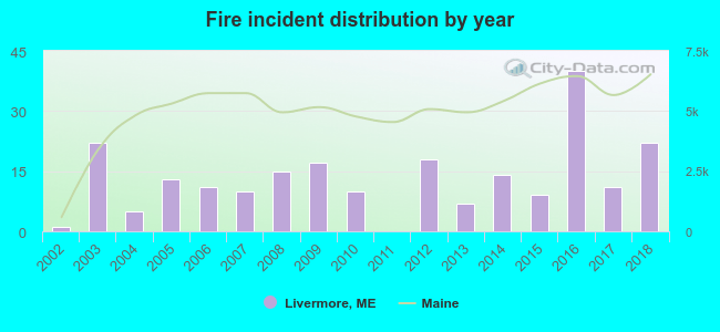 According to the data from the years 2002 - 2018 the average number of fires per year is 13. The highest number of reported fires - 40 took place in 2016, and the least - 0 in 2011. The data has a rising trend.
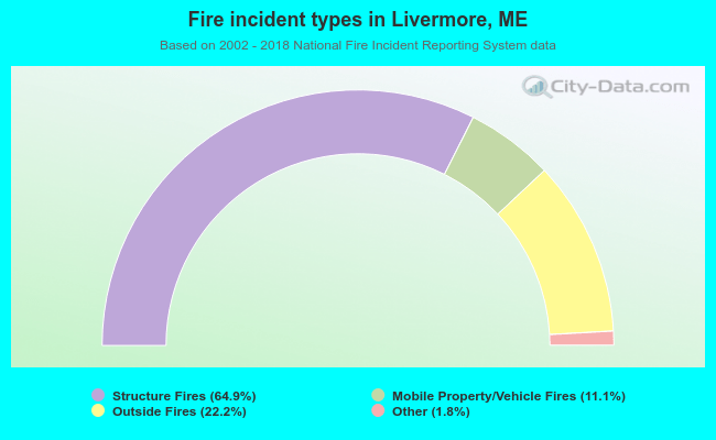 When looking into fire subcategories, the most reports belonged to: Structure Fires (64.9%), and Outside Fires (22.2%).
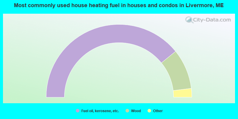
- 78.4%Fuel oil, kerosene, etc.
- 17.8%Wood
- 2.8%Bottled, tank, or LP gas
- 1.1%Electricity
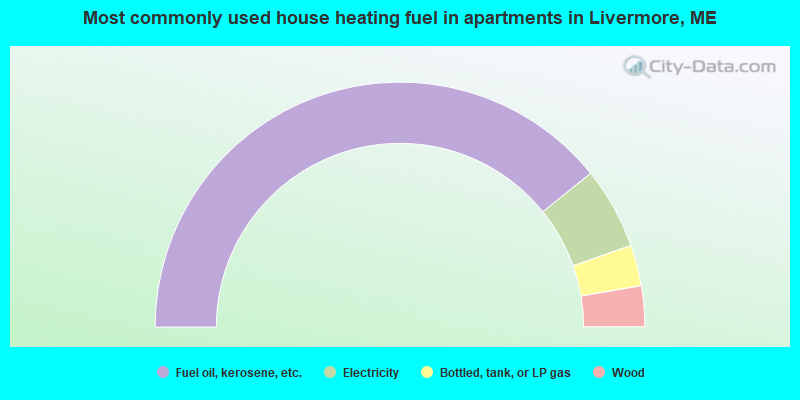
- 78.5%Fuel oil, kerosene, etc.
- 10.8%Electricity
- 5.4%Bottled, tank, or LP gas
- 5.4%Wood
Livermore compared to Maine state average:
- Unemployed percentage below state average.
- Black race population percentage significantly below state average.
- Hispanic race population percentage below state average.
- Foreign-born population percentage significantly below state average.
- Renting percentage below state average.
- Length of stay since moving in significantly above state average.
- Number of rooms per house significantly below state average.
- House age significantly below state average.
- Percentage of population with a bachelor's degree or higher significantly below state average.

|
Total of 4 patent applications in 2008-2024.