Koolaupoko, Hawaii
Submit your own pictures of this place and show them to the world
- OSM Map
- General Map
- Google Map
- MSN Map

| Males: 61,953 | |
| Females: 59,227 |
| Median resident age: | 35.3 years |
| Hawaii median age: | 36.2 years |
Zip code: 96744
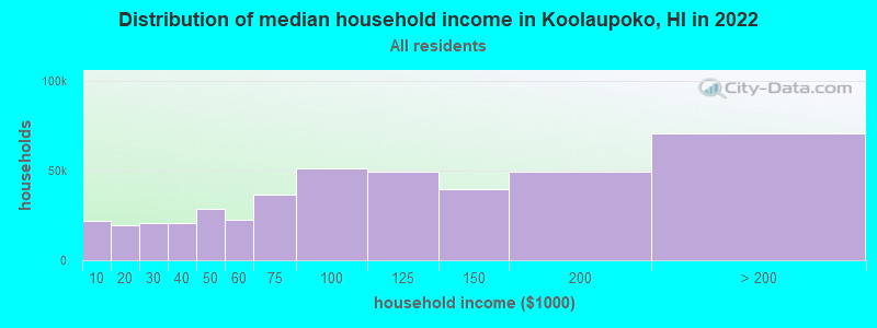
| Koolaupoko: | $123,137 |
| HI: | $92,458 |
Estimated per capita income in 2022: $48,307 (it was $24,368 in 2000)
Koolaupoko CCD income, earnings, and wages data
Estimated median house or condo value in 2022: over $1,000,000 (it was $316,900 in 2000)
| Koolaupoko: | over $1,000,000 |
| HI: | $820,100 |
Mean prices in 2022: all housing units: $999,130; detached houses: over $1,000,000; townhouses or other attached units: $982,127; in 2-unit structures: $920,464; in 3-to-4-unit structures: $717,340; in 5-or-more-unit structures: $577,655; mobile homes: over $1,000,000; occupied boats, rvs, vans, etc.: $319,807
Detailed information about poverty and poor residents in Koolaupoko, HI
Compare current foreclosures near Koolaupoko, HI:
| Photo | Address | Area | Beds / Baths | Price | Details |
|---|---|---|---|---|---|

|
#1
Palolo Avenue
Honolulu, HI 96816
|
1,162 sq. feet
|
1 baths 3 beds |
$799,000
|
show details |

|
#2
-133 Pupupuhi St Unit
Waipahu, HI 96797
|
1,176 sq. feet
|
3 baths 3 beds |
$515,000
|
show details |

|
#3
Richard Ln Apt B613
Honolulu, HI 96819
|
643 sq. feet
|
1 baths 2 beds |
$365,000
|
show details |

|
#4
Alexander St Apt 503
Honolulu, HI 96826
|
625 sq. feet
|
1 baths 1 beds |
$249,900
|
show details |

|
#5
Victoria St Apt 1002
Honolulu, HI 96822
|
930 sq. feet
|
1 baths 2 beds |
$135,000
|
show details |

|
#6
343 Ho Owalea Place
Ewa Beach, HI 96706
|
- sq. feet
|
3 baths 4 beds |
$904,800
|
show details |

|
#7
Hoanoho Pl
Honolulu, HI 96816
|
- sq. feet
|
1 baths 3 beds |
$842,400
|
show details |

|
#8
Keolu Dr Apt C
Kailua, HI 96734
|
1,625 sq. feet
|
3 baths 4 beds |
show details | |

|
#9
Queen St Apt 3405
Honolulu, HI 96814
|
1,151 sq. feet
|
2 baths 2 beds |
show details | |

|
#10
Hui Iwa St Apt 2
Kaneohe, HI 96744
|
1,290 sq. feet
|
3 baths 3 beds |
show details |
| Photo | Address | Area | Beds / Baths | Price | Details |
|---|---|---|---|---|---|

|
#11
-140 Kupuohi Pl
Waipahu, HI 96797
|
1,128 sq. feet
|
2 baths 3 beds |
show details | |

|
#12
Honomu St
Hauula, HI 96717
|
1,008 sq. feet
|
1 baths 3 beds |
show details | |

|
#13
California Ave Apt 20d
Wahiawa, HI 96786
|
782 sq. feet
|
1 baths 2 beds |
show details | |

|
#14
Ala Moana Blvd Apt 705
Honolulu, HI 96814
|
1,222 sq. feet
|
2 baths 2 beds |
show details | |

|
#15
Wahinekoa Pl
Honolulu, HI 96821
|
1,462 sq. feet
|
2 baths 4 beds |
show details | |

|
#16
Noelani St
Pearl City, HI 96782
|
3,224 sq. feet
|
2 baths 6 beds |
show details | |

|
#17
Kaauwai Pl # B
Honolulu, HI 96817
|
1,033 sq. feet
|
3 baths 4 beds |
show details | |

|
#18
Kama Ln
Honolulu, HI 96817
|
720 sq. feet
|
1 baths 3 beds |
show details | |

|
#19
Oswald St
Honolulu, HI 96816
|
1,500 sq. feet
|
2 baths 3 beds |
show details | |

|
#20
Kanekopa Pl
Honolulu, HI 96816
|
1,710 sq. feet
|
3 baths 3 beds |
show details |
| Photo | Address | Area | Beds / Baths | Price | Details |
|---|---|---|---|---|---|

|
#21
Kaweloka St
Pearl City, HI 96782
|
1,935 sq. feet
|
3 baths 4 beds |
show details | |

|
#22
Alohea Ave
Honolulu, HI 96816
|
836 sq. feet
|
1 baths 2 beds |
show details | |

|
#23
Kealoha St
Honolulu, HI 96819
|
3,260 sq. feet
|
6 baths 10 beds |
show details | |

|
#24
Kapiolani Blvd Ste 3911
Honolulu, HI 96814
|
749 sq. feet
|
2 baths 2 beds |
show details | |

|
#25
Makamua St
Pearl City, HI 96782
|
2,663 sq. feet
|
4 baths 6 beds |
show details | |

|
#26
Makamua St
Pearl City, HI 96782
|
1,619 sq. feet
|
1 baths 4 beds |
show details | |

|
#27
Esther St
Honolulu, HI 96815
|
1,048 sq. feet
|
2 baths 3 beds |
show details | |

|
#28
11th Ave Apt A
Honolulu, HI 96816
|
2,400 sq. feet
|
3 baths 6 beds |
show details | |

|
#29
Puuhue Pl
Honolulu, HI 96817
|
1,546 sq. feet
|
2 baths 6 beds |
show details | |

|
#30
Prospect St Apt 2
Honolulu, HI 96822
|
1,799 sq. feet
|
3 baths 3 beds |
show details |
| Photo | Address | Area | Beds / Baths | Price | Details |
|---|---|---|---|---|---|

|
#31
Luka St
Honolulu, HI 96817
|
3,052 sq. feet
|
3 baths 5 beds |
show details | |

|
#32
Heulu St Apt 1701
Honolulu, HI 96822
|
1,035 sq. feet
|
2 baths 2 beds |
show details | |

|
#33
Ahuula St
Honolulu, HI 96819
|
766 sq. feet
|
2 baths 4 beds |
show details | |

|
#34
Aamanu St
Pearl City, HI 96782
|
1,901 sq. feet
|
2 baths 4 beds |
show details | |

|
#35
Hala Dr
Honolulu, HI 96817
|
1,664 sq. feet
|
4 baths 10 beds |
show details | |

|
#36
N School St
Honolulu, HI 96819
|
3,468 sq. feet
|
5 baths 8 beds |
show details | |

|
#37
Hoolaa Pl
Pearl City, HI 96782
|
3,067 sq. feet
|
5 baths 6 beds |
show details | |

|
#38
Puaala Ln
Honolulu, HI 96819
|
3,292 sq. feet
|
4 baths 9 beds |
show details | |

|
#39
Mott-Smith Dr Apt 407
Honolulu, HI 96822
|
873 sq. feet
|
2 baths 2 beds |
show details | |

|
#40
Mamaki St
Honolulu, HI 96821
|
2,325 sq. feet
|
3 baths 4 beds |
show details |
| Photo | Address | Area | Beds / Baths | Price | Details |
|---|---|---|---|---|---|

|
#41
Hawaii Kai Dr Unit 601
Honolulu, HI 96825
|
1,550 sq. feet
|
2 baths 3 beds |
show details | |

|
#42
Pensacola St Apt 802
Honolulu, HI 96822
|
828 sq. feet
|
2 baths 2 beds |
show details | |

|
#43
Kaweloka St
Pearl City, HI 96782
|
1,440 sq. feet
|
2 baths 3 beds |
show details | |

|
#44
Kaulana Way
Honolulu, HI 96821
|
3,048 sq. feet
|
3 baths 4 beds |
show details | |

|
#45
Maluna St
Honolulu, HI 96818
|
2,022 sq. feet
|
3 baths 5 beds |
show details | |

|
#46
Hawaii Kai Dr
Honolulu, HI 96825
|
3,243 sq. feet
|
2 baths 4 beds |
show details | |

|
#47
University Ave Apt 108
Honolulu, HI 96826
|
576 sq. feet
|
1 baths 2 beds |
show details | |

|
#48
Kamilo St
Honolulu, HI 96825
|
3,060 sq. feet
|
4 baths 5 beds |
show details | |

|
#49
Papalalo Pl
Honolulu, HI 96825
|
1,123 sq. feet
|
2 baths 3 beds |
show details | |

|
Check over 1 million property listings on Foreclosure.com!
|
browse all offers | |||

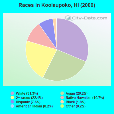
- 36,93531.3%White alone
- 30,90426.2%Asian alone
- 26,09722.1%Two or more races
- 12,56910.7%Native Hawaiian and Other
Pacific Islander alone - 8,9577.6%Hispanic
- 2,0741.8%Black alone
- 2800.2%American Indian alone
- 1780.2%Other race alone
Races in Koolaupoko detailed stats: ancestries, foreign born residents, place of birth
 Recent articles from our blog. Our writers, many of them Ph.D. graduates or candidates, create easy-to-read articles on a wide variety of topics.
Current Local Time: HST (no DST) time zone
Land area: 67.2 square miles.
Population density: 1,804 people per square mile (low).

| Koolaupoko CCD: | 0.3% ($884) |
| Hawaii: | 0.3% ($765) |
Nearest city with pop. 200,000+: Urban Honolulu, HI (7.4 miles  , pop. 337,256).
Nearest city with pop. 1,000,000+: Los Angeles, CA (2547.4 miles , pop. 3,694,820).
Nearest cities:
), ), Latitude: 21.41 N, Longitude: 157.77 W

| Here: | 2.9% |
| Hawaii: | 2.9% |
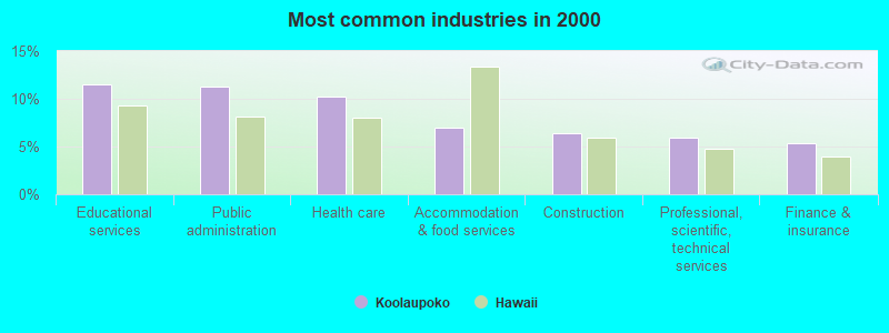
- Educational services (11.5%)
- Public administration (11.2%)
- Health care (10.2%)
- Accommodation & food services (7.0%)
- Construction (6.4%)
- Professional, scientific, technical services (5.9%)
- Finance & insurance (5.3%)
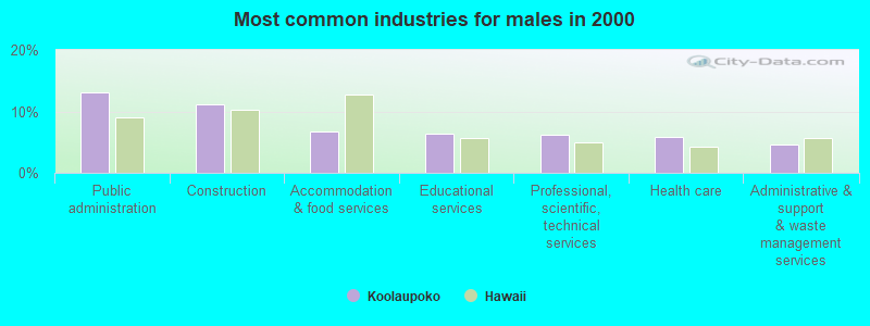
- Public administration (13.1%)
- Construction (11.1%)
- Accommodation & food services (6.7%)
- Educational services (6.4%)
- Professional, scientific, technical services (6.2%)
- Health care (5.9%)
- Administrative & support & waste management services (4.6%)
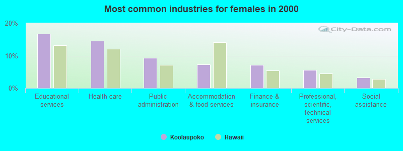
- Educational services (16.7%)
- Health care (14.6%)
- Public administration (9.3%)
- Accommodation & food services (7.2%)
- Finance & insurance (7.2%)
- Professional, scientific, technical services (5.5%)
- Social assistance (3.2%)
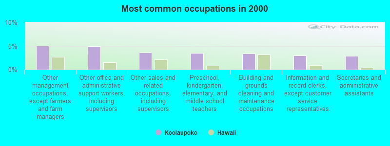
- Other management occupations, except farmers and farm managers (5.1%)
- Other office and administrative support workers, including supervisors (5.0%)
- Other sales and related occupations, including supervisors (3.6%)
- Preschool, kindergarten, elementary, and middle school teachers (3.5%)
- Building and grounds cleaning and maintenance occupations (3.4%)
- Information and record clerks, except customer service representatives (3.0%)
- Secretaries and administrative assistants (2.9%)
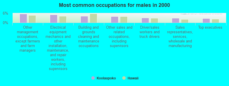
- Other management occupations, except farmers and farm managers (5.7%)
- Electrical equipment mechanics and other installation, maintenance, and repair workers, including supervisors (5.0%)
- Building and grounds cleaning and maintenance occupations (4.1%)
- Other sales and related occupations, including supervisors (3.9%)
- Driver/sales workers and truck drivers (3.2%)
- Sales representatives, services, wholesale and manufacturing (2.9%)
- Top executives (2.8%)
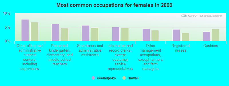
- Other office and administrative support workers, including supervisors (7.8%)
- Preschool, kindergarten, elementary, and middle school teachers (6.2%)
- Secretaries and administrative assistants (5.7%)
- Information and record clerks, except customer service representatives (5.1%)
- Other management occupations, except farmers and farm managers (4.5%)
- Registered nurses (4.2%)
- Cashiers (3.4%)
Average climate in Koolaupoko, Hawaii
Based on data reported by over 4,000 weather stations


(lower is better)
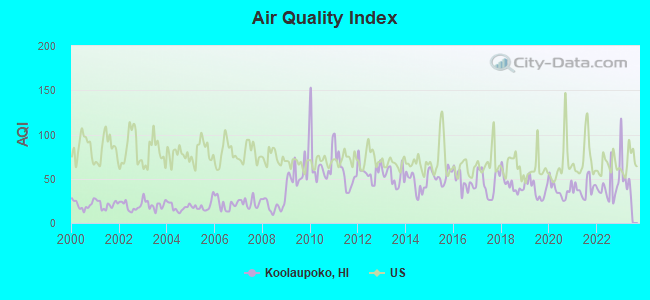
Air Quality Index (AQI) level in 2022 was 39.4. This is significantly better than average.
| City: | 39.4 |
| U.S.: | 72.6 |
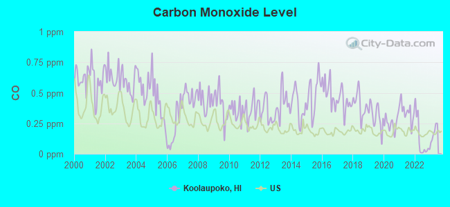
Carbon Monoxide (CO) [ppm] level in 2022 was 0.116. This is significantly better than average. Closest monitor was 8.8 miles away from the city center.
| City: | 0.116 |
| U.S.: | 0.251 |
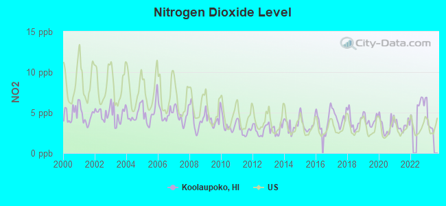
Nitrogen Dioxide (NO2) [ppb] level in 2022 was 5.88. This is about average. Closest monitor was 8.8 miles away from the city center.
| City: | 5.88 |
| U.S.: | 5.11 |
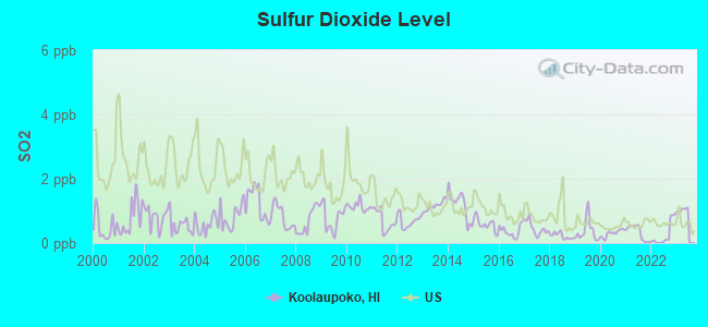
Sulfur Dioxide (SO2) [ppb] level in 2022 was 0.255. This is significantly better than average. Closest monitor was 8.8 miles away from the city center.
| City: | 0.255 |
| U.S.: | 1.515 |
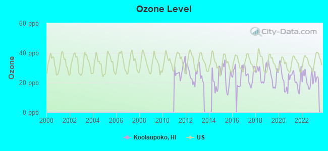
Ozone [ppb] level in 2022 was 22.1. This is significantly better than average. Closest monitor was 8.8 miles away from the city center.
| City: | 22.1 |
| U.S.: | 33.3 |
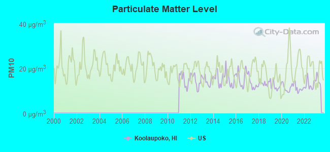
Particulate Matter (PM10) [µg/m3] level in 2022 was 12.7. This is significantly better than average. Closest monitor was 6.4 miles away from the city center.
| City: | 12.7 |
| U.S.: | 19.2 |
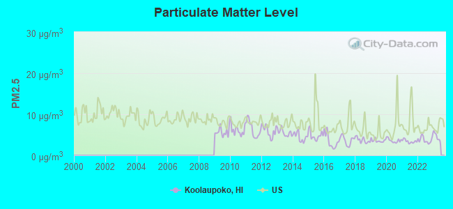
Particulate Matter (PM2.5) [µg/m3] level in 2022 was 3.76. This is significantly better than average. Closest monitor was 8.8 miles away from the city center.
| City: | 3.76 |
| U.S.: | 8.11 |
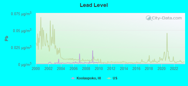
Lead (Pb) [µg/m3] level in 2010 was 0.00154. This is significantly better than average. Closest monitor was 5.1 miles away from the city center.
| City: | 0.00154 |
| U.S.: | 0.00931 |
Earthquake activity:
Koolaupoko-area historical earthquake activity is significantly above Hawaii state average. It is 1149% greater than the overall U.S. average.On 11/29/1975 at 14:47:40, a magnitude 7.2 (6.0 MB, 7.1 MS, 7.2 UK, 7.2 MS, Class: Major, Intensity: VIII - XII) earthquake occurred 223.2 miles away from the city center, causing 2 deaths (2 shaking deaths)
On 8/21/1951 at 10:57:00, a magnitude 6.9 (6.9 UK, Class: Strong, Intensity: VII - IX) earthquake occurred 162.3 miles away from Koolaupoko center
On 10/15/2006 at 17:07:49, a magnitude 6.7 (6.2 MB, 6.6 MS, 6.7 MW) earthquake occurred 157.5 miles away from Koolaupoko center
On 10/15/2006 at 17:07:49, a magnitude 6.7 (6.7 MD, Depth: 23.7 mi) earthquake occurred 159.3 miles away from Koolaupoko center
On 5/4/2018 at 22:32:54, a magnitude 6.9 (6.9 MW, Depth: 3.6 mi) earthquake occurred 230.8 miles away from the city center
On 11/16/1983 at 16:13:00, a magnitude 6.7 (6.4 MB, 6.7 MS, 6.7 MW) earthquake occurred 206.7 miles away from the city center, causing $6,000,000 total damage
Magnitude types: body-wave magnitude (MB), duration magnitude (MD), surface-wave magnitude (MS), moment magnitude (MW)
Natural disasters:
The number of natural disasters in Honolulu County (16) is near the US average (15).Major Disasters (Presidential) Declared: 10
Emergencies Declared: 1
Causes of natural disasters: Floods: 7, Storms: 7, Fires: 3, Mudslides: 3, Landslides: 2, Earthquake: 1, Flash Flood: 1, Heavy Rain: 1, Hurricane: 1, Tsunami Wave: 1, Typhoon: 1, Other: 1 (Note: some incidents may be assigned to more than one category).
Hospitals and medical centers near Koolaupoko:
- LIBERTY DIALYSIS HAWAII KAILUA DIALYSIS FACILITY (Dialysis Facility, about 2 miles away; KAILUA, HI)
- CASTLE MEDICAL CENTER Acute Care Hospitals (about 2 miles away; KAILUA, HI)
- HAWAII STATE HOSP (Hospital, about 3 miles away; KANEOHE, HI)
- ALOHA HEALTH CARE CENTER (Nursing Home, about 6 miles away; KANEOHE, HI)
- ALOHA NURSING AND REHAB CENTRE (Nursing Home, about 6 miles away; KANEOHE, HI)
- ST FRANCIS HOSPICE (Hospital, about 7 miles away; HONOLULU, HI)
- NUUANU HALE (Nursing Home, about 7 miles away; HONOLULU, HI)
Colleges/universities with over 2000 students nearest to Koolaupoko:
- Chaminade University of Honolulu (about 9 miles; Honolulu, HI; Full-time enrollment: 2,610)
- University of Hawaii at Manoa (about 9 miles; Honolulu, HI; FT enrollment: 16,461)
- Hawaii Pacific University (about 9 miles; Honolulu, HI; FT enrollment: 5,506)
- Honolulu Community College (about 10 miles; Honolulu, HI; FT enrollment: 2,538)
- Kapiolani Community College (about 10 miles; Honolulu, HI; FT enrollment: 5,069)
- Leeward Community College (about 14 miles; Pearl City, HI; FT enrollment: 4,589)
- Brigham Young University-Hawaii (about 19 miles; Laie, HI; FT enrollment: 3,527)
Points of interest:
Notable locations in Koolaupoko: Kualoa Ranch (A), Waikāne Camp (B), Kahua Hau (C), Kahua Kuku (D), Kahua Kuou (E), Kahua Lehua (F), Kahua Nui (G), Pa Launa (H), Kāne‘ohe Yacht Club (I), Klipper Golf Course (J), Waimānalo Landing (K), Mid Pacific Country Club (L), Olomana Golf Course (M), Pali Golf Course (N), Waiāhole Camp (O), Ulupō Heiau (P), Camp Kokokahi (Q), Halekipa Camp (R), Kailua Wastewater Treatment Plant (S), Bay View Golf Center (T). Display/hide their locations on the map
Shopping Centers: Temple Valley Shopping Center (1), Windward City Shopping Center (2), Windward Mall Shopping Center (3), Windward Town and Country Plaza Shopping Center (4), Enchanted Lake Shopping Center (5), Aikahi Park Shopping Center (6), Kāne‘ohe Bay Shopping Center (7), Kāne‘ohe Shopping Center (8), Kailua Beach Shopping Center (9). Display/hide their locations on the map
Churches in Koolaupoko include: Windward United Church of Christ (A), Kaneohe Higashi Hongwanji (B), Emmanuel Episcopal Church (C), Waimanalo Seventh Day Adventist Church (D), Calvary Chapel Windward (E), Calvary Church of the Islands (F), Calvary Episcopal Church (G), Church of Christ at Kailua (H), Saint Thomas More Church (I). Display/hide their locations on the map
Cemeteries: Valley of the Temples (1), Hawaiian Memorial Park (2), Our Lady of Mount Carmel Cemetery (3), Waikane Congregational Church Cemetery (4), Heeia Japanese Cemetery (5). Display/hide their locations on the map
Lakes, reservoirs, and swamps: Kaluapuhi Pond (A), Ka‘elepulu Pond (B), Mōli‘i Pond (C), Nu‘upia Pond (D), Halekou Pond (E), Waokele Pond (F), Waikalua-Loko Fish Pond (G), Waihalua Fish Pond (H). Display/hide their locations on the map
Streams, rivers, and creeks: Olomana Stream (A), ‘Ōma‘o Stream (B), Palapū Stream (C), Waianu Stream (D), Uwao Stream (E), Waihe‘e Stream (F), Piho Stream (G), Kawa Stream (H), Makawao Stream (I). Display/hide their locations on the map
Parks in Koolaupoko include: Ho‘omaluhia Park (1), Kawainui Park (2), Heeia Playground (3), Atherton Soccer Field (4), Waimānalo District Park (5), Keolu Hills Playground (6), Kahalu‘u Regional Park (7), Waihee Valley Nature Park (8), Kaneohe Community Park (9). Display/hide their locations on the map
Beaches: Kalama Beach (A), Fort Hase Beach (B), Oneawa Beach (C), North Beach (D), Kailua Beach (E), Kualoa Sugar Mill Beach (F), Kuahine (G). Display/hide their locations on the map
| This place: | 3.1 people |
| Hawaii: | 2.9 people |
| This place: | 78.2% |
| Whole state: | 68.9% |
| This place: | 5.4% |
| Whole state: | 7.3% |
Likely homosexual households (counted as self-reported same-sex unmarried-partner households)
- Lesbian couples: 0.6% of all households
- Gay men: 0.4% of all households
| This place: | 5.7% |
| Whole state: | 10.7% |
| This place: | 2.8% |
| Whole state: | 5.0% |
People in group quarters in Koolaupoko in 2010:
- 2,989 people in military barracks and dormitories (nondisciplinary)
- 460 people in nursing facilities/skilled-nursing facilities
- 313 people in state prisons
- 238 people in other noninstitutional facilities
- 208 people in college/university student housing
- 136 people in residential treatment centers for adults
- 82 people in correctional facilities intended for juveniles
- 59 people in workers' group living quarters and job corps centers
- 39 people in group homes intended for adults
- 16 people in emergency and transitional shelters (with sleeping facilities) for people experiencing homelessness
- 12 people in local jails and other municipal confinement facilities
- 10 people in group homes for juveniles (non-correctional)
People in group quarters in Koolaupoko in 2000:
- 4,256 people in military barracks, etc.
- 240 people in state prisons
- 213 people in job corps and vocational training facilities
- 149 people in college dormitories (includes college quarters off campus)
- 146 people in homes or halfway houses for drug/alcohol abuse
- 141 people in nursing homes
- 140 people in orthopedic wards and institutions for the physically handicapped
- 115 people in other noninstitutional group quarters
- 84 people in training schools for juvenile delinquents
- 52 people in homes for the mentally ill
- 24 people in agriculture workers' dormitories on farms
- 18 people in homes for the mentally retarded
- 12 people in other nonhousehold living situations
- 11 people in halfway houses
- 10 people in mental (psychiatric) hospitals or wards
- 9 people in religious group quarters
- 5 people in hospitals/wards and hospices for chronically ill
- 5 people in hospices or homes for chronically ill
- 2 people in other group homes
For population 15 years and over in Koolaupoko:
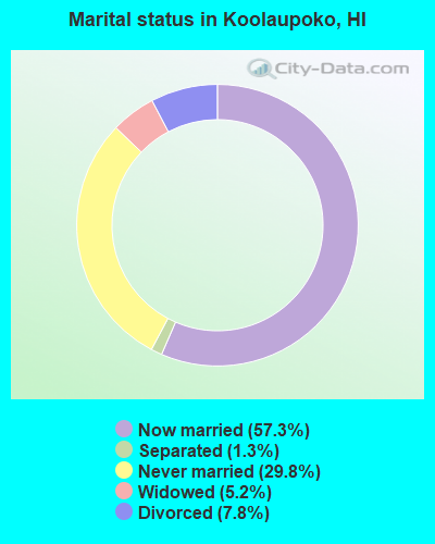
- Never married: 29.8%
- Now married: 57.3%
- Separated: 1.3%
- Widowed: 5.2%
- Divorced: 7.8%
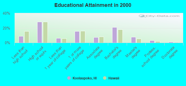
For population 25 years and over in Koolaupoko:
- High school or higher: 90.9%
- Bachelor's degree or higher: 33.1%
- Graduate or professional degree: 12.0%
- Unemployed: 5.6%
- Mean travel time to work (commute): 26.9 minutes
| Here: | 10.9 |
| Hawaii average: | 12.8 |
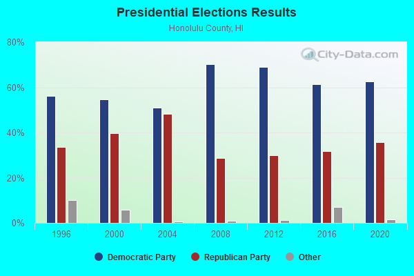
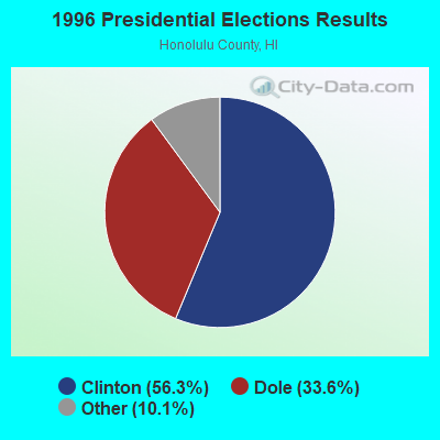
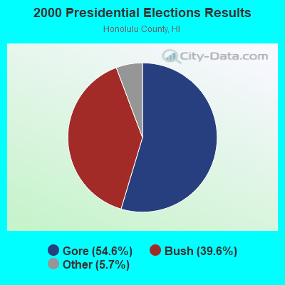
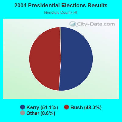
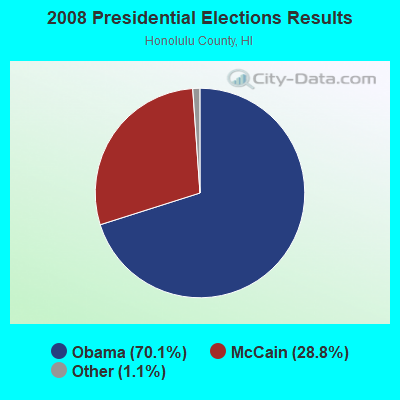
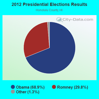
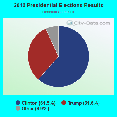
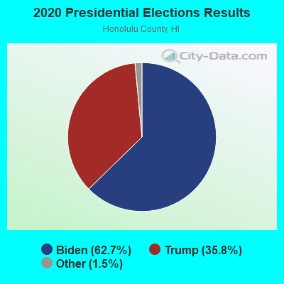
Graphs represent county-level data. Detailed 2008 Election Results
Religion statistics for Koolaupoko, HI (based on Honolulu County data)
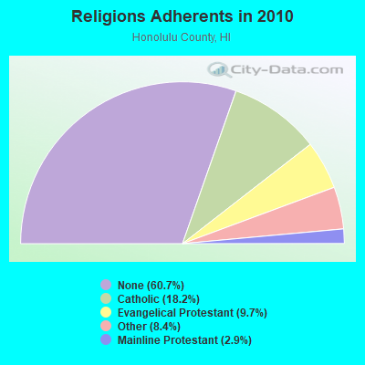
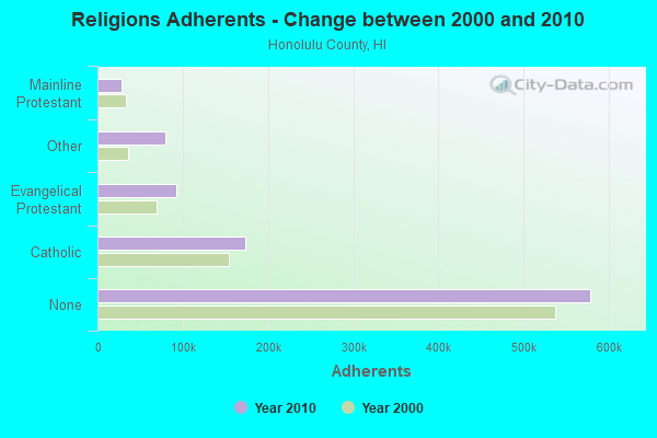
| Religion | Adherents | Congregations |
|---|---|---|
| Catholic | 173,716 | 39 |
| Evangelical Protestant | 92,310 | 382 |
| Other | 80,221 | 204 |
| Mainline Protestant | 28,013 | 115 |
| Orthodox | 300 | 4 |
| None | 578,647 | - |
Food Environment Statistics:
| Honolulu County: | 2.17 / 10,000 pop. |
| State: | 2.30 / 10,000 pop. |
| Honolulu County: | 0.10 / 10,000 pop. |
| Hawaii: | 0.09 / 10,000 pop. |
| This county: | 1.40 / 10,000 pop. |
| State: | 1.57 / 10,000 pop. |
| Honolulu County: | 1.57 / 10,000 pop. |
| State: | 1.72 / 10,000 pop. |
| Honolulu County: | 8.15 / 10,000 pop. |
| Hawaii: | 9.00 / 10,000 pop. |
| Honolulu County: | 8.3% |
| Hawaii: | 8.1% |
| Here: | 20.5% |
| Hawaii: | 20.8% |
| Here: | 8.9% |
| State: | 9.2% |
4.80% of this county's 2021 resident taxpayers lived in other counties in 2020 ($72,704 average adjusted gross income)
| Here: | 4.80% |
| Hawaii average: | 4.91% |
0.27% of residents moved from foreign countries ($4,064 average AGI)
Honolulu County: 0.27% Hawaii average: 0.19%
Top counties from which taxpayers relocated into this county between 2020 and 2021:
| from San Diego County, CA | |
| from Los Angeles County, CA | |
| from Hawaii County, HI |
5.90% of this county's 2020 resident taxpayers moved to other counties in 2021 ($71,643 average adjusted gross income)
| Here: | 5.90% |
| Hawaii average: | 5.53% |
0.21% of residents moved to foreign countries ($2,928 average AGI)
Honolulu County: 0.21% Hawaii average: 0.15%
Top counties to which taxpayers relocated from this county between 2020 and 2021:
| to Clark County, NV | |
| to San Diego County, CA | |
| to Hawaii County, HI |
Strongest AM radio stations in Koolaupoko:
- KSSK (590 AM; 8 kW; HONOLULU, HI; Owner: CAPSTAR TX LIMITED PARTNERSHIP)
- KHVH (830 AM; 10 kW; HONOLULU, HI; Owner: CAPSTAR TX LIMITED PARTNERSHIP)
- KORL (690 AM; 10 kW; HONOLULU, HI; Owner: NEW WAVE BROADCASTING, L.P.)
- KGU (760 AM; 10 kW; HONOLULU, HI; Owner: SALEM MEDIA OF HAWAII, INC.)
- KLHT (1040 AM; 10 kW; HONOLULU, HI; Owner: CALVARY CHAPEL OF HONOLULU, INC.)
- KUMU (1500 AM; 10 kW; HONOLULU, HI; Owner: MAVERICK MEDIA OF OAHU LICENSE LLC)
- KHBZ (990 AM; 5 kW; HONOLULU, HI; Owner: CAPSTAR TX LIMITED PARTNERSHIP)
- KNDI (1270 AM; 5 kW; HONOLULU, HI; Owner: BROADCAST HOUSE OF THE PACIFIC INC.)
- KWAI (1080 AM; 5 kW; HONOLULU, HI; Owner: RADIO HAWAII, INC.)
- KHRA (1460 AM; 5 kW; HONOLULU, HI; Owner: TRADE CENTER MANAGEMENT, INC.)
- KKEA (1420 AM; 5 kW; HONOLULU, HI; Owner: BLOW UP, LLC)
- KHNR (650 AM; 10 kW; HONOLULU, HI; Owner: SALEM MEDIA OF HAWAII, INC.)
- KREA (1540 AM; 5 kW; HONOLULU, HI; Owner: JMK COMMUNICATIONS,INC.)
Strongest FM radio stations in Koolaupoko:
- KXME (104.3 FM; KANEOHE, HI; Owner: CXR HOLDINGS, INC.)
- KRTR-FM (96.3 FM; KAILUA, HI; Owner: CXR HOLDINGS, INC.)
- KHUI (99.5 FM; HONOLULU, HI; Owner: NEW WAVE BROADCASTING, L.P.)
- K215EH (90.9 FM; KAILUA, HI; Owner: CALVARY CHAPEL OF TWIN FALLS, INC.)
- KAIM-FM (95.5 FM; HONOLULU, HI; Owner: SALEM MEDIA OF HAWAII, INC.)
- KAHA (105.9 FM; HONOLULU, HI; Owner: KASA MOKU KA PAWA BROADCASTING, INC.)
- KCCN-FM (100.3 FM; HONOLULU, HI; Owner: CXR HOLDINGS, INC.)
- KGMZ-FM (107.9 FM; AIEA, HI; Owner: HONOLULU BROADCASTING, INC.)
- KINE-FM (105.1 FM; HONOLULU, HI; Owner: CXR HOLDINGS, INC.)
- KUCD (101.9 FM; PEARL CITY, HI; Owner: CAPSTAR TX LIMITED PARTNERSHIP)
- KSSK-FM (92.3 FM; WAIPAHU, HI; Owner: CAPSTAR TX LIMITED PARTNERSHIP)
- KIPO (89.3 FM; HONOLULU, HI; Owner: HAWAII PUBLIC RADIO)
- KDDB (102.7 FM; WAIPAHU, HI; Owner: NEW WAVE BROADCASTING, L.P.)
- KPOI-FM (97.5 FM; HONOLULU, HI; Owner: NEW WAVE BROADCASTING, L.P.)
- KQMQ-FM (93.1 FM; HONOLULU, HI; Owner: NEW WAVE BROADCASTING, L.P.)
- KUMU-FM (94.7 FM; HONOLULU, HI; Owner: MAVERICK MEDIA OF OAHU LICENSE LLC)
- KDNN (98.5 FM; HONOLULU, HI; Owner: CAPSTAR TX LIMITED PARTNERSHIP)
- KTUH (90.3 FM; HONOLULU, HI; Owner: THE UNIVERSITY OF HAWAII)
TV broadcast stations around Koolaupoko:
- K44DQ (Channel 44; KANEOHE, HI; Owner: RAYCOM NATIONAL, INC.)
- KHON-TV (Channel 2; HONOLULU, HI; Owner: EMMIS TELEVISION LICENSE CORPORATION)
- KGMB (Channel 9; HONOLULU, HI; Owner: EMMIS TELEVISION LICENSE CORPORATION)
- KITV (Channel 4; HONOLULU, HI; Owner: KITV HEARST-ARGYLE TV, INC. (CA CORP.))
- KHET (Channel 11; HONOLULU, HI; Owner: HAWAII PUBLIC TELEVISION FOUNDATION)
- KBFD (Channel 32; HONOLULU, HI; Owner: THE ALLEN BROADCASTING CORP.)
- KHNL (Channel 13; HONOLULU, HI; Owner: RAYCOM NATIONAL, INC.)
- K42CO (Channel 42; HONOLULU, HI; Owner: OCEANIA BROADCASTING NETWORK, INC.)
- KPXO (Channel 66; KANEOHE, HI; Owner: PAXSON HAWAII LICENSE, INC.)
- KFVE (Channel 5; HONOLULU, HI; Owner: RAYCOM NATIONAL, INC.)
- KWHE (Channel 14; HONOLULU, HI; Owner: LESEA BROADCASTING CORPORATION)
- KIKU (Channel 20; HONOLULU, HI; Owner: KHLS, INC.)
FCC Registered Antenna Towers:
5- Edward G Roach, 41-708 Kakaina St (Hi41021-T) (Lat: 21.342972 Lon: -157.726556), Type: 27.4, Structure height: 15003 m, Overall height: 25.9 m, Registrant: Sba Monarch Towers Ii, LLC, Eroach@sbasite.Com, , Boca -Raton, Phone: (561) 995-7670
- Edward G Roach, 41-708 Kakaina St (Hi41021-T) (Lat: 21.342972 Lon: -157.726556), Type: 27.4, Structure height: 15003 m, Overall height: 25.9 m, Registrant: Sba Monarch Towers Ii, LLC, Eroach@sbasite.Com, , Boca -Raton, Phone: (561) 995-7670
- Edward G Roach, 41-708 Kakaina St (Hi41021-T) (Lat: 21.342972 Lon: -157.726556), Type: 27.4, Structure height: 15003 m, Overall height: 25.9 m, Registrant: Sba Monarch Towers I, LLC, Eroach@sbasite.Com, , Boca -Raton, Phone: (561) 995-7670
- Edward G Roach, 41-708 Kakaina St (Hi41021-T) (Lat: 21.342861 Lon: -157.726750), Type: 27.4, Structure height: 15003 m, Overall height: 25.9 m, Registrant: Sba Monarch Towers I, LLC, Eroach@sbasite.Com, , Boca -Raton, Phone: (561) 995-7670
- Edward G Roach, 41-708 Kakaina St (Hi41021-T) (Lat: 21.342861 Lon: -157.726750), Type: 27.4, Structure height: 15003 m, Overall height: 25.9 m, Registrant: Sba Monarch Towers I, LLC, Eroach@sbasite.Com, , Boca -Raton, Phone: (561) 995-7670
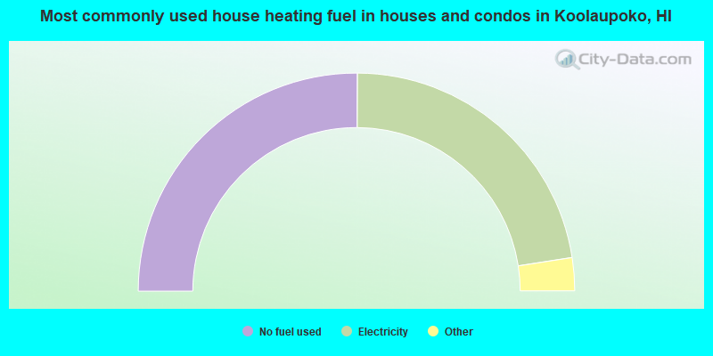
- 50.1%No fuel used
- 44.9%Electricity
- 2.2%Solar energy
- 1.6%Utility gas
- 0.9%Bottled, tank, or LP gas
- 0.1%Wood

- 49.6%No fuel used
- 46.5%Electricity
- 2.2%Utility gas
- 0.9%Bottled, tank, or LP gas
- 0.6%Solar energy
- 0.2%Fuel oil, kerosene, etc.
Koolaupoko compared to Hawaii state average:
- Unemployed percentage below state average.
- Median age below state average.
- Foreign-born population percentage significantly below state average.
- Length of stay since moving in significantly above state average.
- Number of rooms per house significantly below state average.
- House age significantly below state average.
Koolaupoko, HI compared to other similar cities:
Koolaupoko on our top lists:
- #2 on the list of "Top 101 cities with largest percentage of males in occupations: transportation, tourism, and lodging attendants (population 50,000+)"
- #2 on the list of "Top 101 cities with the smallest temperature differences during a year (population 50,000+)"
- #3 on the list of "Top 101 cities with largest percentage of males in industries: private households (population 50,000+)"
- #3 on the list of "Top 101 cities with largest percentage of females in occupations: farmers and farm managers (population 50,000+)"
- #4 on the list of "Top 101 cities with largest percentage of females in industries: air transportation (population 50,000+)"
- #5 on the list of "Top 101 cities with largest percentage of females in occupations: transportation, tourism, and lodging attendants (population 50,000+)"
- #5 on the list of "Top 101 cities with the smallest differences between daily high and daily low temperatures (population 50,000+)"
- #5 on the list of "Top 101 cities with largest percentage of males in occupations: counselors, social workers, and other community and social service specialists (population 50,000+)"
- #6 on the list of "Top 101 cities with largest percentage of males in industries: religious, grantmaking, civic, professional, and similar organizations (population 50,000+)"
- #6 on the list of "Top 101 cities with the largest percentage of high school students in private schools (3,000+ students)"
- #7 on the list of "Top 101 cities with largest percentage of females in occupations: librarians, curators, and archivists (population 50,000+)"
- #7 on the list of "Top 101 cities with largest percentage of females in occupations: information and record clerks except customer service representatives (population 50,000+)"
- #9 on the list of "Top 101 cities with largest percentage of females in industries: motor vehicles, parts and supplies merchant wholesalers (population 50,000+)"
- #9 on the list of "Top 101 cities with largest percentage of females in industries: jewelry, luggage, and leather goods stores (population 50,000+)"
- #10 on the list of "Top 101 cities with largest percentage of males in industries: air transportation (population 50,000+)"
- #14 on the list of "Top 101 cities with largest percentage of males in industries: water transportation (population 50,000+)"
- #15 on the list of "Top 101 cities with largest percentage of males in industries: book stores and news dealers (population 50,000+)"
- #16 on the list of "Top 101 cities with largest percentage of males in industries: pharmacies and drug stores (population 50,000+)"
- #16 on the list of "Top 101 cities with largest percentage of males in industries: sporting goods, camera, and hobby and toy stores (population 50,000+)"
- #18 on the list of "Top 101 cities with largest percentage of females in industries: miscellaneous durable goods merchant wholesalers (population 50,000+)"
- #65 (96744) on the list of "Top 101 zip codes with the largest percentage of Portuguese first ancestries (pop 5,000+)"
- #7 on the list of "Top 101 counties with the lowest average weight of females"
- #15 on the list of "Top 101 counties with the highest ground withdrawal of fresh water for public supply"
- #21 on the list of "Top 101 counties with the most Other congregations"
- #25 on the list of "Top 101 counties with the most Other adherents"
- #25 on the list of "Top 101 counties with the highest carbon monoxide air pollution readings in 2012 (ppm)"