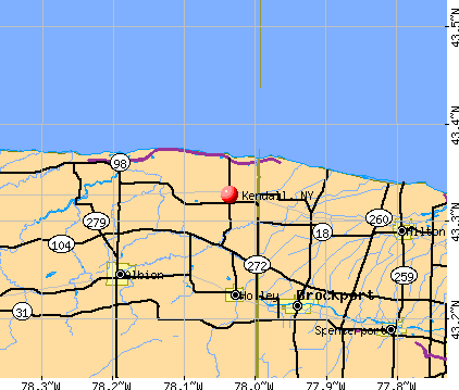
Kendall, New York
Submit your own pictures of this town and show them to the world
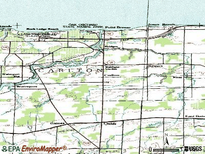
- OSM Map
- General Map
- Google Map
- MSN Map
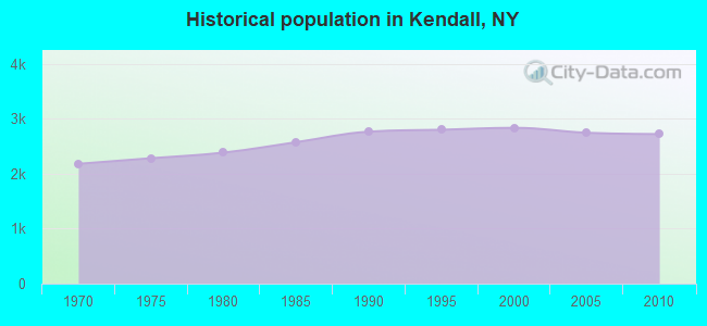
Population change since 2000: -4.0%
 |
| Males: 1,375 | |
| Females: 1,349 |
| Median resident age: | 44.7 years |
| New York median age: | 40.7 years |
Zip codes: 14476.
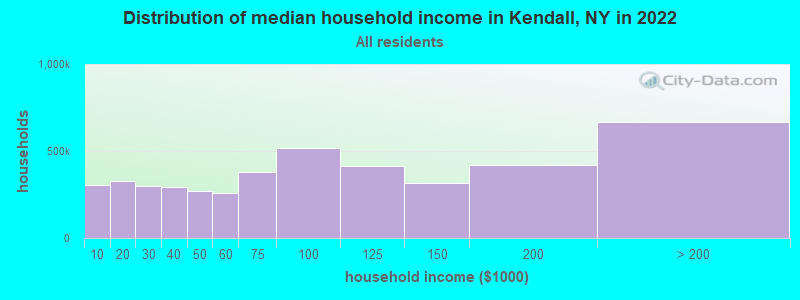
| Kendall: | $78,325 |
| NY: | $79,557 |
Estimated per capita income in 2022: $41,134 (it was $20,373 in 2000)
Kendall town income, earnings, and wages data
Estimated median house or condo value in 2022: $167,575 (it was $93,400 in 2000)
| Kendall: | $167,575 |
| NY: | $400,400 |
Mean prices in 2022: all housing units: $164,365; detached houses: $165,013; townhouses or other attached units: $491,930; in 2-unit structures: $156,438; in 3-to-4-unit structures: $131,294; in 5-or-more-unit structures: $274,444; mobile homes: $57,995
Detailed information about poverty and poor residents in Kendall, NY


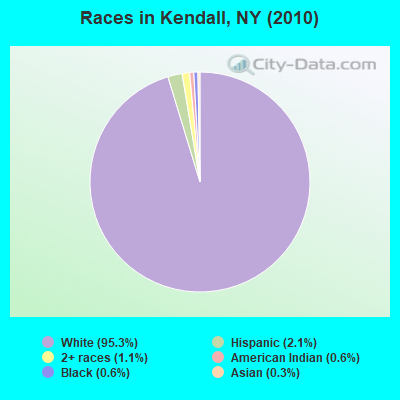
- 2,59695.3%White alone
- 582.1%Hispanic
- 301.1%Two or more races
- 150.6%Black alone
- 170.6%American Indian alone
- 70.3%Asian alone
- 10.04%Native Hawaiian and Other
Pacific Islander alone
Races in Kendall detailed stats: ancestries, foreign born residents, place of birth
According to our research of New York and other state lists, there was 1 registered sex offender living in Kendall, New York as of May 10, 2024.
The ratio of all residents to sex offenders in Kendall is 2,724 to 1.
The ratio of registered sex offenders to all residents in this city is much lower than the state average.
 Recent articles from our blog. Our writers, many of them Ph.D. graduates or candidates, create easy-to-read articles on a wide variety of topics.


Latest news from Kendall, NY collected exclusively by city-data.com from local newspapers, TV, and radio stations
Ancestries: German (31.9%), English (18.5%), Irish (16.9%), Italian (13.2%), Polish (7.0%), United States (6.8%).
Current Local Time: EST time zone
Incorporated in 1835
Elevation: 338 feet
Land area: 32.9 square miles.
Population density: 83 people per square mile (very low).
62 residents are foreign born (0.8% Europe, 0.7% North America, 0.4% Latin America, 0.3% Asia).
| This town: | 2.2% |
| New York: | 20.4% |
| Kendall town: | 2.6% ($2,462) |
| New York: | 1.9% ($2,847) |
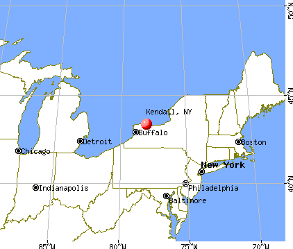
Nearest city with pop. 50,000+: Rochester, NY  (25.0 miles , pop. 219,773).
Nearest city with pop. 1,000,000+: Manhattan, NY (274.4 miles , pop. 1,537,195).
Nearest cities:
), ), ), ), Latitude: 43.34 N, Longitude: 78.05 W
Area code: 585

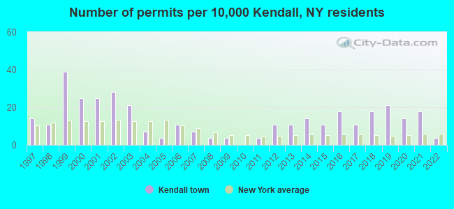
Single-family new house construction building permits:
- 2022: 1 building, cost: $100,000
- 2021: 5 buildings, average cost: $154,000
- 2020: 4 buildings, average cost: $102,500
- 2019: 6 buildings, average cost: $295,300
- 2018: 5 buildings, average cost: $79,600
- 2017: 3 buildings, average cost: $183,300
- 2016: 5 buildings, average cost: $211,900
- 2015: 3 buildings, average cost: $146,700
- 2014: 4 buildings, average cost: $97,500
- 2013: 3 buildings, average cost: $75,000
- 2012: 3 buildings, average cost: $236,600
- 2011: 1 building, cost: $75,000
- 2009: 1 building, cost: $330,000
- 2008: 1 building, cost: $330,000
- 2007: 2 buildings, average cost: $61,700
- 2006: 3 buildings, average cost: $61,700
- 2005: 1 building, cost: $280,000
- 2004: 2 buildings, average cost: $137,500
- 2003: 6 buildings, average cost: $111,200
- 2002: 8 buildings, average cost: $107,600
- 2001: 7 buildings, average cost: $95,200
- 2000: 7 buildings, average cost: $108,000
- 1999: 11 buildings, average cost: $110,700
- 1998: 3 buildings, average cost: $100,300
- 1997: 4 buildings, average cost: $59,300

| Here: | 4.6% |
| New York: | 4.4% |
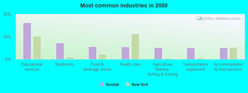
- Educational services (16.3%)
- Machinery (7.3%)
- Food & beverage stores (5.7%)
- Health care (5.5%)
- Agriculture, forestry, fishing & hunting (5.2%)
- Transportation equipment (5.1%)
- Accommodation & food services (5.1%)
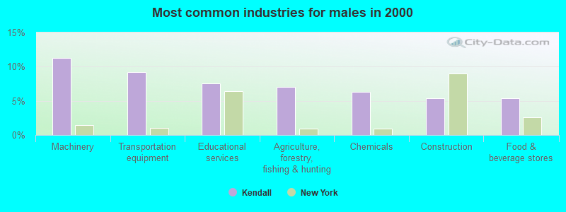
- Machinery (11.3%)
- Transportation equipment (9.2%)
- Educational services (7.5%)
- Agriculture, forestry, fishing & hunting (7.1%)
- Chemicals (6.3%)
- Construction (5.3%)
- Food & beverage stores (5.3%)
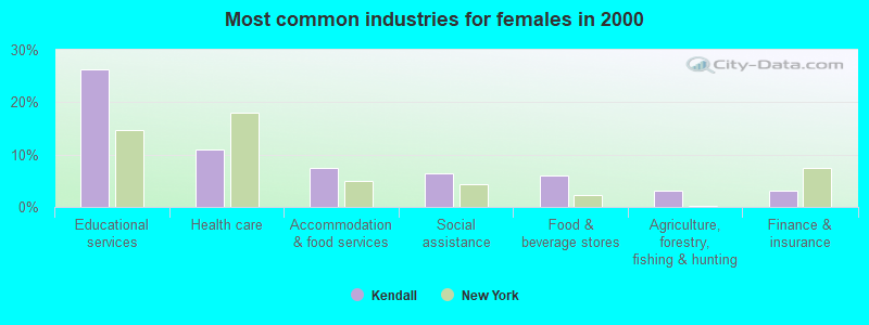
- Educational services (26.2%)
- Health care (11.0%)
- Accommodation & food services (7.5%)
- Social assistance (6.4%)
- Food & beverage stores (6.1%)
- Agriculture, forestry, fishing & hunting (3.1%)
- Finance & insurance (3.1%)

- Preschool, kindergarten, elementary, and middle school teachers (6.1%)
- Other production occupations, including supervisors (6.1%)
- Electrical equipment mechanics and other installation, maintenance, and repair workers, including supervisors (4.6%)
- Secretaries and administrative assistants (4.1%)
- Cashiers (4.0%)
- Material recording, scheduling, dispatching, and distributing workers (3.7%)
- Driver/sales workers and truck drivers (3.5%)
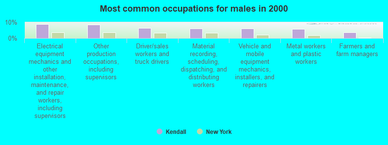
- Electrical equipment mechanics and other installation, maintenance, and repair workers, including supervisors (8.7%)
- Other production occupations, including supervisors (8.4%)
- Driver/sales workers and truck drivers (6.5%)
- Material recording, scheduling, dispatching, and distributing workers (6.2%)
- Vehicle and mobile equipment mechanics, installers, and repairers (6.1%)
- Metal workers and plastic workers (5.6%)
- Farmers and farm managers (3.6%)
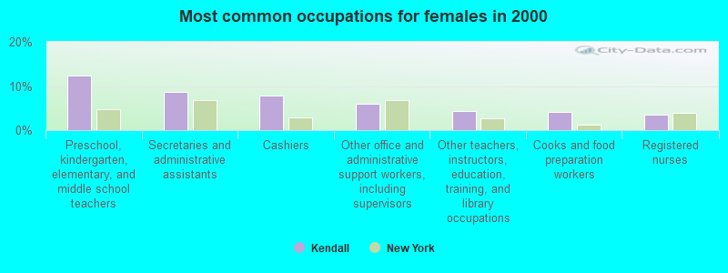
- Preschool, kindergarten, elementary, and middle school teachers (12.3%)
- Secretaries and administrative assistants (8.7%)
- Cashiers (7.9%)
- Other office and administrative support workers, including supervisors (5.9%)
- Other teachers, instructors, education, training, and library occupations (4.4%)
- Cooks and food preparation workers (4.1%)
- Registered nurses (3.6%)
Average climate in Kendall, New York
Based on data reported by over 4,000 weather stations


Earthquake activity:
Kendall-area historical earthquake activity is significantly above New York state average. It is 69% smaller than the overall U.S. average.On 10/7/1983 at 10:18:46, a magnitude 5.3 (5.1 MB, 5.3 LG, 5.1 ML, Class: Moderate, Intensity: VI - VII) earthquake occurred 190.3 miles away from the city center
On 9/25/1998 at 19:52:52, a magnitude 5.2 (4.8 MB, 4.3 MS, 5.2 LG, 4.5 MW, Depth: 3.1 mi) earthquake occurred 175.1 miles away from Kendall center
On 4/20/2002 at 10:50:47, a magnitude 5.3 (5.3 ML, Depth: 3.0 mi) earthquake occurred 231.5 miles away from the city center
On 4/20/2002 at 10:50:47, a magnitude 5.2 (5.2 MB, 4.2 MS, 5.2 MW, 5.0 MW) earthquake occurred 230.0 miles away from Kendall center
On 1/31/1986 at 16:46:43, a magnitude 5.0 (5.0 MB) earthquake occurred 198.9 miles away from the city center
On 8/23/2011 at 17:51:04, a magnitude 5.8 (5.8 MW, Depth: 3.7 mi) earthquake occurred 375.4 miles away from Kendall center
Magnitude types: regional Lg-wave magnitude (LG), body-wave magnitude (MB), local magnitude (ML), surface-wave magnitude (MS), moment magnitude (MW)
Natural disasters:
The number of natural disasters in Orleans County (21) is greater than the US average (15).Major Disasters (Presidential) Declared: 10
Emergencies Declared: 9
Causes of natural disasters: Floods: 5, Snowstorms: 5, Storms: 5, Winter Storms: 5, Hurricanes: 2, Blizzard: 1, Ice Storm: 1, Power Outage: 1, Wind: 1, Other: 2 (Note: some incidents may be assigned to more than one category).
Hospitals and medical centers near Kendall:
- LAKESIDE BEIKIRCH CARE CTR (Nursing Home, about 10 miles away; BROCKPORT, NY)
- LAKESIDE MEMORIAL HOSPITAL (Hospital, about 10 miles away; BROCKPORT, NY)
- ARNOLD GREGORY MEMORIAL HOSPITAL (Hospital, about 10 miles away; ALBION, NY)
- LIFETIME ASSISTANCE, INC (Hospital, about 11 miles away; BROCKPORT, NY)
- HOSPICE OF ORLEANS , INC (Hospital, about 11 miles away; ALBION, NY)
- WEDGEWOOD NURSING HOME (Nursing Home, about 16 miles away; SPENCERPORT, NY)
Airports located in Kendall:
- Maynard's Airport (56NY) (Runways: 1)
Colleges/universities with over 2000 students nearest to Kendall:
- SUNY College at Brockport (about 11 miles; Brockport, NY; Full-time enrollment: 7,398)
- Genesee Community College (about 23 miles; Batavia, NY; FT enrollment: 4,290)
- Rochester Institute of Technology (about 26 miles; Rochester, NY; FT enrollment: 14,177)
- University of Rochester (about 26 miles; Rochester, NY; FT enrollment: 10,201)
- Monroe Community College (about 28 miles; Rochester, NY; FT enrollment: 14,295)
- Saint John Fisher College (about 31 miles; Rochester, NY; FT enrollment: 3,373)
- Nazareth College (about 32 miles; Rochester, NY; FT enrollment: 2,632)
Public high school in Kendall:
- KENDALL JUNIOR-SENIOR HIGH SCHOOL (Students: 426, Location: 16887 ROOSEVELT HWY, Grades: 7-12)
Public elementary/middle school in Kendall:
- KENDALL ELEMENTARY SCHOOL (Students: 408, Location: 1932 KENDALL RD, Grades: PK-6)
Points of interest:
Notable locations in Kendall: Bald Eagle Marina (A), Heberle Farms (B), Partyka Farms (C), Oak Orchard Beach (D), Locust Grove Farm (E), Zingler Farms (F), Billings Farms (G), Radtke Farms (H), Sample Farm (I), Kludt Farms (J), Kendall Fire Department (K). Display/hide their locations on the map
Churches in Kendall include: Concordia Lutheran Church (A), Mount Olive Missionary Baptist Church (B), Saint Mark's Roman Catholic Church (C). Display/hide their locations on the map
Cemeteries: Beachwood Cemetery (1), Morton Union Cemetery (2), Greenwood Cemetery (3). Display/hide their locations on the map
Creek: Bald Eagle Creek (A). Display/hide its location on the map
Birthplace of: Christopher C. Augur - Union Army General.
| This town: | 2.6 people |
| New York: | 2.6 people |
| This town: | 78.2% |
| Whole state: | 63.5% |
| This town: | 7.3% |
| Whole state: | 6.8% |
Likely homosexual households (counted as self-reported same-sex unmarried-partner households)
- Lesbian couples: 0.5% of all households
- Gay men: 0.1% of all households
| This town: | 5.0% |
| Whole state: | 14.6% |
| This town: | 2.3% |
| Whole state: | 7.4% |
For population 15 years and over in Kendall:
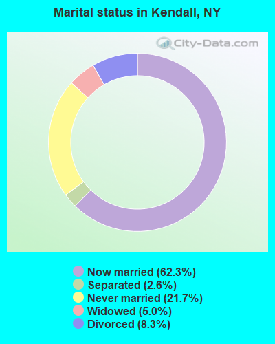
- Never married: 21.7%
- Now married: 62.3%
- Separated: 2.6%
- Widowed: 5.0%
- Divorced: 8.3%
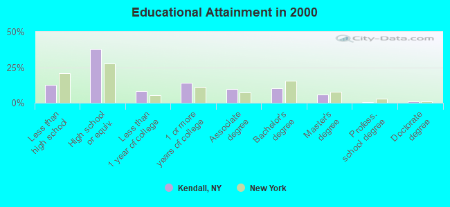
For population 25 years and over in Kendall:
- High school or higher: 87.3%
- Bachelor's degree or higher: 17.4%
- Graduate or professional degree: 7.3%
- Unemployed: 6.2%
- Mean travel time to work (commute): 31.1 minutes
| Here: | 9.9 |
| New York average: | 14.2 |
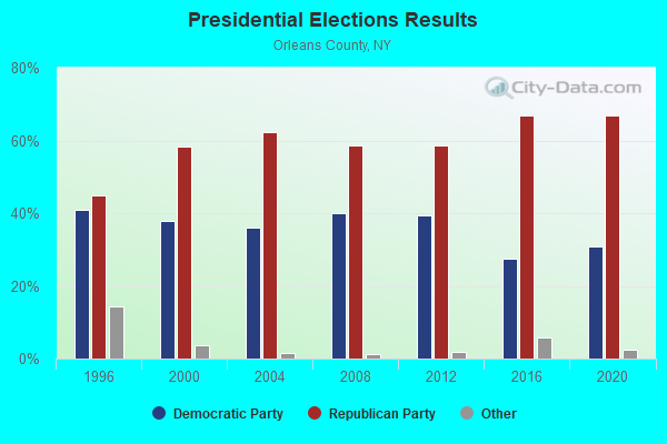
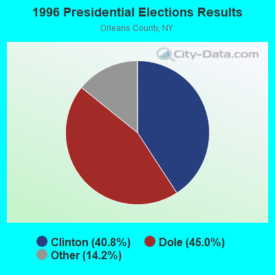
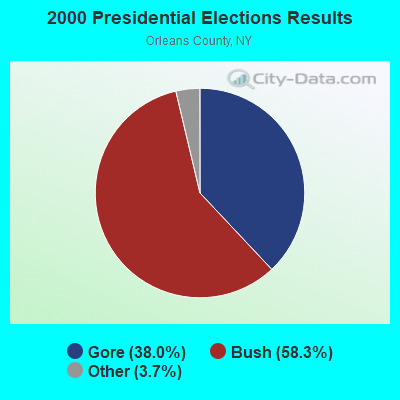
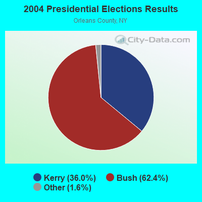
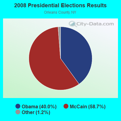
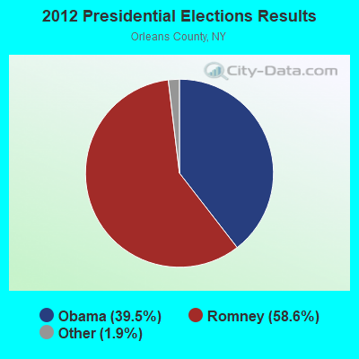
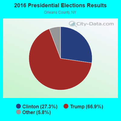
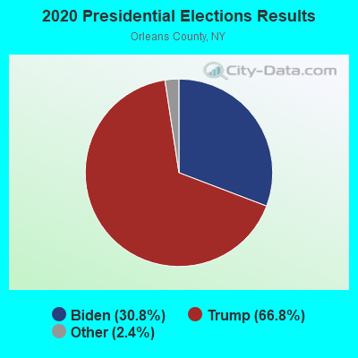
Graphs represent county-level data. Detailed 2008 Election Results
Religion statistics for Kendall, NY (based on Orleans County data)
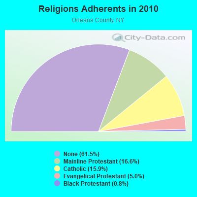
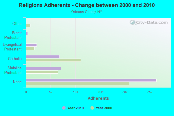
| Religion | Adherents | Congregations |
|---|---|---|
| Mainline Protestant | 7,118 | 27 |
| Catholic | 6,819 | 4 |
| Evangelical Protestant | 2,163 | 21 |
| Black Protestant | 359 | 3 |
| Other | 32 | 2 |
| None | 26,392 | - |
Food Environment Statistics:
| Here: | 2.13 / 10,000 pop. |
| New York: | 4.13 / 10,000 pop. |
| Orleans County: | 4.73 / 10,000 pop. |
| New York: | 1.68 / 10,000 pop. |
| Here: | 5.20 / 10,000 pop. |
| State: | 8.82 / 10,000 pop. |
| Orleans County: | 9.5% |
| New York: | 8.2% |
| Orleans County: | 26.2% |
| State: | 23.8% |
| This county: | 17.5% |
| State: | 15.6% |
Strongest AM radio stations in Kendall:
- WHAM (1180 AM; 50 kW; ROCHESTER, NY; Owner: CITICASTERS LICENSES, L.P.)
- WLGZ (990 AM; 5 kW; ROCHESTER, NY; Owner: KIMTRON, INC.)
- WWKB (1520 AM; 50 kW; BUFFALO, NY; Owner: ENTERCOM BUFFALO LICENSE, LLC)
- WASB (1590 AM; 1 kW; BROCKPORT, NY; Owner: DAVID L. WOLFE)
- WTOR (770 AM; daytime; 9 kW; YOUNGSTOWN, NY; Owner: BIRACH BROADCASTING CORPORATION)
- WHTK (1280 AM; 5 kW; ROCHESTER, NY)
- WXXI (1370 AM; 5 kW; ROCHESTER, NY; Owner: WXXI PUBLIC BROADCASTING COUNCIL)
- WHIC (1460 AM; 5 kW; ROCHESTER, NY; Owner: HOLY FAMILY COMMUNICATIONS)
- WGR (550 AM; 5 kW; BUFFALO, NY; Owner: ENTERCOM BUFFALO LICENSE, LLC)
- WXRL (1300 AM; 5 kW; LANCASTER, NY; Owner: DOME BROADCASTING, INC.)
- WBEN (930 AM; 5 kW; BUFFALO, NY; Owner: ENTERCOM BUFFALO LICENSE, LLC)
- WYSL (1040 AM; 2 kW; AVON, NY; Owner: RADIO LIVINGSTON, LTD)
- WNED (970 AM; 5 kW; BUFFALO, NY)
Strongest FM radio stations in Kendall:
- WJCA (102.1 FM; ALBION, NY; Owner: CSN INTERNATIONAL)
- WMJQ (105.5 FM; BROCKPORT, NY; Owner: CANANDAIGUA BROADCASTING, INC.)
- WRMM-FM (101.3 FM; ROCHESTER, NY; Owner: INFINITY RADIO OPERATIONS INC.)
- WBZA (98.9 FM; ROCHESTER, NY; Owner: ENTERCOM ROCHESTER LICENSE, LLC.)
- WBSU (89.1 FM; BROCKPORT, NY; Owner: STATE UNIVERSITY OF NEW YORK)
- WDCZ-FM (102.7 FM; WEBSTER, NY; Owner: KIMTRON, INC.)
- WDKX (103.9 FM; ROCHESTER, NY; Owner: MONROE COUNTY BROADCASTING CO., LTD.)
- WCMF-FM (96.5 FM; ROCHESTER, NY; Owner: INFINITY RADIO OPERATIONS INC.)
- WXXI-FM (91.5 FM; ROCHESTER, NY; Owner: WXXI PUBLIC BROADCASTING COUNCIL)
- WBEE-FM (92.5 FM; ROCHESTER, NY; Owner: ENTERCOM ROCHESTER LICENSE, LLC.)
- W238AB (95.5 FM; ROCHESTER, NY; Owner: CITICASTERS LICENSES, L.P.)
- WZNE (94.1 FM; BRIGHTON, NY; Owner: INFINITY RADIO OPERATIONS INC.)
- WPXY-FM (97.9 FM; ROCHESTER, NY; Owner: INFINITY RADIO OPERATIONS INC.)
- WKGS (106.7 FM; IRONDEQUOIT, NY; Owner: CITICASTERS LICENSES, L.P.)
- WRUR-FM (88.5 FM; ROCHESTER, NY; Owner: UNIVERSITY OF ROCHESTER B/CAST CORP.)
TV broadcast stations around Kendall:
- WPXJ-TV (Channel 51; BATAVIA, NY; Owner: PAXSON BUFFALO LICENSE, INC.)
- WNYO-TV (Channel 49; BUFFALO, NY; Owner: NEW YORK TELEVISION, INC.)
- WBXO-LP (Channel 15; ROCHESTER, NY; Owner: METRO TV, INC.)
- National Bridge Inventory (NBI) Statistics
- 26Number of bridges
- 184ft / 56.1mTotal length
- $32,450,000Total costs
- 13,782Total average daily traffic
- 539Total average daily truck traffic
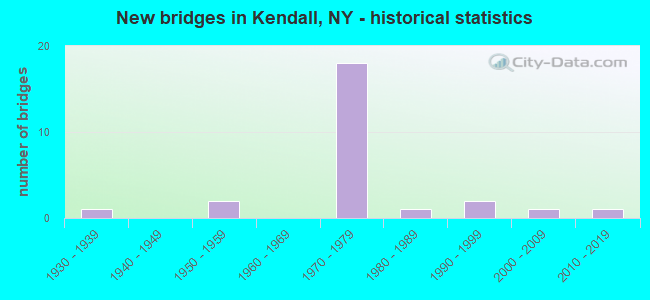
- New bridges - historical statistics
- 11930-1939
- 21950-1959
- 181970-1979
- 11980-1989
- 21990-1999
- 12000-2009
- 12010-2019
FCC Registered Cell Phone Towers:
1 (See the full list of FCC Registered Cell Phone Towers in Kendall)FCC Registered Antenna Towers:
7 (See the full list of FCC Registered Antenna Towers)FCC Registered Broadcast Land Mobile Towers:
1- Fire Dept 879 Main St (Lat: 43.324222 Lon: -78.036139), Call Sign: KQS741,
Assigned Frequencies: 46.0800 MHz, Grant Date: 11/10/2015, Expiration Date: 11/14/2025, Registrant: Orleans County Emergency Management, 14064 W. County House Road, Albion, NY 14411, Phone: (585) 589-4414, Fax: (589) 585-7671, Email:
FCC Registered Microwave Towers:
3- UNY0208, West Kendall Road (Lat: 43.330167 Lon: -78.071028), Type: Ltower, Structure height: 76.2 m, Overall height: 79.2 m, Call Sign: WQUN673,
Assigned Frequencies: 6063.80 MHz, 6093.45 MHz, 6063.80 MHz, 6093.45 MHz, 6063.80 MHz, 6093.45 MHz, 6063.80 MHz, 6093.45 MHz, 6063.80 MHz, 6093.45 MHz... (+6 more), Grant Date: 08/26/2014, Expiration Date: 08/26/2024, Certifier: Ed Delong, Registrant: Uniti Fiber LLC, 107 St. Francis Street, Suite 1800, Mobile, AL 36602, Phone: (877) 652-2321, Email:
- KENDALL, 1932 Kendall Road (Lat: 43.320444 Lon: -78.032861), Type: Ltower, Structure height: 54.9 m, Call Sign: WRFI246, Licensee ID: L00074406,
Assigned Frequencies: 11405.0 MHz, 6315.84 MHz, Grant Date: 03/06/2020, Expiration Date: 03/06/2030, Certifier: Dale Banker, Registrant: County Of Orleans, West County House Road, Albion, NY 14411, Phone: (585) 589-5527, Email:
- Kendall, Tower In Kendall (Lat: 43.320444 Lon: -78.032861), Type: Ltower, Structure height: 45.7 m, Call Sign: WRWS424,
Assigned Frequencies: 11645.0 MHz, 11645.0 MHz, 11645.0 MHz, 11645.0 MHz, 11645.0 MHz, 11645.0 MHz, 11645.0 MHz, 11645.0 MHz, 11645.0 MHz, 11645.0 MHz... (+14 more), Grant Date: 03/22/2023, Expiration Date: 03/22/2033, Certifier: Steve Hubbard, Registrant: Intelpath, Hinsdale, IL 60522, Phone: (312) 841-9188, Email:
FCC Registered Maritime Coast & Aviation Ground Towers:
1- 1033 Lakeland Beach Rd (Lat: 43.339500 Lon: -78.033083), Type: Building, Overall height: 4 m, Call Sign: WHD502, Licensee ID: L00004401,
Assigned Frequencies: 156.450 MHz, 156.800 MHz, 156.900 MHz, Grant Date: 08/01/1994, Expiration Date: 08/01/1999, Cancellation Date: 05/06/2001, Registrant: Eagle Creek Marina, 1033 Lakeland Beach Rd, Kendall, NY 14476
FCC Registered Amateur Radio Licenses:
17 (See the full list of FCC Registered Amateur Radio Licenses in Kendall)FAA Registered Aircraft:
5- Aircraft: CESSNA 150H (Category: Land, Seats: 2, Weight: Up to 12,499 Pounds, Speed: 90 mph), Engine: CONT MOTOR 0-200 SERIES (100 HP) (Reciprocating)
N-Number: 22814, N22814, N-22814, Serial Number: 15068535, Year manufactured: 1968, Airworthiness Date: 03/15/1968, Certificate Issue Date: 11/12/2002
Registrant (Individual): Warren S Kruger, 16751 Smith Dr, Kendall, NY 14476 - Aircraft: AMERICAN CHAMPION AIRCRAFT 7GCBC (Category: Land, Seats: 2, Weight: Up to 12,499 Pounds), Engine: LYCOMING 0-320 SERIES (180 HP) (Reciprocating)
N-Number: 397AC, N397AC, N-397AC, Serial Number: 1244-98, Year manufactured: 1998, Airworthiness Date: 07/08/1998, Certificate Issue Date: 11/18/2010
Registrant (Co-Owned): Jared M Maynard, 16562 Kenmore Rd, Kendall, NY 14476, Other Owners: Mark L Maynard - Aircraft: CHAMPION AERONCA 7BCM (Category: Land, Seats: 2, Weight: Up to 12,499 Pounds, Speed: 90 mph), Engine: CONT MOTOR C85 SERIES (85 HP) (Reciprocating)
N-Number: 83361, N83361, N-83361, Serial Number: 7AC-2028, Year manufactured: 1946, Airworthiness Date: 12/14/1955, Certificate Issue Date: 08/27/1999
Registrant (Co-Owned): Mark L Maynard, 16562 Kenmore Rd, Kendall, NY 14476, Other Owners: Jared M Maynard - Aircraft: PIPER PA-28-140 (Category: Land, Seats: 4, Weight: Up to 12,499 Pounds, Speed: 107 mph), Engine: LYCOMING 0-320 SERIES (180 HP) (Reciprocating)
N-Number: 6864W, N6864W, N-6864W, Serial Number: 28-21020, Year manufactured: 1965, Airworthiness Date: 07/29/1965, Certificate Issue Date: 10/20/2011
Registrant (Individual): Paul D Gray, 1734 Norway Rd, Kendall, NY 14476
Deregistered: Cancel Date: 01/08/2018 - Aircraft: PIPER PA-28-140 (Category: Land, Seats: 4, Weight: Up to 12,499 Pounds, Speed: 107 mph), Engine: LYCOMING 0-320 SERIES (180 HP) (Reciprocating)
N-Number: 6868W, N6868W, N-6868W, Serial Number: 28-21024, Year manufactured: 1965, Airworthiness Date: 08/02/1965, Certificate Issue Date: 06/20/1986
Registrant (Individual): Paul D Gray, 1734 Norway Rd, Kendall, NY 14476
Deregistered: Cancel Date: 01/08/2018
2002 - 2018 National Fire Incident Reporting System (NFIRS) incidents
- Fire incident types reported to NFIRS in Kendall, NY
- 10963.7%Structure Fires
- 4626.9%Outside Fires
- 95.3%Mobile Property/Vehicle Fires
- 74.1%Other
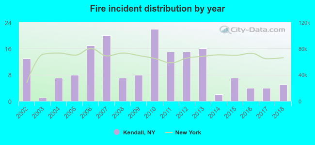 According to the data from the years 2002 - 2018 the average number of fires per year is 10. The highest number of fire incidents - 22 took place in 2010, and the least - 1 in 2003. The data has a dropping trend.
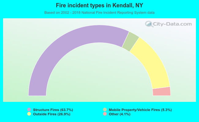 When looking into fire subcategories, the most reports belonged to: Structure Fires (63.7%), and Outside Fires (26.9%).
| Most common first names in Kendall, NY among deceased individuals | ||
| Name | Count | Lived (average) |
|---|---|---|
| William | 11 | 76.9 years |
| John | 11 | 75.8 years |
| Charles | 10 | 71.2 years |
| George | 8 | 79.9 years |
| Robert | 8 | 74.0 years |
| Mary | 7 | 83.7 years |
| Arthur | 6 | 79.8 years |
| Alice | 6 | 74.2 years |
| Laura | 6 | 75.0 years |
| Walter | 6 | 80.0 years |
| Most common last names in Kendall, NY among deceased individuals | ||
| Last name | Count | Lived (average) |
|---|---|---|
| Jurhs | 6 | 76.7 years |
| Wilson | 6 | 61.8 years |
| Butler | 5 | 82.8 years |
| Jurs | 4 | 77.8 years |
| Hall | 4 | 66.8 years |
| Baker | 4 | 57.8 years |
| Mayes | 4 | 84.2 years |
| Smith | 4 | 71.5 years |
| Steffen | 4 | 83.7 years |
| Tomaschke | 4 | 82.0 years |
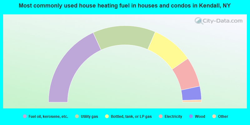
- 36.3%Fuel oil, kerosene, etc.
- 26.6%Utility gas
- 17.7%Bottled, tank, or LP gas
- 12.6%Electricity
- 5.7%Wood
- 0.6%Solar energy
- 0.5%Other fuel
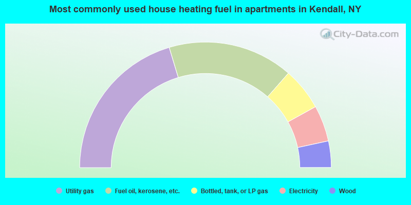
- 40.7%Utility gas
- 32.2%Fuel oil, kerosene, etc.
- 11.0%Bottled, tank, or LP gas
- 9.3%Electricity
- 6.8%Wood
Kendall compared to New York state average:
- Median house value significantly below state average.
- Unemployed percentage below state average.
- Black race population percentage significantly below state average.
- Hispanic race population percentage significantly below state average.
- Foreign-born population percentage significantly below state average.
- Renting percentage significantly below state average.
- Length of stay since moving in significantly above state average.
- Number of rooms per house significantly below state average.
- House age significantly below state average.
- Number of college students below state average.
- Percentage of population with a bachelor's degree or higher below state average.

|
|
Total of 17 patent applications in 2008-2024.