Jamestown, Oklahoma
Submit your own pictures of this town and show them to the world
- OSM Map
- General Map
- Google Map
- MSN Map

| Males: 6 | |
| Females: 5 |
| Median resident age: | 52.5 years |
| Oklahoma median age: | 35.5 years |
Zip code: 74080
| Jamestown: | $88,147 |
| OK: | $59,673 |
Estimated per capita income in 2022: $61,985 (it was $33,007 in 2000)
Estimated median house or condo value in 2022: $467,584 (it was $175,000 in 2000)
| Jamestown: | $467,584 |
| OK: | $191,700 |


- 660.0%White alone
- 440.0%Two or more races

 Recent articles from our blog. Our writers, many of them Ph.D. graduates or candidates, create easy-to-read articles on a wide variety of topics.

 | NYC to OKC - Potential move (34 replies) |
| Feedback please? High crime near 15 & Harvard/Jamestown area (Sunsrise Terrace)? (3 replies) |
| Possible move from Cali (123 replies) |
| PLEASE, need some apartment help as soon as possible (16 replies) |
| Need an apartment quick! (1 reply) |
Latest news from Jamestown, OK collected exclusively by city-data.com from local newspapers, TV, and radio stations
Ancestries: English (100.0%), Scottish (90.0%), Scotch-Irish (20.0%).
Current Local Time: CST time zone
Elevation: 700 feet
Land area: 0.15 square miles.
Population density: 75 people per square mile (very low).

| Jamestown town: | 0.7% ($1,250) |
| Oklahoma: | 0.8% ($523) |
Nearest city with pop. 50,000+: Tulsa, OK  (34.9 miles , pop. 393,049).
Nearest city with pop. 1,000,000+: Dallas, TX (269.0 miles , pop. 1,188,580).
Nearest cities:
), ), ), ), Latitude: 36.57 N, Longitude: 95.63 W
Area code commonly used in this area: 918


| Here: | 3.0% |
| Oklahoma: | 3.2% |
Average climate in Jamestown, Oklahoma
Based on data reported by over 4,000 weather stations


(lower is better)

Air Quality Index (AQI) level in 2023 was 81.1. This is about average.
| City: | 81.1 |
| U.S.: | 72.6 |

Ozone [ppb] level in 2023 was 36.3. This is about average. Closest monitor was 16.4 miles away from the city center.
| City: | 36.3 |
| U.S.: | 33.3 |

Particulate Matter (PM2.5) [µg/m3] level in 2023 was 12.0. This is significantly worse than average. Closest monitor was 24.1 miles away from the city center.
| City: | 12.0 |
| U.S.: | 8.1 |
Tornado activity:
Jamestown-area historical tornado activity is near Oklahoma state average. It is 148% greater than the overall U.S. average.
On 4/26/1991, a category F4 (max. wind speeds 207-260 mph) tornado 6.3 miles away from the Jamestown town center injured 22 people and caused between $5,000,000 and $50,000,000 in damages.
On 4/26/1991, a category F4 tornado 24.5 miles away from the town center killed one person and injured 24 people and caused between $500,000 and $5,000,000 in damages.
Earthquake activity:
Jamestown-area historical earthquake activity is significantly above Oklahoma state average. It is 770% greater than the overall U.S. average.On 9/3/2016 at 12:02:44, a magnitude 5.8 (5.8 MW, Depth: 3.5 mi, Class: Moderate, Intensity: VI - VII) earthquake occurred 73.0 miles away from the city center
On 11/6/2011 at 03:53:10, a magnitude 5.7 (5.7 MW, Depth: 3.2 mi) earthquake occurred 95.9 miles away from Jamestown center
On 11/7/2016 at 01:44:24, a magnitude 5.0 (5.0 MW, Depth: 2.8 mi) earthquake occurred 76.7 miles away from Jamestown center
On 11/5/2011 at 07:12:45, a magnitude 4.8 (4.8 MW, Depth: 1.9 mi, Class: Light, Intensity: IV - V) earthquake occurred 94.9 miles away from the city center
On 11/8/2011 at 02:46:57, a magnitude 4.8 (4.8 MW, Depth: 3.1 mi) earthquake occurred 96.8 miles away from the city center
On 11/12/2014 at 21:40:00, a magnitude 4.9 (4.9 MW, Depth: 2.5 mi) earthquake occurred 120.3 miles away from the city center
Magnitude types: moment magnitude (MW)
Natural disasters:
The number of natural disasters in Rogers County (25) is a lot greater than the US average (15).Major Disasters (Presidential) Declared: 17
Emergencies Declared: 5
Causes of natural disasters: Floods: 11, Storms: 11, Winter Storms: 10, Tornadoes: 7, Winds: 2, Heavy Rain: 1, Hurricane: 1, Ice Storm: 1, Snowstorm: 1, Other: 1 (Note: some incidents may be assigned to more than one category).

Hospitals and medical centers near Jamestown:
- NOWATA NURSING CENTER (Nursing Home, about 9 miles away; NOWATA, OK)
- JANE PHILLIPS NOWATA HEALTH CENTER Critical Access Hospitals (about 9 miles away; NOWATA, OK)
- HAYS HOUSE NURSING HOME (Nursing Home, about 9 miles away; NOWATA, OK)
- OSAGE NURSING HOME, LLC (Nursing Home, about 9 miles away; NOWATA, OK)
- ROBISON HOMECARE, INC (Home Health Center, about 10 miles away; OOLOGAH, OK)
- WOOD MANOR NURSING CENTER (Nursing Home, about 11 miles away; CLAREMORE, OK)
- COLONIAL CARE CENTER (Nursing Home, about 11 miles away; CHELSEA, OK)
Colleges/universities with over 2000 students nearest to Jamestown:
- Rogers State University (about 18 miles; Claremore, OK; Full-time enrollment: 3,482)
- University of Tulsa (about 34 miles; Tulsa, OK; FT enrollment: 3,702)
- Tulsa Community College (about 36 miles; Tulsa, OK; FT enrollment: 12,480)
- Oral Roberts University (about 41 miles; Tulsa, OK; FT enrollment: 3,216)
- Northeastern Oklahoma A&M College (about 48 miles; Miami, OK; FT enrollment: 2,075)
- Northeastern State University (about 59 miles; Tahlequah, OK; FT enrollment: 6,895)
- John Brown University (about 66 miles; Siloam Springs, AR; FT enrollment: 2,097)
Points of interest:
| This town: | 2.5 people |
| Oklahoma: | 2.5 people |
| This town: | 75.0% |
| Whole state: | 69.1% |
| This town: | 0.0% |
| Whole state: | 4.0% |
No gay or lesbian households reported
For population 15 years and over in Jamestown:

- Never married: 40.0%
- Now married: 60.0%
- Separated: 0.0%
- Widowed: 0.0%
- Divorced: 0.0%
For population 25 years and over in Jamestown:
- High school or higher: 100.0%
- Bachelor's degree or higher: 0.0%
- Graduate or professional degree: 0.0%
- Mean travel time to work (commute): 28.8 minutes


| Here: | 1.8 |
| Oklahoma average: | 11.7 |
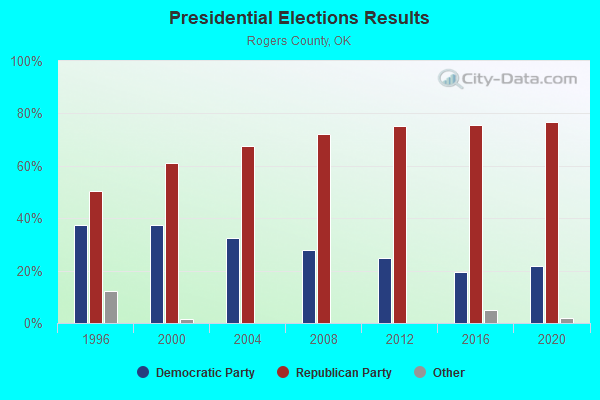
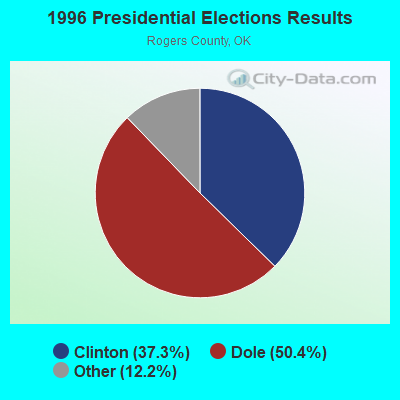

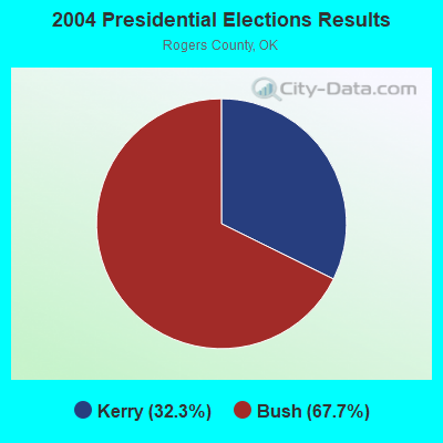
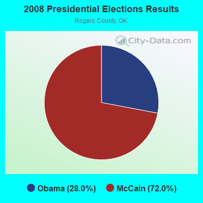
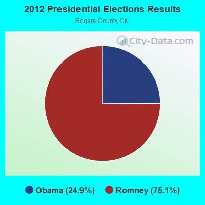
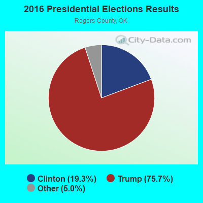
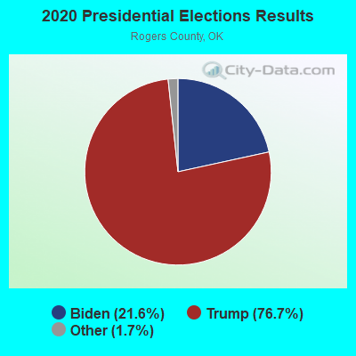
Graphs represent county-level data. Detailed 2008 Election Results
Religion statistics for Jamestown, OK (based on Rogers County data)
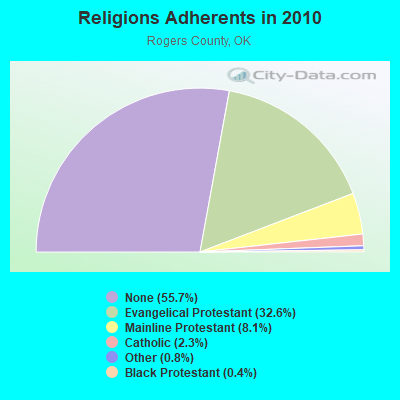
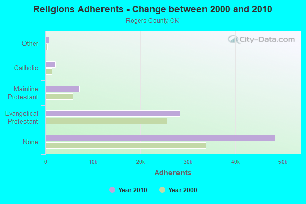
| Religion | Adherents | Congregations |
|---|---|---|
| Evangelical Protestant | 28,301 | 95 |
| Mainline Protestant | 7,079 | 14 |
| Catholic | 2,000 | 1 |
| Other | 714 | 3 |
| Black Protestant | 374 | 3 |
| None | 48,437 | - |
Food Environment Statistics:
| This county: | 0.84 / 10,000 pop. |
| Oklahoma: | 1.97 / 10,000 pop. |
| This county: | 0.12 / 10,000 pop. |
| Oklahoma: | 0.20 / 10,000 pop. |
| This county: | 0.60 / 10,000 pop. |
| Oklahoma: | 0.76 / 10,000 pop. |
| Here: | 2.89 / 10,000 pop. |
| Oklahoma: | 4.35 / 10,000 pop. |
| This county: | 4.70 / 10,000 pop. |
| Oklahoma: | 6.89 / 10,000 pop. |
| Here: | 10.8% |
| State: | 10.3% |
| This county: | 32.3% |
| State: | 29.2% |
Strongest AM radio stations in Jamestown:
- KFAQ (1170 AM; 50 kW; TULSA, OK; Owner: JOURNAL BROADCAST CORPORATION)
- KRMG (740 AM; 50 kW; TULSA, OK; Owner: CXR HOLDINGS, INC.)
- KTBZ (1430 AM; 25 kW; TULSA, OK; Owner: CLEAR CHANNEL BROADCASTING LICENSES, INC.)
- KMUS (1380 AM; 20 kW; MUSKOGEE, OK; Owner: ABC, INC.)
- KGGF (690 AM; 10 kW; COFFEYVILLE, KS; Owner: KGGF-KUSN, INC.)
- KRVT (1270 AM; 1 kW; CLAREMORE, OK; Owner: REUNION BROADCASTING, L.L.C.)
- KAKC (1300 AM; 5 kW; TULSA, OK; Owner: CLEAR CHANNEL BROADCASTING LICENSES, INC.)
- KCFO (970 AM; 2 kW; TULSA, OK; Owner: FRIENDSHIP BROADCASTING, L. P.)
- KXTD (1530 AM; daytime; 5 kW; WAGONER, OK; Owner: GAYTAN-GALVAN LIMITED LIABILITY COMP)
- KOMA (1520 AM; 50 kW; OKLAHOMA CITY, OK; Owner: RENDA BROADCASTING CORP. OF NEVADA)
- KKOW (860 AM; 10 kW; PITTSBURG, KS; Owner: AMERICAN MEDIA INVESTMENTS)
- WHB (810 AM; 50 kW; KANSAS CITY, MO; Owner: UNION BROADCASTING, INC.)
- KWON (1400 AM; 1 kW; BARTLESVILLE, OK; Owner: KCD ENTERPRISES, INC.)
Strongest FM radio stations in Jamestown:
- KQLL-FM (106.1 FM; OWASSO, OK; Owner: CLEAR CHANNEL BROADCASTING LICENSES, INC.)
- KRIG-FM (104.9 FM; NOWATA, OK; Owner: KCD ENTERPRISES, INC.)
- KTBT (101.5 FM; COLLINSVILLE, OK; Owner: CLEAR CHANNEL BROADCASTING LICENSES, INC.)
- KGND (107.5 FM; KETCHUM, OK; Owner: NORTHEAST OKLAHOMA BROADCAST NETWORK)
- KNYD (90.5 FM; BROKEN ARROW, OK; Owner: CREATIVE EDUCATIONAL MEDIA CORP. INC)
- KMOD-FM (97.5 FM; TULSA, OK; Owner: CLEAR CHANNEL BROADCASTING LICENSES, INC.)
- KRAV-FM (96.5 FM; TULSA, OK; Owner: CXR HOLDINGS, INC.)
- KWEN (95.5 FM; TULSA, OK; Owner: CXR HOLDINGS, INC.)
- KBEZ (92.9 FM; TULSA, OK; Owner: RENDA BROADCASTING CORP. OF NEVADA)
- KJSR (103.3 FM; TULSA, OK; Owner: CXR HOLDINGS, INC.)
- KVOO-FM (98.5 FM; TULSA, OK; Owner: JOURNAL BROADCAST CORPORATION)
- KMYZ-FM (104.5 FM; PRYOR, OK; Owner: SHAMROCK COMMUNICATIONS, INC.)
- KTFR (100.7 FM; CHELSEA, OK; Owner: MICHAEL P. STEPHENS)
- KWGS (89.5 FM; TULSA, OK; Owner: THE UNIVERSITY OF TULSA)
- KRSC-FM (91.3 FM; CLAREMORE, OK; Owner: BOARD OF REGENTS OF OKLAHOMA COLLEGES)
- KYFM (100.1 FM; BARTLESVILLE, OK; Owner: KCD ENTERPRISES, INC.)
TV broadcast stations around Jamestown:
- KDOR (Channel 17; BARTLESVILLE, OK; Owner: TRINITY BROADCASTING NETWORK)
- KRSC-TV (Channel 35; CLAREMORE, OK; Owner: BOARD OF REGENTS OF OKLAHOMA COLLEGES)
- KJRH (Channel 2; TULSA, OK; Owner: SCRIPPS HOWARD BROADCASTING COMPANY)
- KOED-TV (Channel 11; TULSA, OK; Owner: OKLAHOMA EDUCATIONAL TELEVISION AUTHORITY)
- KOTV (Channel 6; TULSA, OK; Owner: GRIFFIN LICENSING, L.L.C.)
- KTUL (Channel 8; TULSA, OK; Owner: KTUL, LLC)
- KWHB (Channel 47; TULSA, OK; Owner: LESEA BROADCASTING CORPORATION)
- KTFO (Channel 41; TULSA, OK; Owner: CLEAR CHANNEL BROADCASTING LICENSES, INC.)
- KOKI-TV (Channel 23; TULSA, OK; Owner: CLEAR CHANNEL BROADCASTING LICENSES, INC.)
- K39CW (Channel 39; TULSA, OK; Owner: VENTANA TELEVISION, INC.)
- KTZT-LP (Channel 29; TULSA, OK; Owner: ARACELIS ORTIZ, EXECUTRIX OF THE ESTATE OF CARLOS ORTIZ)
- KOPE-LP (Channel 51; TULSA, OK; Owner: COPELAND BROADCASTING CORPORATION)
- KLOT-LP (Channel 25; TULSA, OK; Owner: EQUITY BROADCASTING CORPORATION)
- KGCT-LP (Channel 60; NOWATA, OK; Owner: MURPHY D. BOUGHNER)
- K66EK (Channel 66; BARTLESVILLE, DEWEY, OK; Owner: WASHINGTON COUNTY TELEVISION, INC.)
- National Bridge Inventory (NBI) Statistics
- 1Number of bridges
- 3ft / 1.2mTotal length
- $225,000Total costs
- 1,500Total average daily traffic
- 75Total average daily truck traffic
- 2,400Total future (year 2040) average daily traffic
Jamestown compared to Oklahoma state average:
- Median house value significantly above state average.
- Unemployed percentage significantly below state average.
- Black race population percentage significantly below state average.
- Hispanic race population percentage significantly below state average.
- Median age significantly above state average.
- Foreign-born population percentage significantly below state average.
- Renting percentage significantly below state average.
- Length of stay since moving in significantly above state average.
- Number of rooms per house significantly below state average.
- House age significantly below state average.
- Number of college students above state average.
- Percentage of population with a bachelor's degree or higher significantly below state average.