Oolagah-Talala, Oklahoma
Submit your own pictures of this place and show them to the world
- OSM Map
- Google Map
- MSN Map
| Males: 3,026 | |
| Females: 3,053 |
| Median resident age: | 34.9 years |
| Oklahoma median age: | 35.5 years |
Zip code: 74053
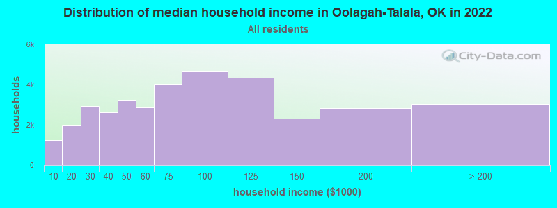
| Oolagah-Talala: | $70,289 |
| OK: | $59,673 |
Estimated per capita income in 2022: $33,283 (it was $17,723 in 2000)
Oolagah-Talala CCD income, earnings, and wages data
Estimated median house or condo value in 2022: $210,547 (it was $78,800 in 2000)
| Oolagah-Talala: | $210,547 |
| OK: | $191,700 |
Oolagah-Talala, OK residents, houses, and apartments details
Detailed information about poverty and poor residents in Oolagah-Talala, OK
Compare current foreclosures near your location:
| Photo | Address | Area | Beds / Baths | Price | Details |
|---|---|---|---|---|---|

|
#1
Bayberry Cir
Columbus, OH 43207
|
1,564 sq. feet
|
1 baths 3 beds |
$127,500
|
show details |

|
#2
S High St
Columbus, OH 43207
|
1,678 sq. feet
|
2 baths 4 beds |
$31,900
|
show details |

|
#3
E 21st Ave
Columbus, OH 43211
|
1,061 sq. feet
|
1 baths 3 beds |
$187,900
|
show details |

|
#4
N 18th St
Columbus, OH 43203
|
1,690 sq. feet
|
1 baths 4 beds |
show details | |

|
#5
N Roys Ave
Columbus, OH 43204
|
1,248 sq. feet
|
2 baths 3 beds |
show details | |

|
#6
Hiawatha Park Dr
Columbus, OH 43211
|
1,278 sq. feet
|
1 baths 4 beds |
show details | |

|
#7
E Howard Rd
Columbus, OH 43207
|
1,056 sq. feet
|
1 baths 3 beds |
show details | |

|
#8
High Free Pike
West Jefferson, OH 43162
|
1,216 sq. feet
|
2 baths 4 beds |
show details | |

|
#9
Marshrun Dr
Grove City, OH 43123
|
2,036 sq. feet
|
2 baths 4 beds |
show details | |

|
#10
S Richardson Ave
Columbus, OH 43204
|
1,520 sq. feet
|
2 baths 3 beds |
show details |
| Photo | Address | Area | Beds / Baths | Price | Details |
|---|---|---|---|---|---|

|
#11
Fergus Rd
Grove City, OH 43123
|
3,312 sq. feet
|
2 baths 4 beds |
show details | |

|
#12
Mink St SW
Pataskala, OH 43062
|
1,442 sq. feet
|
1 baths 3 beds |
show details | |

|
#13
Summertree Ln
Westerville, OH 43081
|
2,496 sq. feet
|
2 baths 3 beds |
show details | |

|
#14
Lehner Rd
Columbus, OH 43224
|
1,628 sq. feet
|
2 baths 4 beds |
show details | |

|
#15
Armada Rd
Columbus, OH 43232
|
1,028 sq. feet
|
1 baths 4 beds |
show details | |

|
#16
Meadowbrook Dr
Columbus, OH 43207
|
1,752 sq. feet
|
2 baths 4 beds |
show details | |

|
#17
Falls Peak Ln
Delaware, OH 43015
|
1,352 sq. feet
|
2 baths 2 beds |
show details | |

|
#18
Striebel Ct
Columbus, OH 43227
|
925 sq. feet
|
1 baths 3 beds |
show details | |

|
#19
Midland Ave
Columbus, OH 43223
|
1,518 sq. feet
|
1 baths 2 beds |
show details | |

|
#20
Trotter Dr
Columbus, OH 43207
|
1,478 sq. feet
|
1 baths 3 beds |
show details |
| Photo | Address | Area | Beds / Baths | Price | Details |
|---|---|---|---|---|---|

|
#21
S Hague Ave
Columbus, OH 43204
|
979 sq. feet
|
1 baths 2 beds |
show details | |

|
#22
Grasmere Ave
Columbus, OH 43211
|
720 sq. feet
|
1 baths 2 beds |
show details | |

|
#23
E Welch Ave
Columbus, OH 43207
|
1,864 sq. feet
|
2 baths 4 beds |
show details | |

|
#24
N Wayne Ave
Columbus, OH 43204
|
947 sq. feet
|
1 baths 3 beds |
show details | |

|
#25
Mayflower Blvd
Columbus, OH 43213
|
1,591 sq. feet
|
2 baths 4 beds |
show details | |

|
#26
Bretton Pl
Columbus, OH 43211
|
1,056 sq. feet
|
1 baths 3 beds |
show details | |

|
#27
Stoneybrook Blvd # 21a
Hilliard, OH 43026
|
1,231 sq. feet
|
2 baths 3 beds |
show details | |

|
#28
Derrer Rd -872
Columbus, OH 43204
|
1,667 sq. feet
|
2 baths 5 beds |
show details | |

|
#29
Kingsglen Dr
Grove City, OH 43123
|
1,635 sq. feet
|
2 baths 4 beds |
show details | |

|
#30
Elaine Rd
Columbus, OH 43213
|
764 sq. feet
|
1 baths 2 beds |
show details |
| Photo | Address | Area | Beds / Baths | Price | Details |
|---|---|---|---|---|---|

|
#31
Bernadette Rd
Columbus, OH 43204
|
1,168 sq. feet
|
1 baths 3 beds |
show details | |

|
#32
Scottwood Rd
Columbus, OH 43227
|
1,008 sq. feet
|
1 baths 3 beds |
show details | |

|
#33
Rosewood Ct
Powell, OH 43065
|
2,801 sq. feet
|
3 baths 4 beds |
show details | |

|
#34
Hildreth Ave
Columbus, OH 43203
|
1,798 sq. feet
|
2 baths 4 beds |
show details | |

|
#35
London Groveport Rd
Grove City, OH 43123
|
816 sq. feet
|
1 baths 2 beds |
show details | |

|
#36
Brookstone Dr
Westerville, OH 43082
|
1,783 sq. feet
|
3 baths 3 beds |
show details | |

|
#37
Chester Rd
Columbus, OH 43221
|
3,300 sq. feet
|
4 baths 5 beds |
show details | |

|
#38
Fahlander Dr N
Columbus, OH 43229
|
1,338 sq. feet
|
2 baths 3 beds |
show details | |

|
#39
Sleeping Meadow Dr
New Albany, OH 43054
|
3,211 sq. feet
|
2 baths 4 beds |
show details | |

|
#40
Fairfield Ave
Columbus, OH 43203
|
984 sq. feet
|
1 baths 2 beds |
show details |
| Photo | Address | Area | Beds / Baths | Price | Details |
|---|---|---|---|---|---|

|
#41
Glenmate Ct
Columbus, OH 43223
|
1,050 sq. feet
|
1 baths 3 beds |
show details | |

|
#42
N Grener Ave
Columbus, OH 43228
|
1,120 sq. feet
|
1 baths 3 beds |
show details | |

|
#43
Edgeview Rd
Columbus, OH 43207
|
1,700 sq. feet
|
1 baths 4 beds |
show details | |

|
#44
Renford Ct
Powell, OH 43065
|
1,795 sq. feet
|
1 baths 3 beds |
show details | |

|
#45
Windy Hill Ln
Galloway, OH 43119
|
1,108 sq. feet
|
2 baths 3 beds |
show details | |

|
#46
Oreily Dr
Galloway, OH 43119
|
1,533 sq. feet
|
2 baths 3 beds |
show details | |

|
#47
Mango Ln
Hilliard, OH 43026
|
1,024 sq. feet
|
1 baths 2 beds |
show details | |

|
#48
Bostwick Rd
Columbus, OH 43227
|
1,284 sq. feet
|
1 baths 4 beds |
show details | |

|
#49
Pendent Ln
Columbus, OH 43207
|
1,260 sq. feet
|
2 baths 3 beds |
show details | |

|
Check over 1 million property listings on Foreclosure.com!
|
browse all offers | |||

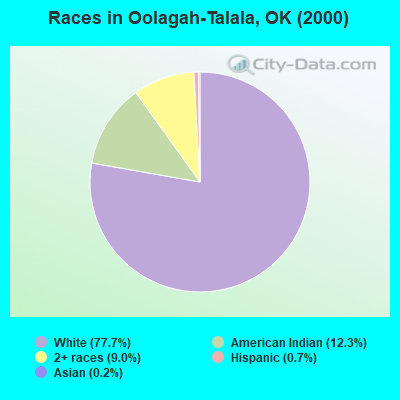
- 4,05577.7%White alone
- 63912.3%American Indian alone
- 4689.0%Two or more races
- 370.7%Hispanic
- 110.2%Asian alone
- 50.10%Black alone
- 10.02%Native Hawaiian and Other
Pacific Islander alone
Races in Oolagah-Talala detailed stats: ancestries, foreign born residents, place of birth
 Recent articles from our blog. Our writers, many of them Ph.D. graduates or candidates, create easy-to-read articles on a wide variety of topics.
Current Local Time: CST time zone
Land area: 144.9 square miles.
Population density: 42 people per square mile (very low).
| Oolagah-Talala CCD: | 0.7% ($554) |
| Oklahoma: | 0.8% ($523) |
Nearest city with pop. 50,000+: Tulsa, OK  (26.8 miles , pop. 393,049).
Nearest city with pop. 1,000,000+: Dallas, TX (261.3 miles , pop. 1,188,580).
Nearest cities:
), ), )Latitude: 36.47 N, Longitude: 95.71 W
Area code commonly used in this area: 918
| Here: | 3.0% |
| Oklahoma: | 3.2% |
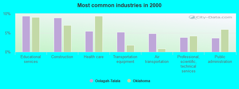
- Educational services (9.4%)
- Construction (8.9%)
- Health care (5.4%)
- Transportation equipment (5.2%)
- Air transportation (4.8%)
- Professional, scientific, technical services (3.8%)
- Public administration (3.7%)
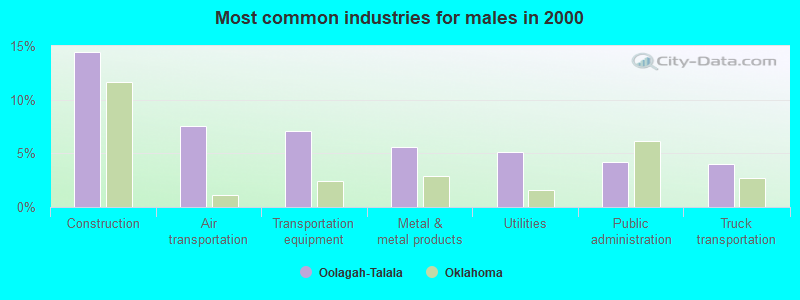
- Construction (14.5%)
- Air transportation (7.6%)
- Transportation equipment (7.1%)
- Metal & metal products (5.6%)
- Utilities (5.1%)
- Public administration (4.2%)
- Truck transportation (4.0%)
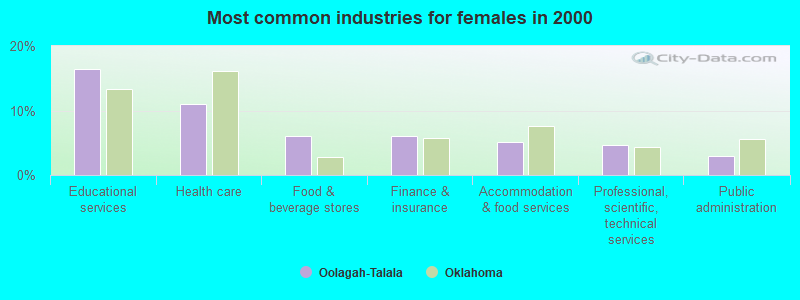
- Educational services (16.4%)
- Health care (11.0%)
- Food & beverage stores (6.1%)
- Finance & insurance (6.0%)
- Accommodation & food services (5.0%)
- Professional, scientific, technical services (4.7%)
- Public administration (3.0%)
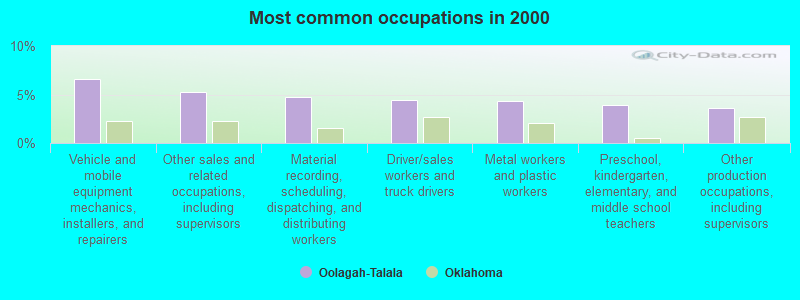
- Vehicle and mobile equipment mechanics, installers, and repairers (6.6%)
- Other sales and related occupations, including supervisors (5.3%)
- Material recording, scheduling, dispatching, and distributing workers (4.8%)
- Driver/sales workers and truck drivers (4.4%)
- Metal workers and plastic workers (4.3%)
- Preschool, kindergarten, elementary, and middle school teachers (3.9%)
- Other production occupations, including supervisors (3.6%)
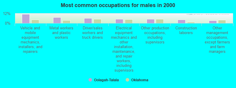
- Vehicle and mobile equipment mechanics, installers, and repairers (11.4%)
- Metal workers and plastic workers (7.2%)
- Driver/sales workers and truck drivers (6.0%)
- Electrical equipment mechanics and other installation, maintenance, and repair workers, including supervisors (5.1%)
- Other production occupations, including supervisors (4.9%)
- Construction laborers (4.5%)
- Other management occupations, except farmers and farm managers (3.3%)

- Other sales and related occupations, including supervisors (8.2%)
- Material recording, scheduling, dispatching, and distributing workers (7.4%)
- Preschool, kindergarten, elementary, and middle school teachers (7.0%)
- Secretaries and administrative assistants (6.1%)
- Other office and administrative support workers, including supervisors (4.8%)
- Customer service representatives (3.9%)
- Registered nurses (3.7%)
Average climate in Oolagah-Talala, Oklahoma
Based on data reported by over 4,000 weather stations


(lower is better)
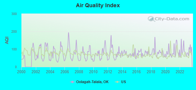
Air Quality Index (AQI) level in 2023 was 93.5. This is worse than average.
| City: | 93.5 |
| U.S.: | 72.6 |
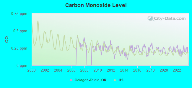
Carbon Monoxide (CO) [ppm] level in 2023 was 0.231. This is about average. Closest monitor was 23.8 miles away from the city center.
| City: | 0.231 |
| U.S.: | 0.251 |
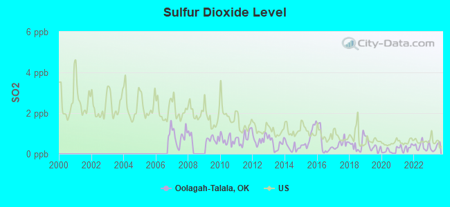
Sulfur Dioxide (SO2) [ppb] level in 2023 was 0.320. This is significantly better than average. Closest monitor was 2.4 miles away from the city center.
| City: | 0.320 |
| U.S.: | 1.515 |
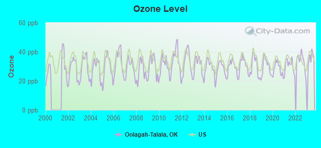
Ozone [ppb] level in 2023 was 35.5. This is about average. Closest monitor was 10.0 miles away from the city center.
| City: | 35.5 |
| U.S.: | 33.3 |
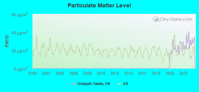
Particulate Matter (PM10) [µg/m3] level in 2023 was 30.2. This is significantly worse than average. Closest monitor was 23.8 miles away from the city center.
| City: | 30.2 |
| U.S.: | 19.2 |
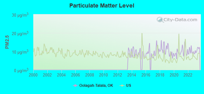
Particulate Matter (PM2.5) [µg/m3] level in 2023 was 11.0. This is worse than average. Closest monitor was 23.8 miles away from the city center.
| City: | 11.0 |
| U.S.: | 8.1 |
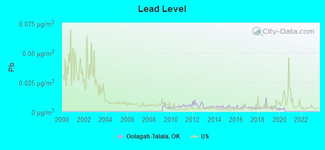
Lead (Pb) [µg/m3] level in 2019 was 0.00294. This is significantly better than average. Closest monitor was 23.8 miles away from the city center.
| City: | 0.00294 |
| U.S.: | 0.00931 |
Tornado activity:
Oolagah-Talala-area historical tornado activity is near Oklahoma state average. It is 155% greater than the overall U.S. average.
On 4/26/1991, a category F4 (max. wind speeds 207-260 mph) tornado 1.6 miles away from the Oolagah-Talala place center injured 22 people and caused between $5,000,000 and $50,000,000 in damages.
On 4/26/1991, a category F4 tornado 17.5 miles away from the place center killed one person and injured 24 people and caused between $500,000 and $5,000,000 in damages.
Earthquake activity:
Oolagah-Talala-area historical earthquake activity is significantly above Oklahoma state average. It is 780% greater than the overall U.S. average.On 9/3/2016 at 12:02:44, a magnitude 5.8 (5.8 MW, Depth: 3.5 mi, Class: Moderate, Intensity: VI - VII) earthquake occurred 68.1 miles away from Oolagah-Talala center
On 11/6/2011 at 03:53:10, a magnitude 5.7 (5.7 MW, Depth: 3.2 mi) earthquake occurred 87.9 miles away from the city center
On 11/7/2016 at 01:44:24, a magnitude 5.0 (5.0 MW, Depth: 2.8 mi) earthquake occurred 69.6 miles away from the city center
On 11/5/2011 at 07:12:45, a magnitude 4.8 (4.8 MW, Depth: 1.9 mi, Class: Light, Intensity: IV - V) earthquake occurred 86.9 miles away from Oolagah-Talala center
On 11/8/2011 at 02:46:57, a magnitude 4.8 (4.8 MW, Depth: 3.1 mi) earthquake occurred 88.8 miles away from the city center
On 11/12/2014 at 21:40:00, a magnitude 4.9 (4.9 MW, Depth: 2.5 mi) earthquake occurred 119.5 miles away from the city center
Magnitude types: moment magnitude (MW)
Natural disasters:
The number of natural disasters in Rogers County (25) is a lot greater than the US average (15).Major Disasters (Presidential) Declared: 17
Emergencies Declared: 5
Causes of natural disasters: Floods: 11, Storms: 11, Winter Storms: 10, Tornadoes: 7, Winds: 2, Heavy Rain: 1, Hurricane: 1, Ice Storm: 1, Snowstorm: 1, Other: 1 (Note: some incidents may be assigned to more than one category).
Hospitals and medical centers near Oolagah-Talala:
- ROBISON HOMECARE, INC (Home Health Center, about 2 miles away; OOLOGAH, OK)
- WOOD MANOR NURSING CENTER (Nursing Home, about 5 miles away; CLAREMORE, OK)
- MEMORIAL HOSPITAL COMPANY (Hospital, about 11 miles away; COLLINSVILLE, OK)
- FRANCES STREITEL VILLA (Nursing Home, about 11 miles away; COLLINSVILLE, OK)
- CLAREMORE INDIAN HOSPITAL Acute Care Hospitals (about 12 miles away; CLAREMORE, OK)
- HILLCREST HOSPITAL CLAREMORE Acute Care Hospitals (about 12 miles away; CLAREMORE, OK)
- CLAREMORE REGIONAL MEDICAL CENTER SNF (Nursing Home, about 12 miles away; CLAREMORE, OK)
Colleges/universities with over 2000 students nearest to Oolagah-Talala:
- Rogers State University (about 12 miles; Claremore, OK; Full-time enrollment: 3,482)
- University of Tulsa (about 26 miles; Tulsa, OK; FT enrollment: 3,702)
- Tulsa Community College (about 28 miles; Tulsa, OK; FT enrollment: 12,480)
- Oral Roberts University (about 33 miles; Tulsa, OK; FT enrollment: 3,216)
- Northeastern Oklahoma A&M College (about 55 miles; Miami, OK; FT enrollment: 2,075)
- Northeastern State University (about 57 miles; Tahlequah, OK; FT enrollment: 6,895)
- Oklahoma State University Institute of Technology (about 60 miles; Okmulgee, OK; FT enrollment: 3,243)
Points of interest:
Notable locations in Oolagah-Talala: Northwest Rogers County Fire Protection District Headquarters (A), Northwest Rogers County Fire Protection District Station 2 (B), Oologah - Talala Emergency Management Service District (C), Will Rogers Home (D). Display/hide their locations on the map
Churches in Oolagah-Talala include: Zion Hill Church (A), Rabb Creek Church (B). Display/hide their locations on the map
Cemeteries: Wann Cemetery (1), Fair View Cemetery (2), Bushyhead Cemetery (3), Oologah Cemetery (4). Display/hide their locations on the map
Reservoirs: Lower Black Bear Site 2 Reservoir (A), Oknoname 131011 Reservoir (B), Wagoner Lake (C). Display/hide their locations on the map
Creeks: Talala Creek (A), Rabb Creek (B), Fourmile Creek (C). Display/hide their locations on the map
Parks in Oolagah-Talala include: Will Rogers State Park (1), Stilling Basin Public Use Area (2), Dam Site West Public Use Area (3). Display/hide their locations on the map
| This place: | 2.8 people |
| Oklahoma: | 2.5 people |
| This place: | 79.1% |
| Whole state: | 66.8% |
| This place: | 5.7% |
| Whole state: | 5.9% |
Likely homosexual households (counted as self-reported same-sex unmarried-partner households)
- Lesbian couples: 0.4% of all households
- Gay men: 0.4% of all households
| This place: | 8.0% |
| Whole state: | 14.7% |
| This place: | 4.0% |
| Whole state: | 6.1% |
For population 15 years and over in Oolagah-Talala:
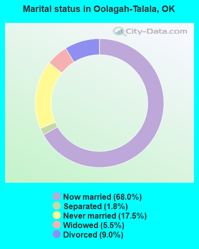
- Never married: 17.5%
- Now married: 68.0%
- Separated: 1.8%
- Widowed: 5.5%
- Divorced: 9.0%
For population 25 years and over in Oolagah-Talala:
- High school or higher: 86.1%
- Bachelor's degree or higher: 15.0%
- Graduate or professional degree: 3.0%
- Unemployed: 3.5%
- Mean travel time to work (commute): 27.7 minutes
| Here: | 8.7 |
| Oklahoma average: | 11.7 |
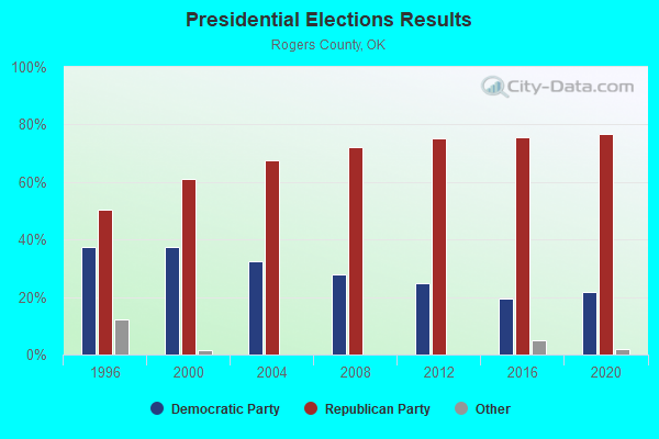
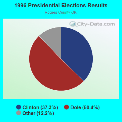

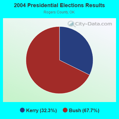
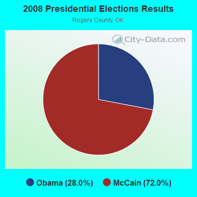
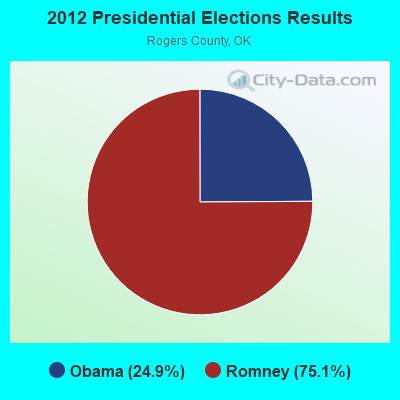
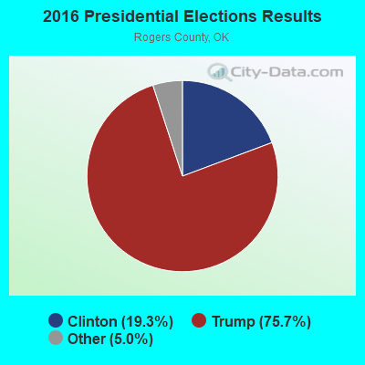
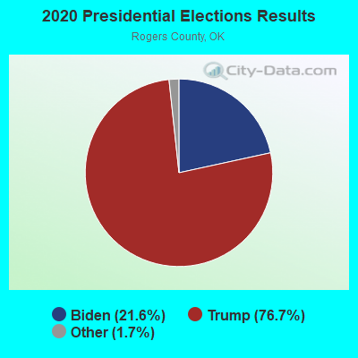
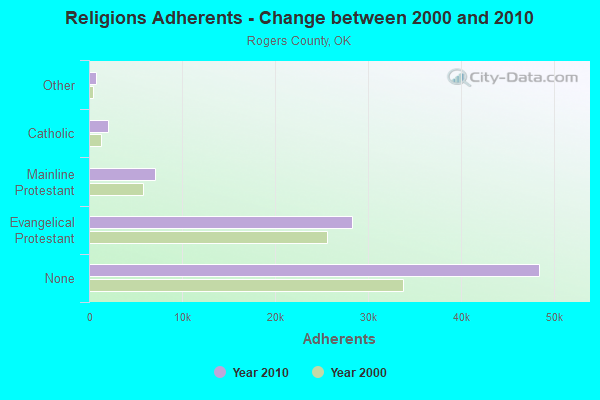
Graphs represent county-level data. Detailed 2008 Election Results
Religion statistics for Oolagah-Talala, OK (based on Rogers County data)
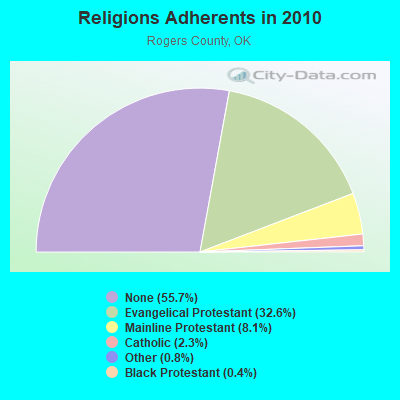
| Religion | Adherents | Congregations |
|---|---|---|
| Evangelical Protestant | 28,301 | 95 |
| Mainline Protestant | 7,079 | 14 |
| Catholic | 2,000 | 1 |
| Other | 714 | 3 |
| Black Protestant | 374 | 3 |
| None | 48,437 | - |
Food Environment Statistics:
| This county: | 0.84 / 10,000 pop. |
| Oklahoma: | 1.97 / 10,000 pop. |
| Rogers County: | 0.12 / 10,000 pop. |
| Oklahoma: | 0.20 / 10,000 pop. |
| Rogers County: | 0.60 / 10,000 pop. |
| State: | 0.76 / 10,000 pop. |
| This county: | 2.89 / 10,000 pop. |
| Oklahoma: | 4.35 / 10,000 pop. |
| Rogers County: | 4.70 / 10,000 pop. |
| Oklahoma: | 6.89 / 10,000 pop. |
| This county: | 10.8% |
| State: | 10.3% |
| Here: | 32.3% |
| Oklahoma: | 29.2% |
Strongest AM radio stations in Oolagah-Talala:
- KFAQ (1170 AM; 50 kW; TULSA, OK; Owner: JOURNAL BROADCAST CORPORATION)
- KTBZ (1430 AM; 25 kW; TULSA, OK; Owner: CLEAR CHANNEL BROADCASTING LICENSES, INC.)
- KRMG (740 AM; 50 kW; TULSA, OK; Owner: CXR HOLDINGS, INC.)
- KMUS (1380 AM; 20 kW; MUSKOGEE, OK; Owner: ABC, INC.)
- KGGF (690 AM; 10 kW; COFFEYVILLE, KS; Owner: KGGF-KUSN, INC.)
- KRVT (1270 AM; 1 kW; CLAREMORE, OK; Owner: REUNION BROADCASTING, L.L.C.)
- KCFO (970 AM; 2 kW; TULSA, OK; Owner: FRIENDSHIP BROADCASTING, L. P.)
- KAKC (1300 AM; 5 kW; TULSA, OK; Owner: CLEAR CHANNEL BROADCASTING LICENSES, INC.)
- KXTD (1530 AM; daytime; 5 kW; WAGONER, OK; Owner: GAYTAN-GALVAN LIMITED LIABILITY COMP)
- KOMA (1520 AM; 50 kW; OKLAHOMA CITY, OK; Owner: RENDA BROADCASTING CORP. OF NEVADA)
- KKOW (860 AM; 10 kW; PITTSBURG, KS; Owner: AMERICAN MEDIA INVESTMENTS)
- WHB (810 AM; 50 kW; KANSAS CITY, MO; Owner: UNION BROADCASTING, INC.)
- KFAY (1030 AM; 10 kW; FARMINGTON, AR; Owner: CUMULUS LICENSING CORP)
Strongest FM radio stations in Oolagah-Talala:
- KQLL-FM (106.1 FM; OWASSO, OK; Owner: CLEAR CHANNEL BROADCASTING LICENSES, INC.)
- KTBT (101.5 FM; COLLINSVILLE, OK; Owner: CLEAR CHANNEL BROADCASTING LICENSES, INC.)
- KNYD (90.5 FM; BROKEN ARROW, OK; Owner: CREATIVE EDUCATIONAL MEDIA CORP. INC)
- KMOD-FM (97.5 FM; TULSA, OK; Owner: CLEAR CHANNEL BROADCASTING LICENSES, INC.)
- KRAV-FM (96.5 FM; TULSA, OK; Owner: CXR HOLDINGS, INC.)
- KWEN (95.5 FM; TULSA, OK; Owner: CXR HOLDINGS, INC.)
- KBEZ (92.9 FM; TULSA, OK; Owner: RENDA BROADCASTING CORP. OF NEVADA)
- KRSC-FM (91.3 FM; CLAREMORE, OK; Owner: BOARD OF REGENTS OF OKLAHOMA COLLEGES)
- KVOO-FM (98.5 FM; TULSA, OK; Owner: JOURNAL BROADCAST CORPORATION)
- KJSR (103.3 FM; TULSA, OK; Owner: CXR HOLDINGS, INC.)
- KMYZ-FM (104.5 FM; PRYOR, OK; Owner: SHAMROCK COMMUNICATIONS, INC.)
- KWGS (89.5 FM; TULSA, OK; Owner: THE UNIVERSITY OF TULSA)
- KTFR (100.7 FM; CHELSEA, OK; Owner: MICHAEL P. STEPHENS)
- KRIG-FM (104.9 FM; NOWATA, OK; Owner: KCD ENTERPRISES, INC.)
- KGND (107.5 FM; KETCHUM, OK; Owner: NORTHEAST OKLAHOMA BROADCAST NETWORK)
- KJMM (105.3 FM; BIXBY, OK; Owner: KJMM, INC.)
- KHTT (106.9 FM; MUSKOGEE, OK; Owner: RENDA BROADCASTING CORP. OF NEVADA)
- KYFM (100.1 FM; BARTLESVILLE, OK; Owner: KCD ENTERPRISES, INC.)
- KIZS (92.1 FM; BROKEN ARROW, OK; Owner: CLEAR CHANNEL BROADCASTING LICENSES, INC.)
- KRTQ (102.3 FM; SAND SPRINGS, OK; Owner: CXR HOLDINGS, INC.)
TV broadcast stations around Oolagah-Talala:
- KDOR (Channel 17; BARTLESVILLE, OK; Owner: TRINITY BROADCASTING NETWORK)
- KRSC-TV (Channel 35; CLAREMORE, OK; Owner: BOARD OF REGENTS OF OKLAHOMA COLLEGES)
- KJRH (Channel 2; TULSA, OK; Owner: SCRIPPS HOWARD BROADCASTING COMPANY)
- KOED-TV (Channel 11; TULSA, OK; Owner: OKLAHOMA EDUCATIONAL TELEVISION AUTHORITY)
- KOTV (Channel 6; TULSA, OK; Owner: GRIFFIN LICENSING, L.L.C.)
- KTUL (Channel 8; TULSA, OK; Owner: KTUL, LLC)
- KWHB (Channel 47; TULSA, OK; Owner: LESEA BROADCASTING CORPORATION)
- KTFO (Channel 41; TULSA, OK; Owner: CLEAR CHANNEL BROADCASTING LICENSES, INC.)
- KOKI-TV (Channel 23; TULSA, OK; Owner: CLEAR CHANNEL BROADCASTING LICENSES, INC.)
- K39CW (Channel 39; TULSA, OK; Owner: VENTANA TELEVISION, INC.)
- KTZT-LP (Channel 29; TULSA, OK; Owner: ARACELIS ORTIZ, EXECUTRIX OF THE ESTATE OF CARLOS ORTIZ)
- KOPE-LP (Channel 51; TULSA, OK; Owner: COPELAND BROADCASTING CORPORATION)
- KLOT-LP (Channel 25; TULSA, OK; Owner: EQUITY BROADCASTING CORPORATION)
- KGEB (Channel 53; TULSA, OK; Owner: UNIVERSITY BROADCASTING, INC.)
- K66EK (Channel 66; BARTLESVILLE, DEWEY, OK; Owner: WASHINGTON COUNTY TELEVISION, INC.)
FCC Registered Antenna Towers:
7- Marin Fettman, 10145 East 340 Road (Okc) (Tu02996c) (Lat: 36.530750 Lon: -95.653722), Type: 125.0, Overall height: 125 m, Registrant: T-Mobile Central LLC, Marin.Fettman@t-Mobile.Com, , Belle-vue, Phone: (425) 383-4000
- MARIN FETTMAN, 10145 East 340 Road (Okc) (Tu02996c) (Lat: 36.530750 Lon: -95.653722), Type: 125.0, Overall height: 125 m, Registrant: T-Mobile Central LLC, Marin.Fettman@t-Mobile.Com, , Belle-vue, Phone: (425) 383-4000
- Dale R Smith, 10145 East 340 Road (Okc) (Tu02996c) (Lat: 36.530750 Lon: -95.653722), Type: 125.0, Overall height: 125 m, Registrant: Mobilitie Investments Ii, LLC, Pm@mobilitie.Com, , Newpo-rt Beach, Phone: (949) 515-1500
- Edward G Roach, 10145 East 340 Road (Okc) (Tu02996c) (Lat: 36.530750 Lon: -95.653722), Type: 125.0, Overall height: 125 m, Registrant: Sba Monarch Towers Ii, LLC, Eroach@sbasite.Com, , Boca -Raton, Phone: (561) 995-7670
- Edward G Roach, 10145 East 340 Road (Ok41633-T) (Lat: 36.530750 Lon: -95.653722), Type: 125.0, Structure height: 40131 m, Overall height: 121.9 m, Registrant: Sba Monarch Towers Ii, LLC, Eroach@sbasite.Com, , Boca -Raton, Phone: (561) 995-7670
- Edward G Roach, 10145 East 340 Road (Ok41633-T) (Lat: 36.530750 Lon: -95.653722), Type: 125.0, Structure height: 40131 m, Overall height: 121.9 m, Registrant: Sba Monarch Towers Ii, LLC, Eroach@sbasite.Com, , Boca -Raton, Phone: (561) 995-7670
- Edward G Roach, 10145 East 340 Road (Ok41633-T) (Lat: 36.530750 Lon: -95.653722), Type: 125.0, Structure height: 40131 m, Overall height: 121.9 m, Registrant: Sba Monarch Towers I, LLC, Eroach@sbasite.Com, , Boca -Raton, Phone: (561) 995-7670
FCC Registered Microwave Towers:
1- TU02996C, 10145 East 340 Road (Okc) (Tu02996c) (Lat: 36.530750 Lon: -95.653722), Type: Gtower, Structure height: 125 m, Call Sign: WQVQ850,
Assigned Frequencies: 11345.0 MHz, 11345.0 MHz, 11345.0 MHz, 11345.0 MHz, 11345.0 MHz, 11345.0 MHz, 11345.0 MHz, 11345.0 MHz, Grant Date: 04/17/2015, Expiration Date: 04/17/2025, Certifier: David Werblow, Registrant: T-Mobile Usa, Inc., 12920 Se 38th Street, Bellevue, WA 98006, Phone: (425) 383-8401, Fax: (425) 383-4040, Email:
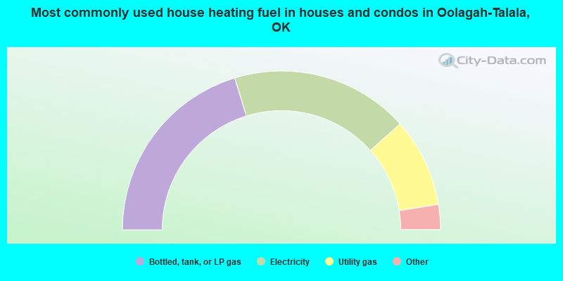
- 40.5%Bottled, tank, or LP gas
- 36.3%Electricity
- 18.1%Utility gas
- 3.5%Wood
- 0.9%No fuel used
- 0.4%Other fuel
- 0.3%Fuel oil, kerosene, etc.
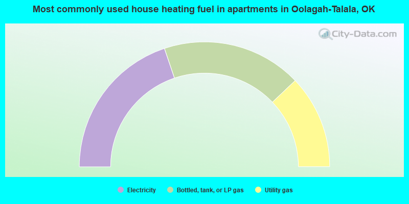
- 39.6%Electricity
- 36.1%Bottled, tank, or LP gas
- 24.2%Utility gas
Oolagah-Talala compared to Oklahoma state average:
- Unemployed percentage significantly below state average.
- Black race population percentage significantly below state average.
- Hispanic race population percentage significantly below state average.
- Foreign-born population percentage significantly below state average.
- Renting percentage below state average.
- Length of stay since moving in significantly above state average.
- Number of rooms per house significantly below state average.
- House age significantly below state average.
Oolagah-Talala on our top lists:
- #1 on the list of "Top 101 cities with largest percentage of females in occupations: drafters, engineering, and mapping technicians (population 5,000+)"
- #2 on the list of "Top 101 cities with largest percentage of males in industries: air transportation (population 5,000+)"
- #4 on the list of "Top 101 cities with largest percentage of females in occupations: material recording, scheduling, dispatching, and distributing workers (population 5,000+)"
- #5 on the list of "Top 101 cities with largest percentage of males in occupations: vehicle and mobile equipment mechanics, installers, and repairers (population 5,000+)"
- #6 on the list of "Top 101 cities with largest percentage of females in occupations: driver/sales workers and truck drivers (population 5,000+)"
- #8 on the list of "Top 101 cities with largest percentage of females in occupations: architects, surveyors, and cartographers (population 5,000+)"
- #11 on the list of "Top 101 cities with largest percentage of males in occupations: plant and system operators (population 5,000+)"
- #24 on the list of "Top 101 cities with largest percentage of females in industries: electrical equipment, appliances, and components (population 5,000+)"
- #44 on the list of "Top 101 cities with largest percentage of females in industries: truck transportation (population 5,000+)"
- #48 on the list of "Top 101 cities with largest percentage of females in industries: other transportation, and support activities, and couriers (population 5,000+)"
- #55 on the list of "Top 101 cities with largest percentage of females in industries: food and beverage stores (population 5,000+)"
- #60 on the list of "Top 101 cities with largest percentage of males in industries: used merchandise, gift, novelty, and souvenir, and other miscellaneous stores (population 5,000+)"
- #61 on the list of "Top 101 cities with largest percentage of females in industries: broadcasting and telecommunications (population 5,000+)"
- #78 on the list of "Top 101 cities with largest percentage of females in industries: u. s. postal service (population 5,000+)"
- #87 on the list of "Top 101 cities with largest percentage of males in industries: drugs, sundries, and chemical and allied products merchant wholesalers (population 5,000+)"
- #89 on the list of "Top 101 cities with largest percentage of females in industries: transportation equipment (population 5,000+)"
- #99 on the list of "Top 101 cities with largest percentage of males in industries: transportation equipment (population 5,000+)"
- #39 on the list of "Top 101 counties with highest percentage of residents voting for Romney (Republican) in the 2012 Presidential Election (pop. 50,000+)"
- #52 on the list of "Top 101 counties with the highest percentage of residents that smoked 100+ cigarettes in their lives"
- #56 on the list of "Top 101 counties with the lowest percentage of residents that exercised in the past month"
- #71 on the list of "Top 101 counties with the lowest percentage of residents relocating to foreign countries in 2011"
- #83 on the list of "Top 101 counties with the worst general health status score of residents (1-5), 3 years of data"