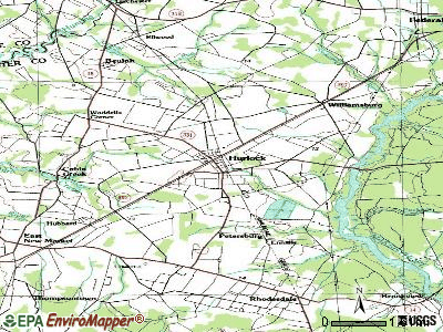
Hurlock, Maryland
Submit your own pictures of this town and show them to the world
- OSM Map
- General Map
- Google Map
- MSN Map
Population change since 2000: +10.8%
 |
| Males: 892 | |
| Females: 1,185 |
| Median resident age: | 39.8 years |
| Maryland median age: | 39.7 years |
Zip codes: 21643.
| Hurlock: | $55,293 |
| MD: | $94,991 |
Estimated per capita income in 2022: $28,114 (it was $15,446 in 2000)
Hurlock town income, earnings, and wages data
Estimated median house or condo value in 2022: $169,703 (it was $73,100 in 2000)
| Hurlock: | $169,703 |
| MD: | $398,100 |
Median gross rent in 2022: $908.
(16.3% for White Non-Hispanic residents, 11.5% for Black residents, 10.1% for Hispanic or Latino residents, 10.2% for other race residents, 43.1% for two or more races residents)
Detailed information about poverty and poor residents in Hurlock, MD
Compare current foreclosures near Hurlock, MD:
| Photo | Address | Area | Beds / Baths | Price | Details |
|---|---|---|---|---|---|

|
#1
Hynson Rd
Hurlock, MD 21643
|
- sq. feet
|
2 baths 3 beds |
show details | |

|
#2
S Main St
Hurlock, MD 21643
|
1,757 sq. feet
|
2 baths - beds |
show details | |

|
#3
Cabin Ridge Rd
Hurlock, MD 21643
|
2,128 sq. feet
|
2 baths - beds |
show details | |

|
#4
Charles St
Hurlock, MD 21643
|
1,144 sq. feet
|
1 baths - beds |
show details | |

|
#5
Payne Rd
Hurlock, MD 21643
|
1,404 sq. feet
|
2 baths - beds |
show details | |

|
#6
Commerce St
Hurlock, MD 21643
|
1,040 sq. feet
|
1 baths - beds |
show details | |

|
#7
Rolling Acres Dr
Hurlock, MD 21643
|
1,976 sq. feet
|
2 baths - beds |
show details | |

|
#8
Arrowhead Dr
Hurlock, MD 21643
|
1,596 sq. feet
|
2 baths - beds |
show details | |

|
#9
Collins Ave
Hurlock, MD 21643
|
974 sq. feet
|
1 baths - beds |
show details | |

|
#10
River Rd
Hurlock, MD 21643
|
1,664 sq. feet
|
2 baths - beds |
show details |
| Photo | Address | Area | Beds / Baths | Price | Details |
|---|---|---|---|---|---|

|
#11
Elwood Camp Rd
Hurlock, MD 21643
|
960 sq. feet
|
1 baths - beds |
show details | |

|
#12
Bobtown Rd
Hurlock, MD 21643
|
- sq. feet
|
- baths - beds |
show details | |

|
#13
Quail Run
Hurlock, MD 21643
|
- sq. feet
|
- baths - beds |
show details | |

|
#14
Rossing St
Hurlock, MD 21643
|
- sq. feet
|
- baths - beds |
show details | |

|
#15
Magnolia Dr
Seaford, DE 19973
|
1,804 sq. feet
|
3 baths 4 beds |
show details | |

|
#16
W Central Ave
Federalsburg, MD 21632
|
1,670 sq. feet
|
1 baths 4 beds |
show details | |

|
#17
E Spruce St
Seaford, DE 19973
|
1,900 sq. feet
|
2 baths 3 beds |
show details | |

|
#18
Marsh Creek Rd
Preston, MD 21655
|
- sq. feet
|
1 baths 2 beds |
show details | |

|
#19
Lednum Ave
Preston, MD 21655
|
- sq. feet
|
2 baths 3 beds |
show details | |

|
#20
Beaver Neck Village Rd
Linkwood, MD 21835
|
1,344 sq. feet
|
2 baths 3 beds |
show details |
| Photo | Address | Area | Beds / Baths | Price | Details |
|---|---|---|---|---|---|

|
#21
Mill St
Secretary, MD 21664
|
- sq. feet
|
2 baths - beds |
show details | |

|
#22
Main St
Trappe, MD 21673
|
1,480 sq. feet
|
1 baths - beds |
show details | |

|
#23
Gannon Cir
Easton, MD 21601
|
1,856 sq. feet
|
2 baths - beds |
show details | |

|
#24
Race St
Cambridge, MD 21613
|
1,495 sq. feet
|
2 baths - beds |
show details | |

|
#25
High St
Cambridge, MD 21613
|
1,232 sq. feet
|
1 baths - beds |
show details | |

|
#26
Osprey Cir
Cambridge, MD 21613
|
2,198 sq. feet
|
2 baths - beds |
show details | |

|
#27
Rainbow Ave
Cambridge, MD 21613
|
1,800 sq. feet
|
2 baths - beds |
show details | |

|
#28
Eagles Nest Way
Cambridge, MD 21613
|
2,535 sq. feet
|
2 baths - beds |
show details | |

|
#29
Rosemont Ave
Cambridge, MD 21613
|
672 sq. feet
|
1 baths - beds |
show details | |

|
#30
Center St
Cambridge, MD 21613
|
576 sq. feet
|
1 baths - beds |
show details |
| Photo | Address | Area | Beds / Baths | Price | Details |
|---|---|---|---|---|---|

|
#31
Center St
Laurel, DE 19956
|
1,200 sq. feet
|
- baths 4 beds |
show details | |

|
#32
Magnolia Trl
Cambridge, MD 21613
|
1,410 sq. feet
|
2 baths - beds |
show details | |

|
#33
Central Ave
Cambridge, MD 21613
|
948 sq. feet
|
1 baths - beds |
show details | |

|
#34
Concord Pond Rd
Seaford, DE 19973
|
1,800 sq. feet
|
- baths 3 beds |
show details | |

|
#35
Caribbean Ave
Cambridge, MD 21613
|
3,023 sq. feet
|
2 baths - beds |
show details | |

|
#36
Appleby School Rd
Cambridge, MD 21613
|
2,152 sq. feet
|
2 baths - beds |
show details | |

|
#37
Robbins St
Cambridge, MD 21613
|
1,248 sq. feet
|
1 baths - beds |
show details | |

|
#38
Stone Boundary Rd
Cambridge, MD 21613
|
1,590 sq. feet
|
1 baths - beds |
show details | |

|
#39
William St
Cambridge, MD 21613
|
2,256 sq. feet
|
2 baths - beds |
show details | |

|
#40
Double Fork Rd
Greenwood, DE 19950
|
1,568 sq. feet
|
- baths 3 beds |
show details |
| Photo | Address | Area | Beds / Baths | Price | Details |
|---|---|---|---|---|---|

|
#41
Athol Rd
Mardela Springs, MD 21837
|
1,456 sq. feet
|
2 baths - beds |
show details | |

|
#42
Wood Duck Dr
Cambridge, MD 21613
|
2,420 sq. feet
|
2 baths - beds |
show details | |

|
#43
Tour Dr
Easton, MD 21601
|
1,756 sq. feet
|
2 baths - beds |
show details | |

|
#44
Chapel Rd
Cordova, MD 21625
|
1,160 sq. feet
|
1 baths - beds |
show details | |

|
#45
Waverly Rd
Easton, MD 21601
|
2,102 sq. feet
|
1 baths - beds |
show details | |

|
#46
Old Meadow Rd
Seaford, DE 19973
|
1,026 sq. feet
|
- baths - beds |
show details | |

|
#47
Evergreen Rd
Oxford, MD 21654
|
1,232 sq. feet
|
2 baths - beds |
show details | |

|
#48
Petunia Dr
Easton, MD 21601
|
2,200 sq. feet
|
1 baths - beds |
show details | |

|
#49
Pleasant Aly
Easton, MD 21601
|
1,008 sq. feet
|
1 baths - beds |
show details | |

|
Check over 1 million property listings on Foreclosure.com!
|
browse all offers | |||


- 1,13749.8%White alone
- 68530.0%Black alone
- 26011.4%Hispanic
- 944.1%Two or more races
- 662.9%Other race alone
- 502.2%Asian alone
Races in Hurlock detailed stats: ancestries, foreign born residents, place of birth
According to our research of Maryland and other state lists, there were 18 registered sex offenders living in Hurlock, Maryland as of May 09, 2024.
The ratio of all residents to sex offenders in Hurlock is 117 to 1.
Type |
2009 |
2010 |
2011 |
2012 |
2013 |
2014 |
2015 |
2016 |
2017 |
2018 |
2019 |
2020 |
|---|---|---|---|---|---|---|---|---|---|---|---|---|
| Murders (per 100,000) | 0 (0.0) | 0 (0.0) | 0 (0.0) | 0 (0.0) | 0 (0.0) | 0 (0.0) | 0 (0.0) | 1 (49.1) | 0 (0.0) | 0 (0.0) | 0 (0.0) | 0 (0.0) |
| Rapes (per 100,000) | 0 (0.0) | 1 (47.8) | 2 (94.7) | 1 (47.3) | 0 (0.0) | 1 (48.5) | 1 (48.8) | 0 (0.0) | 0 (0.0) | 0 (0.0) | 0 (0.0) | 1 (49.6) |
| Robberies (per 100,000) | 1 (48.3) | 4 (191.2) | 0 (0.0) | 3 (142.0) | 0 (0.0) | 0 (0.0) | 0 (0.0) | 0 (0.0) | 0 (0.0) | 1 (49.4) | 0 (0.0) | 0 (0.0) |
| Assaults (per 100,000) | 5 (241.7) | 11 (525.8) | 8 (378.8) | 6 (284.0) | 4 (194.2) | 1 (48.5) | 4 (195.3) | 4 (196.5) | 4 (198.1) | 3 (148.3) | 2 (99.4) | 2 (99.3) |
| Burglaries (per 100,000) | 23 (1,112) | 42 (2,008) | 43 (2,036) | 53 (2,508) | 17 (825.2) | 7 (339.3) | 17 (830.1) | 18 (884.1) | 17 (842.0) | 13 (642.6) | 6 (298.1) | 14 (694.8) |
| Thefts (per 100,000) | 57 (2,755) | 56 (2,677) | 56 (2,652) | 42 (1,988) | 26 (1,262) | 48 (2,327) | 61 (2,979) | 60 (2,947) | 89 (4,408) | 65 (3,213) | 68 (3,378) | 54 (2,680) |
| Auto thefts (per 100,000) | 3 (145.0) | 7 (334.6) | 4 (189.4) | 2 (94.7) | 2 (97.1) | 1 (48.5) | 4 (195.3) | 5 (245.6) | 12 (594.4) | 1 (49.4) | 7 (347.7) | 8 (397.0) |
| Arson (per 100,000) | 0 (0.0) | 1 (47.8) | 0 (0.0) | 0 (0.0) | 0 (0.0) | 2 (96.9) | 2 (97.7) | 0 (0.0) | 1 (49.5) | 1 (49.4) | 0 (0.0) | 0 (0.0) |
| City-Data.com crime index | 262.4 | 475.1 | 415.2 | 399.9 | 154.9 | 169.2 | 271.0 | 336.9 | 322.4 | 221.9 | 203.7 | 247.1 |
The City-Data.com crime index weighs serious crimes and violent crimes more heavily. Higher means more crime, U.S. average is 246.1. It adjusts for the number of visitors and daily workers commuting into cities.
Crime rate in Hurlock detailed stats: murders, rapes, robberies, assaults, burglaries, thefts, arson
Full-time law enforcement employees in 2021, including police officers: 11 (10 officers - 10 male; 0 female).
| Officers per 1,000 residents here: | 5.00 |
| Maryland average: | 2.47 |
 Recent articles from our blog. Our writers, many of them Ph.D. graduates or candidates, create easy-to-read articles on a wide variety of topics.

 | Relocating through current job to Hurlock, looking for suitable area to live. (3 replies) |
| Happy Veteran's Day 2014! (0 replies) |
| Relocating to Cambridge/Easton Area of MD and need info on schools/crime etc, please!! (18 replies) |
| Best Maryland Restaurants (90 replies) |
| Salisbury Culture (7 replies) |
Latest news from Hurlock, MD collected exclusively by city-data.com from local newspapers, TV, and radio stations
Ancestries: American (24.8%), German (7.2%), English (4.7%), Irish (3.5%), Canadian (1.1%), African (1.0%).
Current Local Time: EST time zone
Incorporated in 1892
Elevation: 45 feet
Land area: 2.50 square miles.
Population density: 830 people per square mile (low).
164 residents are foreign born (5.4% Latin America, 0.9% Asia).
| This town: | 7.2% |
| Maryland: | 15.7% |
Median real estate property taxes paid for housing units with mortgages in 2022: $2,292 (1.3%)
Median real estate property taxes paid for housing units with no mortgage in 2022: $2,159 (1.3%)
Nearest city with pop. 50,000+: Bowie, MD (52.9 miles  , pop. 50,269).
Nearest city with pop. 200,000+: Baltimore, MD (62.0 miles , pop. 651,154).
Nearest city with pop. 1,000,000+: Philadelphia, PA (102.0 miles , pop. 1,517,550).
Nearest cities:
), ), Latitude: 38.63 N, Longitude: 75.86 W
Area code: 410

Single-family new house construction building permits:
- 2022: 3 buildings, average cost: $195,000
- 2021: 1 building, cost: $225,000
- 2020: 3 buildings, average cost: $199,000
- 2019: 3 buildings, average cost: $190,000
- 2018: 5 buildings, average cost: $162,000
- 2017: 2 buildings, average cost: $130,000
- 2016: 1 building, cost: $130,000
- 2015: 4 buildings, average cost: $85,000
- 2014: 1 building, cost: $120,000
- 2011: 1 building, cost: $137,000
- 2010: 1 building, cost: $80,000
- 2009: 1 building, cost: $155,000
- 2008: 1 building, cost: $50,000
- 2007: 4 buildings, average cost: $63,800
- 2006: 9 buildings, average cost: $82,300
- 2005: 16 buildings, average cost: $149,300
- 2004: 51 buildings, average cost: $124,200
- 2003: 29 buildings, average cost: $115,800
- 2002: 11 buildings, average cost: $79,400
- 2001: 4 buildings, average cost: $61,300
- 2000: 2 buildings, average cost: $52,500
- 1999: 3 buildings, average cost: $58,300
- 1998: 1 building, cost: $114,000
- 1997: 4 buildings, average cost: $113,200
| Here: | 2.2% |
| Maryland: | 2.0% |
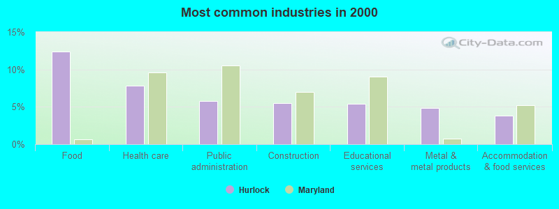
- Food (12.4%)
- Health care (7.8%)
- Public administration (5.7%)
- Construction (5.5%)
- Educational services (5.4%)
- Metal & metal products (4.8%)
- Accommodation & food services (3.9%)
- Food (11.7%)
- Construction (9.7%)
- Public administration (7.1%)
- Metal & metal products (5.8%)
- Truck transportation (5.8%)
- Computer & electronic products (4.4%)
- Educational services (3.9%)
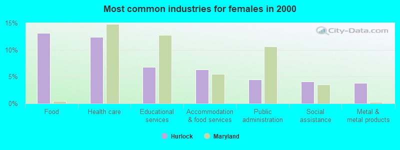
- Food (13.1%)
- Health care (12.4%)
- Educational services (6.8%)
- Accommodation & food services (6.3%)
- Public administration (4.5%)
- Social assistance (4.1%)
- Metal & metal products (3.8%)
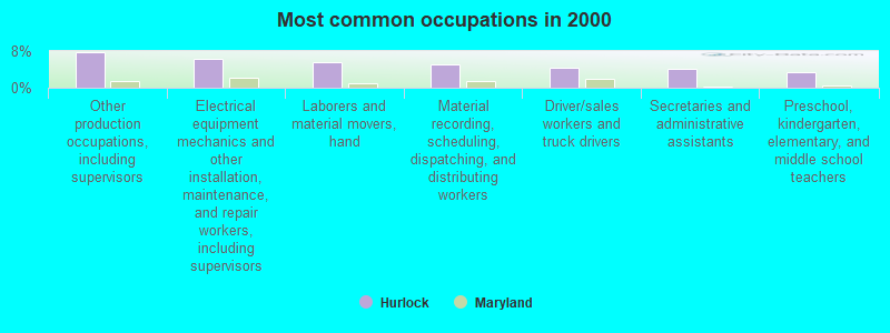
- Other production occupations, including supervisors (7.8%)
- Electrical equipment mechanics and other installation, maintenance, and repair workers, including supervisors (6.2%)
- Laborers and material movers, hand (5.6%)
- Material recording, scheduling, dispatching, and distributing workers (5.0%)
- Driver/sales workers and truck drivers (4.4%)
- Secretaries and administrative assistants (4.1%)
- Preschool, kindergarten, elementary, and middle school teachers (3.3%)
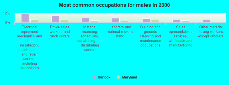
- Electrical equipment mechanics and other installation, maintenance, and repair workers, including supervisors (10.9%)
- Driver/sales workers and truck drivers (9.2%)
- Material recording, scheduling, dispatching, and distributing workers (5.8%)
- Laborers and material movers, hand (5.4%)
- Building and grounds cleaning and maintenance occupations (5.1%)
- Sales representatives, services, wholesale and manufacturing (4.1%)
- Other material moving workers, except laborers (3.9%)
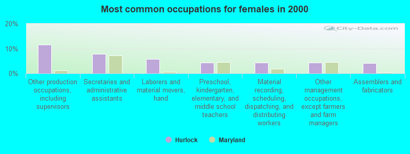
- Other production occupations, including supervisors (11.5%)
- Secretaries and administrative assistants (7.9%)
- Laborers and material movers, hand (5.9%)
- Preschool, kindergarten, elementary, and middle school teachers (4.3%)
- Material recording, scheduling, dispatching, and distributing workers (4.3%)
- Other management occupations, except farmers and farm managers (4.3%)
- Assemblers and fabricators (4.1%)
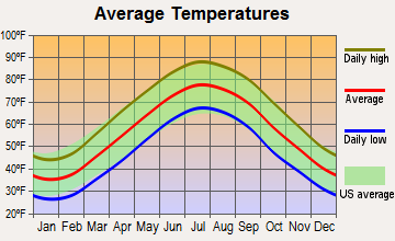
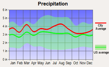
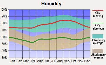
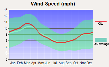
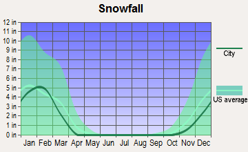
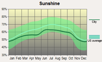
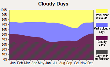
Average climate in Hurlock, Maryland
Based on data reported by over 4,000 weather stations
|
|

(lower is better)
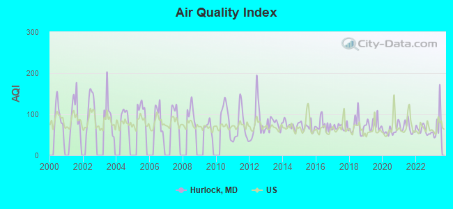
Air Quality Index (AQI) level in 2023 was 74.3. This is about average.
| City: | 74.3 |
| U.S.: | 72.6 |
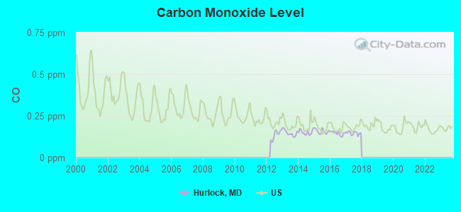
Carbon Monoxide (CO) [ppm] level in 2017 was 0.147. This is significantly better than average. Closest monitor was 15.4 miles away from the city center.
| City: | 0.147 |
| U.S.: | 0.251 |
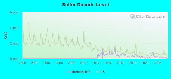
Sulfur Dioxide (SO2) [ppb] level in 2022 was 0.229. This is significantly better than average. Closest monitor was 8.7 miles away from the city center.
| City: | 0.229 |
| U.S.: | 1.515 |
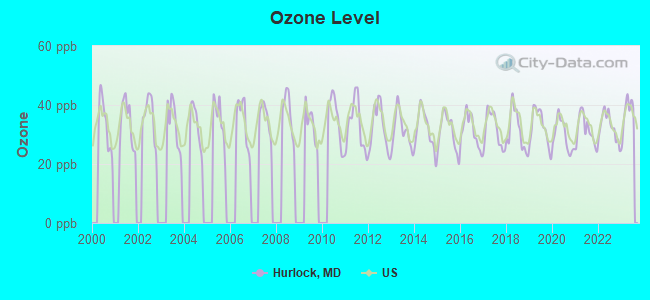
Ozone [ppb] level in 2023 was 37.4. This is about average. Closest monitor was 13.5 miles away from the city center.
| City: | 37.4 |
| U.S.: | 33.3 |
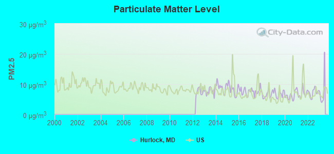
Particulate Matter (PM2.5) [µg/m3] level in 2022 was 7.33. This is about average. Closest monitor was 13.6 miles away from the city center.
| City: | 7.33 |
| U.S.: | 8.11 |
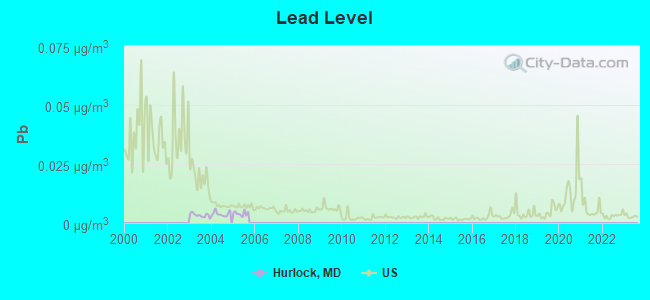
Lead (Pb) [µg/m3] level in 2005 was 0.00401. This is significantly better than average. Closest monitor was 12.4 miles away from the city center.
| City: | 0.00401 |
| U.S.: | 0.00931 |
Tornado activity:
Hurlock-area historical tornado activity is below Maryland state average. It is 35% smaller than the overall U.S. average.
On 4/28/2002, a category F4 (max. wind speeds 207-260 mph) tornado 36.1 miles away from the Hurlock town center killed 3 people and injured 122 people and caused $124 million in damages.
On 4/28/2002, a category F3 (max. wind speeds 158-206 mph) tornado 19.6 miles away from the town center caused $150,000 in damages.
Earthquake activity:
Hurlock-area historical earthquake activity is significantly above Maryland state average. It is 63% smaller than the overall U.S. average.On 8/23/2011 at 17:51:04, a magnitude 5.8 (5.8 MW, Depth: 3.7 mi, Class: Moderate, Intensity: VI - VII) earthquake occurred 123.3 miles away from Hurlock center
On 1/16/1994 at 01:49:16, a magnitude 4.6 (4.6 MB, 4.6 LG, Depth: 3.1 mi, Class: Light, Intensity: IV - V) earthquake occurred 117.9 miles away from the city center
On 8/25/2011 at 05:07:52, a magnitude 4.5 (4.5 ML, Depth: 4.2 mi) earthquake occurred 123.8 miles away from the city center
On 11/30/2017 at 21:47:31, a magnitude 4.1 (4.1 MW, Depth: 6.1 mi) earthquake occurred 45.5 miles away from Hurlock center
On 12/9/2003 at 20:59:14, a magnitude 4.5 (4.5 MB, 4.5 LG) earthquake occurred 132.5 miles away from Hurlock center
On 12/9/2003 at 20:59:18, a magnitude 4.5 (4.5 ML, Depth: 6.2 mi) earthquake occurred 135.4 miles away from the city center
Magnitude types: regional Lg-wave magnitude (LG), body-wave magnitude (MB), local magnitude (ML), moment magnitude (MW)
Natural disasters:
The number of natural disasters in Dorchester County (16) is near the US average (15).Major Disasters (Presidential) Declared: 11
Emergencies Declared: 5
Causes of natural disasters: Hurricanes: 6, Winter Storms: 4, Snowstorms: 2, Storms: 2, Tornadoes: 2, Blizzard: 1, Flood: 1, Ice Storm: 1, Snowfall: 1, Tropical Storm: 1, Other: 1 (Note: some incidents may be assigned to more than one category).
Hospitals and medical centers near Hurlock:
- CAMBRIDGE DIALYSIS CENTER (Dialysis Facility, about 12 miles away; CAMBRIDGE, MD)
- DORCHESTER GENL HOSP (Hospital, about 12 miles away; CAMBRIDGE, MD)
- DORCHESTER CNTY HLTH DEPT HHA (Home Health Center, about 13 miles away; CAMBRIDGE, MD)
- EASTERN SHORE HOSPITAL CENTER (Hospital, about 13 miles away; CAMBRIDGE, MD)
- GLASGOW NURSING HOME, INC (Nursing Home, about 13 miles away; CAMBRIDGE, MD)
- MALLARD BAY NUR AND REHAB CTR (Nursing Home, about 13 miles away; CAMBRIDGE, MD)
- SIGNATURE HEALTHCARE AT MALLARD BAY (Nursing Home, about 13 miles away; CAMBRIDGE, MD)
Airports located in Hurlock:
- Hidden Hills Airport (3MD5) (Runways: 1)
Colleges/universities with over 2000 students nearest to Hurlock:
- Salisbury University (about 25 miles; Salisbury, MD; Full-time enrollment: 8,375)
- Delaware Technical Community College-Owens (about 25 miles; Georgetown, DE; FT enrollment: 3,159)
- Wor-Wic Community College (about 27 miles; Salisbury, MD; FT enrollment: 2,256)
- University of Maryland Eastern Shore (about 31 miles; Princess Anne, MD; FT enrollment: 3,902)
- United States Naval Academy (about 42 miles; Annapolis, MD; FT enrollment: 5,681)
- Delaware State University (about 43 miles; Dover, DE; FT enrollment: 4,087)
- Delaware Technical Community College-Terry (about 43 miles; Dover, DE; FT enrollment: 2,239)
Public high school in Hurlock:
- NORTH DORCHESTER HIGH SCHOOL (Location: 5875 CLOVERDALE ROAD, Grades: 9-12)
Public elementary/middle schools in Hurlock:
- HURLOCK ELEMENTARY SCHOOL (Location: 301 CHARLES ST., Grades: PK-5)
- NORTH DORCHESTER MIDDLE SCHOOL (Location: 5745 CLOVERDALE ROAD, Grades: 6-8)
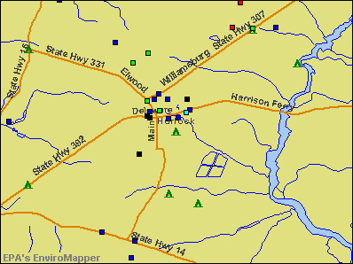
Points of interest:
Notable locations in Hurlock: Hurlock Industrial Park (A), Hurlock Volunteer Fire Company Station 6 (B), Dorchester County Emergency Medical Services 600 (C), Hurlock Library (D), Hurlock Police Department (E). Display/hide their locations on the map
Churches in Hurlock include: Faith Chapel (A), First Baptist Church (B), Grace Baptist Church (C), Muhammed Temple (D), National Church of God (E), Pilgrim Holiness Church (F), Saint Andrews Episcopal Church (G), Washington Methodist Church (H). Display/hide their locations on the map
Reservoir: Chester River Country Club Lake (A). Display/hide its location on the map
Park in Hurlock: Hurlock Park (1). Display/hide its location on the map
Birthplace of: Carlton Dotson - Basketball player.
Drinking water stations with addresses in Hurlock and their reported violations in the past:
TOWN OF HURLOCK (Population served: 2,150, Groundwater):Past health violations:BLOCH & GUGGENHEIMER CO. (Population served: 250, Groundwater):Past monitoring violations:
- MCL, Acute (TCR) - In NOV-2009, Contaminant: Coliform. Follow-up actions: St Violation/Reminder Notice (DEC-01-2009), St Public Notif requested (DEC-15-2009), St Public Notif received (DEC-18-2009), St Compliance achieved (DEC-25-2009)
- Monitoring and Reporting (DBP) - Between JAN-2010 and DEC-2010, Contaminant: Total Haloacetic Acids (HAA5). Follow-up actions: St Public Notif requested (FEB-10-2011), St Violation/Reminder Notice (FEB-10-2011), St Compliance achieved (MAY-10-2011)
- Monitoring and Reporting (DBP) - Between JAN-2010 and DEC-2010, Contaminant: TTHM. Follow-up actions: St Public Notif requested (FEB-10-2011), St Violation/Reminder Notice (FEB-10-2011), St Compliance achieved (MAY-10-2011)
- Notification, State - In NOV-2009, Contaminant: Coliform (TCR). Follow-up actions: St Violation/Reminder Notice (DEC-01-2009), St Public Notif requested (DEC-15-2009), St Public Notif received (DEC-18-2009), St Compliance achieved (DEC-25-2009)
Past health violations:Past monitoring violations:
- MCL, Monthly (TCR) - In JUN-2012, Contaminant: Coliform. Follow-up actions: St Public Notif requested (JUL-11-2012), St Violation/Reminder Notice (JUL-11-2012), St Compliance achieved (JUL-13-2012), St Intentional no-action (SEP-12-2013)
- Public Education - In MAR-03-2005, Contaminant: Lead and Copper Rule. Follow-up actions: St Compliance achieved (OCT-16-2006), St Violation/Reminder Notice (4 times from MAR-26-2007 to MAR-22-2010)
- Lead Consumer Notice - In JAN-01-2012, Contaminant: Lead and Copper Rule. Follow-up actions: St Compliance achieved (MAR-18-2013)
- Follow-up Or Routine LCR Tap M/R - In JAN-01-2009, Contaminant: Lead and Copper Rule. Follow-up actions: St Violation/Reminder Notice (JUN-10-2009), St Compliance achieved (JAN-05-2010), St Public Notif requested (MAR-03-2010), St Violation/Reminder Notice (MAR-03-2010)
- Initial, Follow-up, or Routine Source Water M/R - In JAN-01-2004, Contaminant: Lead and Copper Rule. Follow-up actions: St Violation/Reminder Notice (7 times from MAR-16-2004 to MAR-22-2010), St Compliance achieved (JUN-09-2010)
- 5 routine major monitoring violations
| This town: | 2.6 people |
| Maryland: | 2.6 people |
| This town: | 68.0% |
| Whole state: | 67.1% |
| This town: | 7.6% |
| Whole state: | 6.4% |
Likely homosexual households (counted as self-reported same-sex unmarried-partner households)
- Lesbian couples: 0.9% of all households
- Gay men: 0.0% of all households
11 people in other noninstitutional group quarters in 2000
Banks with branches in Hurlock (2011 data):
- The National Bank of Cambridge: The Hurlock Branch at South Main Street & Delaware Avenue, branch established on 1973/11/15. Info updated 2006/11/03: Bank assets: $201.2 mil, Deposits: $177.7 mil, headquarters in Cambridge, MD, negative income in the last year, Commercial Lending Specialization, 3 total offices, Holding Company: Delmarva Bancshares, Inc.
- Provident State Bank, Inc.: Hurlock Branch at 4440 Hurlock East New Market Rd, branch established on 2001/11/05. Info updated 2006/11/03: Bank assets: $256.4 mil, Deposits: $213.8 mil, headquarters in Preston, MD, positive income, Commercial Lending Specialization, 9 total offices, Holding Company: Psb Holding Corp.
For population 15 years and over in Hurlock:
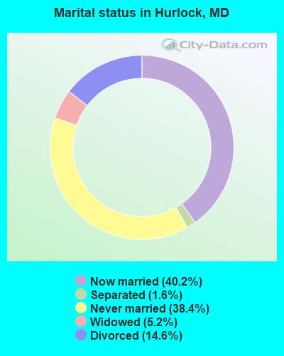
- Never married: 38.4%
- Now married: 40.2%
- Separated: 1.6%
- Widowed: 5.2%
- Divorced: 14.6%
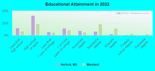
For population 25 years and over in Hurlock:
- High school or higher: 84.5%
- Bachelor's degree or higher: 12.1%
- Graduate or professional degree: 4.2%
- Unemployed: 8.4%
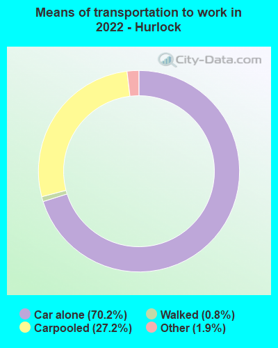
- Mean travel time to work (commute): 26.6 minutes
| Here: | 12.7 |
| Maryland average: | 12.7 |

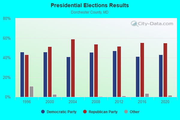
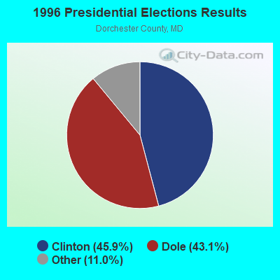


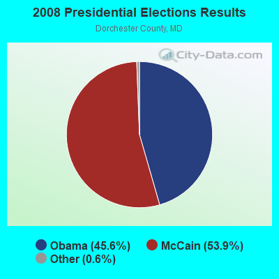
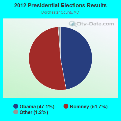


Graphs represent county-level data. Detailed 2008 Election Results
Religion statistics for Hurlock, MD (based on Dorchester County data)
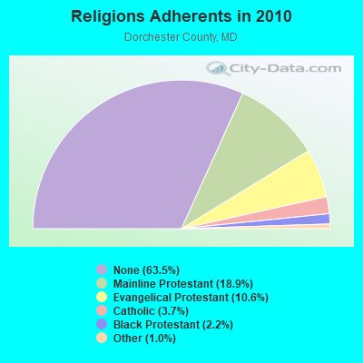
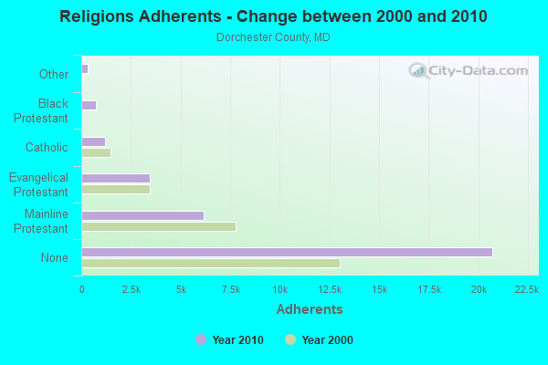
| Religion | Adherents | Congregations |
|---|---|---|
| Mainline Protestant | 6,160 | 47 |
| Evangelical Protestant | 3,460 | 31 |
| Catholic | 1,217 | 3 |
| Black Protestant | 720 | 3 |
| Other | 339 | 2 |
| None | 20,722 | - |
Food Environment Statistics:
| Dorchester County: | 2.20 / 10,000 pop. |
| Maryland: | 1.96 / 10,000 pop. |
| Dorchester County: | 1.26 / 10,000 pop. |
| Maryland: | 1.22 / 10,000 pop. |
| Dorchester County: | 5.97 / 10,000 pop. |
| State: | 2.05 / 10,000 pop. |
| This county: | 8.16 / 10,000 pop. |
| Maryland: | 5.40 / 10,000 pop. |
| Here: | 11.5% |
| Maryland: | 9.1% |
| Dorchester County: | 31.5% |
| Maryland: | 26.7% |
| Dorchester County: | 15.0% |
| State: | 15.5% |
Health and Nutrition:
| This city: | 48.8% |
| Maryland: | 50.1% |
| Here: | 45.7% |
| State: | 47.6% |
| Here: | 29.4 |
| State: | 28.8 |
| Here: | 21.3% |
| Maryland: | 20.0% |
| Hurlock: | 12.0% |
| State: | 11.3% |
| This city: | 6.8 |
| Maryland: | 6.8 |
| Hurlock: | 35.0% |
| Maryland: | 34.1% |
| This city: | 55.0% |
| Maryland: | 56.5% |
| Hurlock: | 79.5% |
| Maryland: | 80.5% |
More about Health and Nutrition of Hurlock, MD Residents
| Local government employment and payroll (March 2022) | |||||
| Function | Full-time employees | Monthly full-time payroll | Average yearly full-time wage | Part-time employees | Monthly part-time payroll |
|---|---|---|---|---|---|
| Police Protection - Officers | 9 | $45,121 | $60,161 | 0 | $0 |
| Sewerage | 3 | $17,103 | $68,412 | 0 | $0 |
| Other Government Administration | 3 | $16,663 | $66,652 | 6 | $10,332 |
| Solid Waste Management | 2 | $12,502 | $75,012 | 0 | $0 |
| Streets and Highways | 2 | $8,000 | $48,000 | 0 | $0 |
| Police - Other | 1 | $4,364 | $52,368 | 0 | $0 |
| Water Supply | 1 | $4,854 | $58,248 | 0 | $0 |
| Totals for Government | 21 | $108,606 | $62,061 | 6 | $10,332 |
Hurlock government finances - Expenditure in 2017 (per resident):
- Current Operations - Sewerage: $932,000 ($448.72)
Police Protection: $729,000 ($350.99)
Water Utilities: $587,000 ($282.62)
General - Other: $555,000 ($267.21)
Regular Highways: $440,000 ($211.84)
Central Staff Services: $254,000 ($122.29)
Solid Waste Management: $175,000 ($84.26)
Financial Administration: $155,000 ($74.63)
Local Fire Protection: $82,000 ($39.48)
Parks and Recreation: $50,000 ($24.07)
Judicial and Legal Services: $17,000 ($8.18)
General Public Buildings: $10,000 ($4.81)
- General - Interest on Debt: $152,000 ($73.18)
- Other Capital Outlay - Police Protection: $60,000 ($28.89)
General - Other: $23,000 ($11.07)
Regular Highways: $12,000 ($5.78)
Financial Administration: $9,000 ($4.33)
- Total Salaries and Wages: $1,274,000 ($613.38)
Hurlock government finances - Revenue in 2017 (per resident):
- Charges - Sewerage: $2,289,000 ($1102.07)
Solid Waste Management: $47,000 ($22.63)
- Federal Intergovernmental - Other: $16,000 ($7.70)
- Local Intergovernmental - Other: $17,000 ($8.18)
- Miscellaneous - General Revenue - Other: $27,000 ($13.00)
Rents: $15,000 ($7.22)
Interest Earnings: $11,000 ($5.30)
- Revenue - Water Utilities: $241,000 ($116.03)
- State Intergovernmental - Other: $164,000 ($78.96)
Highways: $84,000 ($40.44)
- Tax - Property: $1,459,000 ($702.46)
Individual Income: $110,000 ($52.96)
Other Selective Sales: $10,000 ($4.81)
Other License: $7,000 ($3.37)
Occupation and Business License - Other: $4,000 ($1.93)
Hurlock government finances - Debt in 2017 (per resident):
- Long Term Debt - Outstanding Unspecified Public Purpose: $4,038,000 ($1944.15)
Beginning Outstanding - Unspecified Public Purpose: $3,811,000 ($1834.86)
Issue, Unspecified Public Purpose: $2,765,000 ($1331.25)
Retired Unspecified Public Purpose: $2,539,000 ($1222.44)
Hurlock government finances - Cash and Securities in 2017 (per resident):
- Bond Funds - Cash and Securities: $123,000 ($59.22)
- Other Funds - Cash and Securities: $2,944,000 ($1417.43)
| Businesses in Hurlock, MD | ||||
| Name | Count | Name | Count | |
|---|---|---|---|---|
| Ford | 1 | Nissan | 1 | |
| Hyundai | 1 | Subway | 1 | |
| MasterBrand Cabinets | 2 | True Value | 1 | |
| Mazda | 1 | |||
Strongest AM radio stations in Hurlock:
- WTGM (960 AM; 10 kW; SALISBURY, MD; Owner: CAPSTAR TX LIMITED PARTNERSHIP)
- WBIS (1190 AM; 50 kW; ANNAPOLIS, MD; Owner: NATIONS RADIO, LLC)
- WJWL (900 AM; 10 kW; GEORGETOWN, DE; Owner: GREAT SCOTT BROADCASTING)
- WWGB (1030 AM; daytime; 50 kW; INDIAN HEAD, MD; Owner: GOOD BODY MEDIA, LLC)
- WCBM (680 AM; 50 kW; BALTIMORE, MD; Owner: WCBM MARYLAND, INC.)
- WTEM (980 AM; 50 kW; WASHINGTON, DC; Owner: AMFM RADIO LICENSES, L.L.C.)
- WWLG (1370 AM; 50 kW; BALTIMORE, MD; Owner: M-10 BROADCASTING, INC.)
- WPGC (1580 AM; 50 kW; MORNINGSIDE, MD; Owner: INFINITY WPGC(AM), INC.)
- WBAL (1090 AM; 50 kW; BALTIMORE, MD; Owner: HEARST RADIO, INC.)
- WJDY (1470 AM; 5 kW; SALISBURY, MD; Owner: CAPSTAR TX LIMITED PARTNERSHIP)
- WVCH (740 AM; 50 kW; CHESTER, PA; Owner: WVCH COMMUNICATIONS, INC.)
- WTOP (1500 AM; 50 kW; WASHINGTON, DC; Owner: BONNEVILLE HOLDING COMPANY)
- WMET (1150 AM; 50 kW; GAITHERSBURG, MD; Owner: BELTWAY ACQUISITION CORPORATION)
Strongest FM radio stations in Hurlock:
- WAAI (100.9 FM; HURLOCK, MD; Owner: MTS BROADCASTING, L.C.)
- WSCL (89.5 FM; SALISBURY, MD; Owner: SALISBURY UNIVERSITY FOUNDATION, INC.)
- WTDK (107.1 FM; FEDERALSBURG, MD; Owner: MTS BROADCASTING, L.C.)
- WINX-FM (94.3 FM; CAMBRIDGE, MD; Owner: CWA BROADCASTING, INC.)
- WCEM-FM (106.3 FM; CAMBRIDGE, MD; Owner: MTS BROADCASTING L.C.)
- WGBG (98.5 FM; SEAFORD, DE; Owner: GREAT SCOTT BROADCASTING)
- WKDB (95.3 FM; LAUREL, DE; Owner: GREAT SCOTT BROADCASTING)
- WCEI-FM (96.7 FM; EASTON, MD; Owner: FIRST MEDIA RADIO, LLC)
- WLVW-FM (105.5 FM; SALISBURY, MD; Owner: CAPSTAR TX LIMITED PARTNERSHIP)
- WESM (91.3 FM; PRINCESS ANNE, MD; Owner: UNIVERSITY OF MARYLAND, EASTERN SHORE)
- WICO-FM (97.5 FM; SALISBURY, MD; Owner: DELMARVA BROADCASTING COMPANY)
- WZBH (93.5 FM; GEORGETOWN, DE; Owner: GREAT SCOTT BROADCASTING)
- WXPZ (101.3 FM; MILFORD, DE; Owner: DELMARVA BROADCASTING COMPANY)
TV broadcast stations around Hurlock:
- WMDT (Channel 47; SALISBURY, MD; Owner: DELMARVA BROADCAST SERVICE GENERAL PARTNERSHIP)
- WBOC-TV (Channel 16; SALISBURY, MD; Owner: WBOC, INC.)
- WDPB (Channel 64; SEAFORD, DE; Owner: WHYY, INC.)
- WCPB (Channel 28; SALISBURY, MD; Owner: MARYLAND PUBLIC BROADCASTING COMMISSION)
- W38BN (Channel 38; SALISBURY, MD; Owner: SALISBURY EDUCATIONAL B/CTING FOUND.)
- Hurlock, Maryland
- Fatal accident count27
- Vehicles involved in fatal accidents41
- Fatal accidents involving drunk persons:8
- Fatalities30
- Persons involved in fatal accidents60
- Pedestrians involved in fatal accidents1
- Maryland average
- Fatal accident count10253
- Vehicles involved in fatal accidents15516
- Fatal accidents involving drunk persons3488
- Fatalities11284
- Persons involved in fatal accidents26529
- Pedestrians involved in fatal accidents1039
- National Bridge Inventory (NBI) Statistics
- 2Number of bridges
- 62ft / 19.5mTotal length
- $114,000Total costs
- 5,363Total average daily traffic
- 498Total average daily truck traffic
- 3,681Total future (year 2026) average daily traffic
FCC Registered Antenna Towers:
12 (See the full list of FCC Registered Antenna Towers in Hurlock)FCC Registered Broadcast Land Mobile Towers:
6- Charles & Delaware Aves (Lat: 38.630389 Lon: -75.863000), Call Sign: WNMB864,
Assigned Frequencies: 39.1000 MHz, Grant Date: 05/11/2022, Expiration Date: 07/31/2032, Registrant: Maryland Dept. Of State Police, 7755 Washington Blvd., Jessup, MD 20794, Phone: (410) 799-3466, Fax: (410) 799-3853, Email:
- On Skeet Club Rd .5 Mi Se (Lat: 38.621222 Lon: -75.854111), Structure height: 20 m, Call Sign: WNZQ226, Licensee ID: L00003474,
Assigned Frequencies: 48.2400 MHz, 48.3000 MHz, Grant Date: 06/04/1997, Expiration Date: 06/04/2002, Cancellation Date: 10/06/2002, Registrant: Delmarva Power And Light Company, Newark, DE 19714, Phone: (301) 860-6392
- Lat: 38.630611 Lon: -75.781056, Call Sign: WQJP690, Licensee ID: L01419403,
Assigned Frequencies: 458.087 MHz, Grant Date: 11/18/2008, Expiration Date: 11/18/2018, Cancellation Date: 02/16/2019, Certifier: Brian L Tolley, Registrant: Hurlock Vol. Fire Co., Inc., Hurlock, MD 21643, Phone: (410) 943-3110, Fax: (410) 943-4355, Email:
- Lat: 38.645556 Lon: -75.873889, Call Sign: WQSI399,
Assigned Frequencies: 159.705 MHz, Grant Date: 09/24/2013, Expiration Date: 09/24/2023, Cancellation Date: 11/25/2023, Certifier: Russell Stevens, Registrant: Cara Enterprises Inc, Las Vegas, NV 89140-0124, Phone: (702) 838-9728, Fax: (702) 363-4607, Email:
- Lat: 38.634167 Lon: -75.859444, Call Sign: WQUY622,
Assigned Frequencies: 151.775 MHz, 159.780 MHz, 160.125 MHz, Grant Date: 11/18/2014, Expiration Date: 11/18/2024, Certifier: Douglas Smith, Registrant: Cara Enterprises, Inc, Las Vegas, NV 89140-0124, Phone: (702) 838-9728, Fax: (702) 363-4607, Email:
- Lat: 38.625583 Lon: -75.870472, Call Sign: WRTH893,
Assigned Frequencies: 452.037 MHz, 457.037 MHz, Grant Date: 06/18/2022, Expiration Date: 06/18/2032, Certifier: Maria Palermo, Registrant: Communications Electronics Inc., 8260 Patuxent Range Rd, Jessup, MD 20794, Phone: (301) 497-9080, Fax: (301) 497-9082, Email:
FCC Registered Microwave Towers:
4- Hurlock, 6301 Meadow Drive (Lat: 38.624444 Lon: -75.888889), Type: Nntann, Structure height: 152.4 m, Call Sign: WPQP550,
Assigned Frequencies: 947.625 MHz, Grant Date: 07/28/2000, Expiration Date: 10/01/2027, Certifier: Thomas C Mulitz, Registrant: Koerner & Olender, P.C., 5809 Nicholson Lane, Suite 124, N. Bethesda, MD 20852, Phone: (301) 468-3336, Fax: (301) 468-3343, Email:
- WA90XCH90, 4810 Williamsburg Rd (Lat: 38.656389 Lon: -75.840833), Type: Ltower, Structure height: 80.7 m, Call Sign: WRFQ885,
Assigned Frequencies: 10995.0 MHz, 11075.0 MHz, 10995.0 MHz, 11075.0 MHz, 10995.0 MHz, 11075.0 MHz, 10995.0 MHz, 11075.0 MHz, 10995.0 MHz, 11075.0 MHz... (+10 more), Grant Date: 04/14/2020, Expiration Date: 04/14/2030, Cancellation Date: 09/21/2021, Certifier: Garrie C Losee, Registrant: T-Mobile Usa, Inc., 12920 Se 38th Street, Bellevue, WA 98006, Phone: (425) 383-8401, Fax: (425) 383-4840, Email:
- 6301 Meadow Dr (Lat: 38.624556 Lon: -75.888528), Overall height: 92 m, Call Sign: WLE525,
Assigned Frequencies: 948.625 MHz, 948.375 MHz, Grant Date: 09/18/1995, Expiration Date: 10/01/2027, Phone: (410) 376-3032
- HURLOCK, 1.5 Miles Sw Of (Lat: 38.624556 Lon: -75.888528), Overall height: 152.4 m, Call Sign: WLR333,
Assigned Frequencies: 6004.50 MHz, 6004.50 MHz, Grant Date: 03/13/2001, Expiration Date: 02/01/2011, Cancellation Date: 07/06/2004, Certifier: Dennis W Guard Jr., Registrant: Intermedia Services LLC, 2400 North Glenville, Richardson, TX 75082, Phone: (972) 729-6406, Fax: (972) 729-2690, Email:
FCC Registered Paging Towers:
2- North Side Of Road 397 (Lat: 38.624556 Lon: -75.888528), Call Sign: KNKI217,
Assigned Frequencies: 152.660 MHz, Grant Date: 06/01/1999, Expiration Date: 04/01/2009, Cancellation Date: 05/23/2009, Registrant: O\'Brien Communications Inc., 5051 Rapidan Place, Annandale, VA 22003, Phone: (703) 354-5195
- 630 Meadow Drive (Lat: 38.624556 Lon: -75.888528), Type: Tower, Structure height: 152 m, Call Sign: KNKB613,
Assigned Frequencies: 158.100 MHz, Grant Date: 04/27/1999, Expiration Date: 06/15/2008, Cancellation Date: 11/02/2004, Certifier: William Buxbaum, Registrant: Network Services, LLC Debtor-In-Possession, 525 South Douglas Street, El Segundo, CA 90245, Phone: (310) 615-6523, Fax: (310) 615-6581, Email:
FCC Registered Amateur Radio Licenses:
5- Call Sign: KE3GI, Previous Call Sign: N3ISW, Licensee ID: L00629391, Grant Date: 10/17/2012, Expiration Date: 01/05/2023, Registrant: Parker J Durham, 400 Charles St, Hurlock, MD 21643
- Call Sign: N3JRG, Licensee ID: L00849256, Grant Date: 04/30/2014, Expiration Date: 05/31/2024, Certifier: Hamilton E Thompson, Registrant: Hamilton E Thompson, 303 Collins Ave, Hurlock, MD 21643
- Call Sign: N3NUZ, Licensee ID: L00612234, Grant Date: 12/24/2002, Expiration Date: 12/29/2012, Cancellation Date: 12/30/2014, Registrant: Christine L Durham, 400 Charles St, Hurlock, MD 21643
- Call Sign: W3GLB, Previous Call Sign: N3KQP, Licensee ID: L01504635, Grant Date: 11/13/2019, Expiration Date: 11/13/2029, Registrant: Garrie L Bostwick, 105 Center St, Hurlock, MD 21643
- Call Sign: KC3FZJ, Licensee ID: L01985083, Grant Date: 11/20/2015, Expiration Date: 11/20/2025, Certifier: Brian L Tolley, Registrant: Brian L Tolley, 4434 Rolling Acres Drive, Hurlock, MD 21643
FAA Registered Aircraft:
2- Aircraft: CESSNA 150L (Category: Land, Seats: 2, Weight: Up to 12,499 Pounds, Speed: 90 mph), Engine: CONT MOTOR 0-200 SERIES (100 HP) (Reciprocating)
N-Number: 1644Q, N1644Q, N-1644Q, Serial Number: 15072944, Year manufactured: 1971, Airworthiness Date: 10/21/1971, Certificate Issue Date: 01/08/2009
Registrant (Individual): Norman O Bell, Po Box 381, Hurlock, MD 21643 - Aircraft: LUSCOMBE 8A (Category: Land, Seats: 2, Weight: Up to 12,499 Pounds, Speed: 86 mph), Engine: CONT MOTOR A&C65 SERIES (65 HP) (Reciprocating)
N-Number: 77819, N77819, N-77819, Serial Number: 3546, Year manufactured: 1946, Airworthiness Date: 01/21/1956, Certificate Issue Date: 05/16/2012
Registrant (Individual): Lloyd Moroughan, 4620 Williamsburg Church Rd, Hurlock, MD 21643
2002 - 2018 National Fire Incident Reporting System (NFIRS) incidents
- Fire incident types reported to NFIRS in Hurlock, MD
- 51046.8%Structure Fires
- 41538.1%Outside Fires
- 11310.4%Mobile Property/Vehicle Fires
- 514.7%Other
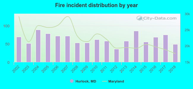 Based on the data from the years 2002 - 2018 the average number of fires per year is 64. The highest number of fire incidents - 89 took place in 2004, and the least - 36 in 2012. The data has a decreasing trend.
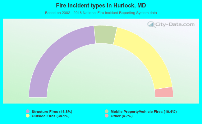 When looking into fire subcategories, the most incidents belonged to: Structure Fires (46.8%), and Outside Fires (38.1%).
| Most common first names in Hurlock, MD among deceased individuals | ||
| Name | Count | Lived (average) |
|---|---|---|
| James | 46 | 71.7 years |
| Mary | 46 | 79.2 years |
| William | 41 | 70.6 years |
| John | 32 | 74.5 years |
| George | 27 | 75.5 years |
| Charles | 26 | 76.1 years |
| Robert | 20 | 68.7 years |
| Elizabeth | 17 | 80.9 years |
| Thomas | 16 | 70.8 years |
| Edward | 16 | 76.8 years |
| Most common last names in Hurlock, MD among deceased individuals | ||
| Last name | Count | Lived (average) |
|---|---|---|
| Jones | 33 | 70.4 years |
| Smith | 29 | 70.9 years |
| Parker | 16 | 71.9 years |
| Cephas | 15 | 68.8 years |
| Thomas | 14 | 79.0 years |
| Wheatley | 12 | 77.7 years |
| Jackson | 12 | 75.4 years |
| Camper | 12 | 65.9 years |
| Aldridge | 11 | 69.7 years |
| Corkran | 11 | 78.3 years |
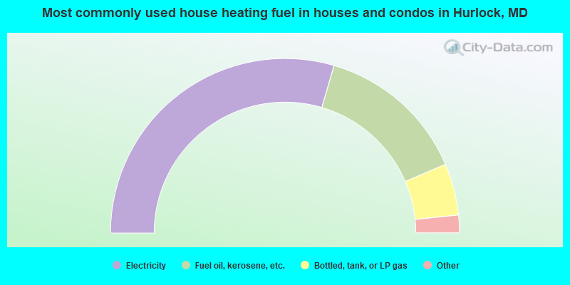
- 59.2%Electricity
- 28.1%Fuel oil, kerosene, etc.
- 9.6%Bottled, tank, or LP gas
- 1.4%Wood
- 0.9%Utility gas
- 0.5%No fuel used
- 0.3%Solar energy
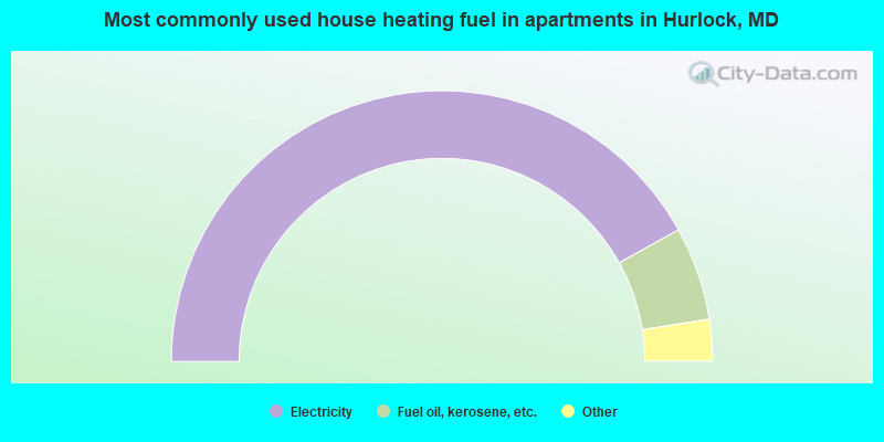
- 84.2%Electricity
- 11.2%Fuel oil, kerosene, etc.
- 2.3%Utility gas
- 1.9%Bottled, tank, or LP gas
- 0.4%No fuel used
Hurlock compared to Maryland state average:
- Median household income below state average.
- Median house value significantly below state average.
- Unemployed percentage below state average.
- Foreign-born population percentage below state average.
- Length of stay since moving in significantly above state average.
- Percentage of population with a bachelor's degree or higher significantly below state average.
Hurlock on our top lists:
- #64 on the list of "Top 101 cities with the most residents born in Haiti (population 500+)"
- #71 on the list of "Top 101 counties with the highest carbon monoxide air pollution readings in 2012 (ppm)"
- #76 on the list of "Top 101 counties with the highest Sulfur Oxides Annual air pollution readings in 2012 (µg/m3)"

|
Total of 5 patent applications in 2008-2024.