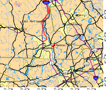
Hudson, New Hampshire
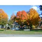
Hudson: Hudson Gazebo in Fall
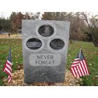
Hudson: 9/11 Memorial at Benson Park, Hudson NH
Hudson: The Hills House (now listed on the National Register of Historic Places)

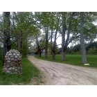
Hudson: One of the oldest home in Hudson getting a new roof
- add
your
Submit your own pictures of this place and show them to the world
- OSM Map
- General Map
- Google Map
- MSN Map
Population change since 2000: -6.1%
| Males: 4,068 | |
| Females: 3,268 |
| Median resident age: | 48.0 years |
| New Hampshire median age: | 43.3 years |
Zip codes: 03051.
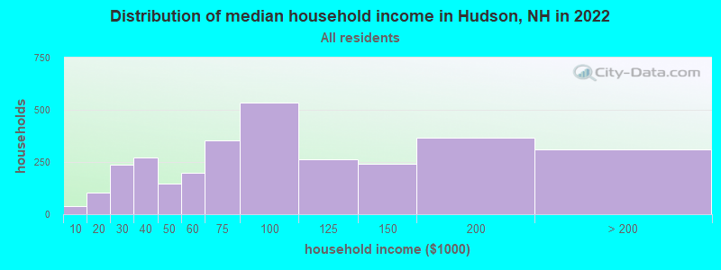
| Hudson: | $82,440 |
| NH: | $89,992 |
Estimated per capita income in 2022: $46,339 (it was $22,324 in 2000)
Hudson CDP income, earnings, and wages data
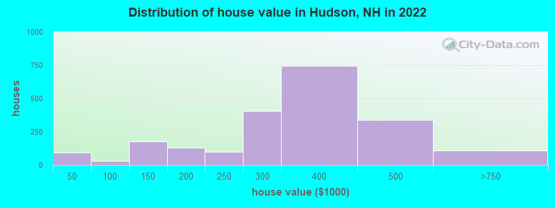
Estimated median house or condo value in 2022: $341,032 (it was $129,600 in 2000)
| Hudson: | $341,032 |
| NH: | $384,700 |
Mean prices in 2022: all housing units: $361,151; detached houses: $396,235; townhouses or other attached units: $306,217; in 5-or-more-unit structures: $183,256; mobile homes: $154,996
Median gross rent in 2022: $1,393.
(3.8% for White Non-Hispanic residents, 0.6% for Black residents, 4.5% for Hispanic or Latino residents)
Detailed information about poverty and poor residents in Hudson, NH


Compare current foreclosures near Hudson, NH:
| Photo | Address | Area | Beds / Baths | Price | Details |
|---|---|---|---|---|---|

|
#1
Willow Creek Dr # 42
Hudson, NH 03051
|
1,120 sq. feet
|
1 baths 2 beds |
show details | |

|
#2
Cheney Dr
Hudson, NH 03051
|
1,685 sq. feet
|
2 baths 3 beds |
show details | |

|
#3
Old Coach Rd
Hudson, NH 03051
|
2,630 sq. feet
|
2 baths 3 beds |
show details | |

|
#4
Bush Hill Rd
Hudson, NH 03051
|
- sq. feet
|
- baths - beds |
show details | |

|
#5
Dugout Rd
Hudson, NH 03051
|
- sq. feet
|
- baths - beds |
show details | |

|
#6
Greeley St
Hudson, NH 03051
|
- sq. feet
|
- baths - beds |
show details | |

|
#7
Derry Road, Apt A
Hudson, NH 03051
|
- sq. feet
|
- baths - beds |
show details | |

|
#8
Washington Street, A/k/a 7 Washington Drive
Hudson, NH 03051
|
- sq. feet
|
- baths - beds |
show details | |

|
#9
Maple St
Tewksbury, MA 01876
|
1,748 sq. feet
|
1 baths 4 beds |
$379,900
|
show details |

|
#10
Shore Dr
Hampstead, NH 03841
|
787 sq. feet
|
1 baths 2 beds |
$529,900
|
show details |
| Photo | Address | Area | Beds / Baths | Price | Details |
|---|---|---|---|---|---|

|
#11
Great Rd
Shirley, MA 01464
|
1,672 sq. feet
|
1 baths 2 beds |
$464,900
|
show details |

|
#12
Hedgerow D A
Hudson, NH 03051
|
- sq. feet
|
- baths - beds |
show details | |

|
#13
Springwood Cir
Hudson, NH 03051
|
- sq. feet
|
- baths - beds |
show details | |

|
#14
Hedgerow Drive Unit No. 5a
Hudson, NH 03051
|
- sq. feet
|
- baths - beds |
show details | |

|
#15
Marie Ln
Hudson, NH 03051
|
- sq. feet
|
- baths - beds |
show details | |

|
#16
Changnon Ln
Hudson, NH 03051
|
- sq. feet
|
- baths - beds |
show details | |

|
#17
Elmwood Dr
Hudson, NH 03051
|
- sq. feet
|
- baths - beds |
show details | |

|
#18
Baker St
Hudson, NH 03051
|
- sq. feet
|
- baths - beds |
show details | |

|
#19
Overlook C 33
Hudson, NH 03051
|
- sq. feet
|
- baths - beds |
show details | |

|
#20
Kimball Hill Rd
Hudson, NH 03051
|
- sq. feet
|
- baths - beds |
show details |
| Photo | Address | Area | Beds / Baths | Price | Details |
|---|---|---|---|---|---|

|
#21
Kienia Rd # B
Hudson, NH 03051
|
- sq. feet
|
- baths - beds |
show details | |

|
#22
Greeley St
Hudson, NH 03051
|
- sq. feet
|
- baths - beds |
show details | |

|
#23
Bridle Bridge Rd
Hudson, NH 03051
|
- sq. feet
|
- baths - beds |
show details | |

|
#24
2nd St
Hudson, NH 03051
|
- sq. feet
|
- baths - beds |
show details | |

|
#25
Overlook Cir
Hudson, NH 03051
|
- sq. feet
|
- baths - beds |
show details | |

|
#26
Edgar Ct
Hudson, NH 03051
|
- sq. feet
|
- baths - beds |
show details | |

|
#27
Highland St
Hudson, NH 03051
|
- sq. feet
|
- baths - beds |
show details | |

|
#28
Rangers Dr
Hudson, NH 03051
|
- sq. feet
|
- baths - beds |
show details | |

|
#29
Nashua St
Milford, NH 03055
|
2,172 sq. feet
|
2 baths 4 beds |
show details | |

|
#30
Fieldstone Dr
Amherst, NH 03031
|
2,280 sq. feet
|
3 baths 3 beds |
show details |
| Photo | Address | Area | Beds / Baths | Price | Details |
|---|---|---|---|---|---|

|
#31
Blucher St
Manchester, NH 03102
|
2,448 sq. feet
|
2 baths 3 beds |
show details | |

|
#32
Salem Rd
Billerica, MA 01821
|
1,428 sq. feet
|
1 baths 4 beds |
show details | |

|
#33
S Broadway
Lawrence, MA 01843
|
5,706 sq. feet
|
2 baths 6 beds |
show details | |

|
#34
Florence St
Dracut, MA 01826
|
1,523 sq. feet
|
2 baths 3 beds |
show details | |

|
#35
High St
Derry, NH 03038
|
2,005 sq. feet
|
3 baths 4 beds |
show details | |

|
#36
Thornton St
Lawrence, MA 01841
|
912 sq. feet
|
1 baths 2 beds |
show details | |

|
#37
Brook St
Derry, NH 03038
|
1,476 sq. feet
|
2 baths 4 beds |
show details | |

|
#38
S Mammoth Rd
Manchester, NH 03109
|
1,555 sq. feet
|
2 baths 4 beds |
show details | |

|
#39
Boston Rd
Chelmsford, MA 01824
|
1,392 sq. feet
|
1 baths 3 beds |
show details | |

|
#40
Pine Ridge Rd
Windham, NH 03087
|
1,746 sq. feet
|
2 baths 4 beds |
show details |
| Photo | Address | Area | Beds / Baths | Price | Details |
|---|---|---|---|---|---|

|
#41
Amherst St
Amherst, NH 03031
|
- sq. feet
|
4 baths 3 beds |
show details | |

|
#42
3rd Ave
North Chelmsford, MA 01863
|
- sq. feet
|
1 baths 2 beds |
show details | |

|
#43
Landsdown Dr
Nashua, NH 03062
|
1,860 sq. feet
|
2 baths 3 beds |
show details | |

|
#44
Lyons St
Lowell, MA 01852
|
1,314 sq. feet
|
1 baths 2 beds |
show details | |

|
#45
Emily Rd
Tewksbury, MA 01876
|
1,600 sq. feet
|
1 baths 3 beds |
show details | |

|
#46
Douglas Rd
Lowell, MA 01852
|
960 sq. feet
|
1 baths 2 beds |
show details | |

|
#47
Broadway
Haverhill, MA 01832
|
1,053 sq. feet
|
1 baths 3 beds |
show details | |

|
#48
Ridgefield Dr
Milford, NH 03055
|
1,357 sq. feet
|
1 baths 3 beds |
show details | |

|
#49
North St
Andover, MA 01810
|
2,196 sq. feet
|
1 baths 5 beds |
show details | |

|
Check over 1 million property listings on Foreclosure.com!
|
browse all offers | |||


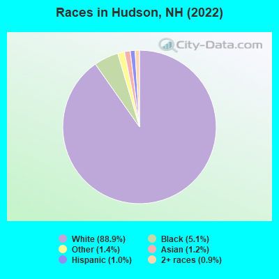
- 6,28288.9%White alone
- 3575.1%Black alone
- 1001.4%Other race alone
- 871.2%Asian alone
- 711.0%Hispanic
- 670.9%Two or more races
Races in Hudson detailed stats: ancestries, foreign born residents, place of birth
According to our research of New Hampshire and other state lists, there were 25 registered sex offenders living in Hudson, New Hampshire as of May 03, 2024.
The ratio of all residents to sex offenders in Hudson is 321 to 1.
Type |
2009 |
2010 |
2011 |
2012 |
2013 |
2014 |
2015 |
2016 |
2017 |
2018 |
2019 |
2020 |
2021 |
2022 |
|---|---|---|---|---|---|---|---|---|---|---|---|---|---|---|
| Murders (per 100,000) | 0 (0.0) | 0 (0.0) | 0 (0.0) | 0 (0.0) | 0 (0.0) | 0 (0.0) | 0 (0.0) | 0 (0.0) | 0 (0.0) | 0 (0.0) | 0 (0.0) | 0 (0.0) | 0 (0.0) | 1 (3.9) |
| Rapes (per 100,000) | 7 (28.0) | 5 (20.4) | 4 (16.3) | 6 (24.4) | 10 (40.7) | 7 (28.4) | 11 (44.3) | 5 (20.0) | 9 (35.7) | 3 (11.9) | 3 (11.7) | 9 (35.0) | 13 (50.5) | 10 (39.2) |
| Robberies (per 100,000) | 5 (20.0) | 2 (8.2) | 7 (28.6) | 5 (20.3) | 8 (32.5) | 5 (20.3) | 3 (12.1) | 5 (20.0) | 1 (4.0) | 3 (11.9) | 2 (7.8) | 6 (23.3) | 3 (11.7) | 2 (7.8) |
| Assaults (per 100,000) | 29 (116.1) | 23 (94.0) | 18 (73.5) | 19 (77.3) | 23 (93.5) | 20 (81.0) | 21 (84.5) | 30 (120.0) | 17 (67.4) | 19 (75.3) | 14 (54.5) | 7 (27.2) | 8 (31.1) | 3 (11.8) |
| Burglaries (per 100,000) | 62 (248.2) | 76 (310.6) | 60 (244.9) | 68 (276.7) | 65 (264.3) | 63 (255.2) | 45 (181.1) | 30 (120.0) | 28 (111.1) | 27 (107.0) | 28 (109.0) | 23 (89.3) | 21 (81.6) | 14 (54.8) |
| Thefts (per 100,000) | 319 (1,277) | 302 (1,234) | 288 (1,176) | 336 (1,367) | 297 (1,208) | 351 (1,422) | 261 (1,050) | 253 (1,012) | 209 (829.0) | 205 (812.5) | 174 (677.2) | 177 (687.4) | 158 (613.9) | 177 (693.3) |
| Auto thefts (per 100,000) | 22 (88.1) | 30 (122.6) | 19 (77.6) | 20 (81.4) | 9 (36.6) | 16 (64.8) | 15 (60.4) | 23 (92.0) | 13 (51.6) | 15 (59.4) | 9 (35.0) | 13 (50.5) | 19 (73.8) | 12 (47.0) |
| Arson (per 100,000) | 3 (12.0) | 9 (36.8) | 3 (12.2) | 4 (16.3) | 4 (16.3) | 1 (4.1) | 3 (12.1) | 0 (0.0) | 2 (7.9) | 1 (4.0) | 1 (3.9) | 3 (11.7) | 1 (3.9) | 1 (3.9) |
| City-Data.com crime index | 127.2 | 118.5 | 106.7 | 121.7 | 130.7 | 124.9 | 115.5 | 102.3 | 88.3 | 72.9 | 60.1 | 78.2 | 86.3 | 79.2 |
The City-Data.com crime index weighs serious crimes and violent crimes more heavily. Higher means more crime, U.S. average is 246.1. It adjusts for the number of visitors and daily workers commuting into cities.

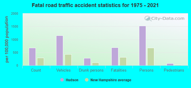
Crime rate in Hudson detailed stats: murders, rapes, robberies, assaults, burglaries, thefts, arson
Full-time law enforcement employees in 2021, including police officers: 67 (50 officers - 42 male; 8 female).
| Officers per 1,000 residents here: | 1.94 |
| New Hampshire average: | 2.14 |
 Recent articles from our blog. Our writers, many of them Ph.D. graduates or candidates, create easy-to-read articles on a wide variety of topics.

 | Another "hydropower" Power Line Project (5 replies) |
| Hudson Range (4 replies) |
| Thoughts on Hudson and Merrimack? (1 reply) |
| Does Hudson NH school system offer free preschool? Thoughts on Hudson schools? (4 replies) |
| bridge connecting hudson and nashua (8 replies) |
| Thoughts on HUDSON NH (2 replies) |
Latest news from Hudson, NH collected exclusively by city-data.com from local newspapers, TV, and radio stations
Ancestries: Irish (18.7%), English (18.6%), French (13.3%), French Canadian (10.3%), Italian (9.3%), Liberian (3.8%).
Current Local Time: EST time zone
Incorporated in 1746
Land area: 3.06 square miles.
Population density: 2,394 people per square mile (low).
466 residents are foreign born (3.9% Africa, 1.5% Asia).
| This place: | 6.6% |
| New Hampshire: | 6.0% |
Median real estate property taxes paid for housing units with mortgages in 2022: $5,427 (1.6%)
Median real estate property taxes paid for housing units with no mortgage in 2022: $4,516 (1.5%)
Nearest city with pop. 50,000+: Nashua, NH  (2.6 miles , pop. 86,605).
Nearest city with pop. 200,000+: Boston, MA (35.1 miles , pop. 589,141).
Nearest city with pop. 1,000,000+: Bronx, NY (182.7 miles , pop. 1,332,650).
Nearest cities:
), ), ), ), Latitude: 42.76 N, Longitude: 71.43 W
Daytime population change due to commuting: -1,904 (-26.9%)
Workers who live and work in this place: 586 (13.4%)
Area code commonly used in this area: 603
Hudson, New Hampshire accommodation & food services, waste management - Economy and Business Data
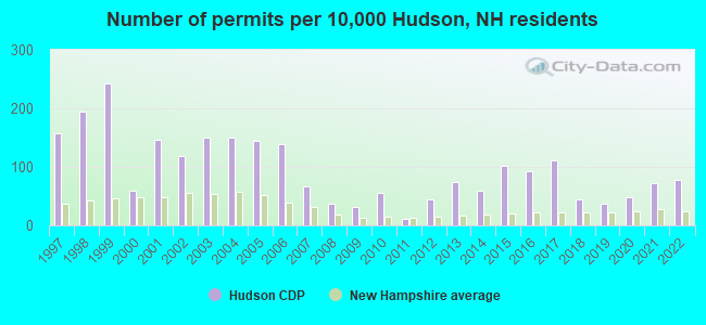
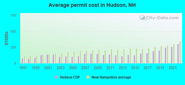
Single-family new house construction building permits:
- 2022: 61 buildings, average cost: $306,300
- 2021: 57 buildings, average cost: $259,600
- 2020: 38 buildings, average cost: $248,100
- 2019: 29 buildings, average cost: $205,700
- 2018: 34 buildings, average cost: $194,400
- 2017: 87 buildings, average cost: $165,000
- 2016: 72 buildings, average cost: $156,200
- 2015: 80 buildings, average cost: $128,200
- 2014: 47 buildings, average cost: $131,900
- 2013: 58 buildings, average cost: $117,300
- 2012: 34 buildings, average cost: $129,100
- 2011: 9 buildings, average cost: $143,300
- 2010: 44 buildings, average cost: $133,400
- 2009: 24 buildings, average cost: $149,600
- 2008: 29 buildings, average cost: $156,100
- 2007: 52 buildings, average cost: $152,700
- 2006: 108 buildings, average cost: $113,700
- 2005: 113 buildings, average cost: $109,300
- 2004: 117 buildings, average cost: $109,800
- 2003: 117 buildings, average cost: $105,300
- 2002: 92 buildings, average cost: $140,600
- 2001: 114 buildings, average cost: $142,300
- 2000: 47 buildings, average cost: $133,000
- 1999: 190 buildings, average cost: $87,100
- 1998: 152 buildings, average cost: $75,600
- 1997: 123 buildings, average cost: $77,800
| Here: | 2.6% |
| New Hampshire: | 2.5% |
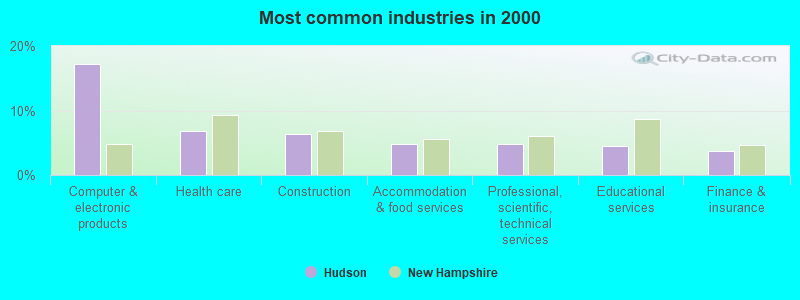
- Computer & electronic products (17.3%)
- Health care (6.8%)
- Construction (6.4%)
- Accommodation & food services (4.8%)
- Professional, scientific, technical services (4.7%)
- Educational services (4.4%)
- Finance & insurance (3.7%)
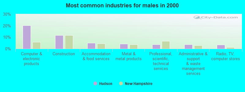
- Computer & electronic products (20.1%)
- Construction (11.7%)
- Accommodation & food services (5.0%)
- Metal & metal products (4.2%)
- Professional, scientific, technical services (3.8%)
- Administrative & support & waste management services (3.6%)
- Radio, TV, computer stores (3.5%)
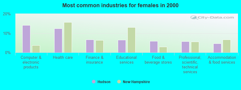
- Computer & electronic products (14.1%)
- Health care (12.5%)
- Finance & insurance (6.7%)
- Educational services (6.4%)
- Food & beverage stores (6.0%)
- Professional, scientific, technical services (5.8%)
- Accommodation & food services (4.6%)
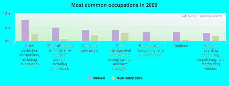
- Other production occupations, including supervisors (7.7%)
- Other office and administrative support workers, including supervisors (5.0%)
- Computer specialists (4.1%)
- Other management occupations, except farmers and farm managers (4.0%)
- Bookkeeping, accounting, and auditing clerks (3.3%)
- Cashiers (3.2%)
- Material recording, scheduling, dispatching, and distributing workers (3.1%)
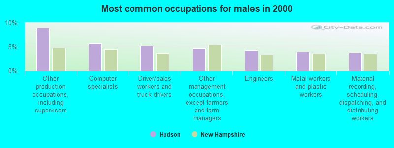
- Other production occupations, including supervisors (9.0%)
- Computer specialists (5.6%)
- Driver/sales workers and truck drivers (5.1%)
- Other management occupations, except farmers and farm managers (4.6%)
- Engineers (4.2%)
- Metal workers and plastic workers (4.0%)
- Material recording, scheduling, dispatching, and distributing workers (3.7%)
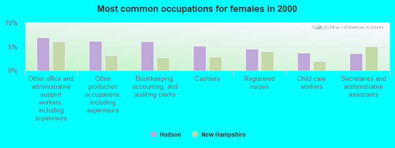
- Other office and administrative support workers, including supervisors (6.9%)
- Other production occupations, including supervisors (6.2%)
- Bookkeeping, accounting, and auditing clerks (6.1%)
- Cashiers (5.2%)
- Registered nurses (4.5%)
- Child care workers (3.7%)
- Secretaries and administrative assistants (3.6%)
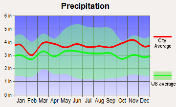
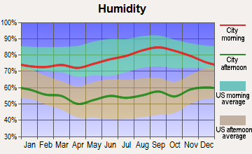
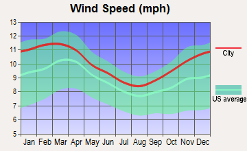
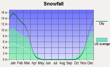
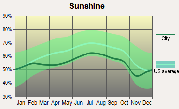
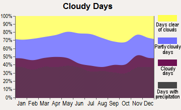
Average climate in Hudson, New Hampshire
Based on data reported by over 4,000 weather stations

|
|


(lower is better)
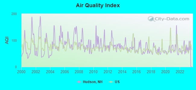
Air Quality Index (AQI) level in 2022 was 66.7. This is about average.
| City: | 66.7 |
| U.S.: | 72.6 |
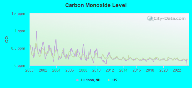
Carbon Monoxide (CO) [ppm] level in 2022 was 0.155. This is significantly better than average. Closest monitor was 1.7 miles away from the city center.
| City: | 0.155 |
| U.S.: | 0.251 |
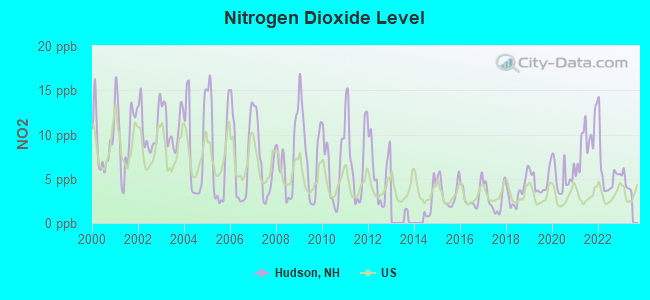
Nitrogen Dioxide (NO2) [ppb] level in 2022 was 5.65. This is about average. Closest monitor was 1.7 miles away from the city center.
| City: | 5.65 |
| U.S.: | 5.11 |
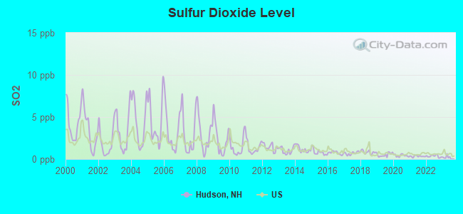
Sulfur Dioxide (SO2) [ppb] level in 2022 was 0.343. This is significantly better than average. Closest monitor was 1.7 miles away from the city center.
| City: | 0.343 |
| U.S.: | 1.515 |
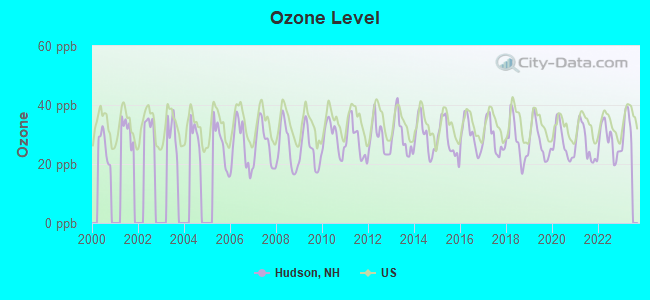
Ozone [ppb] level in 2022 was 27.9. This is about average. Closest monitor was 1.7 miles away from the city center.
| City: | 27.9 |
| U.S.: | 33.3 |
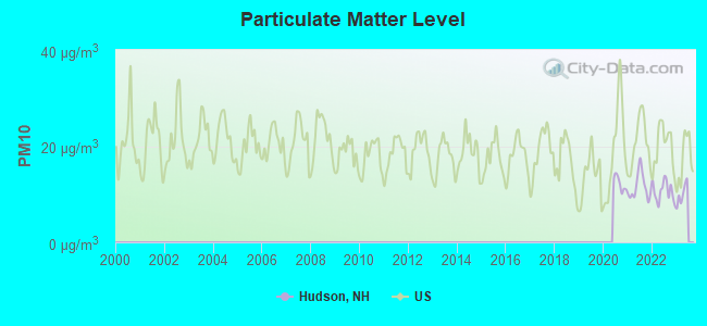
Particulate Matter (PM10) [µg/m3] level in 2022 was 10.6. This is significantly better than average. Closest monitor was 1.7 miles away from the city center.
| City: | 10.6 |
| U.S.: | 19.2 |
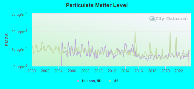
Particulate Matter (PM2.5) [µg/m3] level in 2022 was 5.87. This is better than average. Closest monitor was 0.6 miles away from the city center.
| City: | 5.87 |
| U.S.: | 8.11 |
Tornado activity:
Hudson-area historical tornado activity is above New Hampshire state average. It is 32% smaller than the overall U.S. average.
On 6/9/1953, a category F4 (max. wind speeds 207-260 mph) tornado 32.3 miles away from the Hudson place center killed 90 people and injured 1228 people and caused between $50,000,000 and $500,000,000 in damages.
On 10/3/1970, a category F3 (max. wind speeds 158-206 mph) tornado 14.0 miles away from the place center killed one person and caused between $50,000 and $500,000 in damages.
Earthquake activity:
Hudson-area historical earthquake activity is significantly above New Hampshire state average. It is 72% smaller than the overall U.S. average.On 4/20/2002 at 10:50:47, a magnitude 5.3 (5.3 ML, Depth: 3.0 mi, Class: Moderate, Intensity: VI - VII) earthquake occurred 165.9 miles away from Hudson center
On 10/7/1983 at 10:18:46, a magnitude 5.3 (5.1 MB, 5.3 LG, 5.1 ML) earthquake occurred 167.9 miles away from the city center
On 1/19/1982 at 00:14:42, a magnitude 4.7 (4.5 MB, 4.7 MD, 4.5 LG, Class: Light, Intensity: IV - V) earthquake occurred 51.7 miles away from the city center
On 4/20/2002 at 10:50:47, a magnitude 5.2 (5.2 MB, 4.2 MS, 5.2 MW, 5.0 MW) earthquake occurred 165.3 miles away from Hudson center
On 10/16/2012 at 23:12:25, a magnitude 4.7 (4.7 ML, Depth: 10.0 mi) earthquake occurred 69.8 miles away from the city center
On 8/22/1992 at 12:20:32, a magnitude 4.8 (4.8 MB, 3.8 MS, 4.7 LG, Depth: 6.2 mi) earthquake occurred 259.5 miles away from the city center
Magnitude types: regional Lg-wave magnitude (LG), body-wave magnitude (MB), duration magnitude (MD), local magnitude (ML), surface-wave magnitude (MS), moment magnitude (MW)
Natural disasters:
The number of natural disasters in Hillsborough County (27) is a lot greater than the US average (15).Major Disasters (Presidential) Declared: 17
Emergencies Declared: 10
Causes of natural disasters: Storms: 13, Floods: 11, Winter Storms: 5, Snowstorms: 4, Hurricanes: 3, Snows: 3, Blizzard: 1, Ice Storm: 1, Snowfall: 1, Wind: 1 (Note: some incidents may be assigned to more than one category).
Main business address for: PRESSTEK INC /DE/ (PRINTING TRADES MACHINERY & EQUIPMENT).
Hospitals and medical centers in Hudson:
Other hospitals and medical centers near Hudson:
- NASHUA DIALYSIS (Dialysis Facility, about 2 miles away; NASHUA, NH)
- SOUTHERN NH MEDICAL CENTER Acute Care Hospitals (about 2 miles away; NASHUA, NH)
- HEALTHY AT HOME (Home Health Center, about 2 miles away; NASHUA, NH)
- COURVILLE AT NASHUA (Nursing Home, about 3 miles away; NASHUA, NH)
- ST JOSEPH HOSPITAL Acute Care Hospitals (about 3 miles away; NASHUA, NH)
- KINDRED TRANSITIONAL CARE AND REHABILITATION-GREENBR (Nursing Home, about 4 miles away; NASHUA, NH)
- BEACON HOSPICE INC (Hospital, about 4 miles away; NASHUA, NH)
Colleges/Universities in Hudson:
Colleges/universities with over 2000 students nearest to Hudson:
- University of Massachusetts-Lowell (about 10 miles; Lowell, MA; Full-time enrollment: 12,341)
- Mount Washington College (about 15 miles; Manchester, NH; FT enrollment: 2,187)
- Saint Anselm College (about 16 miles; Manchester, NH; FT enrollment: 2,059)
- Merrimack College (about 17 miles; North Andover, MA; FT enrollment: 2,734)
- Middlesex Community College (about 19 miles; Bedford, MA; FT enrollment: 6,040)
- Southern New Hampshire University (about 20 miles; Manchester, NH; FT enrollment: 16,552)
- Northern Essex Community College (about 20 miles; Haverhill, MA; FT enrollment: 4,737)
Public high school in Hudson:
- ALVIRNE HIGH SCHOOL (Students: 1,554, Location: 200 DERRY RD., Grades: 9-12)
Public elementary/middle schools in Hudson:
- HUDSON MEMORIAL SCHOOL (Students: 1,026, Location: 1 MEMORIAL DR., Grades: 6-8)
- NOTTINGHAM WEST ELEMENTARY SCHOOL (Students: 691, Location: 10 PELHAM RD., Grades: 2-5)
- HILLS GARRISON ELEMENTARY SCHOOL (Students: 470, Location: 190 DERRY RD., Grades: 2-5)
- DR. H. O. SMITH ELEMENTARY SCHOOL (Students: 211, Location: 33 SCHOOL ST., Grades: PK-1)
Private elementary/middle school in Hudson:
- PRESENTATION OF MARY ACADEMY (Students: 468, Location: 182 LOWELL RD, Grades: PK-8)
Points of interest:
Notable locations in Hudson: Hudson Chamber of Commerce (A), Hudson New Hampshire Fire Department Central Station Headquarters (B), Hills Memorial Library (C). Display/hide their locations on the map
Shopping Center: Hudson Mall Shopping Center (1). Display/hide its location on the map
Churches in Hudson include: United Pentecostal Church (A), Heritage Baptist Church (B), Hudson Community Church (C), Saint John the Evangelist Roman Catholic Church (D), First Baptist Church of Hudson (E), Hudson Community United Church of Christ (F). Display/hide their locations on the map
Cemeteries: Sunnyside Cemetery (1), Westview Cemetery (2), Polish Cemetery (3), Saint Patricks Cemetery (4). Display/hide their locations on the map
Lakes: Little Ottarnic Pond (A), Melendys Pond (B), Ottarnic Pond (C). Display/hide their locations on the map
Streams, rivers, and creeks: Second Brook (A), Reeds Brook (B), Merrill Brook (C), Glover Brook (D), First Brook (E). Display/hide their locations on the map
Park in Hudson: Lyons Field (1). Display/hide its location on the map
Tourist attraction: Mark & Brenda's House of Games (Arcades & Amusements; 77 Lowell Road).
Hotels: Days Inn (90 Derry Street), Nashua-Days Inn Hudson (90 Derry St).
Court: Kings Court & Banquet Hall (222 Central).
Drinking water stations with addresses in Hudson and their reported violations in the past:
HUDSON WATER DEPT (Population served: 16,000, Groundwater):Past monitoring violations:LITCHFIELD LANDING (Population served: 78, Groundwater):
- Monitoring and Reporting (DBP) - Between JUL-01-2010 and OCT-01-2010, Contaminant: Chlorine. Follow-up actions: St Violation/Reminder Notice (OCT-29-2010), St Compliance achieved (MAR-16-2011)
Past health violations:PARADISE ESTATES (Population served: 32, Groundwater):Past monitoring violations:
- MCL, Monthly (TCR) - In OCT-2007, Contaminant: Coliform. Follow-up actions: St Public Notif requested (OCT-24-2007), St Violation/Reminder Notice (OCT-24-2007), St Public Notif received (NOV-09-2007), St Compliance achieved (MAY-07-2008)
- One routine major monitoring violation
Past health violations:WAUMBEK GOLF COURSE (Population served: 30, Groundwater):
- MCL, Monthly (TCR) - In FEB-2014, Contaminant: Coliform. Follow-up actions: St Public Notif requested (FEB-24-2014), St Violation/Reminder Notice (FEB-24-2014), St Public Notif received (MAR-24-2014)
- MCL, Monthly (TCR) - In JAN-2014, Contaminant: Coliform. Follow-up actions: St Public Notif requested (JAN-21-2014), St Violation/Reminder Notice (JAN-21-2014), St Public Notif received (FEB-05-2014)
- MCL, Monthly (TCR) - In NOV-2013, Contaminant: Coliform. Follow-up actions: St Public Notif requested (NOV-18-2013), St Violation/Reminder Notice (NOV-18-2013), St Public Notif received (NOV-25-2013)
Past monitoring violations:
- One routine major monitoring violation
Drinking water stations with addresses in Hudson that have no violations reported:
- FRANCOEUR APT/HUDSON MOTOR INN (Population served: 96, Primary Water Source Type: Groundwater)
| This place: | 2.5 people |
| New Hampshire: | 2.5 people |
| This place: | 67.3% |
| Whole state: | 66.3% |
| This place: | 8.4% |
| Whole state: | 8.3% |
Likely homosexual households (counted as self-reported same-sex unmarried-partner households)
- Lesbian couples: 0.6% of all households
- Gay men: 0.3% of all households
Banks with branches in Hudson (2011 data):
- RBS Citizens, National Association: Hudson S&S Nh Branch at 9 Wason Road, branch established on 2004/10/07; Hudson Branch at 71 Lowell Road, branch established on 1964/08/24. Info updated 2007/09/19: Bank assets: $106,940.6 mil, Deposits: $75,690.2 mil, headquarters in Providence, RI, positive income, 1135 total offices, Holding Company: Uk Financial Investments Limited
- Sovereign Bank, National Association: Hudson Branch at 15 Ferry Street, branch established on 1963/10/14. Info updated 2012/01/31: Bank assets: $78,146.9 mil, Deposits: $48,042.9 mil, headquarters in Wilmington, DE, positive income, Commercial Lending Specialization, 718 total offices, Holding Company: Banco Santander, S.A.
- TD Bank, National Association: Hudson Branch at 80 Derry Rd, branch established on 1971/01/18. Info updated 2010/10/04: Bank assets: $188,912.6 mil, Deposits: $153,149.8 mil, headquarters in Wilmington, DE, positive income, 1314 total offices, Holding Company: Toronto-Dominion Bank, The
- Bank of America, National Association: Alvirne High School Branch at Alvirne High School Vocational Education Center, branch established on 1992/10/19. Info updated 2009/11/18: Bank assets: $1,451,969.3 mil, Deposits: $1,077,176.8 mil, headquarters in Charlotte, NC, positive income, 5782 total offices, Holding Company: Bank Of America Corporation
- Enterprise Bank and Trust Company: Hudson Nh Branch at 45 Lowell Road, branch established on 2011/01/31. Info updated 2006/11/03: Bank assets: $1,488.4 mil, Deposits: $1,333.6 mil, headquarters in Lowell, MA, positive income, Commercial Lending Specialization, 20 total offices, Holding Company: Enterprise Bancorp, Inc.
For population 15 years and over in Hudson:
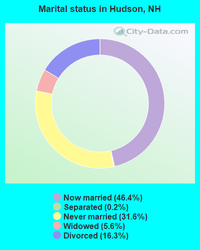
- Never married: 31.6%
- Now married: 46.4%
- Separated: 0.2%
- Widowed: 5.6%
- Divorced: 16.3%
For population 25 years and over in Hudson:
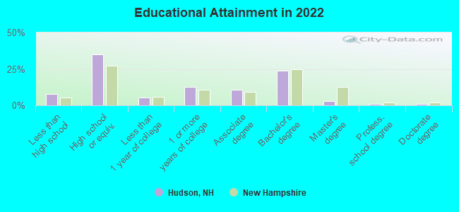
- High school or higher: 92.6%
- Bachelor's degree or higher: 29.1%
- Graduate or professional degree: 4.7%
- Unemployed: 3.3%
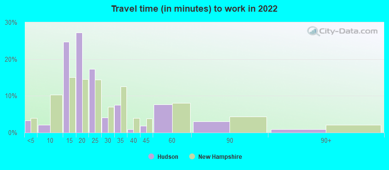
- Mean travel time to work (commute): 28.4 minutes
| Here: | 8.5 |
| New Hampshire average: | 10.3 |


Graphs represent county-level data. Detailed 2008 Election Results
Religion statistics for Hudson, NH (based on Hillsborough County data)


| Religion | Adherents | Congregations |
|---|---|---|
| Catholic | 124,993 | 40 |
| Evangelical Protestant | 20,588 | 103 |
| Mainline Protestant | 17,794 | 60 |
| Other | 7,365 | 35 |
| Orthodox | 2,990 | 7 |
| Black Protestant | - | 1 |
| None | 226,991 | - |
Food Environment Statistics:
| Hillsborough County: | 1.82 / 10,000 pop. |
| State: | 2.14 / 10,000 pop. |
| This county: | 0.12 / 10,000 pop. |
| New Hampshire: | 0.15 / 10,000 pop. |
| This county: | 1.65 / 10,000 pop. |
| New Hampshire: | 1.78 / 10,000 pop. |
| Hillsborough County: | 2.67 / 10,000 pop. |
| New Hampshire: | 4.02 / 10,000 pop. |
| Hillsborough County: | 8.23 / 10,000 pop. |
| New Hampshire: | 9.70 / 10,000 pop. |
| Hillsborough County: | 6.9% |
| New Hampshire: | 7.6% |
| Hillsborough County: | 24.5% |
| New Hampshire: | 24.4% |
| This county: | 15.1% |
| New Hampshire: | 15.9% |
Health and Nutrition:
| Here: | 49.9% |
| New Hampshire: | 51.2% |
| Hudson: | 48.1% |
| New Hampshire: | 49.1% |
| This city: | 29.0 |
| State: | 28.5 |
| Hudson: | 21.7% |
| State: | 20.9% |
| Here: | 10.0% |
| New Hampshire: | 9.3% |
| This city: | 6.8 |
| New Hampshire: | 6.9 |
| Here: | 35.8% |
| State: | 34.3% |
| Here: | 58.0% |
| State: | 58.1% |
| Here: | 79.5% |
| New Hampshire: | 79.1% |
More about Health and Nutrition of Hudson, NH Residents
6.73% of this county's 2021 resident taxpayers lived in other counties in 2020 ($92,767 average adjusted gross income)
| Here: | 6.73% |
| New Hampshire average: | 7.66% |
0.01% of residents moved from foreign countries ($183 average AGI)
Hillsborough County: 0.01% New Hampshire average: 0.01%
Top counties from which taxpayers relocated into this county between 2020 and 2021:
| from Middlesex County, MA | |
| from Rockingham County, NH | |
| from Merrimack County, NH |
6.49% of this county's 2020 resident taxpayers moved to other counties in 2021 ($81,100 average adjusted gross income)
| Here: | 6.49% |
| New Hampshire average: | 6.80% |
0.02% of residents moved to foreign countries ($105 average AGI)
Hillsborough County: 0.02% New Hampshire average: 0.01%
Top counties to which taxpayers relocated from this county between 2020 and 2021:
| to Rockingham County, NH | |
| to Merrimack County, NH | |
| to Middlesex County, MA |
| Businesses in Hudson, NH | ||||
| Name | Count | Name | Count | |
|---|---|---|---|---|
| 7-Eleven | 2 | Pizza Hut | 1 | |
| Burger King | 2 | RadioShack | 1 | |
| CVS | 1 | Rite Aid | 2 | |
| Circle K | 1 | Sam's Club | 1 | |
| Curves | 1 | Sears | 1 | |
| DHL | 2 | Subaru | 1 | |
| Dairy Queen | 1 | Subway | 2 | |
| Domino's Pizza | 1 | T-Mobile | 2 | |
| Dunkin Donuts | 4 | The Room Place | 1 | |
| Fashion Bug | 1 | True Value | 1 | |
| FedEx | 3 | U-Haul | 2 | |
| GNC | 2 | UPS | 3 | |
| H&R Block | 1 | Vans | 1 | |
| MasterBrand Cabinets | 14 | Walgreens | 1 | |
| McDonald's | 2 | Walmart | 1 | |
| Penske | 1 | |||
Strongest AM radio stations in Hudson:
- WSMN (1590 AM; 5 kW; NASHUA, NH; Owner: 1590 BROADCASTING CORP.)
- WSNH (900 AM; 1 kW; NASHUA, NH; Owner: ANASTOS MEDIA GROUP, INC.)
- WRKO (680 AM; 50 kW; BOSTON, MA; Owner: ENTERCOM BOSTON LICENSE, LLC)
- WCAP (980 AM; 5 kW; LOWELL, MA; Owner: NORTHEAST RADIO, INC.)
- WDER (1320 AM; 10 kW; DERRY, NH; Owner: BLOUNT COMMUNICATIONS, INC. OF NH)
- WCEC (1110 AM; daytime; 5 kW; SALEM, NH; Owner: COSTA-EAGLE RADIO VENTURES LTD PARTNERSHIP)
- WEEI (850 AM; 50 kW; BOSTON, MA; Owner: ENTERCOM BOSTON LICENSE, LLC)
- WWZN (1510 AM; 50 kW; BOSTON, MA; Owner: ROSE CITY RADIO CORPORATION)
- WKOX (1200 AM; 50 kW; FRAMINGHAM, MA; Owner: CAPSTAR TX LIMITED PARTNERSHIP)
- WFEA (1370 AM; 5 kW; MANCHESTER, NH; Owner: SAGA COMMUNICATIONS OF NEW ENGLAND, LLC)
- WBIX (1060 AM; 40 kW; NATICK, MA; Owner: LANGER BROADCASTING CORPORATION)
- WCRN (830 AM; 50 kW; WORCESTER, MA; Owner: CARTER BROADCASTING CORPORATION)
- WBZ (1030 AM; 50 kW; BOSTON, MA; Owner: INFINITY BROADCASTING OPERATIONS, INC.)
Strongest FM radio stations in Hudson:
- WHOB (106.3 FM; NASHUA, NH; Owner: TELE-MEDIA COMPANY OF NEW HAMPSHIRE, L.L.C.)
- WGIR-FM (101.1 FM; MANCHESTER, NH; Owner: CAPSTAR TX LIMITED PARTNERSHIP)
- WQLL (96.5 FM; BEDFORD, NH; Owner: SAGA COMMUNICATIONS OF NEW ENGLAND, LLC)
- WLMW (90.7 FM; MANCHESTER, NH; Owner: KNOWLEDGE FOR LIFE)
- WKLB-FM (99.5 FM; LOWELL, MA; Owner: GREATER BOSTON RADIO, INC.)
- WZID (95.7 FM; MANCHESTER, NH; Owner: SAGA COMMUNICATIONS OF NEW ENGLAND, LLC)
- WFEX (92.1 FM; PETERBOROUGH, NH; Owner: FNX BROADCASTING OF NEW HAMPSHIRE LLC)
- W227AM (93.3 FM; ANDOVER, MA; Owner: GREATER BOSTON RADIO, INC.)
- WXRV (92.5 FM; HAVERHILL, MA; Owner: BEANPOT BROADCASTING CORP.)
- WBMX (98.5 FM; BOSTON, MA; Owner: INFINITY RADIO OPERATIONS INC.)
- WXKS-FM (107.9 FM; MEDFORD, MA; Owner: AMFM RADIO LICENSES, L.L.C.)
- WJMN (94.5 FM; BOSTON, MA; Owner: AMFM RADIO LICENSES, L.L.C.)
- WCRB (102.5 FM; WALTHAM, MA; Owner: CHARLES RIVER BROADCASTING WCRB LICE)
- WTKK (96.9 FM; BOSTON, MA; Owner: GREATER BOSTON RADIO, INC.)
- WROR-FM (105.7 FM; FRAMINGHAM, MA; Owner: GREATER BOSTON RADIO, INC.)
- WBOS (92.9 FM; BROOKLINE, MA; Owner: GREATER BOSTON RADIO, INC.)
- WMJX (106.7 FM; BOSTON, MA; Owner: GREATER BOSTON RADIO, INC.)
- WJUL (91.5 FM; LOWELL, MA; Owner: UNIVERSITY OF MASSACHUSETTS, LOWELL)
- WGBH (89.7 FM; BOSTON, MA; Owner: WGBH EDUCATIONAL FOUNDATION)
- WBUR-FM (90.9 FM; BOSTON, MA; Owner: TRUSTEES OF BOSTON UNIVERSITY)
TV broadcast stations around Hudson:
- WNDS (Channel 50; DERRY, NH; Owner: CTV OF DERRY, INC)
- WYCN-LP (Channel 13; NASHUA, NH; Owner: CENTER BROADCASTING CORP. OF NEW HAMPSHIRE)
- W33AK (Channel 33; NASHUA, NH; Owner: CENTER B/CING CORPORATION OF NEW HAMPSHIRE)
- WFXZ-CA (Channel 24; BOSTON, MA; Owner: BOSTON BROADCASTING CORP.)
- WCVB-TV (Channel 5; BOSTON, MA; Owner: WCVB HEARST-ARGYLE TV, INC.)
- WUTF (Channel 66; MARLBOROUGH, MA; Owner: TELEFUTURA BOSTON LLC)
- WGBH-TV (Channel 2; BOSTON, MA; Owner: WGBH EDUCATIONAL FOUNDATION)
- WHDH-TV (Channel 7; BOSTON, MA; Owner: WHDH-TV)
- WUNI (Channel 27; WORCESTER, MA; Owner: ENTRAVISION HOLDINGS, LLC)
- WMFP (Channel 62; LAWRENCE, MA; Owner: WSAH LICENSE, INC.)
- WBZ-TV (Channel 4; BOSTON, MA; Owner: VIACOM INC.)
- WGBX-TV (Channel 44; BOSTON, MA; Owner: WGBH EDUCATIONAL FOUNDATION)
- WSBK-TV (Channel 38; BOSTON, MA; Owner: VIACOM INC.)
- WLVI-TV (Channel 56; CAMBRIDGE, MA; Owner: WLVI, INC.)
- WFXT (Channel 25; BOSTON, MA; Owner: FOX TELEVISION STATIONS INC.)
- WBPX (Channel 68; BOSTON, MA; Owner: PAXSON BOSTON-68 LICENSE, INC.)
- WHDN-LP (Channel 26; BOSTON, MA; Owner: GUENTER MARKSTEINER)
- W40BO (Channel 40; BOSTON, MA; Owner: PAXSON COMMUNICATIONS LPTV, INC.)
- WMEA-TV (Channel 26; BIDDEFORD, ME; Owner: MAINE PUBLIC BROADCASTING CORP.)
- WTMU-LP (Channel 32; BOSTON, MA; Owner: ZGS BOSTON, INC.)
- WCEA-LP (Channel 58; BOSTON, MA; Owner: CHANNEL 19 TV CORPORATION)
- WMUR-TV (Channel 9; MANCHESTER, NH; Owner: HEARST-ARGYLE PROPERTIES, INC.)
- W29AT (Channel 29; MANCHESTER, NH; Owner: CENTER BROADCASTING CORP. OF NEW HAMPSHIRE)
FCC Registered Antenna Towers: 28 (See the full list of FCC Registered Antenna Towers)
FCC Registered Commercial Land Mobile Towers: 1 (See the full list of FCC Registered Commercial Land Mobile Towers in Hudson, NH)
FCC Registered Private Land Mobile Towers: 16 (See the full list of FCC Registered Private Land Mobile Towers)
FCC Registered Broadcast Land Mobile Towers: 11 (See the full list of FCC Registered Broadcast Land Mobile Towers)
FCC Registered Microwave Towers: 8 (See the full list of FCC Registered Microwave Towers in this town)
FCC Registered Paging Towers: 9 (See the full list of FCC Registered Paging Towers)
FCC Registered Maritime Coast & Aviation Ground Towers: 2 (See the full list of FCC Registered Maritime Coast & Aviation Ground Towers)
FCC Registered Amateur Radio Licenses: 242 (See the full list of FCC Registered Amateur Radio Licenses in Hudson)
FAA Registered Aircraft Manufacturers and Dealers: 1 (See the full list of FAA Registered Manufacturers and Dealers in Hudson)
FAA Registered Aircraft: 18 (See the full list of FAA Registered Aircraft)
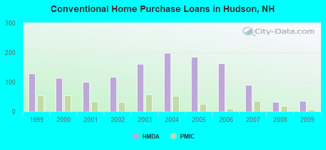
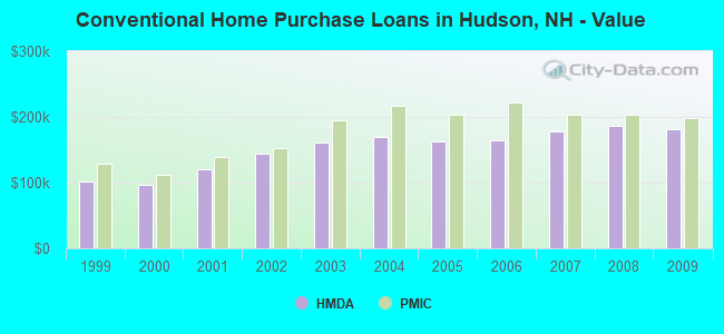
| Home Mortgage Disclosure Act Aggregated Statistics For Year 2009 (Based on 1 full tract) | ||||||||||||||
| A) FHA, FSA/RHS & VA Home Purchase Loans | B) Conventional Home Purchase Loans | C) Refinancings | D) Home Improvement Loans | E) Loans on Dwellings For 5+ Families | F) Non-occupant Loans on < 5 Family Dwellings (A B C & D) | G) Loans On Manufactured Home Dwelling (A B C & D) | ||||||||
|---|---|---|---|---|---|---|---|---|---|---|---|---|---|---|
| Number | Average Value | Number | Average Value | Number | Average Value | Number | Average Value | Number | Average Value | Number | Average Value | Number | Average Value | |
| LOANS ORIGINATED | 49 | $178,102 | 35 | $182,029 | 179 | $179,358 | 8 | $42,500 | 1 | $525,000 | 13 | $165,615 | 0 | $0 |
| APPLICATIONS APPROVED, NOT ACCEPTED | 3 | $113,000 | 1 | $134,000 | 14 | $186,786 | 1 | $15,000 | 0 | $0 | 0 | $0 | 0 | $0 |
| APPLICATIONS DENIED | 4 | $221,500 | 10 | $133,700 | 86 | $197,000 | 17 | $71,824 | 0 | $0 | 5 | $138,400 | 4 | $53,500 |
| APPLICATIONS WITHDRAWN | 1 | $164,000 | 6 | $166,667 | 47 | $199,064 | 2 | $3,500 | 0 | $0 | 2 | $104,500 | 2 | $52,500 |
| FILES CLOSED FOR INCOMPLETENESS | 1 | $194,000 | 2 | $127,000 | 10 | $215,400 | 0 | $0 | 0 | $0 | 0 | $0 | 1 | $90,000 |
Detailed HMDA statistics for the following Tracts: 0122.00
| Private Mortgage Insurance Companies Aggregated Statistics For Year 2009 (Based on 1 full tract) | ||||||||
| A) Conventional Home Purchase Loans | B) Refinancings | C) Non-occupant Loans on < 5 Family Dwellings (A & B) | D) Loans On Manufactured Home Dwelling (A & B) | |||||
|---|---|---|---|---|---|---|---|---|
| Number | Average Value | Number | Average Value | Number | Average Value | Number | Average Value | |
| LOANS ORIGINATED | 7 | $198,143 | 2 | $180,500 | 0 | $0 | 1 | $90,000 |
| APPLICATIONS APPROVED, NOT ACCEPTED | 1 | $234,000 | 3 | $237,333 | 0 | $0 | 0 | $0 |
| APPLICATIONS DENIED | 1 | $221,000 | 2 | $170,000 | 0 | $0 | 0 | $0 |
| APPLICATIONS WITHDRAWN | 0 | $0 | 0 | $0 | 0 | $0 | 0 | $0 |
| FILES CLOSED FOR INCOMPLETENESS | 2 | $243,000 | 0 | $0 | 1 | $252,000 | 0 | $0 |
Detailed PMIC statistics for the following Tracts: 0122.00
2003 - 2018 National Fire Incident Reporting System (NFIRS) incidents
- Fire incident types reported to NFIRS in Hudson, NH
- 29543.8%Structure Fires
- 22433.2%Outside Fires
- 9914.7%Mobile Property/Vehicle Fires
- 568.3%Other
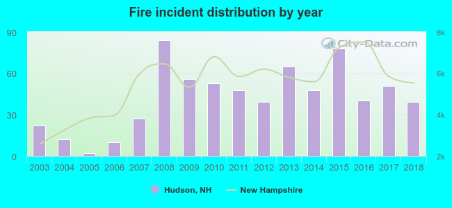 According to the data from the years 2003 - 2018 the average number of fires per year is 42. The highest number of fire incidents - 84 took place in 2008, and the least - 2 in 2005. The data has a growing trend.
 When looking into fire subcategories, the most incidents belonged to: Structure Fires (43.8%), and Outside Fires (33.2%).
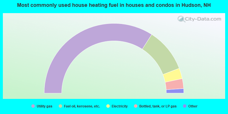
- 68.2%Utility gas
- 20.2%Fuel oil, kerosene, etc.
- 4.9%Electricity
- 4.6%Bottled, tank, or LP gas
- 1.6%Wood
- 0.5%Other fuel
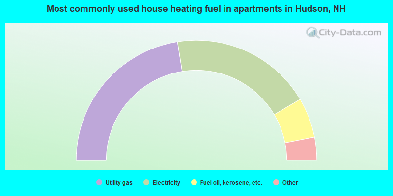
- 45.1%Utility gas
- 38.2%Electricity
- 10.8%Fuel oil, kerosene, etc.
- 3.7%Bottled, tank, or LP gas
- 2.1%No fuel used
Hudson compared to New Hampshire state average:
- Unemployed percentage significantly below state average.
- Black race population percentage significantly above state average.
- Hispanic race population percentage significantly below state average.
- Median age below state average.
- Length of stay since moving in above state average.

|
|
Total of 532 patent applications in 2008-2024.