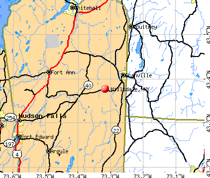
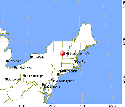
Hillsdale, New York
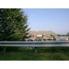
Submit your own pictures of this town and show them to the world
- OSM Map
- General Map
- Google Map
- MSN Map
Population change since 2000: +10.5%
 |
| Males: 998 | |
| Females: 929 |
| Median resident age: | 49.4 years |
| New York median age: | 40.7 years |
Zip codes: 12529.
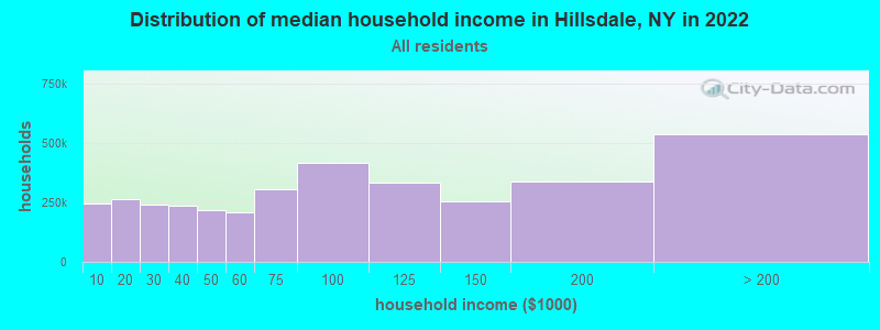
| Hillsdale: | $76,551 |
| NY: | $79,557 |
Estimated per capita income in 2022: $60,259 (it was $27,186 in 2000)
Hillsdale town income, earnings, and wages data
Estimated median house or condo value in 2022: $383,504 (it was $144,200 in 2000)
| Hillsdale: | $383,504 |
| NY: | $400,400 |
Mean prices in 2022: all housing units: $422,433; detached houses: $455,747; townhouses or other attached units: $597,881; in 2-unit structures: $391,116; in 3-to-4-unit structures: $525,972; in 5-or-more-unit structures: over $1,000,000; mobile homes: $85,716
Detailed information about poverty and poor residents in Hillsdale, NY


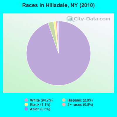
- 1,82494.7%White alone
- 542.8%Hispanic
- 211.1%Black alone
- 150.8%Two or more races
- 120.6%Asian alone
- 10.05%American Indian alone
Races in Hillsdale detailed stats: ancestries, foreign born residents, place of birth
According to our research of New York and other state lists, there were 2 registered sex offenders living in Hillsdale, New York as of May 10, 2024.
The ratio of all residents to sex offenders in Hillsdale is 964 to 1.
The ratio of registered sex offenders to all residents in this city is near the state average.
 Recent articles from our blog. Our writers, many of them Ph.D. graduates or candidates, create easy-to-read articles on a wide variety of topics.

 | Why don't we have a Hudson Valley forum? (66 replies) |
| Affluent Upstate NY... (139 replies) |
| Vaccinations for kids 5-11 (73 replies) |
| Bought a house years ago, kinda regretting it (40 replies) |
| Looking for Quaint Mountainy Town Semi-Close to NYC (47 replies) |
| Orange County, Tuxedo,Ny? (10 replies) |
Latest news from Hillsdale, NY collected exclusively by city-data.com from local newspapers, TV, and radio stations
Ancestries: German (19.4%), Irish (17.4%), Italian (15.3%), English (14.5%), Polish (7.9%), Dutch (6.0%).
Current Local Time: EST time zone
Land area: 47.6 square miles.
Population density: 40 people per square mile (very low).
116 residents are foreign born (4.8% Europe, 1.0% Latin America).
| This town: | 6.7% |
| New York: | 20.4% |
| Hillsdale town: | 1.9% ($2,672) |
| New York: | 1.9% ($2,847) |
Nearest city with pop. 50,000+: Albany, NY  (32.4 miles , pop. 95,658).
Nearest city with pop. 200,000+: Bronx, NY (97.0 miles , pop. 1,332,650).
Nearest cities:
), ), ), Latitude: 42.23 N, Longitude: 73.54 W
Area code: 518

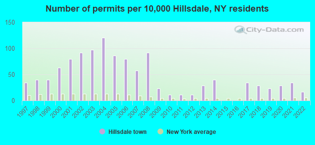
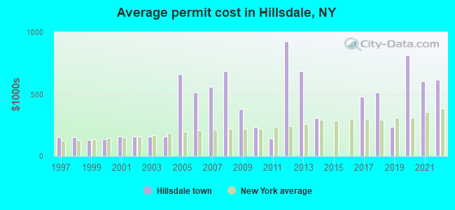
Single-family new house construction building permits:
- 2022: 3 buildings, average cost: $616,000
- 2021: 6 buildings, average cost: $606,700
- 2020: 5 buildings, average cost: $812,000
- 2019: 4 buildings, average cost: $239,300
- 2018: 5 buildings, average cost: $516,200
- 2017: 6 buildings, average cost: $482,500
- 2014: 7 buildings, average cost: $306,000
- 2013: 5 buildings, average cost: $684,600
- 2012: 2 buildings, average cost: $925,000
- 2011: 2 buildings, average cost: $142,500
- 2010: 2 buildings, average cost: $233,800
- 2009: 4 buildings, average cost: $375,800
- 2008: 16 buildings, average cost: $682,000
- 2007: 10 buildings, average cost: $561,100
- 2006: 14 buildings, average cost: $516,200
- 2005: 15 buildings, average cost: $658,600
- 2004: 21 buildings, average cost: $160,300
- 2003: 17 buildings, average cost: $160,300
- 2002: 16 buildings, average cost: $160,300
- 2001: 14 buildings, average cost: $160,300
- 2000: 11 buildings, average cost: $133,800
- 1999: 7 buildings, average cost: $130,600
- 1998: 7 buildings, average cost: $150,000
- 1997: 6 buildings, average cost: $150,000
| Here: | 3.2% |
| New York: | 4.4% |
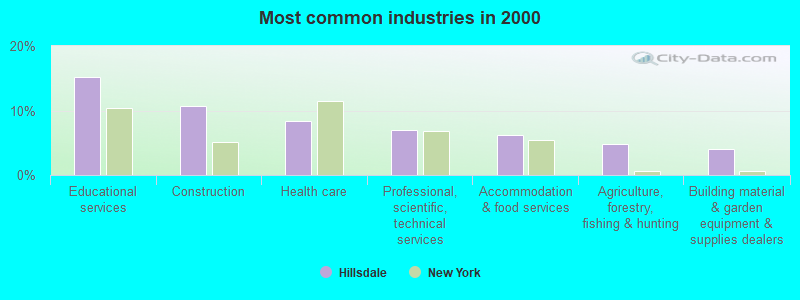
- Educational services (15.2%)
- Construction (10.6%)
- Health care (8.4%)
- Professional, scientific, technical services (6.9%)
- Accommodation & food services (6.2%)
- Agriculture, forestry, fishing & hunting (4.9%)
- Building material & garden equipment & supplies dealers (4.1%)
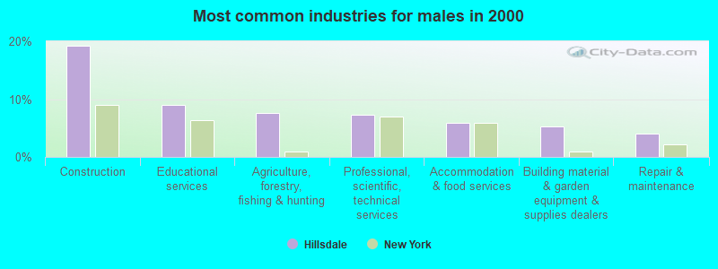
- Construction (19.1%)
- Educational services (8.9%)
- Agriculture, forestry, fishing & hunting (7.7%)
- Professional, scientific, technical services (7.2%)
- Accommodation & food services (6.0%)
- Building material & garden equipment & supplies dealers (5.3%)
- Repair & maintenance (4.0%)
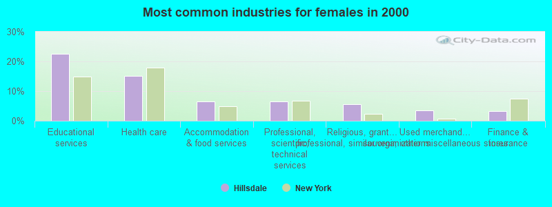
- Educational services (22.6%)
- Health care (15.2%)
- Accommodation & food services (6.6%)
- Professional, scientific, technical services (6.6%)
- Religious, grantmaking, civic, professional, similar organizations (5.6%)
- Used merchandise, gift, novelty, souvenir, other miscellaneous stores (3.6%)
- Finance & insurance (3.3%)
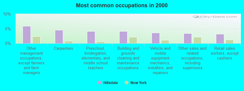
- Other management occupations, except farmers and farm managers (5.9%)
- Carpenters (4.5%)
- Preschool, kindergarten, elementary, and middle school teachers (4.2%)
- Building and grounds cleaning and maintenance occupations (4.2%)
- Vehicle and mobile equipment mechanics, installers, and repairers (3.6%)
- Other sales and related occupations, including supervisors (3.4%)
- Retail sales workers, except cashiers (3.2%)
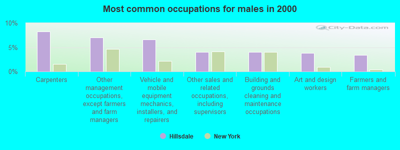
- Carpenters (8.3%)
- Other management occupations, except farmers and farm managers (7.0%)
- Vehicle and mobile equipment mechanics, installers, and repairers (6.6%)
- Other sales and related occupations, including supervisors (4.0%)
- Building and grounds cleaning and maintenance occupations (4.0%)
- Art and design workers (3.8%)
- Farmers and farm managers (3.4%)
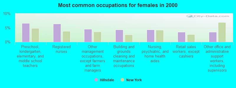
- Preschool, kindergarten, elementary, and middle school teachers (6.6%)
- Registered nurses (6.3%)
- Other management occupations, except farmers and farm managers (4.6%)
- Building and grounds cleaning and maintenance occupations (4.3%)
- Nursing, psychiatric, and home health aides (4.3%)
- Retail sales workers, except cashiers (3.6%)
- Other office and administrative support workers, including supervisors (3.6%)
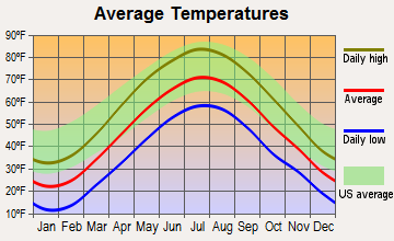
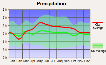
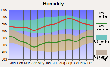
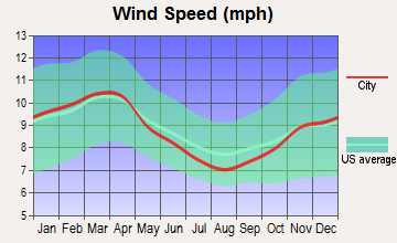
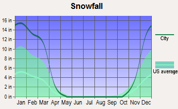
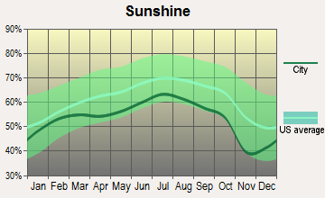
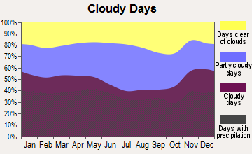
Average climate in Hillsdale, New York
Based on data reported by over 4,000 weather stations
(lower is better)
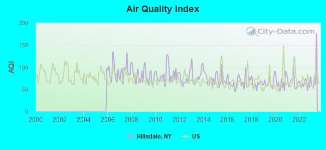
Air Quality Index (AQI) level in 2022 was 63.2. This is about average.
| City: | 63.2 |
| U.S.: | 72.6 |
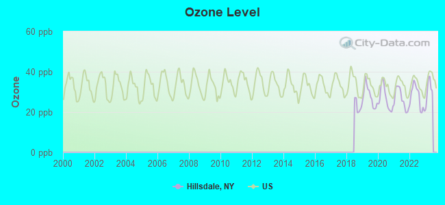
Ozone [ppb] level in 2022 was 27.5. This is better than average. Closest monitor was 21.8 miles away from the city center.
| City: | 27.5 |
| U.S.: | 33.3 |
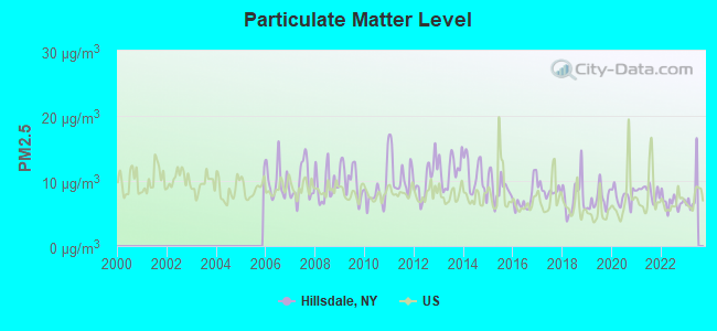
Particulate Matter (PM2.5) [µg/m3] level in 2022 was 6.76. This is about average. Closest monitor was 21.0 miles away from the city center.
| City: | 6.76 |
| U.S.: | 8.11 |
Tornado activity:
Hillsdale-area historical tornado activity is significantly above New York state average. It is 23% smaller than the overall U.S. average.
On 5/29/1995, a category F4 (max. wind speeds 207-260 mph) tornado 5.8 miles away from the Hillsdale town center killed 3 people and injured 24 people and caused between $5,000,000 and $50,000,000 in damages.
On 8/28/1973, a category F4 tornado 8.6 miles away from the town center killed 4 people and injured 36 people and caused between $5,000,000 and $50,000,000 in damages.
Earthquake activity:
Hillsdale-area historical earthquake activity is significantly above New York state average. It is 68% smaller than the overall U.S. average.On 10/7/1983 at 10:18:46, a magnitude 5.3 (5.1 MB, 5.3 LG, 5.1 ML, Class: Moderate, Intensity: VI - VII) earthquake occurred 126.1 miles away from Hillsdale center
On 4/20/2002 at 10:50:47, a magnitude 5.3 (5.3 ML, Depth: 3.0 mi) earthquake occurred 158.3 miles away from the city center
On 4/20/2002 at 10:50:47, a magnitude 5.2 (5.2 MB, 4.2 MS, 5.2 MW, 5.0 MW) earthquake occurred 156.6 miles away from Hillsdale center
On 1/19/1982 at 00:14:42, a magnitude 4.7 (4.5 MB, 4.7 MD, 4.5 LG, Class: Light, Intensity: IV - V) earthquake occurred 131.9 miles away from Hillsdale center
On 10/16/2012 at 23:12:25, a magnitude 4.7 (4.7 ML, Depth: 10.0 mi) earthquake occurred 174.0 miles away from the city center
On 8/23/2011 at 17:51:04, a magnitude 5.8 (5.8 MW, Depth: 3.7 mi) earthquake occurred 378.6 miles away from Hillsdale center
Magnitude types: regional Lg-wave magnitude (LG), body-wave magnitude (MB), duration magnitude (MD), local magnitude (ML), surface-wave magnitude (MS), moment magnitude (MW)
Natural disasters:
The number of natural disasters in Columbia County (22) is greater than the US average (15).Major Disasters (Presidential) Declared: 12
Emergencies Declared: 9
Causes of natural disasters: Storms: 7, Floods: 6, Hurricanes: 4, Winter Storms: 4, Snowstorms: 3, Blizzards: 2, Power Outage: 1, Tornado: 1, Other: 2 (Note: some incidents may be assigned to more than one category).

Hospitals and medical centers near Hillsdale:
- FAIRVIEW HOSPITAL Critical Access Hospitals (about 9 miles away; GREAT BARRINGTON, MA)
- KINDRED NRSING AND REHABILITATION-TIMBERLYN HEIGHTS (Nursing Home, about 9 miles away; GREAT BARRINGTON, MA)
- GREAT BARRINGTON REHABILITATION AND NURSING CENTER (Nursing Home, about 10 miles away; GREAT BARRINGTON, MA)
- FAIRVIEW HOSPITAL DIALYSIS CENTER (Dialysis Facility, about 10 miles away; GREAT BARRINGTON, MA)
- COLUMBIA COUNTY CHAPTER NYS ARC, INC (Hospital, about 12 miles away; HUDSON, NY)
- COLUMBIA MEMORIAL HOSPITAL Acute Care Hospitals (about 13 miles away; HUDSON, NY)
- EDEN PARK HEALTH CARE CENTRE INC HUDSON (Nursing Home, about 13 miles away; HUDSON, NY)
Amtrak station near Hillsdale:
Colleges/universities with over 2000 students nearest to Hillsdale:
- Bard College (about 24 miles; Annandale-On-Hudson, NY; Full-time enrollment: 3,137)
- The College of Saint Rose (about 33 miles; Albany, NY; FT enrollment: 4,085)
- Hudson Valley Community College (about 34 miles; Troy, NY; FT enrollment: 9,346)
- SUNY at Albany (about 36 miles; Albany, NY; FT enrollment: 15,490)
- Rensselaer Polytechnic Institute (about 36 miles; Troy, NY; FT enrollment: 6,940)
- The Sage Colleges (about 36 miles; Troy, NY; FT enrollment: 2,499)
- Siena College (about 36 miles; Loudonville, NY; FT enrollment: 3,153)
Library in Hillsdale:
Points of interest:
Notable locations in Hillsdale: Little Rainbow Chevre (A), White Oak Farms (B), Hawthorne Valley Farm (C). Display/hide their locations on the map
Church in Hillsdale: German Church (A). Display/hide its location on the map
Cemeteries: Harlemville Cemetery (1), Crum Church Cemetery (2), Hillsdale Cemetery (3), Collins Cemetery (4). Display/hide their locations on the map
Streams, rivers, and creeks: Westover Brook (A), Cranse Creek (B). Display/hide their locations on the map
Hotels: Celerohn Motel (9350 State Route 22) (1), Aubergine Fine Foods & Lodging (Intersection Of Rout) (2). Display/hide their approximate locations on the map
Birthplace of: Edward S. Hamlin - Politician, Ezra Dean - Politician, John Krum - Politician.
Drinking water stations with addresses in Hillsdale and their reported violations in the past:
HILLSDALE HOUSE (Population served: 65, Groundwater):Past monitoring violations:O'S HILLSDALE DINER (Address: 9276 ROUTE 22 , Population served: 60, Groundwater):
- Monitoring, Check/Repeat/Confirmation - Between JAN-2008 and DEC-2008, Contaminant: Nitrate. Follow-up actions: St Formal NOV issued (FEB-11-2009), St Compliance achieved (APR-29-2009)
- 7 routine major monitoring violations
- One regular monitoring violation
Past monitoring violations:MT. WASHINGTON HOUSE (Population served: 45, Groundwater):
- 7 routine major monitoring violations
- 2 regular monitoring violations
Past monitoring violations:INN AT GREEN RIVER (Address: 9 NOBLETOWN ROAD , Population served: 25, Groundwater):
- 7 routine major monitoring violations
- One regular monitoring violation
Past monitoring violations:HOLIDAY HOUSE MOTEL (Address: 2871 ROUTE 23 , Population served: 25, Groundwater):
- Monitoring, Check/Repeat/Confirmation - Between JAN-2008 and DEC-2008, Contaminant: Nitrate. Follow-up actions: St Formal NOV issued (FEB-11-2009), St Compliance achieved (JUL-28-2009)
- 11 routine major monitoring violations
- One regular monitoring violation
Past monitoring violations:HILLSDALE SUPERMARKET (Population served: 25, Groundwater):
- 5 routine major monitoring violations
- One regular monitoring violation
Past monitoring violations:CROSSROADS FOOD SHOP (Population served: 25, Groundwater):
- Monitoring, Check/Repeat/Confirmation - Between JAN-2007 and DEC-2007, Contaminant: Nitrate. Follow-up actions: St Formal NOV issued (FEB-04-2008), St Compliance achieved (MAR-24-2008)
- 7 routine major monitoring violations
- One regular monitoring violation
Past monitoring violations:
- 2 routine major monitoring violations
| This town: | 2.3 people |
| New York: | 2.6 people |
| This town: | 63.6% |
| Whole state: | 63.5% |
| This town: | 10.2% |
| Whole state: | 6.8% |
Likely homosexual households (counted as self-reported same-sex unmarried-partner households)
- Lesbian couples: 0.7% of all households
- Gay men: 2.7% of all households
| This town: | 8.3% |
| Whole state: | 14.6% |
| This town: | 3.5% |
| Whole state: | 7.4% |
Banks with branches in Hillsdale (2011 data):
- First Niagara Bank, National Association: Hillsdale Branch at 2628 Route 23, branch established on 1997/06/03. Info updated 2011/06/09: Bank assets: $32,750.6 mil, Deposits: $19,595.4 mil, headquarters in Buffalo, NY, positive income, Commercial Lending Specialization, 351 total offices, Holding Company: First Niagara Financial Group, Inc.
For population 15 years and over in Hillsdale:
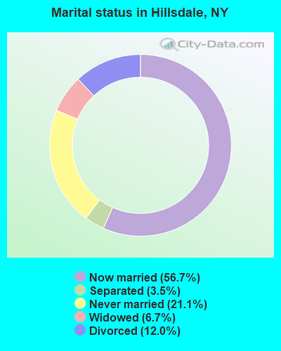
- Never married: 21.1%
- Now married: 56.7%
- Separated: 3.5%
- Widowed: 6.7%
- Divorced: 12.0%
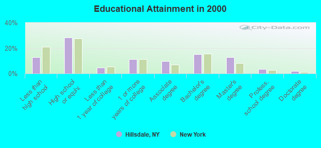
For population 25 years and over in Hillsdale:
- High school or higher: 87.1%
- Bachelor's degree or higher: 33.2%
- Graduate or professional degree: 18.1%
- Unemployed: 4.8%
- Mean travel time to work (commute): 26.9 minutes
| Here: | 11.8 |
| New York average: | 14.2 |
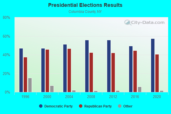
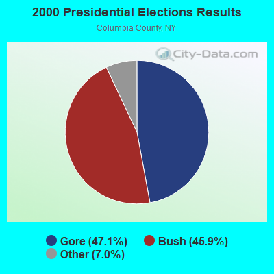
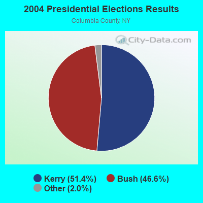
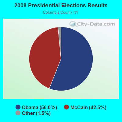

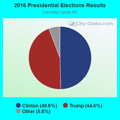
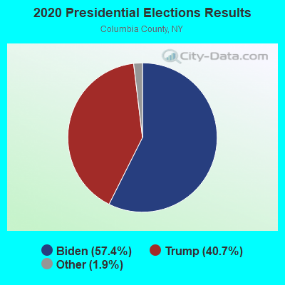
Graphs represent county-level data. Detailed 2008 Election Results
Religion statistics for Hillsdale, NY (based on Columbia County data)
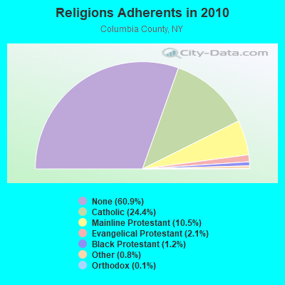
| Religion | Adherents | Congregations |
|---|---|---|
| Catholic | 15,375 | 11 |
| Mainline Protestant | 6,636 | 53 |
| Evangelical Protestant | 1,329 | 16 |
| Black Protestant | 776 | 3 |
| Other | 513 | 7 |
| Orthodox | 70 | 2 |
| None | 38,397 | - |
Food Environment Statistics:
| Here: | 3.54 / 10,000 pop. |
| State: | 4.13 / 10,000 pop. |
| Columbia County: | 0.80 / 10,000 pop. |
| State: | 0.92 / 10,000 pop. |
| This county: | 4.98 / 10,000 pop. |
| State: | 1.68 / 10,000 pop. |
| Columbia County: | 11.09 / 10,000 pop. |
| New York: | 8.82 / 10,000 pop. |
| Columbia County: | 8.6% |
| New York: | 8.2% |
| Here: | 27.0% |
| New York: | 23.8% |
| Here: | 17.1% |
| New York: | 15.6% |
Strongest AM radio stations in Hillsdale:
- WNNZ (640 AM; 50 kW; WESTFIELD, MA; Owner: CLEAR CHANNEL BROADCASTING LICENSES, INC.)
- WSBS (860 AM; 3 kW; GREAT BARRINGTON, MA; Owner: BERKSHIRE BROADCASTING CO., INC.)
- WGY (810 AM; 50 kW; SCHENECTADY, NY; Owner: CLEAR CHANNEL BROADCASTING LICENSES, INC.)
- WPTR (1540 AM; 50 kW; ALBANY, NY; Owner: KIMTRON, INC.)
- WTIC (1080 AM; 50 kW; HARTFORD, CT; Owner: INFINITY RADIO OPERATIONS INC.)
- WUHN (1110 AM; daytime; 5 kW; PITTSFIELD, MA; Owner: WEINER BROADCASTING, INC.)
- WROW (590 AM; 5 kW; ALBANY, NY; Owner: 6 JOHNSON ROAD LICENSES, INC.)
- WCRN (830 AM; 50 kW; WORCESTER, MA; Owner: CARTER BROADCASTING CORPORATION)
- WKZE (1020 AM; daytime; 2 kW; SHARON, CT; Owner: JOHNSON DEVELOPMENT, INC.)
- WFAN (660 AM; 50 kW; NEW YORK, NY; Owner: INFINITY BROADCASTING OPERATIONS, INC.)
- WMCA (570 AM; 50 kW; NEW YORK, NY; Owner: SALEM MEDIA OF NEW YORK, LLC)
- WABC (770 AM; 50 kW; NEW YORK, NY; Owner: WABC-AM RADIO, INC.)
- WOR (710 AM; 50 kW; NEW YORK, NY; Owner: BUCKLEY BROADCASTING CORPORATION)
Strongest FM radio stations in Hillsdale:
- WHVP (91.1 FM; HUDSON, NY; Owner: SOUND OF LIFE, INC.)
- WAMQ (105.1 FM; GREAT BARRINGTON, MA; Owner: WAMC)
- WAMC-FM (90.3 FM; ALBANY, NY; Owner: WAMC)
- WAMK (90.9 FM; KINGSTON, NY; Owner: W A M C)
- WFGB (89.7 FM; KINGSTON, NY; Owner: SOUND OF LIFE, INC.)
- WBEC-FM (105.5 FM; PITTSFIELD, MA; Owner: GREAT NORTHERN RADIO, LLC)
- WUPE (95.9 FM; PITTSFIELD, MA; Owner: WEINER BROADCASTING, INC.)
- WPDH (101.5 FM; POUGHKEEPSIE, NY; Owner: CUMULUS LICENSING CORP.)
- WCTW (98.5 FM; CATSKILL, NY; Owner: CLEAR CHANNEL BROADCASTING LICENSES, INC.)
- WKZE-FM (98.1 FM; SALISBURY, CT; Owner: JOHNSON DEVELOPMENT, INC.)
- WAJZ (96.3 FM; VOORHEESVILLE, NY; Owner: 6 JOHNSON ROAD LICENSES, INC.)
- WZEC (97.5 FM; HOOSICK FALLS, NY; Owner: GREAT NORTHERN RADIO, LLC)
- WEQX (102.7 FM; MANCHESTER, VT; Owner: NORTHSHIRE COMMUNICATIONS, INC.)
- WFNP (88.7 FM; ROSENDALE, NY; Owner: STATE UNIVERSITY OF NEW YORK)
- WRHV (88.7 FM; POUGHKEEPSIE, NY; Owner: WMHT EDUCATIONAL TELECOMMUNICATIONS)
- WZMR (104.9 FM; ALTAMONT, NY; Owner: 6 JOHNSON ROAD LICENSES, INC.)
- WJAN (95.1 FM; SUNDERLAND, VT; Owner: 6 JOHNSON ROAD LICENSES, INC.)
- WRIP (97.9 FM; WINDHAM, NY; Owner: RIP RADIO, LLC)
- WYJB (95.5 FM; ALBANY, NY; Owner: 6 JOHNSON ROAD LICENSES, INC.)
- WGNA-FM (107.7 FM; ALBANY, NY; Owner: REGENT LICENSEE OF MANSFIELD, INC.)
TV broadcast stations around Hillsdale:
- WTIC-TV (Channel 61; HARTFORD, CT; Owner: TRIBUNE TELEVISION COMPANY)
- Hillsdale, New York
- Fatal accident count10
- Vehicles involved in fatal accidents17
- Fatal accidents involving drunk persons:1
- Fatalities10
- Persons involved in fatal accidents25
- Pedestrians involved in fatal accidents0
- New York average
- Fatal accident count10289
- Vehicles involved in fatal accidents15335
- Fatal accidents involving drunk persons2393
- Fatalities11088
- Persons involved in fatal accidents25623
- Pedestrians involved in fatal accidents3375
- National Bridge Inventory (NBI) Statistics
- 19Number of bridges
- 85ft / 26.4mTotal length
- $15,398,000Total costs
- 20,323Total average daily traffic
- 2,295Total average daily truck traffic
- 23,217Total future (year 2035) average daily traffic
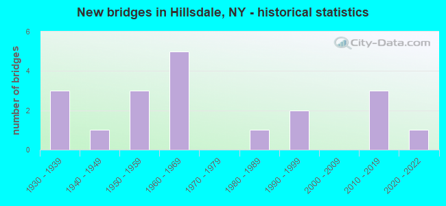
- New bridges - historical statistics
- 31930-1939
- 11940-1949
- 31950-1959
- 51960-1969
- 11980-1989
- 21990-1999
- 32010-2019
- 12020-2022
FCC Registered Cell Phone Towers:
1 (See the full list of FCC Registered Cell Phone Towers in Hillsdale)FCC Registered Antenna Towers:
22 (See the full list of FCC Registered Antenna Towers)FCC Registered Microwave Towers:
2- HILLSDALE, Overlook Dr (088132) (Lat: 42.242944 Lon: -73.486389), Type: Ltower, Structure height: 99.7 m, Overall height: 105.5 m, Call Sign: WQWE602,
Assigned Frequencies: 11485.0 MHz, 11565.0 MHz, 11485.0 MHz, 11565.0 MHz, 11485.0 MHz, 11565.0 MHz, 11485.0 MHz, 11565.0 MHz, 11485.0 MHz, 11565.0 MHz... (+8 more), Grant Date: 07/31/2015, Expiration Date: 07/31/2025, Certifier: Arnie M Cavallaro, Registrant: Business Radio Licensing, 30251 Golden Lantern, Suite E # 501, Laguna Niguel, CA 92677, Phone: (949) 348-8510, Fax: (949) 348-8514, Email:
- 3CBA229A, 78 Catamount Road (Lat: 42.165472 Lon: -73.485222), Type: Ltower, Structure height: 27.4 m, Overall height: 32 m, Call Sign: WQYZ741,
Assigned Frequencies: 6226.89 MHz, 6226.89 MHz, 6226.89 MHz, 6226.89 MHz, 6226.89 MHz, 6226.89 MHz, 6226.89 MHz, 6226.89 MHz, Grant Date: 03/14/2017, Expiration Date: 03/14/2027, Certifier: David Werblow, Registrant: T-Mobile Usa, Inc., 12920 Se 38th Street, Bellevue, WA 98006, Phone: (425) 383-8401, Fax: (425) 383-4040, Email:
FCC Registered Amateur Radio Licenses:
19 (See the full list of FCC Registered Amateur Radio Licenses in Hillsdale)FAA Registered Aircraft:
3- Aircraft: CIRRUS DESIGN CORP SR22 (Category: Land, Seats: 4, Weight: Up to 12,499 Pounds), Engine: CONT MOTOR IO-550-N (310 HP) (Reciprocating)
N-Number: 615EM, N615EM, N-615EM, Serial Number: 3682, Year manufactured: 2010, Airworthiness Date: 01/16/2018, Certificate Issue Date: 01/11/2018
Registrant (LLC): Ginther Associates LLC, 31 Mitchell St, Hillsdale, NY 12529 - Aircraft: CESSNA R182 (Category: Land, Seats: 4, Weight: Up to 12,499 Pounds, Speed: 111 mph), Engine: LYCOMING 0-540 SERIES (250 HP) (Reciprocating)
N-Number: 628RD, N628RD, N-628RD, Serial Number: R18201066, Year manufactured: 1979, Airworthiness Date: 04/28/1979, Certificate Issue Date: 08/18/2014
Registrant (Individual): Benjamin A Gebert, 569 W End Rd, Hillsdale, NY 12529 - Aircraft: LINDSTRAND BALLOONS 90A (Category: Land, Weight: Up to 12,499 Pounds), Engine: None
N-Number: 358LB, N358LB, N-358LB, Serial Number: 301, Year manufactured: 1995, Airworthiness Date: 09/22/1995, Certificate Issue Date: 10/22/2003
Registrant (Individual): Cia Ricco, Po Box 449, Hillsdale, NY 12529
Deregistered: Cancel Date: 01/18/2018
2002 - 2018 National Fire Incident Reporting System (NFIRS) incidents
- Fire incident types reported to NFIRS in Hillsdale, NY
- 7843.1%Structure Fires
- 6133.7%Outside Fires
- 2815.5%Mobile Property/Vehicle Fires
- 147.7%Other
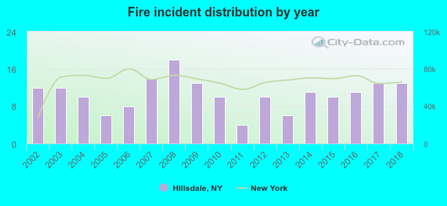 Based on the data from the years 2002 - 2018 the average number of fires per year is 11. The highest number of fires - 18 took place in 2008, and the least - 4 in 2011. The data has a growing trend.
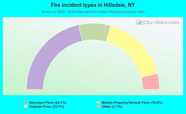 When looking into fire subcategories, the most incidents belonged to: Structure Fires (43.1%), and Outside Fires (33.7%).
- 66.9%Fuel oil, kerosene, etc.
- 11.7%Electricity
- 11.3%Wood
- 7.9%Bottled, tank, or LP gas
- 1.3%Other fuel
- 0.8%Coal or coke
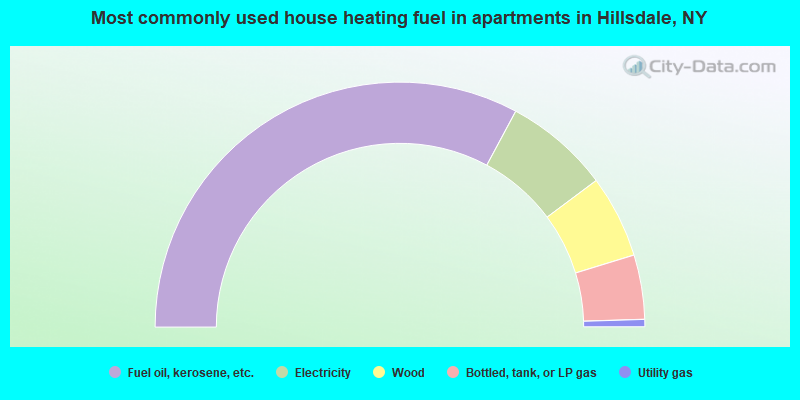
- 65.7%Fuel oil, kerosene, etc.
- 13.9%Electricity
- 10.9%Wood
- 8.5%Bottled, tank, or LP gas
- 1.0%Utility gas
Hillsdale compared to New York state average:
- Unemployed percentage significantly below state average.
- Black race population percentage significantly below state average.
- Hispanic race population percentage significantly below state average.
- Median age significantly above state average.
- Foreign-born population percentage significantly below state average.
- Renting percentage below state average.
- Length of stay since moving in significantly above state average.
- Number of rooms per house significantly below state average.
- House age significantly below state average.
- Number of college students below state average.

|
Total of 10 patent applications in 2008-2024.