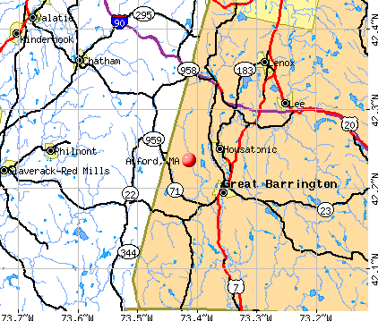
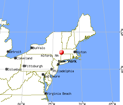
Alford, Massachusetts
Submit your own pictures of this town and show them to the world
- OSM Map
- General Map
- Google Map
- MSN Map
Population change since 2000: +23.8%
| Males: 228 | |
| Females: 266 |
| Median resident age: | 55.4 years |
| Massachusetts median age: | 39.2 years |
Zip codes: 01230.
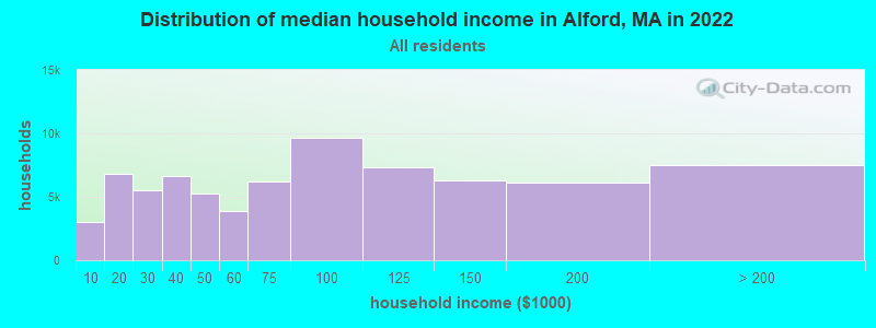
| Alford: | $94,284 |
| MA: | $94,488 |
Estimated per capita income in 2022: $90,644 (it was $40,412 in 2000)
Alford town income, earnings, and wages data
Estimated median house or condo value in 2022: $785,679 (it was $293,800 in 2000)
| Alford: | $785,679 |
| MA: | $534,700 |
Mean prices in 2022: all housing units: $357,971; detached houses: $376,086; townhouses or other attached units: $341,816; in 2-unit structures: $250,940; in 3-to-4-unit structures: $400,871; in 5-or-more-unit structures: $281,990; mobile homes: $80,872
Detailed information about poverty and poor residents in Alford, MA


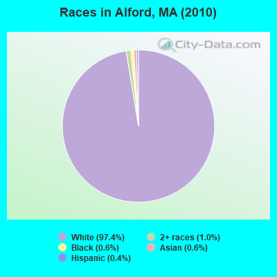
- 48197.4%White alone
- 51.0%Two or more races
- 30.6%Black alone
- 30.6%Asian alone
- 20.4%Hispanic
Races in Alford detailed stats: ancestries, foreign born residents, place of birth
 Recent articles from our blog. Our writers, many of them Ph.D. graduates or candidates, create easy-to-read articles on a wide variety of topics.


Latest news from Alford, MA collected exclusively by city-data.com from local newspapers, TV, and radio stations
Ancestries: Irish (22.3%), English (19.0%), German (14.5%), Italian (11.5%), United States (6.0%), French (5.8%).
Current Local Time: EST time zone
Incorporated in 1773
Elevation: 839 feet
Land area: 11.6 square miles.
Population density: 43 people per square mile (very low).
18 residents are foreign born (4.5% Europe).
| This town: | 4.5% |
| Massachusetts: | 12.2% |
| Alford town: | 0.6% ($1,670) |
| Massachusetts: | 1.3% ($2,336) |
Nearest city with pop. 50,000+: Albany, NY  (34.3 miles , pop. 95,658).
Nearest city with pop. 200,000+: Bronx, NY (99.4 miles , pop. 1,332,650).
Nearest cities:
), ), ), ), Latitude: 42.24 N, Longitude: 73.42 W
Area code commonly used in this area: 413

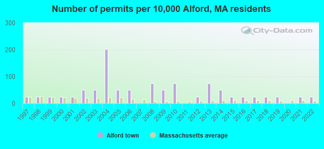
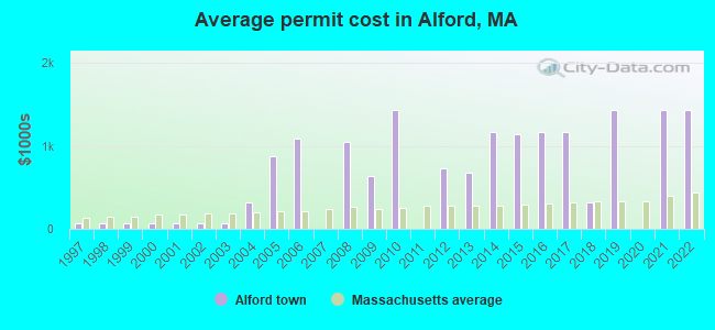
Single-family new house construction building permits:
- 2022: 1 building, cost: $1,435,000
- 2021: 1 building, cost: $1,435,000
- 2019: 1 building, cost: $1,435,000
- 2018: 1 building, cost: $320,000
- 2017: 1 building, cost: $1,167,200
- 2016: 1 building, cost: $1,167,200
- 2015: 1 building, cost: $1,146,000
- 2014: 2 buildings, average cost: $1,167,200
- 2013: 3 buildings, average cost: $680,700
- 2012: 1 building, cost: $737,000
- 2010: 3 buildings, average cost: $1,429,300
- 2009: 2 buildings, average cost: $637,000
- 2008: 3 buildings, average cost: $1,055,000
- 2006: 2 buildings, average cost: $1,091,100
- 2005: 2 buildings, average cost: $880,000
- 2004: 8 buildings, average cost: $315,800
- 2003: 2 buildings, average cost: $71,500
- 2002: 2 buildings, average cost: $71,500
- 2001: 1 building, cost: $71,500
- 2000: 1 building, cost: $71,500
- 1999: 1 building, cost: $71,500
- 1998: 1 building, cost: $71,500
- 1997: 1 building, cost: $71,500
| Here: | 2.2% |
| Massachusetts: | 3.5% |
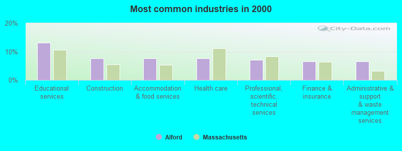
- Educational services (13.1%)
- Construction (7.5%)
- Accommodation & food services (7.5%)
- Health care (7.5%)
- Professional, scientific, technical services (7.0%)
- Finance & insurance (6.5%)
- Administrative & support & waste management services (6.5%)
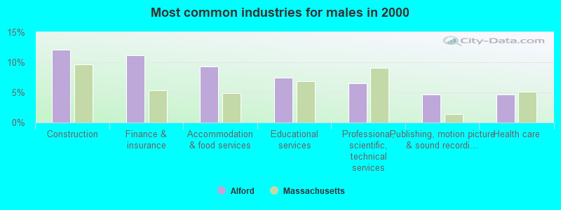
- Construction (12.1%)
- Finance & insurance (11.2%)
- Accommodation & food services (9.3%)
- Educational services (7.5%)
- Professional, scientific, technical services (6.5%)
- Publishing, motion picture & sound recording industries (4.7%)
- Health care (4.7%)
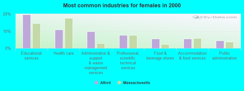
- Educational services (19.6%)
- Health care (10.9%)
- Administrative & support & waste management services (9.8%)
- Professional, scientific, technical services (7.6%)
- Food & beverage stores (5.4%)
- Accommodation & food services (5.4%)
- Public administration (4.3%)
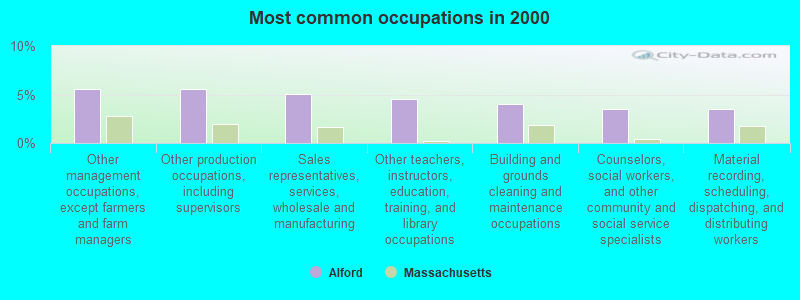
- Other management occupations, except farmers and farm managers (5.5%)
- Other production occupations, including supervisors (5.5%)
- Sales representatives, services, wholesale and manufacturing (5.0%)
- Other teachers, instructors, education, training, and library occupations (4.5%)
- Building and grounds cleaning and maintenance occupations (4.0%)
- Counselors, social workers, and other community and social service specialists (3.5%)
- Material recording, scheduling, dispatching, and distributing workers (3.5%)
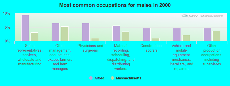
- Sales representatives, services, wholesale and manufacturing (9.3%)
- Other management occupations, except farmers and farm managers (6.5%)
- Physicians and surgeons (6.5%)
- Material recording, scheduling, dispatching, and distributing workers (5.6%)
- Construction laborers (4.7%)
- Vehicle and mobile equipment mechanics, installers, and repairers (4.7%)
- Other production occupations, including supervisors (4.7%)
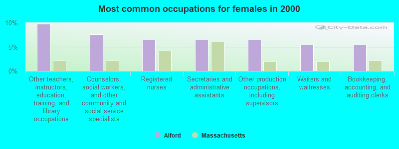
- Other teachers, instructors, education, training, and library occupations (9.8%)
- Counselors, social workers, and other community and social service specialists (7.6%)
- Registered nurses (6.5%)
- Secretaries and administrative assistants (6.5%)
- Other production occupations, including supervisors (6.5%)
- Waiters and waitresses (5.4%)
- Bookkeeping, accounting, and auditing clerks (5.4%)
Average climate in Alford, Massachusetts
Based on data reported by over 4,000 weather stations


(lower is better)
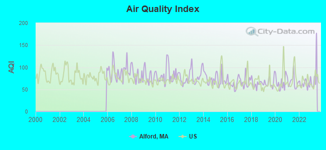
Air Quality Index (AQI) level in 2022 was 63.2. This is about average.
| City: | 63.2 |
| U.S.: | 72.6 |
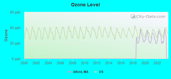
Ozone [ppb] level in 2022 was 27.5. This is better than average. Closest monitor was 17.1 miles away from the city center.
| City: | 27.5 |
| U.S.: | 33.3 |
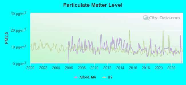
Particulate Matter (PM2.5) [µg/m3] level in 2022 was 6.76. This is about average. Closest monitor was 16.4 miles away from the city center.
| City: | 6.76 |
| U.S.: | 8.11 |
Tornado activity:
Alford-area historical tornado activity is slightly above Massachusetts state average. It is 20% smaller than the overall U.S. average.
On 8/28/1973, a category F4 (max. wind speeds 207-260 mph) tornado 2.7 miles away from the Alford town center killed 4 people and injured 36 people and caused between $5,000,000 and $50,000,000 in damages.
On 5/29/1995, a category F4 tornado 3.0 miles away from the town center killed 3 people and injured 24 people and caused between $5,000,000 and $50,000,000 in damages.
Earthquake activity:
Alford-area historical earthquake activity is significantly above Massachusetts state average. It is 68% smaller than the overall U.S. average.On 10/7/1983 at 10:18:46, a magnitude 5.3 (5.1 MB, 5.3 LG, 5.1 ML, Class: Moderate, Intensity: VI - VII) earthquake occurred 127.2 miles away from the city center
On 4/20/2002 at 10:50:47, a magnitude 5.3 (5.3 ML, Depth: 3.0 mi) earthquake occurred 157.6 miles away from Alford center
On 4/20/2002 at 10:50:47, a magnitude 5.2 (5.2 MB, 4.2 MS, 5.2 MW, 5.0 MW) earthquake occurred 156.0 miles away from the city center
On 1/19/1982 at 00:14:42, a magnitude 4.7 (4.5 MB, 4.7 MD, 4.5 LG, Class: Light, Intensity: IV - V) earthquake occurred 126.6 miles away from the city center
On 10/16/2012 at 23:12:25, a magnitude 4.7 (4.7 ML, Depth: 10.0 mi) earthquake occurred 168.3 miles away from Alford center
On 8/23/2011 at 17:51:04, a magnitude 5.8 (5.8 MW, Depth: 3.7 mi) earthquake occurred 383.3 miles away from the city center
Magnitude types: regional Lg-wave magnitude (LG), body-wave magnitude (MB), duration magnitude (MD), local magnitude (ML), surface-wave magnitude (MS), moment magnitude (MW)
Natural disasters:
The number of natural disasters in Berkshire County (21) is greater than the US average (15).Major Disasters (Presidential) Declared: 10
Emergencies Declared: 10
Causes of natural disasters: Floods: 5, Snowstorms: 5, Storms: 5, Hurricanes: 4, Winter Storms: 4, Blizzards: 2, Snows: 2, Snowfall: 1, Tropical Storm: 1, Wind: 1, Other: 1 (Note: some incidents may be assigned to more than one category).
Hospitals and medical centers near Alford:
- FAIRVIEW HOSPITAL Critical Access Hospitals (about 5 miles away; GREAT BARRINGTON, MA)
- FAIRVIEW HOSPITAL DIALYSIS CENTER (Dialysis Facility, about 5 miles away; GREAT BARRINGTON, MA)
- GREAT BARRINGTON REHABILITATION AND NURSING CENTER (Nursing Home, about 5 miles away; GREAT BARRINGTON, MA)
- KINDRED NRSING AND REHABILITATION-TIMBERLYN HEIGHTS (Nursing Home, about 5 miles away; GREAT BARRINGTON, MA)
- LEE REGIONAL VNA INC. (Home Health Center, about 10 miles away; LEE, MA)
- KINDRED NURSING AND REHABILITATION-LAUREL LAKE (Nursing Home, about 10 miles away; LEE, MA)
- EDGECOMBE NURSING HOME (Nursing Home, about 11 miles away; LENOX, MA)
Amtrak stations near Alford:
- 17 miles: PITTSFIELD (DEPOT ST. BTW NORTH & CENTER STS.) . Services: enclosed waiting area, public payphones, free short-term parking, free long-term parking, taxi stand, intercity bus service, public transit connection.
- 20 miles: HUDSON (69 S. FRONT ST.) . Services: ticket office, partially wheelchair accessible, enclosed waiting area, public restrooms, public payphones, snack bar, free short-term parking, free long-term parking, call for car rental service, call for taxi service, public transit connection.
Colleges/universities with over 2000 students nearest to Alford:
- Bard College (about 30 miles; Annandale-On-Hudson, NY; Full-time enrollment: 3,137)
- Westfield State University (about 33 miles; Westfield, MA; FT enrollment: 5,548)
- Williams College (about 35 miles; Williamstown, MA; FT enrollment: 2,141)
- Hudson Valley Community College (about 35 miles; Troy, NY; FT enrollment: 9,346)
- The College of Saint Rose (about 35 miles; Albany, NY; FT enrollment: 4,085)
- Rensselaer Polytechnic Institute (about 37 miles; Troy, NY; FT enrollment: 6,940)
- The Sage Colleges (about 37 miles; Troy, NY; FT enrollment: 2,499)
Private high school in Alford:
Public elementary/middle school in Alford:
- BRADFORD ELEMENTARY (Students: 622, Location: 118 MONTVALE STREET, Grades: KG-5)
Private elementary/middle school in Alford:
Points of interest:
Notable locations in Alford: Alford Fire Department (A), Alford Free Public Library (B), Alford Town Hall (C). Display/hide their locations on the map
Streams, rivers, and creeks: Tom Ball Brook (A), Alford Brook (B). Display/hide their locations on the map
| This town: | 2.2 people |
| Massachusetts: | 2.5 people |
| This town: | 65.5% |
| Whole state: | 63.0% |
| This town: | 7.2% |
| Whole state: | 7.0% |
No gay or lesbian households reported
| This town: | 4.1% |
| Whole state: | 9.3% |
| This town: | 2.8% |
| Whole state: | 4.4% |
For population 15 years and over in Alford:
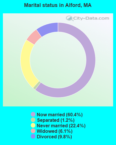
- Never married: 22.4%
- Now married: 60.4%
- Separated: 1.2%
- Widowed: 6.1%
- Divorced: 9.8%
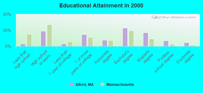
For population 25 years and over in Alford:
- High school or higher: 96.7%
- Bachelor's degree or higher: 51.5%
- Graduate or professional degree: 28.7%
- Unemployed: 2.9%
- Mean travel time to work (commute): 21.8 minutes
| Here: | 10.4 |
| Massachusetts average: | 13.1 |


Graphs represent county-level data. Detailed 2008 Election Results
Religion statistics for Alford, MA (based on Berkshire County data)


| Religion | Adherents | Congregations |
|---|---|---|
| Catholic | 50,187 | 32 |
| Mainline Protestant | 9,895 | 63 |
| Other | 3,647 | 20 |
| Evangelical Protestant | 2,817 | 28 |
| Black Protestant | 233 | 2 |
| Orthodox | 225 | 2 |
| None | 64,215 | - |
Food Environment Statistics:
| Berkshire County: | 2.54 / 10,000 pop. |
| Massachusetts: | 1.98 / 10,000 pop. |
| Berkshire County: | 1.61 / 10,000 pop. |
| Massachusetts: | 2.22 / 10,000 pop. |
| Berkshire County: | 4.08 / 10,000 pop. |
| State: | 1.77 / 10,000 pop. |
| Here: | 15.00 / 10,000 pop. |
| State: | 8.76 / 10,000 pop. |
| This county: | 8.0% |
| Massachusetts: | 8.1% |
| Berkshire County: | 22.8% |
| Massachusetts: | 22.5% |
| This county: | 9.9% |
| State: | 16.5% |
Strongest AM radio stations in Alford:
- WSBS (860 AM; 3 kW; GREAT BARRINGTON, MA; Owner: BERKSHIRE BROADCASTING CO., INC.)
- WNNZ (640 AM; 50 kW; WESTFIELD, MA; Owner: CLEAR CHANNEL BROADCASTING LICENSES, INC.)
- WGY (810 AM; 50 kW; SCHENECTADY, NY; Owner: CLEAR CHANNEL BROADCASTING LICENSES, INC.)
- WTIC (1080 AM; 50 kW; HARTFORD, CT; Owner: INFINITY RADIO OPERATIONS INC.)
- WUHN (1110 AM; daytime; 5 kW; PITTSFIELD, MA; Owner: WEINER BROADCASTING, INC.)
- WPTR (1540 AM; 50 kW; ALBANY, NY; Owner: KIMTRON, INC.)
- WCRN (830 AM; 50 kW; WORCESTER, MA; Owner: CARTER BROADCASTING CORPORATION)
- WROW (590 AM; 5 kW; ALBANY, NY; Owner: 6 JOHNSON ROAD LICENSES, INC.)
- WFAN (660 AM; 50 kW; NEW YORK, NY; Owner: INFINITY BROADCASTING OPERATIONS, INC.)
- WMCA (570 AM; 50 kW; NEW YORK, NY; Owner: SALEM MEDIA OF NEW YORK, LLC)
- WVNE (760 AM; daytime; 25 kW; LEICESTER, MA; Owner: BLOUNT MASSCOM, INC.)
- WKZE (1020 AM; daytime; 2 kW; SHARON, CT; Owner: JOHNSON DEVELOPMENT, INC.)
- WABC (770 AM; 50 kW; NEW YORK, NY; Owner: WABC-AM RADIO, INC.)
Strongest FM radio stations in Alford:
- WHVP (91.1 FM; HUDSON, NY; Owner: SOUND OF LIFE, INC.)
- WAMQ (105.1 FM; GREAT BARRINGTON, MA; Owner: WAMC)
- WAMC-FM (90.3 FM; ALBANY, NY; Owner: WAMC)
- WBEC-FM (105.5 FM; PITTSFIELD, MA; Owner: GREAT NORTHERN RADIO, LLC)
- WUPE (95.9 FM; PITTSFIELD, MA; Owner: WEINER BROADCASTING, INC.)
- WAMK (90.9 FM; KINGSTON, NY; Owner: W A M C)
- WFGB (89.7 FM; KINGSTON, NY; Owner: SOUND OF LIFE, INC.)
- WZEC (97.5 FM; HOOSICK FALLS, NY; Owner: GREAT NORTHERN RADIO, LLC)
- WEQX (102.7 FM; MANCHESTER, VT; Owner: NORTHSHIRE COMMUNICATIONS, INC.)
- WPDH (101.5 FM; POUGHKEEPSIE, NY; Owner: CUMULUS LICENSING CORP.)
- WJAN (95.1 FM; SUNDERLAND, VT; Owner: 6 JOHNSON ROAD LICENSES, INC.)
- WKZE-FM (98.1 FM; SALISBURY, CT; Owner: JOHNSON DEVELOPMENT, INC.)
- WAJZ (96.3 FM; VOORHEESVILLE, NY; Owner: 6 JOHNSON ROAD LICENSES, INC.)
- WZMR (104.9 FM; ALTAMONT, NY; Owner: 6 JOHNSON ROAD LICENSES, INC.)
- WFNP (88.7 FM; ROSENDALE, NY; Owner: STATE UNIVERSITY OF NEW YORK)
- WRHV (88.7 FM; POUGHKEEPSIE, NY; Owner: WMHT EDUCATIONAL TELECOMMUNICATIONS)
- WHYN-FM (93.1 FM; SPRINGFIELD, MA; Owner: CLEAR CHANNEL BROADCASTING LICENSES, INC.)
- WYJB (95.5 FM; ALBANY, NY; Owner: 6 JOHNSON ROAD LICENSES, INC.)
- WRCH (100.5 FM; NEW BRITAIN, CT; Owner: INFINITY RADIO OPERATIONS INC.)
- WGNA-FM (107.7 FM; ALBANY, NY; Owner: REGENT LICENSEE OF MANSFIELD, INC.)
TV broadcast stations around Alford:
- WTIC-TV (Channel 61; HARTFORD, CT; Owner: TRIBUNE TELEVISION COMPANY)
- W11BJ (Channel 11; HARTFORD, CT; Owner: COMMUNICATIONS SITE MANAGEMENT LLC)
- WTXX (Channel 20; WATERBURY, CT; Owner: WTXX INC.)
- WUVN (Channel 18; HARTFORD, CT; Owner: ENTRAVISION HOLDINGS, LLC)
Alford fatal accident list:
Nov 6, 1989 11:30 AM, Route 71, Vehicles: 2, Persons: 3, Fatalities: 1, Drunk persons involved: 1
- National Bridge Inventory (NBI) Statistics
- 4Number of bridges
- 23ft / 7.1mTotal length
- $5,760,000Total costs
- 3,644Total average daily traffic
- 135Total average daily truck traffic
- 2,527Total future (year 2031) average daily traffic
FCC Registered Broadcast Land Mobile Towers:
2- Lat: 42.230111 Lon: -73.440361, Call Sign: WQAP216,
Assigned Frequencies: 151.925 MHz, Grant Date: 07/13/2004, Expiration Date: 07/13/2014, Cancellation Date: 09/13/2014, Certifier: Riachard A Bailly, Registrant: The Alarm Room Inc, 44 Suffolk Drive, East Hartford, CT 06118-2697, Phone: (860) 568-6254, Fax: (860) 568-6524
- Lat: 42.226306 Lon: -73.422917, Call Sign: WQUY986,
Assigned Frequencies: 159.450 MHz, Grant Date: 11/21/2014, Expiration Date: 11/21/2024, Certifier: Philip Bailly, Registrant: Washington Radio Reports, Gettysburg, PA 17325, Phone: (717) 334-0668, Fax: (717) 334-6440, Email:
FCC Registered Amateur Radio Licenses:
2- Call Sign: KA2AVR, Licensee ID: L01000394, Grant Date: 05/07/2015, Expiration Date: 07/11/2025, Registrant: Paul Tepper, 131 West Rd, Alford, MA 01266
- Call Sign: KB1BS, Previous Call Sign: KE3NB, Licensee ID: L00354599, Grant Date: 03/05/2021, Expiration Date: 05/26/2031, Certifier: Bruce B Schreiber, Registrant: Bruce B Schreiber, 281 West Road, Alford, MA 01266
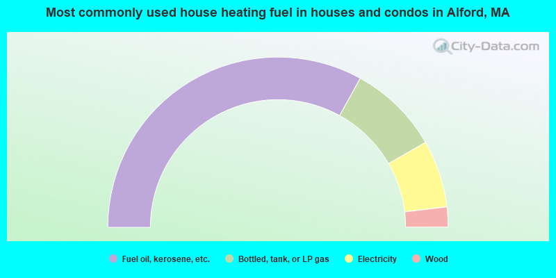
- 66.0%Fuel oil, kerosene, etc.
- 17.3%Bottled, tank, or LP gas
- 12.8%Electricity
- 3.8%Wood
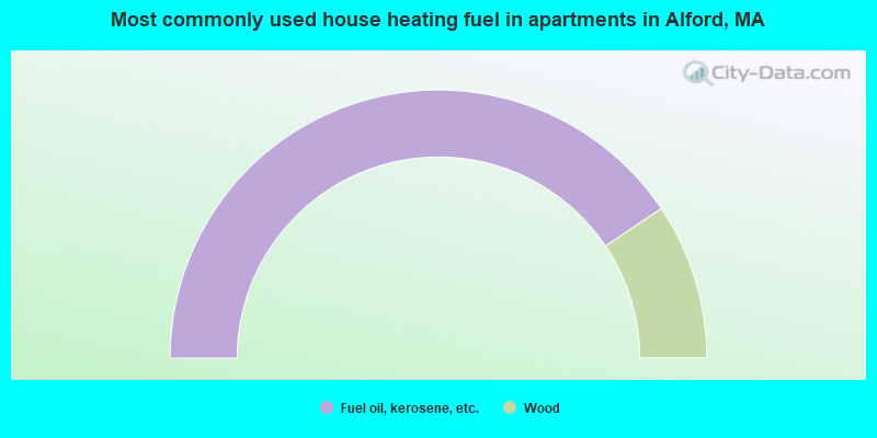
- 81.2%Fuel oil, kerosene, etc.
- 18.8%Wood
Alford compared to Massachusetts state average:
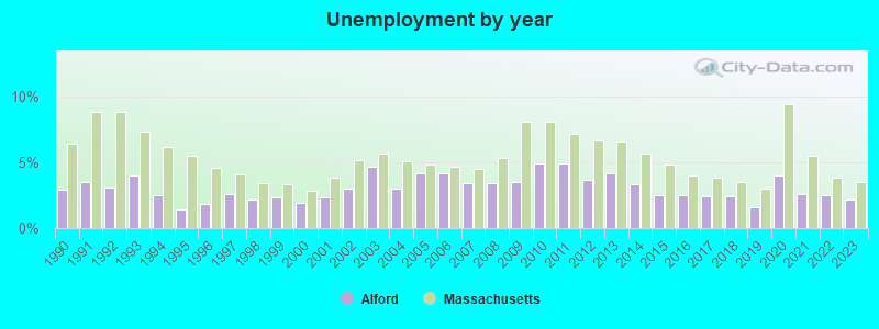
- Unemployed percentage significantly below state average.
- Black race population percentage significantly below state average.
- Hispanic race population percentage significantly below state average.
- Median age significantly above state average.
- Foreign-born population percentage significantly below state average.
- Renting percentage significantly below state average.
- Length of stay since moving in significantly above state average.
- Number of rooms per house significantly below state average.
- House age significantly below state average.
- Number of college students below state average.
- Percentage of population with a bachelor's degree or higher above state average.

|
Total of 2 patent applications in 2008-2024.