Hillsdale, Illinois
Submit your own pictures of this village and show them to the world
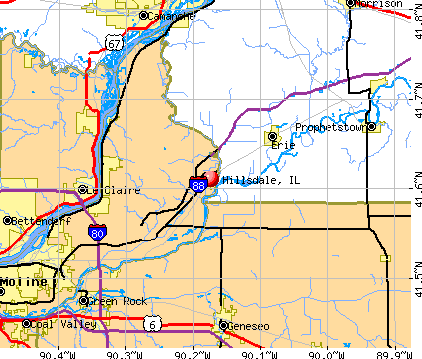
- OSM Map
- General Map
- Google Map
- MSN Map
Population change since 2000: -30.6%
 |
| Males: 205 | |
| Females: 203 |
| Median resident age: | 35.5 years |
| Illinois median age: | 39.1 years |
Zip codes: 61257.
| Hillsdale: | $87,831 |
| IL: | $76,708 |
Estimated per capita income in 2022: $27,621 (it was $21,772 in 2000)
Hillsdale village income, earnings, and wages data
Estimated median house or condo value in 2022: $90,089 (it was $63,800 in 2000)
| Hillsdale: | $90,089 |
| IL: | $251,600 |
Mean prices in 2022: all housing units: $193,586; detached houses: $199,126; townhouses or other attached units: $224,521; in 2-unit structures: $97,393; in 3-to-4-unit structures: $299,927; in 5-or-more-unit structures: $112,284; mobile homes: $18,969
Median gross rent in 2022: $701.
Detailed information about poverty and poor residents in Hillsdale, IL
Compare current foreclosures near Hillsdale, IL:
| Photo | Address | Area | Beds / Baths | Price | Details |
|---|---|---|---|---|---|

|
#1
94th Ave N
Hillsdale, IL 61257
|
- sq. feet
|
- baths - beds |
show details | |

|
#2
256th Street N
Hillsdale, IL 61257
|
- sq. feet
|
- baths - beds |
show details | |

|
#3
1st Ave N
Hillsdale, IL 61257
|
- sq. feet
|
- baths - beds |
show details | |

|
#4
9th Ave S
Clinton, IA 52732
|
1,572 sq. feet
|
1 baths 4 beds |
$109,900
|
show details |

|
#5
4th Ave
East Moline, IL 61244
|
805 sq. feet
|
1 baths 2 beds |
$110,000
|
show details |

|
#6
S Main St
Albany, IL 61230
|
1,564 sq. feet
|
1 baths 3 beds |
$133,000
|
show details |

|
#7
4th St E
Lyndon, IL 61261
|
1,008 sq. feet
|
- baths - beds |
$15,000
|
show details |

|
#8
Dodge St
Le Claire, IA 52753
|
1,224 sq. feet
|
1 baths 3 beds |
show details | |

|
#9
7th St
East Moline, IL 61244
|
- sq. feet
|
1 baths 4 beds |
show details | |

|
#10
14th Ave
Silvis, IL 61282
|
858 sq. feet
|
1 baths 3 beds |
show details |
| Photo | Address | Area | Beds / Baths | Price | Details |
|---|---|---|---|---|---|

|
#11
Main St
Hooppole, IL 61258
|
1,640 sq. feet
|
2 baths 3 beds |
show details | |

|
#12
N College Ave
Geneseo, IL 61254
|
1,584 sq. feet
|
2 baths 3 beds |
show details | |

|
#13
Pershing Blvd
Clinton, IA 52732
|
- sq. feet
|
- baths - beds |
$7,500
|
show details |

|
#14
3rd St S
Cordova, IL 61242
|
1,576 sq. feet
|
2 baths 5 beds |
show details | |

|
#15
Dodge St
Le Claire, IA 52753
|
1,224 sq. feet
|
1 baths 3 beds |
show details | |

|
#16
Cypress Dr
Colona, IL 61241
|
1,396 sq. feet
|
1 baths 3 beds |
show details | |

|
#17
Pleasant Dr
Bettendorf, IA 52722
|
1,400 sq. feet
|
1 baths 3 beds |
show details | |

|
#18
2nd Ave N
Clinton, IA 52732
|
1 sq. feet
|
1 baths 3 beds |
show details | |

|
#19
17th Ave
Bettendorf, IA 52722
|
3,065 sq. feet
|
1 baths 4 beds |
show details | |

|
#20
9th Ave S
Clinton, IA 52732
|
- sq. feet
|
- baths - beds |
$16,900
|
show details |
| Photo | Address | Area | Beds / Baths | Price | Details |
|---|---|---|---|---|---|

|
#21
S 18th St
Clinton, IA 52732
|
- sq. feet
|
1 baths 2 beds |
show details | |

|
#22
Holland St
Le Claire, IA 52753
|
1,418 sq. feet
|
1 baths 3 beds |
show details | |

|
#23
56th Avenue Ct E
Bettendorf, IA 52722
|
3,026 sq. feet
|
1 baths 5 beds |
show details | |

|
#24
Jones St
Le Claire, IA 52753
|
1,164 sq. feet
|
1 baths 4 beds |
show details | |

|
#25
Talbot Rd
Geneseo, IL 61254
|
1,520 sq. feet
|
1 baths 2 beds |
show details | |

|
#26
Pigeon Creek Trl
Bettendorf, IA 52722
|
4,275 sq. feet
|
1 baths 5 beds |
show details | |

|
#27
S 11th St
Le Claire, IA 52753
|
1,028 sq. feet
|
1 baths 4 beds |
show details | |

|
#28
Goldfinch Ct
Geneseo, IL 61254
|
3,240 sq. feet
|
1 baths 5 beds |
show details | |

|
#29
Meadow Ln
Colona, IL 61241
|
1,392 sq. feet
|
1 baths 3 beds |
show details | |

|
#30
S Center St
Geneseo, IL 61254
|
1,159 sq. feet
|
1 baths 4 beds |
show details |
| Photo | Address | Area | Beds / Baths | Price | Details |
|---|---|---|---|---|---|

|
#31
4th St
Carbon Cliff, IL 61239
|
912 sq. feet
|
- baths - beds |
show details | |

|
#32
4th St
East Moline, IL 61244
|
1,944 sq. feet
|
- baths - beds |
show details | |

|
#33
80th Ave N
Port Byron, IL 61275
|
- sq. feet
|
- baths - beds |
show details | |

|
#34
E Commercial St
Lyndon, IL 61261
|
- sq. feet
|
- baths - beds |
show details | |

|
#35
3rd Ave S
Albany, IL 61230
|
- sq. feet
|
- baths - beds |
show details | |

|
#36
11th St, # 10
Silvis, IL 61282
|
- sq. feet
|
- baths - beds |
show details | |

|
#37
10th Street Pl
East Moline, IL 61244
|
- sq. feet
|
- baths - beds |
show details | |

|
#38
10th St
East Moline, IL 61244
|
- sq. feet
|
- baths - beds |
show details | |

|
#39
Lauren Ln
Bettendorf, IA 52722
|
- sq. feet
|
- baths - beds |
show details | |

|
#40
River Rd
East Moline, IL 61244
|
- sq. feet
|
- baths - beds |
show details |
| Photo | Address | Area | Beds / Baths | Price | Details |
|---|---|---|---|---|---|

|
#41
12th St
East Moline, IL 61244
|
- sq. feet
|
- baths - beds |
show details | |

|
#42
Taylor Dr Apt 907
Port Byron, IL 61275
|
- sq. feet
|
- baths - beds |
show details | |

|
#43
2nd St
Camanche, IA 52730
|
- sq. feet
|
- baths - beds |
show details | |

|
#44
Lincoln Way # 1
Clinton, IA 52732
|
- sq. feet
|
- baths - beds |
show details | |

|
#45
E Orange St
Geneseo, IL 61254
|
- sq. feet
|
- baths - beds |
show details | |

|
#46
9th Ave
Silvis, IL 61282
|
- sq. feet
|
- baths - beds |
show details | |

|
#47
S 6th St
Clinton, IA 52732
|
- sq. feet
|
- baths - beds |
show details | |

|
#48
12th St
East Moline, IL 61244
|
- sq. feet
|
- baths - beds |
show details | |

|
#49
36 1/2 Ave
East Moline, IL 61244
|
- sq. feet
|
- baths - beds |
show details | |

|
Check over 1 million property listings on Foreclosure.com!
|
browse all offers | |||


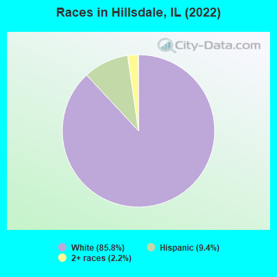
- 46685.8%White alone
- 519.4%Hispanic
- 122.2%Two or more races
Races in Hillsdale detailed stats: ancestries, foreign born residents, place of birth
According to our research of Illinois and other state lists, there were 6 registered sex offenders living in Hillsdale, Illinois as of May 13, 2024.
The ratio of all residents to sex offenders in Hillsdale is 92 to 1.
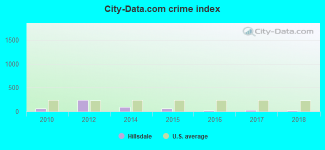
Type |
2010 |
2012 |
2014 |
2015 |
2016 |
2017 |
2018 |
|---|---|---|---|---|---|---|---|
| Murders (per 100,000) | 0 (0.0) | 0 (0.0) | 0 (0.0) | 0 (0.0) | 0 (0.0) | 0 (0.0) | 0 (0.0) |
| Rapes (per 100,000) | 0 (0.0) | 1 (191.2) | 0 (0.0) | 0 (0.0) | 0 (0.0) | 0 (0.0) | 0 (0.0) |
| Robberies (per 100,000) | 0 (0.0) | 0 (0.0) | 0 (0.0) | 0 (0.0) | 0 (0.0) | 0 (0.0) | 0 (0.0) |
| Assaults (per 100,000) | 0 (0.0) | 0 (0.0) | 0 (0.0) | 0 (0.0) | 0 (0.0) | 0 (0.0) | 0 (0.0) |
| Burglaries (per 100,000) | 2 (382.4) | 4 (764.8) | 1 (194.2) | 1 (196.1) | 0 (0.0) | 2 (397.6) | 0 (0.0) |
| Thefts (per 100,000) | 5 (956.0) | 4 (764.8) | 10 (1,942) | 6 (1,176) | 2 (392.9) | 0 (0.0) | 0 (0.0) |
| Auto thefts (per 100,000) | 0 (0.0) | 0 (0.0) | 0 (0.0) | 0 (0.0) | 0 (0.0) | 0 (0.0) | 1 (196.1) |
| Arson (per 100,000) | 0 (0.0) | 0 (0.0) | 0 (0.0) | 0 (0.0) | 0 (0.0) | 0 (0.0) | 0 (0.0) |
| City-Data.com crime index | 65.0 | 237.1 | 91.3 | 60.8 | 15.7 | 27.8 | 15.7 |
The City-Data.com crime index weighs serious crimes and violent crimes more heavily. Higher means more crime, U.S. average is 246.1. It adjusts for the number of visitors and daily workers commuting into cities.
Crime rate in Hillsdale detailed stats: murders, rapes, robberies, assaults, burglaries, thefts, arson
Full-time law enforcement employees in 2018, including police officers: 1 (1 officers - 1 male; 0 female).
| Officers per 1,000 residents here: | 1.96 |
| Illinois average: | 3.21 |
 Recent articles from our blog. Our writers, many of them Ph.D. graduates or candidates, create easy-to-read articles on a wide variety of topics.

 | Hillsdale, IL (2 replies) |
| Hillsdale, IL Mobile Home Park (0 replies) |
| looking for suggestions on best suburbs -see msg (5 replies) |
Latest news from Hillsdale, IL collected exclusively by city-data.com from local newspapers, TV, and radio stations
Ancestries: German (23.5%), American (13.6%), English (7.5%), Belgian (7.0%), Irish (5.6%), Scandinavian (4.7%).
Current Local Time: CST time zone
Incorporated on 02/19/1951
Elevation: 580 feet
Land area: 0.75 square miles.
Population density: 541 people per square mile (low).
2 residents are foreign born
| This village: | 0.4% |
| Illinois: | 14.1% |
| Hillsdale village: | 1.6% ($1,041) |
| Illinois: | 1.8% ($2,285) |
Nearest city with pop. 50,000+: Davenport, IA  (22.1 miles , pop. 98,359).
Nearest city with pop. 200,000+: Madison, WI (108.8 miles , pop. 208,054).
Nearest city with pop. 1,000,000+: Chicago, IL (129.7 miles , pop. 2,896,016).
Nearest cities:
), ), ), Latitude: 41.61 N, Longitude: 90.17 W
Area code: 309
| Here: | 4.7% |
| Illinois: | 4.2% |
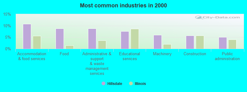
- Accommodation & food services (10.7%)
- Food (8.8%)
- Administrative & support & waste management services (8.8%)
- Educational services (7.5%)
- Machinery (6.0%)
- Construction (5.7%)
- Public administration (5.0%)
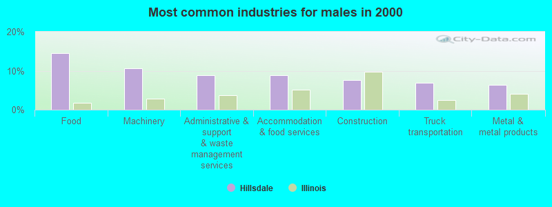
- Food (14.5%)
- Machinery (10.7%)
- Administrative & support & waste management services (8.8%)
- Accommodation & food services (8.8%)
- Construction (7.5%)
- Truck transportation (6.9%)
- Metal & metal products (6.3%)
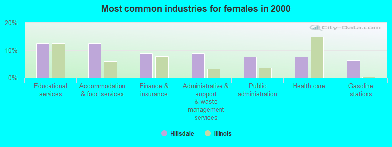
- Educational services (12.6%)
- Accommodation & food services (12.6%)
- Finance & insurance (8.8%)
- Administrative & support & waste management services (8.8%)
- Public administration (7.5%)
- Health care (7.5%)
- Gasoline stations (6.3%)
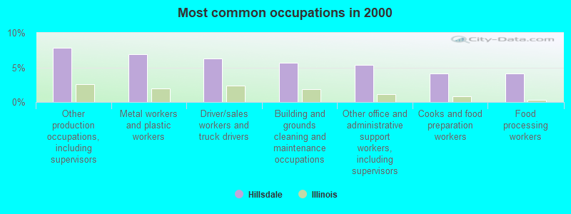
- Other production occupations, including supervisors (7.9%)
- Metal workers and plastic workers (6.9%)
- Driver/sales workers and truck drivers (6.3%)
- Building and grounds cleaning and maintenance occupations (5.7%)
- Other office and administrative support workers, including supervisors (5.3%)
- Cooks and food preparation workers (4.1%)
- Food processing workers (4.1%)
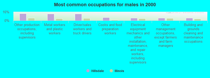
- Other production occupations, including supervisors (13.2%)
- Metal workers and plastic workers (12.6%)
- Driver/sales workers and truck drivers (12.6%)
- Cooks and food preparation workers (5.7%)
- Electrical equipment mechanics and other installation, maintenance, and repair workers, including supervisors (5.0%)
- Other management occupations, except farmers and farm managers (5.0%)
- Building and grounds cleaning and maintenance occupations (5.0%)
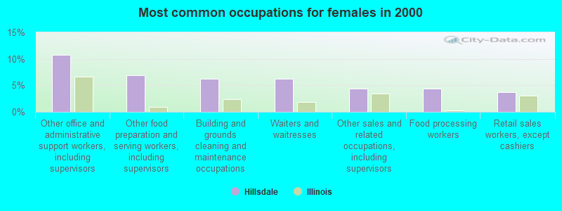
- Other office and administrative support workers, including supervisors (10.7%)
- Other food preparation and serving workers, including supervisors (6.9%)
- Building and grounds cleaning and maintenance occupations (6.3%)
- Waiters and waitresses (6.3%)
- Other sales and related occupations, including supervisors (4.4%)
- Food processing workers (4.4%)
- Retail sales workers, except cashiers (3.8%)
Average climate in Hillsdale, Illinois
Based on data reported by over 4,000 weather stations


(lower is better)
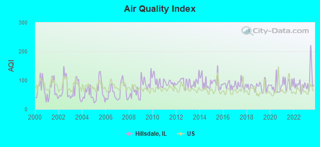
Air Quality Index (AQI) level in 2023 was 104. This is significantly worse than average.
| City: | 104 |
| U.S.: | 73 |
Carbon Monoxide (CO) [ppm] level in 2023 was 0.220. This is about average. Closest monitor was 18.6 miles away from the city center.
| City: | 0.220 |
| U.S.: | 0.251 |
Nitrogen Dioxide (NO2) [ppb] level in 2018 was 6.00. This is about average. Closest monitor was 15.0 miles away from the city center.
| City: | 6.00 |
| U.S.: | 5.11 |
Sulfur Dioxide (SO2) [ppb] level in 2023 was 0.251. This is significantly better than average. Closest monitor was 15.0 miles away from the city center.
| City: | 0.251 |
| U.S.: | 1.515 |
Ozone [ppb] level in 2023 was 33.8. This is about average. Closest monitor was 18.3 miles away from the city center.
| City: | 33.8 |
| U.S.: | 33.3 |
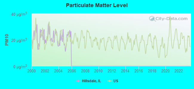
Particulate Matter (PM10) [µg/m3] level in 2005 was 21.7. This is about average. Closest monitor was 14.9 miles away from the city center.
| City: | 21.7 |
| U.S.: | 19.2 |
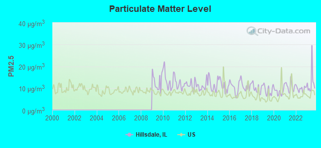
Particulate Matter (PM2.5) [µg/m3] level in 2023 was 12.7. This is significantly worse than average. Closest monitor was 14.9 miles away from the city center.
| City: | 12.7 |
| U.S.: | 8.1 |
Tornado activity:
Hillsdale-area historical tornado activity is near Illinois state average. It is 66% greater than the overall U.S. average.
On 3/29/1981, a category F4 (max. wind speeds 207-260 mph) tornado 12.5 miles away from the Hillsdale village center caused between $500,000 and $5,000,000 in damages.
On 3/13/1990, a category F3 (max. wind speeds 158-206 mph) tornado 5.6 miles away from the village center injured one person and caused between $50,000 and $500,000 in damages.
Earthquake activity:
Hillsdale-area historical earthquake activity is significantly above Illinois state average. It is 110% greater than the overall U.S. average.On 4/18/2008 at 09:36:59, a magnitude 5.4 (5.1 MB, 4.8 MS, 5.4 MW, 5.2 MW, Class: Moderate, Intensity: VI - VII) earthquake occurred 249.8 miles away from the city center
On 6/10/1987 at 23:48:54, a magnitude 5.1 (4.9 MB, 4.4 MS, 4.6 MS, 5.1 LG) earthquake occurred 227.6 miles away from the city center
On 4/18/2008 at 09:36:59, a magnitude 5.2 (5.2 MW, Depth: 8.9 mi) earthquake occurred 249.8 miles away from the city center
On 6/28/2004 at 06:10:52, a magnitude 4.2 (4.2 MW, Depth: 6.2 mi, Class: Light, Intensity: IV - V) earthquake occurred 66.8 miles away from the city center
On 6/18/2002 at 17:37:15, a magnitude 5.0 (4.3 MB, 4.6 MW, 5.0 LG) earthquake occurred 281.0 miles away from the city center
On 4/18/2008 at 15:14:16, a magnitude 4.8 (4.5 MB, 4.8 MW, 4.6 MW) earthquake occurred 249.3 miles away from the city center
Magnitude types: regional Lg-wave magnitude (LG), body-wave magnitude (MB), surface-wave magnitude (MS), moment magnitude (MW)
Natural disasters:
The number of natural disasters in Rock Island County (14) is near the US average (15).Major Disasters (Presidential) Declared: 11
Emergencies Declared: 1
Causes of natural disasters: Floods: 11, Storms: 9, Hurricane: 1, Snowstorm: 1, Tornado: 1, Wind: 1, Winter Storm: 1, Other: 1 (Note: some incidents may be assigned to more than one category).
Hospitals and medical centers near Hillsdale:
- QUAD CITIES KIDNEY CENTER - GENESEO (Dialysis Facility, about 11 miles away; GENESEO, IL)
- HOME HLTH SVCE OF HAMMOND HENR (Home Health Center, about 11 miles away; GENESEO, IL)
- HAMMOND-HENRY DISTRICT HSP (Nursing Home, about 11 miles away; GENESEO, IL)
- GOOD SAMARITAN SOCIETY - GENESEO VILLAGE (Nursing Home, about 12 miles away; GENESEO, IL)
- GOOD SAMARITAN SOCIETY - PROPHETS RIVERVIEW (Nursing Home, about 13 miles away; PROPHETSTOWN, IL)
- STRIVE (Hospital, about 14 miles away; PROPHETSTOWN, IL)
- RIVERVIEW MANOR (Nursing Home, about 14 miles away; PLEASANT VALLEY, IA)
Airports located in Hillsdale:
- Black Airport (9IL7) (Runways: 2)
Operable nuclear power plants near Hillsdale:
- 9 miles: Quad Cities 1 and 2 in Cordova, IL.
Colleges/universities with over 2000 students nearest to Hillsdale:
- Ashford University (about 17 miles; Clinton, IA; Full-time enrollment: 73,330)
- Black Hawk College (about 18 miles; Moline, IL; FT enrollment: 5,086)
- Kaplan University-Davenport Campus (about 20 miles; Davenport, IA; FT enrollment: 60,376)
- Augustana College (about 22 miles; Rock Island, IL; FT enrollment: 2,555)
- Saint Ambrose University (about 22 miles; Davenport, IA; FT enrollment: 3,053)
- Eastern Iowa Community College District (about 22 miles; Davenport, IA; FT enrollment: 5,507)
- Illinois Valley Community College (about 60 miles; Oglesby, IL; FT enrollment: 2,747)
Points of interest:
Notable location: Hillsdale Fire Protection District (A). Display/hide its location on the map
Drinking water stations with addresses in Hillsdale and their reported violations in the past:
PRIME STEAKHOUSE (Population served: 75, Groundwater):Past health violations:HILL & DELL OIL COMPANIES (Population served: 50, Groundwater):
- MCL, Monthly (TCR) - Between JAN-2006 and DEC-2006, Contaminant: Coliform. Follow-up actions: St Public Notif requested (SEP-14-2006), St Formal NOV issued (SEP-14-2006), St Public Notif received (SEP-14-2006), St Compliance achieved (DEC-08-2006)
Past health violations:Past monitoring violations:
- MCL, Monthly (TCR) - Between JUL-2006 and SEP-2006, Contaminant: Coliform. Follow-up actions: St Formal NOV issued (AUG-25-2006), St Public Notif received (AUG-25-2006), St Public Notif requested (AUG-25-2006), St Compliance achieved (SEP-15-2006)
- One routine major monitoring violation
Drinking water stations with addresses in Hillsdale that have no violations reported:
- HILLSDALE AMERICAN LEGION (Population served: 50, Primary Water Source Type: Groundwater)
| This village: | 2.5 people |
| Illinois: | 2.6 people |
| This village: | 70.6% |
| Whole state: | 65.8% |
| This village: | 11.8% |
| Whole state: | 6.3% |
No gay or lesbian households reported
Banks with branches in Hillsdale (2011 data):
- First Trust & Savings Bank of Albany, Illinois: Hillsdale Branch at 230 Main Street, branch established on 1903/12/10. Info updated 2006/10/13: Bank assets: $164.1 mil, Deposits: $143.5 mil, headquarters in Albany, IL, positive income, Agricultural Specialization, 3 total offices, Holding Company: Albany Bancshares, Inc.
For population 15 years and over in Hillsdale:
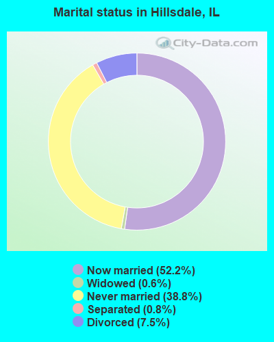
- Never married: 38.8%
- Now married: 52.2%
- Separated: 0.8%
- Widowed: 0.6%
- Divorced: 7.5%
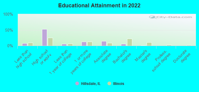
For population 25 years and over in Hillsdale:
- High school or higher: 87.7%
- Bachelor's degree or higher: 6.9%
- Graduate or professional degree: 1.2%
- Unemployed: 4.8%
- Mean travel time to work (commute): 25.7 minutes
| Here: | 7.2 |
| Illinois average: | 12.5 |
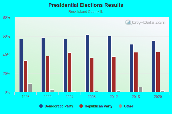
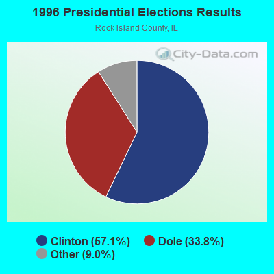
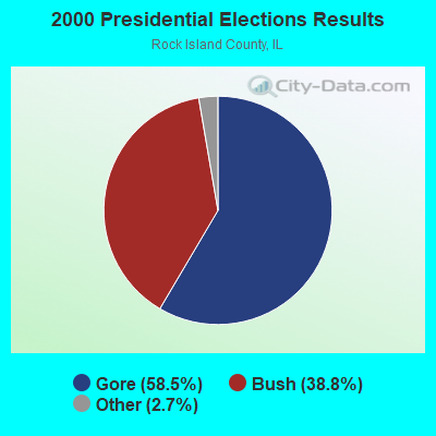
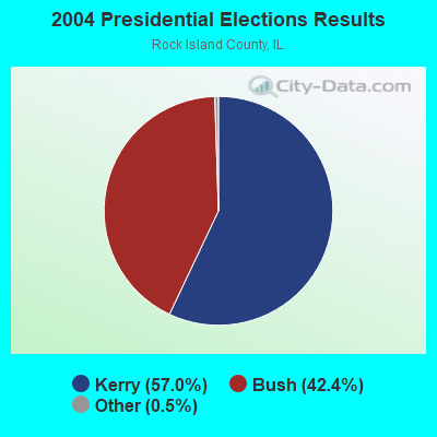
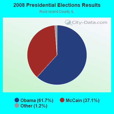
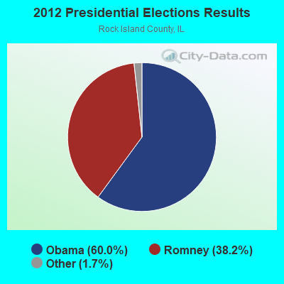
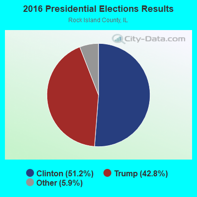

Graphs represent county-level data. Detailed 2008 Election Results
Religion statistics for Hillsdale, IL (based on Rock Island County data)
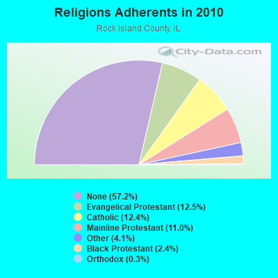
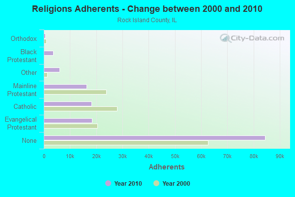
| Religion | Adherents | Congregations |
|---|---|---|
| Evangelical Protestant | 18,447 | 90 |
| Catholic | 18,258 | 14 |
| Mainline Protestant | 16,294 | 52 |
| Other | 6,037 | 12 |
| Black Protestant | 3,577 | 9 |
| Orthodox | 475 | 2 |
| None | 84,458 | - |
Food Environment Statistics:
| Rock Island County: | 1.56 / 10,000 pop. |
| Illinois: | 2.24 / 10,000 pop. |
| Rock Island County: | 0.07 / 10,000 pop. |
| State: | 0.08 / 10,000 pop. |
| This county: | 0.88 / 10,000 pop. |
| Illinois: | 0.75 / 10,000 pop. |
| Rock Island County: | 4.01 / 10,000 pop. |
| Illinois: | 2.61 / 10,000 pop. |
| Here: | 7.54 / 10,000 pop. |
| State: | 6.86 / 10,000 pop. |
| Rock Island County: | 9.3% |
| Illinois: | 8.3% |
| Here: | 26.9% |
| Illinois: | 25.2% |
| Rock Island County: | 7.5% |
| Illinois: | 14.5% |
Health and Nutrition:
| Hillsdale: | 52.8% |
| Illinois: | 49.5% |
| This city: | 53.0% |
| Illinois: | 47.2% |
| Here: | 28.4 |
| Illinois: | 28.6 |
| Hillsdale: | 22.1% |
| Illinois: | 20.5% |
| This city: | 7.7% |
| Illinois: | 10.8% |
| This city: | 6.9 |
| Illinois: | 6.8 |
| Hillsdale: | 35.7% |
| State: | 33.4% |
| This city: | 60.5% |
| Illinois: | 56.4% |
| Hillsdale: | 80.7% |
| Illinois: | 79.9% |
More about Health and Nutrition of Hillsdale, IL Residents
| Local government employment and payroll (March 2022) | |||||
| Function | Full-time employees | Monthly full-time payroll | Average yearly full-time wage | Part-time employees | Monthly part-time payroll |
|---|---|---|---|---|---|
| Other Government Administration | 0 | $0 | 9 | $2,905 | |
| Streets and Highways | 0 | $0 | 1 | $793 | |
| Sewerage | 0 | $0 | 1 | $900 | |
| Totals for Government | 0 | $0 | 11 | $4,598 | |
Hillsdale government finances - Expenditure in 2017 (per resident):
- Current Operations - General - Other: $68,000 ($166.67)
Regular Highways: $57,000 ($139.71)
Financial Administration: $57,000 ($139.71)
Police Protection: $45,000 ($110.29)
Parks and Recreation: $13,000 ($31.86)
- General - Interest on Debt: $3,000 ($7.35)
- Total Salaries and Wages: $81,000 ($198.53)
Hillsdale government finances - Revenue in 2017 (per resident):
- Charges - Sewerage: $60,000 ($147.06)
- Miscellaneous - General Revenue - Other: $2,000 ($4.90)
Fines and Forfeits: $1,000 ($2.45)
- State Intergovernmental - General Local Government Support: $192,000 ($470.59)
Highways: $13,000 ($31.86)
- Tax - Property: $47,000 ($115.20)
Public Utilities Sales: $19,000 ($46.57)
Other License: $2,000 ($4.90)
Hillsdale government finances - Debt in 2017 (per resident):
- Long Term Debt - Beginning Outstanding - Unspecified Public Purpose: $82,000 ($200.98)
Outstanding Unspecified Public Purpose: $61,000 ($149.51)
Retired Unspecified Public Purpose: $21,000 ($51.47)
Hillsdale government finances - Cash and Securities in 2017 (per resident):
- Other Funds - Cash and Securities: $136,000 ($333.33)
- Sinking Funds - Cash and Securities: $9,000 ($22.06)
Businesses in Hillsdale, IL
- Subway: 1
Strongest AM radio stations in Hillsdale:
- WOC (1420 AM; 5 kW; DAVENPORT, IA; Owner: CITICASTERS LICENSES, L.P.)
- WKBF (1270 AM; 5 kW; ROCK ISLAND, IL; Owner: MERCURY BROADCASTING COMPANY, INC.)
- WSCR (670 AM; 50 kW; CHICAGO, IL; Owner: INFINITY BROADCASTING OPERATIONS, INC.)
- WGN (720 AM; 50 kW; CHICAGO, IL; Owner: WGN CONTINENTAL BROADCASTING CO.)
- WBBM (780 AM; 50 kW; CHICAGO, IL; Owner: INFINITY BROADCASTING OPERATIONS, INC.)
- WTMJ (620 AM; 50 kW; MILWAUKEE, WI; Owner: JOURNAL BROADCAST CORPORATION)
- WMVP (1000 AM; 50 kW; CHICAGO, IL; Owner: ABC, INC.)
- WLS (890 AM; 50 kW; CHICAGO, IL; Owner: WLS, INC.)
- WYLL (1160 AM; 50 kW; CHICAGO, IL; Owner: SCA LICENSE CORPORATION)
- WDLM (960 AM; 1 kW; EAST MOLINE, IL; Owner: THE MOODY BIBLE INSTITUTE OF CHICAGO)
- KROS (1340 AM; 1 kW; CLINTON, IA; Owner: KROS BROADCASTING, INC.)
- WISN (1130 AM; 50 kW; MILWAUKEE, WI; Owner: CAPSTAR TX LIMITED PARTNERSHIP)
- KXEL (1540 AM; 50 kW; WATERLOO, IA; Owner: KXEL BROADCASTING COMPANY, INC.)
Strongest FM radio stations in Hillsdale:
- KUUL (101.3 FM; EAST MOLINE, IL; Owner: CITICASTERS LICENSES, L.P.)
- KCQQ (106.5 FM; DAVENPORT, IA; Owner: CITICASTERS LICENSES, L.P.)
- KMXG (96.1 FM; CLINTON, IA; Owner: CITICASTERS LICENSES, L.P.)
- WLLR-FM (103.7 FM; DAVENPORT, IA; Owner: CITICASTERS LICENSES, L.P.)
- WVIK (90.3 FM; ROCK ISLAND, IL; Owner: AUGUSTANA COLLEGE)
- WHTS (98.9 FM; ROCK ISLAND, IL; Owner: MERCURY BROADCASTING COMPANY, INC.)
- WAXR (88.1 FM; GENESEO, IL; Owner: AMERICAN FAMILY ASSOCIATION)
- WDLM-FM (89.3 FM; EAST MOLINE, IL; Owner: THE MOODY BIBLE INSTITUTE OF CHICAGO)
- KORB (93.5 FM; BETTENDORF, IA; Owner: CUMULUS LICENSING CORP.)
- WXLP (96.9 FM; MOLINE, IL; Owner: CUMULUS LICENSING CORP.)
- KBOB-FM (104.9 FM; GENESEO, IL; Owner: CUMULUS LICENSING CORP.)
- WZZT (95.1 FM; MORRISON, IL; Owner: W. RUSSELL WITHERS, JR.)
- WYEC (93.9 FM; KEWANEE, IL; Owner: VIRDEN BROADCASTING CORPORATION)
- KZEG (94.7 FM; CLINTON, IA; Owner: WPW BROADCASTING, INC.)
TV broadcast stations around Hillsdale:
- WHBF-TV (Channel 4; ROCK ISLAND, IL; Owner: CORONET COMMUNICATIONS COMPANY)
- WBQD-LP (Channel 26; DAVENPORT, IA; Owner: FOUR SEASONS PEORIA, LLC)
- KWQC-TV (Channel 6; DAVENPORT, IA; Owner: YOUNG BROADCASTING OF DAVENPORT, INC.)
- KLJB-TV (Channel 18; DAVENPORT, IA; Owner: QUAD CITIES TELEVISION ACQUISITION CORP.)
- WQAD-TV (Channel 8; MOLINE, IL; Owner: NEW YORK TIMES MANAGEMENT SERVICES)
- K61HD (Channel 61; DAVENPORT, IA; Owner: TRINITY BROADCASTING NETWORK)
- WQPT-TV (Channel 24; MOLINE, IL; Owner: BLACK HAWK COLLEGE)
- KQIN (Channel 36; DAVENPORT, IA; Owner: IOWA PUBLIC BROADCASTING BOARD)
Hillsdale fatal accident list:
- National Bridge Inventory (NBI) Statistics
- 41Number of bridges
- 604ft / 184mTotal length
- $48,000Total costs
- 193,250Total average daily traffic
- 53,498Total average daily truck traffic
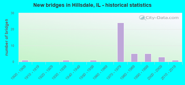
- New bridges - historical statistics
- 11900-1909
- 11930-1939
- 11950-1959
- 241970-1979
- 51980-1989
- 51990-1999
- 32000-2009
- 12010-2019
FCC Registered Antenna Towers:
21 (See the full list of FCC Registered Antenna Towers in Hillsdale)FCC Registered Broadcast Land Mobile Towers:
5- Bnsf Mp 56.36 (Lat: 41.613361 Lon: -90.173444), Type: Pole, Structure height: 12 m, Overall height: 15 m, Call Sign: WPNW539,
Assigned Frequencies: 896.887 MHz, 896.937 MHz, 896.987 MHz, 897.887 MHz, 897.937 MHz, 897.987 MHz, Grant Date: 07/16/1999, Expiration Date: 07/16/2004, Cancellation Date: 09/26/2004, Certifier: Robert Vandeberg, Registrant: Bnsf, 55500 D O T Rd, Pueblo, CO 81001, Fax: (719) 584-0767
- Lat: 41.652528 Lon: -90.216222, Call Sign: WQOX377,
Assigned Frequencies: 151.805 MHz, Grant Date: 02/04/2022, Expiration Date: 02/23/2032, Certifier: Allen Black, Registrant: Washington Radio Reports, Gettysburg, PA 17325, Phone: (717) 334-0668, Fax: (717) 334-6440, Email:
- Lat: 41.628889 Lon: -90.198889, Call Sign: WQTS402,
Assigned Frequencies: 456.850 MHz, 457.050 MHz, 469.212 MHz, Grant Date: 04/02/2014, Expiration Date: 04/02/2024, Certifier: Alan Falk, Registrant: Midwest Wireless, 5915 N Brady Street, Davenport, IA 52806, Phone: (563) 386-7344, Fax: (563) 386-9011, Email:
- Lat: 41.598889 Lon: -90.247778, Call Sign: WQUL998,
Assigned Frequencies: 154.490 MHz, 157.710 MHz, 160.027 MHz, 159.607 MHz, Grant Date: 08/13/2014, Expiration Date: 08/13/2024, Certifier: Todd Declercq, Registrant: Midwest Wireless, 5915 N Brady Street, Davenport, IA 52806, Phone: (563) 386-7344, Fax: (563) 386-9011, Email:
- 29713 Route 2 N (Lat: 41.591222 Lon: -90.210889), Call Sign: WRUX656,
Assigned Frequencies: 464.062 MHz, 469.062 MHz, 464.112 MHz, 469.112 MHz, 464.162 MHz, Grant Date: 10/15/2022, Expiration Date: 10/15/2032, Certifier: Matthew Seefeldt, Registrant: Buytwowayradios.Com, 528 S Cherry Rd, Rock Hill, SC 29732, Phone: (803) 818-2228, Fax: (803) 985-8775, Email:
FCC Registered Microwave Towers:
7- HILLSDALE, 9105 305th Street North (Lat: 41.610083 Lon: -90.195111), Type: Tower, Structure height: 54.9 m, Overall height: 59.1 m, Call Sign: WQHB868,
Assigned Frequencies: 6795.00 MHz, Grant Date: 06/22/2007, Expiration Date: 06/22/2017, Cancellation Date: 06/03/2016, Certifier: Steven T Campbell, Registrant: Holland & Knight LLP, 800 17th Street, N.W., Suite #1100, Washington, DC 20006-3906, Phone: (202) 955-3000, Fax: (202) 955-5564, Email:
- CANOE CREEK, 73rd Ave. North & Il Route 2 (303673) (Lat: 41.588333 Lon: -90.211944), Type: Mast, Structure height: 88.1 m, Overall height: 89.6 m, Call Sign: WQQT582,
Assigned Frequencies: 6197.24 MHz, Grant Date: 04/18/2023, Expiration Date: 02/27/2033, Certifier: Gregory M Romano, Registrant: Verizon, 5055 North Point Pkwy, Alpharetta, GA 30022, Phone: (770) 797-1070, Email:
- DIETZ PROPERTY, 3409 265th Street North (Lat: 41.553000 Lon: -90.251750), Type: Mtower, Structure height: 57.9 m, Overall height: 60.7 m, Call Sign: WQTP920,
Assigned Frequencies: 11225.0 MHz, 11265.0 MHz, Grant Date: 02/13/2024, Expiration Date: 03/20/2034, Certifier: John Monday, Registrant: At&t Services, Inc., 208 S Akard St, 20f, Dallas, TX 75202, Phone: (855) 699-7073, Email:
- AM TWR 50651, 9105 305th Street (Lat: 41.610083 Lon: -90.195139), Type: Ltower, Structure height: 59.1 m, Call Sign: WQTV551,
Assigned Frequencies: 11305.0 MHz, 11385.0 MHz, Grant Date: 03/19/2024, Expiration Date: 04/22/2034, Certifier: John Monday, Registrant: At&t Services, Inc., 208 S Akard St, 20f, Dallas, TX 75202, Phone: (855) 699-7073, Email:
- IL-HILLSD-CN-1, 127 Butzer St (Lat: 41.614500 Lon: -90.172806), Type: Silo, Structure height: 42.7 m, Overall height: 45.7 m, Call Sign: WRDE649,
Assigned Frequencies: 10915.0 MHz, 10915.0 MHz, 10915.0 MHz, 10915.0 MHz, 10915.0 MHz, 10915.0 MHz, 10915.0 MHz, 10915.0 MHz, 10995.0 MHz, 19380.0 MHz... (+27 more), Grant Date: 04/10/2019, Expiration Date: 04/10/2029, Certifier: Eric S Pyland, Registrant: Amg Technology Investment Group, LLC, 95 Parker Oaks Lane, Hudson Oaks, TX 76087, Phone: (855) 698-5465, Email:
- IL-GENESENE2, N 2850th Ave (Lat: 41.561722 Lon: -90.077750), Type: Silo, Structure height: 41.1 m, Overall height: 43.1 m, Call Sign: WRMJ633,
Assigned Frequencies: 10915.0 MHz, 10915.0 MHz, 10915.0 MHz, 10915.0 MHz, 10915.0 MHz, 10915.0 MHz, 10915.0 MHz, 10915.0 MHz, 10915.0 MHz, 10915.0 MHz, 10915.0 MHz, Grant Date: 04/20/2021, Expiration Date: 04/20/2031, Certifier: Jack Marsh, Registrant: Amg Technology Investment Group, LLC, 95 Parker Oaks Lane, Hudson Oaks, TX 76087, Phone: (855) 698-5465, Email:
- HILLSDALENW1, 277th St N (Lat: 41.639500 Lon: -90.239722), Type: Silo, Structure height: 27.4 m, Overall height: 29.4 m, Call Sign: WRNQ879,
Assigned Frequencies: 11565.0 MHz, 11565.0 MHz, 11565.0 MHz, 11565.0 MHz, 11565.0 MHz, 11565.0 MHz, 11565.0 MHz, 11565.0 MHz, 11565.0 MHz, 11565.0 MHz, Grant Date: 08/10/2021, Expiration Date: 08/10/2031, Certifier: Jack Marsh, Registrant: Amg Technology Investment Group, LLC, 95 Parker Oaks Lane, Hudson Oaks, TX 76087, Phone: (855) 698-5465, Email:
FCC Registered Amateur Radio Licenses:
6- Call Sign: KB9ELZ, Grant Date: 04/10/1990, Expiration Date: 04/10/2000, Cancellation Date: 04/11/2002, Registrant: Sheryl A Bridges, 410 Jackson St, Hillsdale, IL 61257
- Call Sign: KY9C, Previous Call Sign: WB9WSU, Grant Date: 06/01/1993, Expiration Date: 06/01/2003, Cancellation Date: 06/02/2005, Registrant: Stanley L Brown, Box 83, Hillsdale, IL 61257
- Call Sign: N9TPS, Licensee ID: L00644029, Grant Date: 02/24/2003, Expiration Date: 05/25/2013, Cancellation Date: 05/27/2015, Certifier: James A Larrenz, Registrant: James A Larrenz, 127 Butzer St, Hillsdale, IL 61257
- Call Sign: N9XBH, Licensee ID: L00866898, Grant Date: 05/21/2004, Expiration Date: 06/14/2014, Cancellation Date: 06/15/2016, Certifier: Diane N Larvenz, Registrant: Diane N Larvenz, 127 Butzer St, Hillsdale, IL 61257
- Call Sign: WB4RSY, Grant Date: 12/18/1990, Expiration Date: 12/18/2000, Cancellation Date: 12/19/2002, Registrant: Oval E Vernia, 2700 290th St N, Hillsdale, IL 61257
- Call Sign: WB9WSO, Grant Date: 06/01/1993, Expiration Date: 06/01/2003, Cancellation Date: 06/02/2005, Registrant: Judith D Brown, Box 83, Hillsdale, IL 61257
| Home Mortgage Disclosure Act Aggregated Statistics For Year 2009 (Based on 1 partial tract) | ||
| C) Refinancings | ||
|---|---|---|
| Number | Average Value | |
| LOANS ORIGINATED | 2 | $149,420 |
| APPLICATIONS APPROVED, NOT ACCEPTED | 0 | $0 |
| APPLICATIONS DENIED | 0 | $0 |
| APPLICATIONS WITHDRAWN | 0 | $0 |
| FILES CLOSED FOR INCOMPLETENESS | 0 | $0 |
Detailed HMDA statistics for the following Tracts: 0201.00
2002 - 2018 National Fire Incident Reporting System (NFIRS) incidents
- Fire incident types reported to NFIRS in Hillsdale, IL
- 10042.6%Outside Fires
- 7029.8%Structure Fires
- 3715.7%Mobile Property/Vehicle Fires
- 2811.9%Other
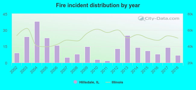 According to the data from the years 2002 - 2018 the average number of fires per year is 14. The highest number of reported fires - 38 took place in 2004, and the least - 2 in 2011. The data has a declining trend.
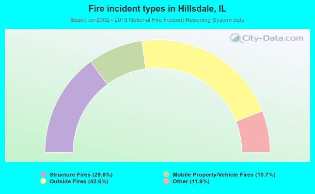 When looking into fire subcategories, the most incidents belonged to: Outside Fires (42.6%), and Structure Fires (29.8%).
| Most common first names in Hillsdale, IL among deceased individuals | ||
| Name | Count | Lived (average) |
|---|---|---|
| John | 14 | 79.6 years |
| Robert | 10 | 72.0 years |
| Charles | 9 | 74.7 years |
| Dorothy | 6 | 78.5 years |
| Howard | 6 | 75.5 years |
| George | 6 | 79.3 years |
| William | 6 | 74.7 years |
| Fred | 5 | 78.4 years |
| James | 5 | 74.6 years |
| Leonard | 5 | 71.8 years |
| Most common last names in Hillsdale, IL among deceased individuals | ||
| Last name | Count | Lived (average) |
|---|---|---|
| Kessler | 7 | 77.0 years |
| Johnson | 7 | 75.2 years |
| Davis | 6 | 73.7 years |
| Hart | 6 | 76.5 years |
| Falk | 6 | 77.7 years |
| Dillin | 5 | 66.2 years |
| Fillmer | 4 | 77.5 years |
| Feaster | 4 | 89.3 years |
| Hanna | 4 | 74.7 years |
| Mcconnell | 4 | 79.5 years |
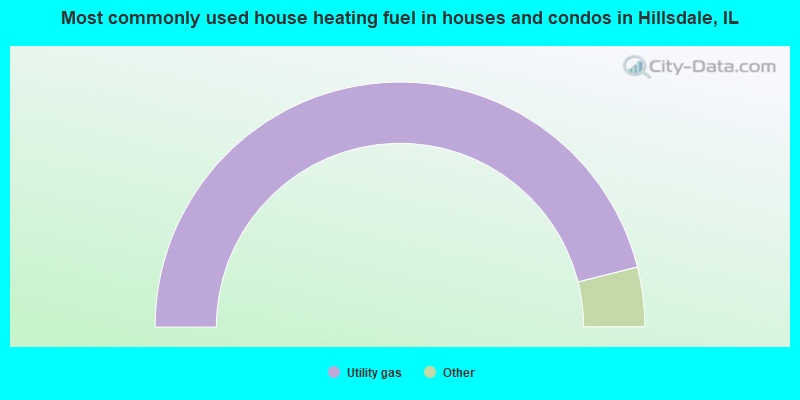
- 92.4%Utility gas
- 2.5%Electricity
- 2.5%Other fuel
- 1.3%Wood
- 1.3%No fuel used
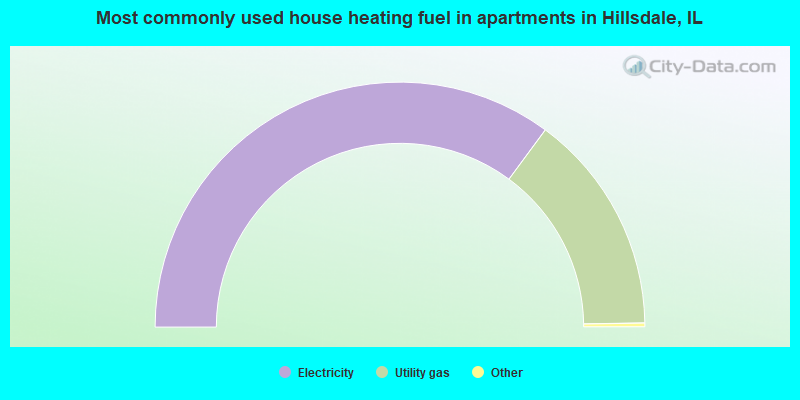
- 70.6%Electricity
- 29.4%Utility gas
Hillsdale compared to Illinois state average:
- Median house value significantly below state average.
- Unemployed percentage significantly below state average.
- Black race population percentage significantly below state average.
- Hispanic race population percentage below state average.
- Foreign-born population percentage significantly below state average.
- Number of college students below state average.
- Percentage of population with a bachelor's degree or higher significantly below state average.

|
Total of 42 patent applications in 2008-2024.