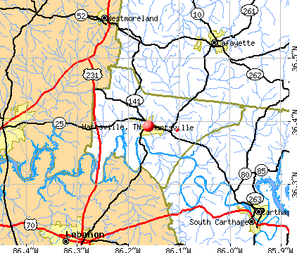
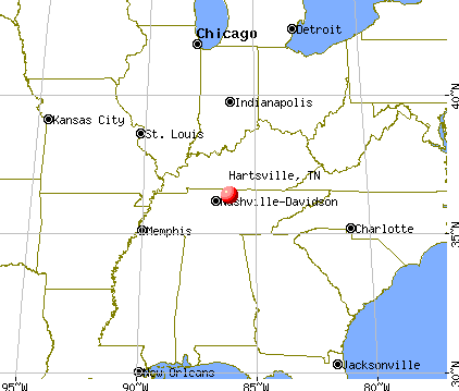
Hartsville, Tennessee
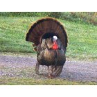
Hartsville: Tom in the driveway - Hartsville - Spring
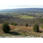
Hartsville: Road side view on Int 75 leavingTn. (TN. Valley )
- add
your
Submit your own pictures of this town and show them to the world
- OSM Map
- General Map
- Google Map
- MSN Map
| Males: 1,178 | |
| Females: 1,348 |
| Median resident age: | 39.3 years |
| Tennessee median age: | 35.9 years |
Zip codes: 37074.
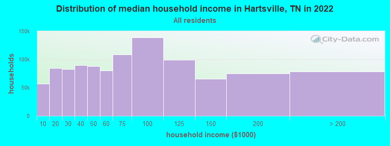
| Hartsville: | $52,575 |
| TN: | $65,254 |
Estimated per capita income in 2022: $24,261 (it was $14,226 in 2000)
Hartsville town income, earnings, and wages data
Estimated median house or condo value in 2022: $226,561 (it was $66,500 in 2000)
| Hartsville: | $226,561 |
| TN: | $284,800 |
Mean prices in 2022: all housing units: $250,196; detached houses: $280,178; mobile homes: $106,699
Detailed information about poverty and poor residents in Hartsville, TN


- 1,79875.1%White alone
- 53822.5%Black alone
- 351.5%Hispanic
- 110.5%Two or more races
- 70.3%American Indian alone
- 50.2%Asian alone
- 10.04%Native Hawaiian and Other
Pacific Islander alone
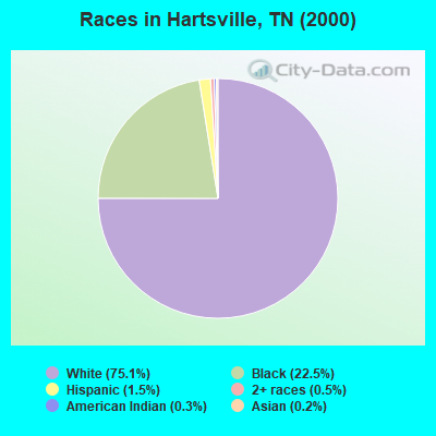
Races in Hartsville detailed stats: ancestries, foreign born residents, place of birth
According to our research of Tennessee and other state lists, there were 518 registered sex offenders living in Hartsville, Tennessee as of May 17, 2024.
The ratio of all residents to sex offenders in Hartsville is 5 to 1.
 Recent articles from our blog. Our writers, many of them Ph.D. graduates or candidates, create easy-to-read articles on a wide variety of topics.

 | Tennessee's 2020 Census results (70 replies) |
| 2019 TN Population Estimates (19 replies) |
| Population Projections for 2040 (8 replies) |
| Should the City of Cookeville and Putnam County be consolidated? (13 replies) |
| Bethpage or Hartsville? (3 replies) |
| Why are the county roads so poor in western Putnam County? (7 replies) |
Latest news from Hartsville, TN collected exclusively by city-data.com from local newspapers, TV, and radio stations
Ancestries: United States (15.3%), English (11.3%), Irish (5.0%), Subsaharan African (2.9%), German (2.4%), Scotch-Irish (1.3%).
Current Local Time: CST time zone
Incorporated in 1833
Elevation: 474 feet
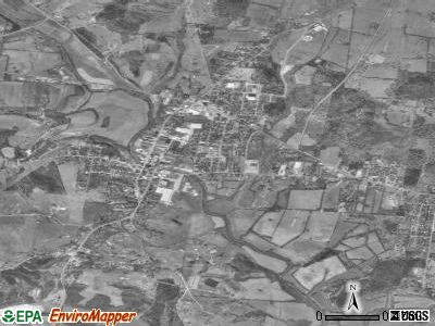
Land area: 3.56 square miles.
Population density: 710 people per square mile (low).
37 residents are foreign born
| This town: | 1.5% |
| Tennessee: | 2.8% |
| Hartsville town: | 0.9% ($629) |
| Tennessee: | 0.8% ($715) |
Nearest city with pop. 50,000+: Nashville-Davidson, TN  (37.3 miles , pop. 545,524).
Nearest city with pop. 1,000,000+: Chicago, IL (385.6 miles , pop. 2,896,016).
Nearest cities:
), ), ), ), ), ), Latitude: 36.39 N, Longitude: 86.16 W
Area code: 615
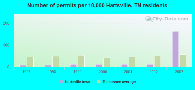
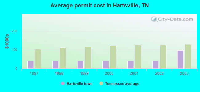
Single-family new house construction building permits:
- 2003: 39 buildings, average cost: $95,600
- 2002: 3 buildings, average cost: $39,000
- 2001: 3 buildings, average cost: $39,000
- 2000: 3 buildings, average cost: $39,000
- 1999: 3 buildings, average cost: $39,000
- 1998: 2 buildings, average cost: $39,000
- 1997: 2 buildings, average cost: $39,000
| Here: | 3.0% |
| Tennessee: | 3.0% |

- Construction (10.0%)
- Health care (9.5%)
- Educational services (8.0%)
- Leather & allied products (5.0%)
- Professional, scientific, technical services (4.7%)
- Accommodation & food services (3.8%)
- Public administration (3.7%)
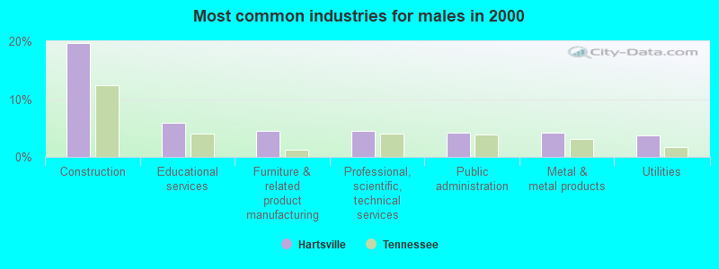
- Construction (19.8%)
- Educational services (5.9%)
- Furniture & related product manufacturing (4.5%)
- Professional, scientific, technical services (4.5%)
- Public administration (4.2%)
- Metal & metal products (4.2%)
- Utilities (3.8%)
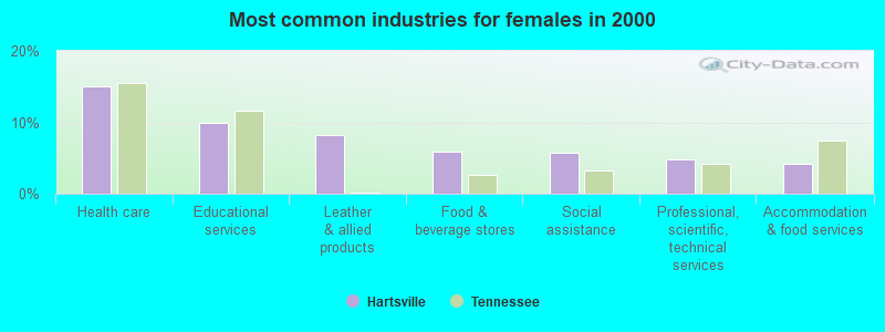
- Health care (15.1%)
- Educational services (10.0%)
- Leather & allied products (8.3%)
- Food & beverage stores (5.9%)
- Social assistance (5.7%)
- Professional, scientific, technical services (4.9%)
- Accommodation & food services (4.2%)
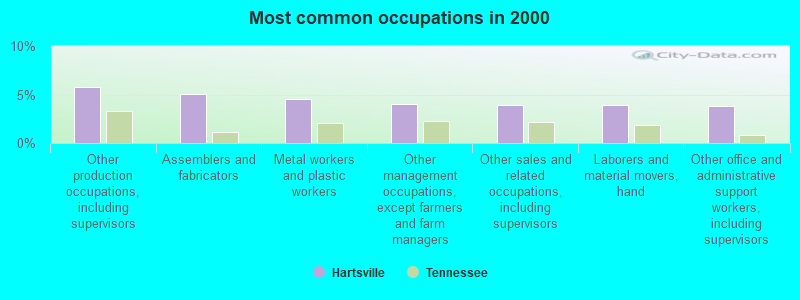
- Other production occupations, including supervisors (5.8%)
- Assemblers and fabricators (5.0%)
- Metal workers and plastic workers (4.6%)
- Other management occupations, except farmers and farm managers (4.0%)
- Other sales and related occupations, including supervisors (3.9%)
- Laborers and material movers, hand (3.9%)
- Other office and administrative support workers, including supervisors (3.8%)
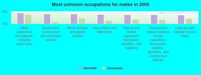
- Other production occupations, including supervisors (7.1%)
- Supervisors, construction and extraction workers (6.4%)
- Metal workers and plastic workers (6.4%)
- Assemblers and fabricators (6.1%)
- Vehicle and mobile equipment mechanics, installers, and repairers (5.9%)
- Construction traders workers except carpenters, electricians, painters, plumbers, and construction laborers (5.9%)
- Laborers and material movers, hand (5.6%)
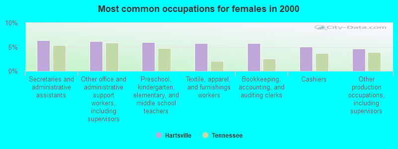
- Secretaries and administrative assistants (6.4%)
- Other office and administrative support workers, including supervisors (6.2%)
- Preschool, kindergarten, elementary, and middle school teachers (5.9%)
- Textile, apparel, and furnishings workers (5.7%)
- Bookkeeping, accounting, and auditing clerks (5.7%)
- Cashiers (5.1%)
- Other production occupations, including supervisors (4.7%)
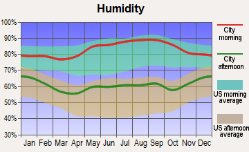
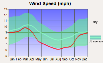
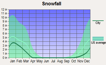
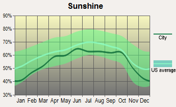
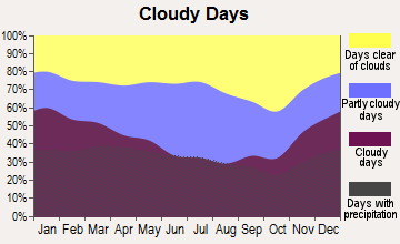
Average climate in Hartsville, Tennessee
Based on data reported by over 4,000 weather stations
|
|

(lower is better)
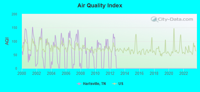
Air Quality Index (AQI) level in 2012 was 81.3. This is about average.
| City: | 81.3 |
| U.S.: | 72.6 |
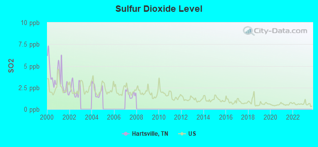
Sulfur Dioxide (SO2) [ppb] level in 2007 was 1.77. This is about average. Closest monitor was 12.1 miles away from the city center.
| City: | 1.77 |
| U.S.: | 1.51 |
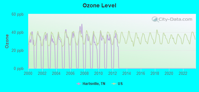
Ozone [ppb] level in 2012 was 31.9. This is about average. Closest monitor was 22.9 miles away from the city center.
| City: | 31.9 |
| U.S.: | 33.3 |
Tornado activity:
Hartsville-area historical tornado activity is slightly above Tennessee state average. It is 63% greater than the overall U.S. average.
On 4/27/1970, a category F4 (max. wind speeds 207-260 mph) tornado 16.0 miles away from the Hartsville town center killed 3 people and injured 85 people and caused between $500,000 and $5,000,000 in damages.
On 4/16/1998, a category F3 (max. wind speeds 158-206 mph) tornado 2.7 miles away from the town center killed one person and injured 60 people and caused $101 million in damages.
Earthquake activity:
Hartsville-area historical earthquake activity is significantly above Tennessee state average. It is 164% greater than the overall U.S. average.On 4/18/2008 at 09:36:59, a magnitude 5.4 (5.1 MB, 4.8 MS, 5.4 MW, 5.2 MW, Class: Moderate, Intensity: VI - VII) earthquake occurred 171.2 miles away from the city center
On 4/18/2008 at 09:36:59, a magnitude 5.2 (5.2 MW, Depth: 8.9 mi) earthquake occurred 171.1 miles away from Hartsville center
On 7/27/1980 at 18:52:21, a magnitude 5.2 (5.1 MB, 4.7 MS, 5.0 UK, 5.2 UK) earthquake occurred 175.0 miles away from Hartsville center
On 6/18/2002 at 17:37:15, a magnitude 5.0 (4.3 MB, 4.6 MW, 5.0 LG) earthquake occurred 141.9 miles away from Hartsville center
On 4/29/2003 at 08:59:39, a magnitude 4.9 (4.4 MB, 4.6 MW, 4.9 LG, Class: Light, Intensity: IV - V) earthquake occurred 134.6 miles away from Hartsville center
On 6/10/1987 at 23:48:54, a magnitude 5.1 (4.9 MB, 4.4 MS, 4.6 MS, 5.1 LG) earthquake occurred 192.8 miles away from Hartsville center
Magnitude types: regional Lg-wave magnitude (LG), body-wave magnitude (MB), surface-wave magnitude (MS), moment magnitude (MW)
Natural disasters:
The number of natural disasters in Trousdale County (9) is smaller than the US average (15).Major Disasters (Presidential) Declared: 6
Emergencies Declared: 2
Causes of natural disasters: Floods: 4, Storms: 4, Tornadoes: 4, Winds: 2, Winter Storms: 2, Flash Flood: 1, Hurricane: 1, Ice Storm: 1, Snowfall: 1, Other: 1 (Note: some incidents may be assigned to more than one category).
Hospitals and medical centers in Hartsville:
- TROUSDALE MEDICAL CENTER (Voluntary non-profit - Other, 500 CHURCH STREET)
- HARTSVILLE CONVALESCENT CENTER (649 MCMURRY BLVD)
Other hospitals and medical centers near Hartsville:
- MACON COUNTY GENERAL HOSPITAL Critical Access Hospitals (about 12 miles away; LAFAYETTE, TN)
- KNOLLWOOD MANOR (Nursing Home, about 12 miles away; LAFAYETTE, TN)
- SUMNER HOMECARE AND HOSPICE, LLC (Home Health Center, about 14 miles away; CARTHAGE, TN)
- CAREALL HOMECARE SERVICES (Home Health Center, about 15 miles away; LEBANON, TN)
- MCFARLAND HOSPITAL (Hospital, about 15 miles away; LEBANON, TN)
- KINDRED NURSING AND REHABILITATION-SMITH COUNTY (Nursing Home, about 15 miles away; CARTHAGE, TN)
- RIVERVIEW REGIONAL MEDICAL CENTER NORTH (Hospital, about 15 miles away; CARTHAGE, TN)
College/University in Hartsville:
Colleges/universities with over 2000 students nearest to Hartsville:
- Volunteer State Community College (about 19 miles; Gallatin, TN; Full-time enrollment: 5,311)
- Trevecca Nazarene University (about 38 miles; Nashville, TN; FT enrollment: 2,223)
- Middle Tennessee State University (about 40 miles; Murfreesboro, TN; FT enrollment: 21,628)
- Tennessee Technological University (about 40 miles; Cookeville, TN; FT enrollment: 9,761)
- Belmont University (about 40 miles; Nashville, TN; FT enrollment: 5,795)
- Vanderbilt University (about 40 miles; Nashville, TN; FT enrollment: 10,518)
- Tennessee State University (about 41 miles; Nashville, TN; FT enrollment: 7,341)
Public high school in Hartsville:
- TROUSDALE CO HIGH SCHOOL (Students: 421, Location: 262 MC MURRY BLVD WEST, Grades: 9-12)
Public elementary/middle schools in Hartsville:
- TROUSDALE CO ELEMENTARY (Students: 585, Location: 115 LOCK SIX RD, Grades: PK-5)
- JIM SATTERFIELD MIDDLE SCHOOL (Students: 329, Location: 210 DAMASCUS AV, Grades: 6-8)
User-submitted facts and corrections:
- Cumberland University, private, 4 year plus graduate degrees, enrollment at 2,000, Lebanon, TN at 17 mi fromhartsville
Points of interest:
Notable locations in Hartsville: Fred A Vaught Memorial Library (A), Trousdale County Courthouse (B), Hartsville City Hall (C), Trousdale County Fire Department Hartsville (D), Hartsville / Trousdale Ambulance Service (E). Display/hide their locations on the map
Churches in Hartsville include: Hartsville Baptist Church (A), Church of Christ of Hartsville (B), Hartsville Christian Fellowship Church (C), Saint Johns Missionary Baptist Church (D), Morrison Street Church of Christ (E), Hartsville Church of Christ (F), Green Chapel Methodist Church (G), First Methodist Church of Hartsville (H), East Main Street Missionary Baptist Church (I). Display/hide their locations on the map
Streams, rivers, and creeks: Darwin Branch (A), Welch Branch (B). Display/hide their locations on the map
Park in Hartsville: Tobacco Bowl (1). Display/hide its location on the map
Court: Trousdale County - Circuit Court Clerk (200 East Main Street Suite 6).
Birthplace of: Kimberley Locke, John Martin (Kansas) - Senator for Kansas.
Drinking water stations with addresses in Hartsville and their reported violations in the past:
HARTSVILLE-TROUDALE CO WAT/SEW U D (Population served: 8,667, Surface water):Past health violations:Past monitoring violations:
- MCL, Average - Between JUL-2005 and SEP-2005, Contaminant: Total Haloacetic Acids (HAA5). Follow-up actions: St Public Notif requested (OCT-25-2005), St Violation/Reminder Notice (OCT-25-2005), St Compliance achieved (DEC-07-2005)
- MCL, Average - Between APR-2005 and JUN-2005, Contaminant: Total Haloacetic Acids (HAA5). Follow-up actions: St Public Notif requested (JUL-08-2005), St Violation/Reminder Notice (JUL-08-2005), St Compliance achieved (DEC-07-2005)
- Monthly Turbidity Exceed (Enhanced SWTR) - In JUN-2008, Contaminant: IESWTR. Follow-up actions: St Compliance achieved (JUL-31-2008), St Public Notif requested (JUL-31-2008), St Violation/Reminder Notice (JUL-31-2008), St Civil Case under development (FEB-15-2012)
- Record Keeping - In MAR-27-2008, Contaminant: IESWTR. Follow-up actions: St Violation/Reminder Notice (MAR-27-2008), St Public Notif requested (MAR-27-2008), St Compliance achieved (MAR-28-2011), St Civil Case under development (FEB-15-2012)
- Monitoring of Treatment (SWTR-Filter) - In AUG-2007. Follow-up actions: St Compliance achieved (SEP-30-2007), St Public Notif requested (APR-29-2008), St Formal NOV issued (APR-29-2008), St Violation/Reminder Notice (APR-29-2008), St Civil Case under development (FEB-15-2012)
- Monitoring, Turbidity (Enhanced SWTR) - In JUN-2006, Contaminant: IESWTR. Follow-up actions: St Compliance achieved (JUL-01-2006), St Formal NOV issued (JAN-25-2007), St Public Notif received (JAN-31-2007), St Civil Case under development (FEB-15-2012)
- Monitoring, Turbidity (Enhanced SWTR) - In MAY-2006, Contaminant: IESWTR. Follow-up actions: St Compliance achieved (JUL-01-2006), St Formal NOV issued (JAN-25-2007), St Public Notif received (JAN-31-2007), St Civil Case under development (FEB-15-2012)
- One minor monitoring violation
- 13 regular monitoring violations
- 2 other older monitoring violations
| This town: | 2.4 people |
| Tennessee: | 2.5 people |
| This town: | 64.1% |
| Whole state: | 69.8% |
| This town: | 5.1% |
| Whole state: | 4.2% |
Likely homosexual households (counted as self-reported same-sex unmarried-partner households)
- Lesbian couples: 0.4% of all households
- Gay men: 0.1% of all households
| This town: | 19.7% |
| Whole state: | 13.5% |
| This town: | 6.9% |
| Whole state: | 5.8% |
People in group quarters in Hartsville in 2000:
- 89 people in nursing homes
- 43 people in other noninstitutional group quarters
- 30 people in local jails and other confinement facilities (including police lockups)
- 2 people in hospitals/wards and hospices for chronically ill
- 2 people in other hospitals or wards for chronically ill
Banks with branches in Hartsville (2011 data):
- Citizens Bank: at Highway 25 And Broadway, branch established on 1905/10/01. Info updated 2006/11/03: Bank assets: $146.6 mil, Deposits: $132.9 mil, local headquarters, positive income, Commercial Lending Specialization, 2 total offices, Holding Company: Cumberland Bancshares, Inc.
- Wilson Bank and Trust: Mcmurry Branch at 127 Mcmurry Boulevard, branch established on 1997/02/21. Info updated 2006/11/03: Bank assets: $1,567.4 mil, Deposits: $1,398.3 mil, headquarters in Lebanon, TN, positive income, Commercial Lending Specialization, 25 total offices, Holding Company: Wilson Bank Holding Company
For population 15 years and over in Hartsville:
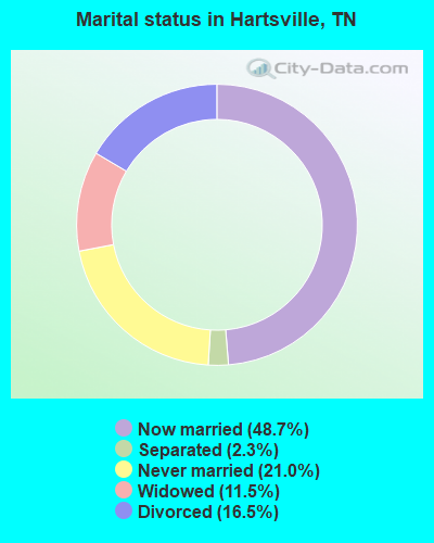
- Never married: 21.0%
- Now married: 48.7%
- Separated: 2.3%
- Widowed: 11.5%
- Divorced: 16.5%
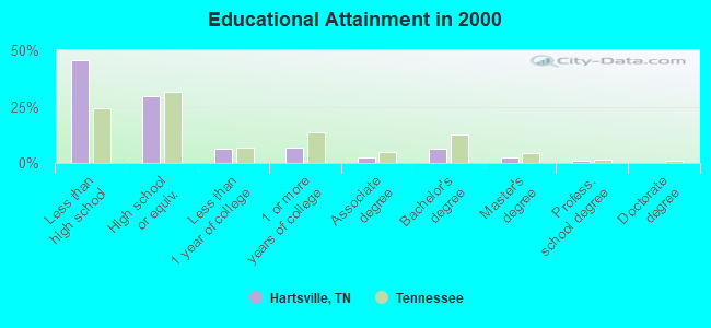
For population 25 years and over in Hartsville:
- High school or higher: 54.6%
- Bachelor's degree or higher: 9.7%
- Graduate or professional degree: 3.3%
- Unemployed: 7.9%
- Mean travel time to work (commute): 29.3 minutes
| Here: | 17.3 |
| Tennessee average: | 13.3 |
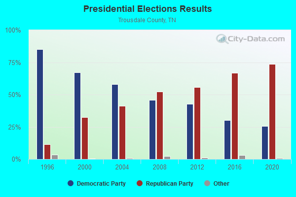
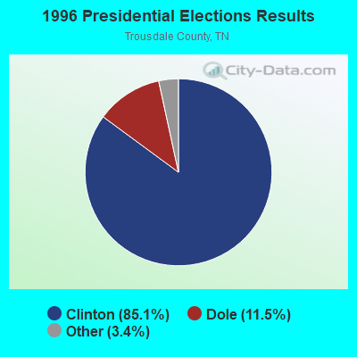
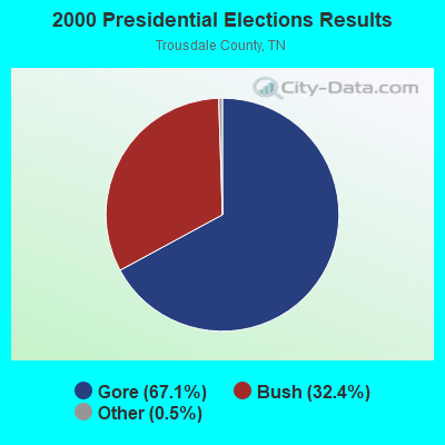
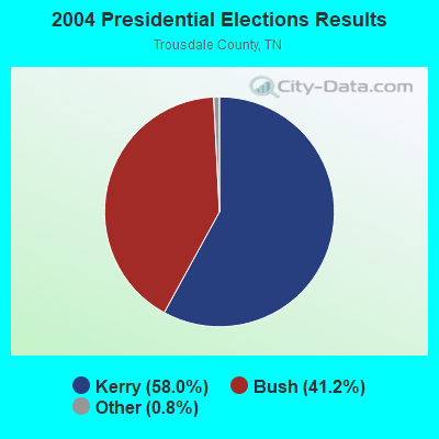
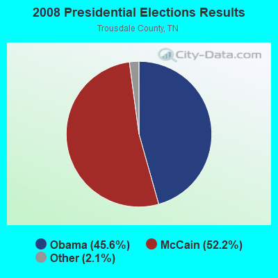
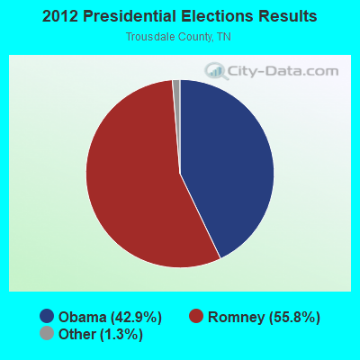
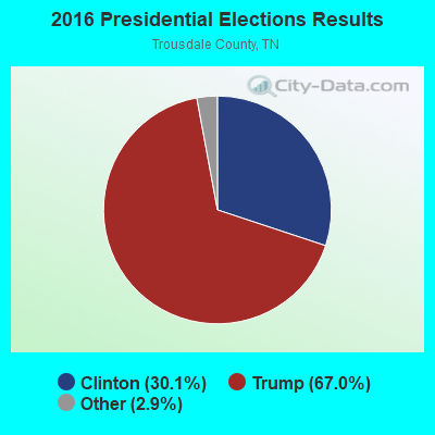
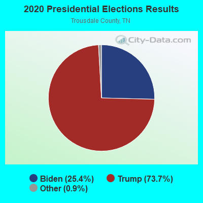
Graphs represent county-level data. Detailed 2008 Election Results
Religion statistics for Hartsville, TN (based on Trousdale County data)
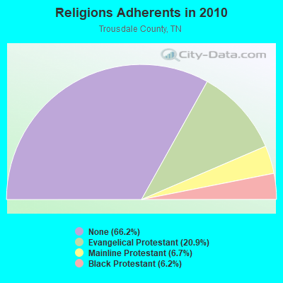
| Religion | Adherents | Congregations |
|---|---|---|
| Evangelical Protestant | 1,642 | 14 |
| Mainline Protestant | 529 | 4 |
| Black Protestant | 490 | 2 |
| Catholic | - | - |
| None | 5,209 | - |
Food Environment Statistics:
| This county: | 3.90 / 10,000 pop. |
| State: | 1.99 / 10,000 pop. |
| This county: | 7.79 / 10,000 pop. |
| State: | 5.16 / 10,000 pop. |
| This county: | 7.79 / 10,000 pop. |
| Tennessee: | 6.56 / 10,000 pop. |
| Trousdale County: | 12.1% |
| State: | 11.4% |
| Trousdale County: | 30.9% |
| Tennessee: | 30.2% |
| Trousdale County: | 7.5% |
| Tennessee: | 13.5% |
Hartsville government finances - Expenditure in 2002 (per resident):
- Construction - Elementary and Secondary Education: $115,000 ($45.53)
Regular Highways: $62,000 ($24.54)
- Current Operations - Elementary and Secondary Education: $5,965,000 ($2361.44)
Regular Highways: $1,203,000 ($476.25)
Police Protection: $767,000 ($303.64)
General - Other: $744,000 ($294.54)
Water Utilities: $689,000 ($272.76)
Solid Waste Management: $422,000 ($167.06)
Corrections - Other: $352,000 ($139.35)
Central Staff Services: $292,000 ($115.60)
Sewerage: $275,000 ($108.87)
Judicial and Legal Services: $225,000 ($89.07)
Health Services - Other: $192,000 ($76.01)
Financial Administration: $132,000 ($52.26)
General Public Buildings: $127,000 ($50.28)
Parks and Recreation: $78,000 ($30.88)
Libraries: $37,000 ($14.65)
Fire Protection: $27,000 ($10.69)
Protective Inspection and Regulation - Other: $6,000 ($2.38)
- General - Interest on Debt: $129,000 ($51.07)
- Intergovernmental to Local - Other - Elementary and Secondary Education: $0 ($0.00)
- Other Capital Outlay - Elementary and Secondary Education: $545,000 ($215.76)
Regular Highways: $57,000 ($22.57)
Judicial: $2,000 ($0.79)
- Total Salaries and Wages: $995,000 ($393.90)
- Water Utilities - Interest on Debt: $138,000 ($54.63)
Hartsville government finances - Revenue in 2002 (per resident):
- Charges - Other: $411,000 ($162.71)
Sewerage: $310,000 ($122.72)
Solid Waste Management: $181,000 ($71.65)
Elementary and Secondary Education - Other: $27,000 ($10.69)
Elementary and Secondary Education School Tuition: $1,000 ($0.40)
- Federal Intergovernmental - Other: $53,000 ($20.98)
- Local Intergovernmental - General Support: $534,000 ($211.40)
Other: $1,000 ($0.40)
- Miscellaneous - Interest Earnings: $255,000 ($100.95)
General Revenue - Other: $138,000 ($54.63)
Rents: $26,000 ($10.29)
- Revenue - Water Utilities: $975,000 ($385.99)
- State Intergovernmental - Education: $5,772,000 ($2285.04)
Highways: $1,232,000 ($487.73)
Other: $400,000 ($158.35)
General Support: $106,000 ($41.96)
Health and Hospitals: $2,000 ($0.79)
- Tax - Property: $2,978,000 ($1178.94)
Other: $124,000 ($49.09)
Alcoholic Beverage Sales: $105,000 ($41.57)
Motor Vehicle License: $45,000 ($17.81)
Public Utilities: $4,000 ($1.58)
Hartsville government finances - Debt in 2002 (per resident):
- Long Term Debt - Beginning Outstanding, Education - Other: $2,824,000 ($1117.97)
Outstanding - Full Faith and Credit - Elementary and Secondary Education: $2,536,000 ($1003.96)
Beginning Outstanding - Water Utilities: $1,975,000 ($781.87)
Outstanding - Full Faith and Credit - Water Utilities: $1,870,000 ($740.30)
Beginning Outstanding - Other: $1,168,000 ($462.39)
Outstanding - Full Faith and Credit - Other - Other: $805,000 ($318.69)
Retired Unspecified - Other - Other: $363,000 ($143.71)
Retired Unspecified - Elementary and Secondary Education: $288,000 ($114.01)
Retired Unspecified - Water Utilities: $105,000 ($41.57)
Hartsville government finances - Cash and Securities in 2002 (per resident):
- Other Funds - Cash and Deposits: $5,178,000 ($2049.88)
- Sinking Fund - Cash and Deposits: $368,000 ($145.68)
| Businesses in Hartsville, TN | ||||
| Name | Count | Name | Count | |
|---|---|---|---|---|
| H&R Block | 1 | SONIC Drive-In | 1 | |
| McDonald's | 1 | UPS | 1 | |
| Rite Aid | 1 | |||
Strongest AM radio stations in Hartsville:
- WTNK (1090 AM; 1 kW; HARTSVILLE, TN; Owner: G & L AIRCASTERS, INC.)
- WSM (650 AM; 50 kW; NASHVILLE, TN; Owner: GAYLORD ENTERTAINMENT COMPANY)
- WAMB (1160 AM; 50 kW; DONELSON, TN; Owner: GREAT SOUTHERN BROADCASTING COMPANY, INC.)
- WLAC (1510 AM; 50 kW; NASHVILLE, TN; Owner: CAPSTAR TX LIMITED PARTNERSHIP)
- WKDA (1200 AM; 50 kW; NASHVILLE, TN; Owner: RADIO NASHVILLE, INC.)
- WNQM (1300 AM; 50 kW; NASHVILLE, TN; Owner: WNQM. INC.)
- WHIN (1010 AM; 5 kW; GALLATIN, TN; Owner: WHIN, INC.)
- WPLN (1430 AM; 15 kW; MADISON, TN)
- WYXE (1130 AM; daytime; 2 kW; GALLATIN, TN; Owner: JON GARY ENTERPRISES, INC.)
- WWAM (820 AM; daytime; 50 kW; JASPER, TN; Owner: SHELTON BROADCASTING SYSTEM)
- WYFN (980 AM; 5 kW; NASHVILLE, TN; Owner: BIBLE BRADCASTING NETWORK, INC.)
- WCOR (900 AM; 5 kW; LEBANON, TN)
- WFLI (1070 AM; 50 kW; LOOKOUT MOUNTAIN, TN; Owner: WFLI, INC.)
Strongest FM radio stations in Hartsville:
- WMOT (89.5 FM; MURFREESBORO, TN; Owner: MIDDLE TENNESSEE STATE UNIVERSITY)
- WGFX (104.5 FM; GALLATIN, TN; Owner: CITADEL BROADCASTING COMPANY)
- WUCZ (104.1 FM; CARTHAGE, TN; Owner: WOOD BROADCASTING, INC.)
- WMAK (96.3 FM; MURFREESBORO, TN; Owner: SOUTH CENTRAL COMMUNICATIONS CORP.)
- WLCT (102.1 FM; LAFAYETTE, TN; Owner: LAFAYETTE BROADCASTING CO., INC.)
- WRVW (107.5 FM; LEBANON, TN; Owner: CAPSTAR TX LIMITED PARTNERSHIP)
- WANT (98.9 FM; LEBANON, TN; Owner: BAY-POINTE BROADCASTING, INC.)
- WVCP (88.5 FM; GALLATIN, TN; Owner: VOLUNTEER STATE COMMUNITY COLLEGE)
- WGGC (95.1 FM; GLASGOW, KY; Owner: HERITAGE COMMUNICATIONS, INC.)
- WSM-FM (95.5 FM; NASHVILLE, TN; Owner: CUMULUS LICENSING CORP.)
- W230AD (93.9 FM; GALLATIN, TN; Owner: TREVECCA NAZARENE UNIVERSITY, INC.)
- WFMQ (91.5 FM; LEBANON, TN; Owner: CUMBERLAND UNIVERSITY)
- WGSQ (94.7 FM; COOKEVILLE, TN; Owner: CLEAR CHANNEL BROADCASTING LICENSES, INC.)
- WKDF (103.3 FM; NASHVILLE, TN; Owner: CITADEL BROADCASTING COMPANY)
- WNRQ (105.9 FM; NASHVILLE, TN; Owner: CAPSTAR TX LIMITED PARTNERSHIP)
- WRLT (100.1 FM; FRANKLIN, TN; Owner: TUNED-IN BROADCASTING, INC)
- WSIX-FM (97.9 FM; NASHVILLE, TN; Owner: CAPSTAR TX LIMITED PARTNERSHIP)
- WPLN-FM (90.3 FM; NASHVILLE, TN; Owner: NASHVILLE PUBLIC RADIO)
- WNPL (106.7 FM; BELLE MEADE, TN; Owner: CUMULUS LICENSING CORP.)
- WAYM (88.7 FM; COLUMBIA, TN; Owner: WAY-FM MEDIA GROUP, INC.)
TV broadcast stations around Hartsville:
- WPGD (Channel 50; HENDERSONVILLE, TN; Owner: TRINITY BROADCASTING NETWORK)
- WTVF (Channel 5; NASHVILLE, TN; Owner: NEWSCHANNEL 5 NETWORK, LP)
- WHTN (Channel 39; MURFREESBORO, TN; Owner: CHRISTIAN TELEVISION NETWORK, INC.)
- WNPX (Channel 28; COOKEVILLE, TN; Owner: PAXSON COMMUNICATIONS LICENSE COMPANY, LLC)
- WUXP-TV (Channel 30; NASHVILLE, TN; Owner: WUXP LICENSEE, LLC)
- WSMV-TV (Channel 4; NASHVILLE, TN; Owner: MEREDITH CORPORATION)
- WZTV (Channel 17; NASHVILLE, TN; Owner: WZTV LICENSEE, LLC)
- WNAB (Channel 58; NASHVILLE, TN; Owner: NASHVILLE LICENSE HOLDINGS, L.L.C.)
- WNPX-LP (Channel 20; NASHVILLE, TN; Owner: PAXSON COMMUNICATIONS LPTV, INC.)
- WJFB (Channel 66; LEBANON, TN; Owner: BRYANT BROADCASTING, INC.)
- National Bridge Inventory (NBI) Statistics
- 14Number of bridges
- 194ft / 58.7mTotal length
- $20,724,000Total costs
- 59,520Total average daily traffic
- 3,827Total average daily truck traffic
- 95,688Total future (year 2041) average daily traffic
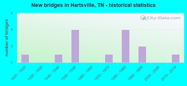
- New bridges - historical statistics
- 11920-1929
- 11940-1949
- 41950-1959
- 11970-1979
- 41980-1989
- 21990-1999
- 12010-2019
FCC Registered Cell Phone Towers:
2 (See the full list of FCC Registered Cell Phone Towers in Hartsville)FCC Registered Antenna Towers:
38 (See the full list of FCC Registered Antenna Towers)FCC Registered Private Land Mobile Towers:
1 (See the full list of FCC Registered Private Land Mobile Towers in Hartsville, TN)FCC Registered Broadcast Land Mobile Towers:
9 (See the full list of FCC Registered Broadcast Land Mobile Towers)FCC Registered Microwave Towers:
3- HARTSVILLE, 136 Morrison Street (Lat: 36.389250 Lon: -86.173389), Type: Gtower, Structure height: 54.9 m, Overall height: 60.7 m, Call Sign: WQUB483,
Assigned Frequencies: 5945.20 MHz, Grant Date: 05/28/2014, Expiration Date: 05/28/2024, Certifier: Douglas W Chambers, Registrant: Wilkinson Barker Knauer, LLP, 1800 M Street Nw, Suite 800n, Washington, DC 20036, Phone: (202) 383-3420, Fax: (202) 783-5851, Email:
- BARTHELIA, Watson Lane (Lat: 36.366444 Lon: -86.235056), Type: Ltower, Structure height: 76.2 m, Overall height: 79.2 m, Call Sign: WRAX252,
Assigned Frequencies: 10815.0 MHz, 10815.0 MHz, 10815.0 MHz, 10895.0 MHz, 10895.0 MHz, 10895.0 MHz, Grant Date: 03/30/2018, Expiration Date: 03/30/2028, Cancellation Date: 08/09/2023, Certifier: Gregory M Romano, Registrant: Cellco Partnership, 5055 Northpointe Pkwy, Alpharetta, GA 30022, Phone: (770) 797-1070, Email:
- MORRISON STREET, 238 Morrison Street (Lat: 36.389250 Lon: -86.173389), Type: Ltower, Structure height: 54.9 m, Overall height: 57.9 m, Call Sign: WREP726,
Assigned Frequencies: 11325.0 MHz, 11325.0 MHz, 11325.0 MHz, 11325.0 MHz, 11325.0 MHz, 11325.0 MHz, Grant Date: 11/21/2019, Expiration Date: 11/21/2029, Certifier: Wayland Cothron, Registrant: Communications Group Inc, 441 Donelson Pike, Suite #420, Nashville, TN 37214, Phone: (615) 889-4756, Fax: (615) 391-0300, Email:
FCC Registered Amateur Radio Licenses:
34 (See the full list of FCC Registered Amateur Radio Licenses in Hartsville)FAA Registered Aircraft:
2- Aircraft: SCIUK PHIL RENEGADE WARRIOR (Category: Land, Seats: 2, Weight: Up to 12,499 Pounds), Engine: Reciprocating
N-Number: 593R, N593R, N-593R, Serial Number: PS-173, Certificate Issue Date: 01/24/2019
Registrant (Individual): Richard E Thomas, 978 Drury Ridge Rd, Hartsville, TN 37074 - Aircraft: PIPER PA-28-140 (Category: Land, Seats: 4, Weight: Up to 12,499 Pounds, Speed: 107 mph), Engine: LYCOMING 0-320 SERIES (180 HP) (Reciprocating)
N-Number: 5LG, N5LG, N-5LG, Serial Number: 28-22238, Year manufactured: 1966, Airworthiness Date: 10/22/1966, Certificate Issue Date: 07/30/2020
Registrant (Corporation): Turning Point @ Sonrise Inc, 1085 Old Hwy 25, Hartsville, TN 37074
2002 - 2018 National Fire Incident Reporting System (NFIRS) incidents
- Fire incident types reported to NFIRS in Hartsville, TN
- 23848.4%Structure Fires
- 16733.9%Outside Fires
- 8216.7%Mobile Property/Vehicle Fires
- 51.0%Other
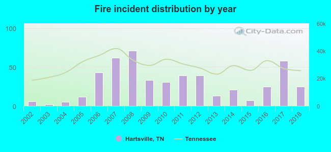 According to the data from the years 2002 - 2018 the average number of fire incidents per year is 29. The highest number of reported fire incidents - 71 took place in 2008, and the least - 2 in 2003. The data has a rising trend.
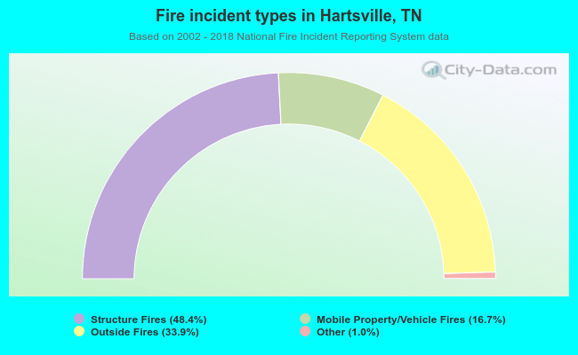 When looking into fire subcategories, the most incidents belonged to: Structure Fires (48.4%), and Outside Fires (33.9%).
| Most common first names in Hartsville, TN among deceased individuals | ||
| Name | Count | Lived (average) |
|---|---|---|
| William | 66 | 74.4 years |
| James | 62 | 72.9 years |
| Mary | 56 | 78.5 years |
| John | 44 | 76.7 years |
| Robert | 32 | 67.6 years |
| Willie | 31 | 77.7 years |
| George | 23 | 69.0 years |
| Annie | 22 | 80.7 years |
| Ruby | 18 | 79.6 years |
| Henry | 18 | 77.0 years |
| Most common last names in Hartsville, TN among deceased individuals | ||
| Last name | Count | Lived (average) |
|---|---|---|
| Gregory | 72 | 76.1 years |
| Satterfield | 31 | 70.3 years |
| Oldham | 27 | 79.8 years |
| Williams | 25 | 74.1 years |
| Presley | 23 | 66.0 years |
| Harper | 22 | 77.5 years |
| Jones | 22 | 76.7 years |
| Cothron | 22 | 79.8 years |
| Dalton | 21 | 79.1 years |
| Scruggs | 21 | 74.2 years |
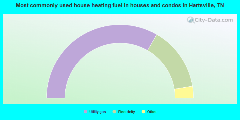
- 66.7%Utility gas
- 28.1%Electricity
- 3.6%Bottled, tank, or LP gas
- 1.6%Fuel oil, kerosene, etc.
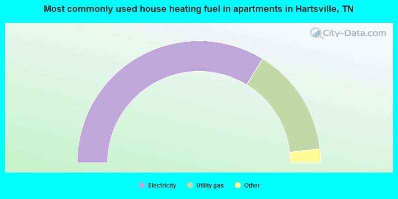
- 67.4%Electricity
- 28.9%Utility gas
- 2.1%Fuel oil, kerosene, etc.
- 1.6%No fuel used
Hartsville compared to Tennessee state average:
- Unemployed percentage below state average.
- Hispanic race population percentage significantly below state average.
- Foreign-born population percentage significantly below state average.
- Renting percentage significantly below state average.
- Length of stay since moving in significantly above state average.
- Number of rooms per house significantly below state average.
- House age significantly below state average.
- Institutionalized population percentage significantly above state average.
- Number of college students below state average.
- Percentage of population with a bachelor's degree or higher below state average.

|
Total of 1 patent application in 2008-2024.