Harmony, New York
Harmony: Chautauqua County , Harmony NY, Will not comply with DEC orders to Clean Up Uncontained Landfill (Web Page Coming Soon Email Me for details)
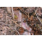
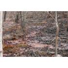
Harmony: Little Brokenstraw Creek N Harmony Chautauqua County NY A Rainbow Of Colors
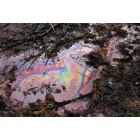
Harmony: The Creek That Runs Through N Harmony Land To Our Land SO Colorful
- add
your
Submit your own pictures of this town and show them to the world
- OSM Map
- Google Map
- MSN Map
Population change since 2000: -5.7%
 |
| Males: 1,088 | |
| Females: 1,118 |
| Median resident age: | 43.4 years |
| New York median age: | 40.7 years |
Zip codes: 14710.
| Harmony: | $53,998 |
| NY: | $79,557 |
Estimated per capita income in 2022: $29,181 (it was $15,292 in 2000)
Harmony town income, earnings, and wages data
Estimated median house or condo value in 2022: $110,191 (it was $56,400 in 2000)
| Harmony: | $110,191 |
| NY: | $400,400 |
Mean prices in 2022: all housing units: $168,876; detached houses: $173,869; townhouses or other attached units: $92,544; in 2-unit structures: $200,826; in 3-to-4-unit structures: $86,545; in 5-or-more-unit structures: $466,469; mobile homes: $70,313
Detailed information about poverty and poor residents in Harmony, NY
Compare current foreclosures near Harmony, NY:
| Photo | Address | Area | Beds / Baths | Price | Details |
|---|---|---|---|---|---|

|
#1
Prendergast Ave
Jamestown, NY 14701
|
3,064 sq. feet
|
3 baths 5 beds |
$42,500
|
show details |

|
#2
Mead Ave
Corry, PA 16407
|
1,272 sq. feet
|
2 baths 3 beds |
$19,900
|
show details |

|
#3
Euclid Ave
Jamestown, NY 14701
|
2,290 sq. feet
|
2 baths 5 beds |
show details | |

|
#4
E Chautauqua St
Mayville, NY 14757
|
2,012 sq. feet
|
2 baths 4 beds |
show details | |

|
#5
Prendergast Ave
Jamestown, NY 14701
|
2 sq. feet
|
2 baths 3 beds |
show details | |

|
#6
Wilson St
Gerry, NY 14740
|
- sq. feet
|
1 baths 5 beds |
show details | |

|
#7
Valleyview Ave
Jamestown, NY 14701
|
1,490 sq. feet
|
1 baths 3 beds |
show details | |

|
#8
Terrace Dr
Gerry, NY 14740
|
1,740 sq. feet
|
1 baths 3 beds |
show details | |

|
#9
Buffalo St
Jamestown, NY 14701
|
1,728 sq. feet
|
2 baths 4 beds |
show details | |

|
#10
Howard St
Jamestown, NY 14701
|
1,512 sq. feet
|
1 baths 2 beds |
show details |
| Photo | Address | Area | Beds / Baths | Price | Details |
|---|---|---|---|---|---|

|
#11
W Smith St
Corry, PA 16407
|
1,362 sq. feet
|
1 baths 4 beds |
show details | |

|
#12
Elm St
Jamestown, NY 14701
|
1,881 sq. feet
|
2 baths 4 beds |
show details | |

|
#13
Van Buren St
Jamestown, NY 14701
|
1,672 sq. feet
|
1 baths 3 beds |
show details | |

|
#14
W Smith St
Corry, PA 16407
|
1,394 sq. feet
|
1 baths 3 beds |
show details | |

|
#15
Bowen St
Jamestown, NY 14701
|
1,663 sq. feet
|
1 baths 3 beds |
show details | |

|
#16
Baker St
Lakewood, NY 14750
|
2,198 sq. feet
|
2 baths 3 beds |
show details | |

|
#17
E Virginia Blvd
Jamestown, NY 14701
|
750 sq. feet
|
1 baths 3 beds |
show details | |

|
#18
Harris Ave
Jamestown, NY 14701
|
1,500 sq. feet
|
1 baths 3 beds |
show details | |

|
#19
Wayne St
Corry, PA 16407
|
1,156 sq. feet
|
1 baths 2 beds |
show details | |

|
#20
Worth St
Corry, PA 16407
|
1,200 sq. feet
|
1 baths 3 beds |
show details |
| Photo | Address | Area | Beds / Baths | Price | Details |
|---|---|---|---|---|---|

|
#21
Mead Ave
Corry, PA 16407
|
2,358 sq. feet
|
1 baths 3 beds |
show details | |

|
#22
W Bond St
Corry, PA 16407
|
1,129 sq. feet
|
1 baths 2 beds |
show details | |

|
#23
Broadhead Ave
Jamestown, NY 14701
|
1,761 sq. feet
|
1 baths 3 beds |
show details | |

|
#24
Charles St
Jamestown, NY 14701
|
1,328 sq. feet
|
1 baths 3 beds |
show details | |

|
#25
Brook St
Corry, PA 16407
|
1,324 sq. feet
|
1 baths 3 beds |
show details | |

|
#26
S Chicago Ave
Jamestown, NY 14701
|
1,350 sq. feet
|
1 baths 3 beds |
show details | |

|
#27
Bunce Rd
Frewsburg, NY 14738
|
1,500 sq. feet
|
1 baths 2 beds |
show details | |

|
#28
Cowing Rd
Lakewood, NY 14750
|
1,232 sq. feet
|
1 baths 2 beds |
show details | |

|
#29
Wiltsie Rd
Frewsburg, NY 14738
|
1,346 sq. feet
|
1 baths 3 beds |
show details | |

|
#30
Briarwood Dr
Lakewood, NY 14750
|
3,356 sq. feet
|
5 baths 4 beds |
show details |
| Photo | Address | Area | Beds / Baths | Price | Details |
|---|---|---|---|---|---|

|
#31
E 3rd St
Lakewood, NY 14750
|
1,816 sq. feet
|
1 baths 3 beds |
show details | |

|
#32
Thom Run Ln
Spring Creek, PA 16436
|
- sq. feet
|
2 baths 3 beds |
show details | |

|
#33
Water St
Frewsburg, NY 14738
|
1,248 sq. feet
|
2 baths 2 beds |
show details | |

|
#34
Hazeltine Ave
Jamestown, NY 14701
|
2,096 sq. feet
|
1 baths 3 beds |
show details | |

|
#35
Harding Ave
Jamestown, NY 14701
|
1,749 sq. feet
|
1 baths 3 beds |
show details | |

|
#36
Grand St
Corry, PA 16407
|
1,242 sq. feet
|
1 baths 3 beds |
show details | |

|
#37
Palmer St
Jamestown, NY 14701
|
1,280 sq. feet
|
1 baths 1 beds |
show details | |

|
#38
Meadow Ln
Jamestown, NY 14701
|
2,537 sq. feet
|
2 baths 5 beds |
show details | |

|
#39
Hess St
Jamestown, NY 14701
|
1,255 sq. feet
|
1 baths 3 beds |
show details | |

|
#40
Utica St
Jamestown, NY 14701
|
1,237 sq. feet
|
1 baths 3 beds |
show details |
| Photo | Address | Area | Beds / Baths | Price | Details |
|---|---|---|---|---|---|

|
#41
Baker St
Jamestown, NY 14701
|
1,724 sq. feet
|
1 baths 3 beds |
show details | |

|
#42
Arden Pkwy
Jamestown, NY 14701
|
1,924 sq. feet
|
1 baths 3 beds |
show details | |

|
#43
Hall Ave
Jamestown, NY 14701
|
1,424 sq. feet
|
1 baths 3 beds |
show details | |

|
#44
Superior St
Jamestown, NY 14701
|
1,600 sq. feet
|
1 baths 3 beds |
show details | |

|
#45
Mead Ave
Corry, PA 16407
|
2,906 sq. feet
|
1 baths 2 beds |
show details | |

|
#46
W Smith St
Corry, PA 16407
|
- sq. feet
|
- baths - beds |
show details | |

|
#47
Centennial St
Frewsburg, NY 14738
|
- sq. feet
|
- baths - beds |
show details | |

|
#48
Lindsey Hollow Rd
Corry, PA 16407
|
- sq. feet
|
- baths - beds |
show details | |

|
#49
Concord St
Corry, PA 16407
|
- sq. feet
|
- baths - beds |
show details | |

|
Check over 1 million property listings on Foreclosure.com!
|
browse all offers | |||

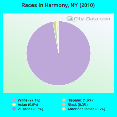
- 2,14397.1%White alone
- 351.6%Hispanic
- 100.5%Asian alone
- 60.3%Black alone
- 60.3%Two or more races
- 50.2%American Indian alone
- 10.05%Native Hawaiian and Other
Pacific Islander alone
Races in Harmony detailed stats: ancestries, foreign born residents, place of birth
 Recent articles from our blog. Our writers, many of them Ph.D. graduates or candidates, create easy-to-read articles on a wide variety of topics.
Ancestries: English (18.4%), German (17.2%), Swedish (14.3%), Irish (13.0%), Italian (6.6%), Dutch (5.6%).
Current Local Time: EST time zone
Land area: 45.5 square miles.
Population density: 48 people per square mile (very low).
7 residents are foreign born
| This town: | 0.3% |
| New York: | 20.4% |
| Harmony town: | 2.0% ($1,141) |
| New York: | 1.9% ($2,847) |
Nearest city with pop. 50,000+: Erie, PA  (32.8 miles , pop. 103,717).
Nearest city with pop. 200,000+: Buffalo, NY (65.9 miles , pop. 292,648).
Nearest city with pop. 1,000,000+: Philadelphia, PA (265.6 miles , pop. 1,517,550).
Nearest cities:
), Latitude: 42.06 N, Longitude: 79.44 W
Area code commonly used in this area: 716
Single-family new house construction building permits:
- 2012: 1 building, cost: $136,000
- 2011: 1 building, cost: $136,000
- 2010: 1 building, cost: $136,000
- 2009: 3 buildings, average cost: $91,700
- 2008: 3 buildings, average cost: $91,700
- 2007: 3 buildings, average cost: $87,300
- 2006: 4 buildings, average cost: $87,300
- 2005: 5 buildings, average cost: $87,300
- 2004: 6 buildings, average cost: $87,300
- 2003: 3 buildings, average cost: $155,000
- 2002: 7 buildings, average cost: $64,700
- 2001: 2 buildings, average cost: $55,000
- 2000: 2 buildings, average cost: $55,000
- 1999: 4 buildings, average cost: $51,300
- 1998: 4 buildings, average cost: $51,300
- 1997: 4 buildings, average cost: $51,300
| Here: | 4.8% |
| New York: | 4.4% |
- Educational services (11.3%)
- Health care (10.0%)
- Metal & metal products (8.4%)
- Construction (7.6%)
- Accommodation & food services (5.1%)
- Finance & insurance (4.0%)
- Machinery (3.7%)
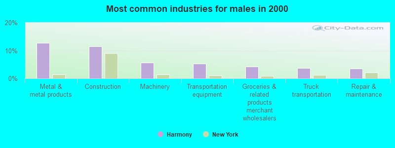
- Metal & metal products (12.8%)
- Construction (11.6%)
- Machinery (5.6%)
- Transportation equipment (5.3%)
- Groceries & related products merchant wholesalers (4.3%)
- Truck transportation (3.7%)
- Repair & maintenance (3.6%)
- Educational services (22.1%)
- Health care (21.2%)
- Accommodation & food services (7.4%)
- Finance & insurance (6.8%)
- Social assistance (5.4%)
- Department & other general merchandise stores (3.8%)
- Personal & laundry services (3.6%)
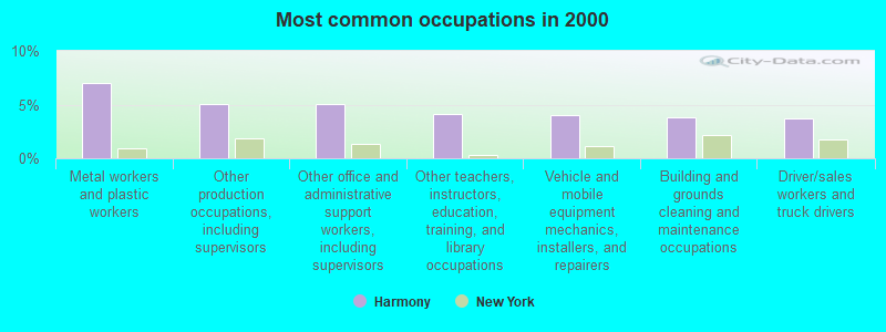
- Metal workers and plastic workers (7.0%)
- Other production occupations, including supervisors (5.0%)
- Other office and administrative support workers, including supervisors (5.0%)
- Other teachers, instructors, education, training, and library occupations (4.1%)
- Vehicle and mobile equipment mechanics, installers, and repairers (4.0%)
- Building and grounds cleaning and maintenance occupations (3.8%)
- Driver/sales workers and truck drivers (3.7%)
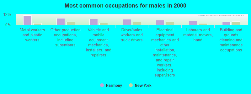
- Metal workers and plastic workers (10.7%)
- Other production occupations, including supervisors (7.5%)
- Vehicle and mobile equipment mechanics, installers, and repairers (7.0%)
- Driver/sales workers and truck drivers (6.5%)
- Electrical equipment mechanics and other installation, maintenance, and repair workers, including supervisors (5.3%)
- Laborers and material movers, hand (4.3%)
- Building and grounds cleaning and maintenance occupations (3.7%)
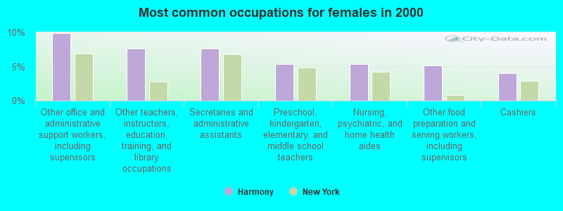
- Other office and administrative support workers, including supervisors (9.9%)
- Other teachers, instructors, education, training, and library occupations (7.7%)
- Secretaries and administrative assistants (7.7%)
- Preschool, kindergarten, elementary, and middle school teachers (5.4%)
- Nursing, psychiatric, and home health aides (5.4%)
- Other food preparation and serving workers, including supervisors (5.2%)
- Cashiers (4.1%)
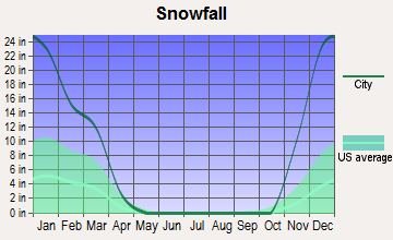
Average climate in Harmony, New York
Based on data reported by over 4,000 weather stations


(lower is better)
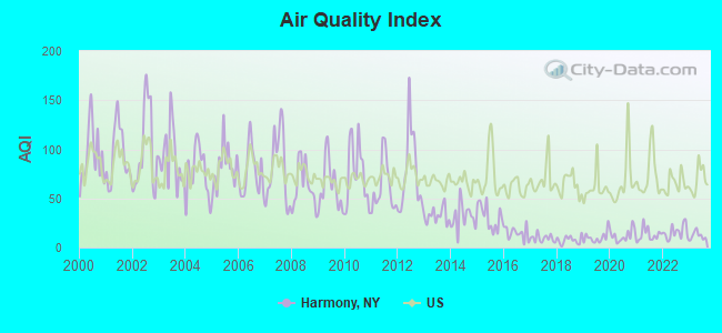
Air Quality Index (AQI) level in 2023 was 12.3. This is significantly better than average.
| City: | 12.3 |
| U.S.: | 72.6 |
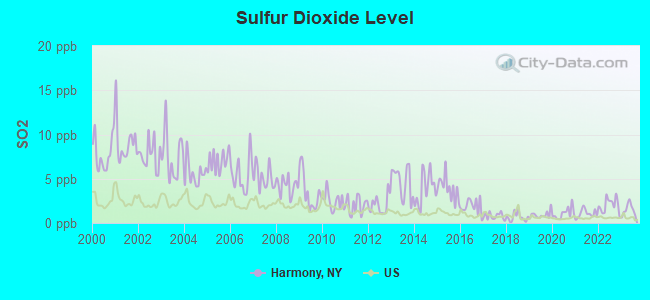
Sulfur Dioxide (SO2) [ppb] level in 2023 was 1.53. This is about average. Closest monitor was 10.4 miles away from the city center.
| City: | 1.53 |
| U.S.: | 1.51 |
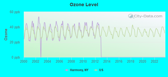
Ozone [ppb] level in 2012 was 36.2. This is about average. Closest monitor was 15.9 miles away from the city center.
| City: | 36.2 |
| U.S.: | 33.3 |
Tornado activity:
Harmony-area historical tornado activity is above New York state average. It is 36% smaller than the overall U.S. average.
On 5/31/1985, a category F4 (max. wind speeds 207-260 mph) tornado 0.8 miles away from the Harmony town center .
On 6/20/1969, a category F3 (max. wind speeds 158-206 mph) tornado 10.0 miles away from the town center caused between $500,000 and $5,000,000 in damages.
Earthquake activity:
Harmony-area historical earthquake activity is significantly above New York state average. It is 64% smaller than the overall U.S. average.On 9/25/1998 at 19:52:52, a magnitude 5.2 (4.8 MB, 4.3 MS, 5.2 LG, 4.5 MW, Depth: 3.1 mi, Class: Moderate, Intensity: VI - VII) earthquake occurred 63.0 miles away from Harmony center
On 1/31/1986 at 16:46:43, a magnitude 5.0 (5.0 MB) earthquake occurred 94.0 miles away from the city center
On 8/23/2011 at 17:51:04, a magnitude 5.8 (5.8 MW, Depth: 3.7 mi) earthquake occurred 297.8 miles away from Harmony center
On 10/7/1983 at 10:18:46, a magnitude 5.3 (5.1 MB, 5.3 LG, 5.1 ML) earthquake occurred 289.3 miles away from Harmony center
On 4/20/2002 at 10:50:47, a magnitude 5.3 (5.3 ML, Depth: 3.0 mi) earthquake occurred 335.2 miles away from Harmony center
On 1/26/2001 at 03:03:20, a magnitude 3.9 (3.9 MB, Depth: 3.1 mi, Class: Light, Intensity: II - III) earthquake occurred 70.4 miles away from the city center
Magnitude types: regional Lg-wave magnitude (LG), body-wave magnitude (MB), local magnitude (ML), surface-wave magnitude (MS), moment magnitude (MW)
Natural disasters:
The number of natural disasters in Chautauqua County (21) is greater than the US average (15).Major Disasters (Presidential) Declared: 11
Emergencies Declared: 9
Causes of natural disasters: Floods: 9, Storms: 9, Snowstorms: 4, Hurricanes: 2, Winter Storms: 2, Blizzard: 1, Ice Storm: 1, Power Outage: 1, Snow: 1, Tropical Storm: 1, Wind: 1, Other: 2 (Note: some incidents may be assigned to more than one category).
Hospitals and medical centers near Harmony:
- MANOR OAK SKILLED NURSING FACILITIES JAMESTOWN (Nursing Home, about 10 miles away; JAMESTOWN, NY)
- JAMESTOWN GENERAL HOSPITAL (Hospital, about 11 miles away; JAMESTOWN, NY)
- HERITAGE PARK HEALTH CARE CENTER (Nursing Home, about 11 miles away; JAMESTOWN, NY)
- HOSPICE CHAUTAUQUA COUNTY INC (Hospital, about 11 miles away; MAYVILLE, NY)
- WOMENS CHRISTIAN ASSOC. HOSP. (Dialysis Facility, about 11 miles away; JAMESTOWN, NY)
- WOMAN'S CHRISTIAN ASSOCIATION Acute Care Hospitals (about 11 miles away; JAMESTOWN, NY)
- CHAUTAUQUA COUNTY CHAPTER NYS ARC, INC (Hospital, about 12 miles away; JAMESTOWN, NY)
Colleges/universities with over 2000 students nearest to Harmony:
- Jamestown Community College (about 13 miles; Jamestown, NY; Full-time enrollment: 3,384)
- SUNY at Fredonia (about 28 miles; Fredonia, NY; FT enrollment: 5,523)
- Pennsylvania State University-Penn State Erie-Behrend College (about 29 miles; Erie, PA; FT enrollment: 4,025)
- Mercyhurst University (about 32 miles; Erie, PA; FT enrollment: 2,888)
- Gannon University (about 34 miles; Erie, PA; FT enrollment: 3,760)
- Edinboro University of Pennsylvania (about 38 miles; Edinboro, PA; FT enrollment: 6,746)
- Allegheny College (about 47 miles; Meadville, PA; FT enrollment: 2,249)
Points of interest:
Notable locations in Harmony: King Corners (A), Odell Farms (B), Panama Fire Department (C). Display/hide their locations on the map
Churches in Harmony include: Niobe Baptist Church (A), Our Lady of the Snows (B), Panama Baptist Church (C), Panama United Methodist Church (D). Display/hide their locations on the map
Cemeteries: Blockville Union Burying Ground (1), Tillotson Cemetery (2), Grant Cemetery (3), Panama Union Cemetery (4), Greenwood Cemetery (5), Town Line Cemetery (6). Display/hide their locations on the map
Creek: East Branch Little Brokenstraw Creek (A). Display/hide its location on the map
| This town: | 2.6 people |
| New York: | 2.6 people |
| This town: | 74.1% |
| Whole state: | 63.5% |
| This town: | 7.5% |
| Whole state: | 6.8% |
Likely homosexual households (counted as self-reported same-sex unmarried-partner households)
- Lesbian couples: 0.8% of all households
- Gay men: 0.0% of all households
| This town: | 10.6% |
| Whole state: | 14.6% |
| This town: | 5.4% |
| Whole state: | 7.4% |
For population 15 years and over in Harmony:
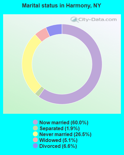
- Never married: 26.5%
- Now married: 60.0%
- Separated: 1.9%
- Widowed: 5.1%
- Divorced: 6.6%
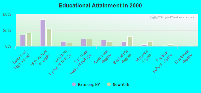
For population 25 years and over in Harmony:
- High school or higher: 81.8%
- Bachelor's degree or higher: 10.8%
- Graduate or professional degree: 3.5%
- Unemployed: 5.8%
- Mean travel time to work (commute): 23.6 minutes
| Here: | 8.8 |
| New York average: | 14.2 |
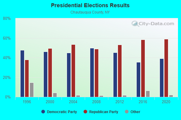
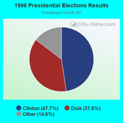
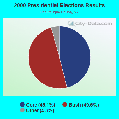
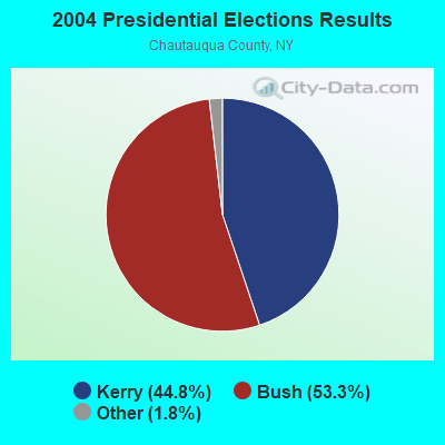
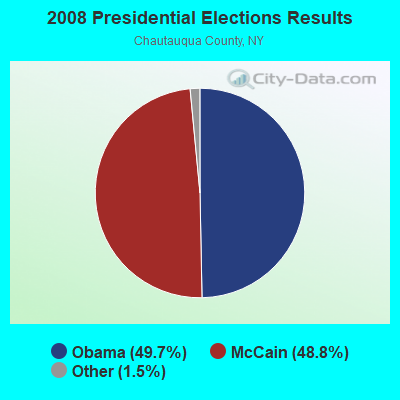
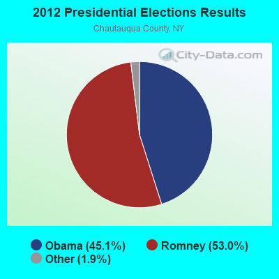
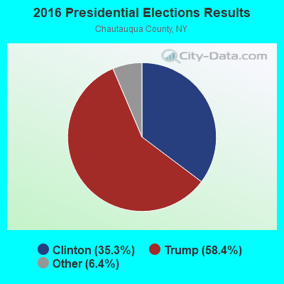
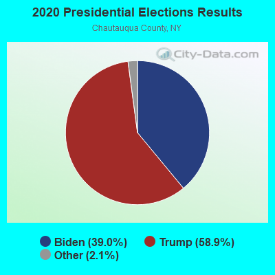
Graphs represent county-level data. Detailed 2008 Election Results
Religion statistics for Harmony, NY (based on Chautauqua County data)
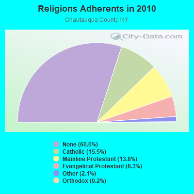
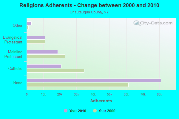
| Religion | Adherents | Congregations |
|---|---|---|
| Catholic | 20,912 | 13 |
| Mainline Protestant | 18,659 | 86 |
| Evangelical Protestant | 11,175 | 105 |
| Other | 2,884 | 19 |
| Orthodox | 230 | 2 |
| Black Protestant | 120 | 1 |
| None | 80,925 | - |
Food Environment Statistics:
| This county: | 2.76 / 10,000 pop. |
| State: | 4.13 / 10,000 pop. |
| Here: | 0.07 / 10,000 pop. |
| New York: | 0.06 / 10,000 pop. |
| Chautauqua County: | 1.12 / 10,000 pop. |
| State: | 0.92 / 10,000 pop. |
| This county: | 3.06 / 10,000 pop. |
| State: | 1.68 / 10,000 pop. |
| Chautauqua County: | 11.05 / 10,000 pop. |
| New York: | 8.82 / 10,000 pop. |
| Here: | 8.1% |
| New York: | 8.2% |
| Here: | 29.3% |
| State: | 23.8% |
| This county: | 12.4% |
| New York: | 15.6% |
Strongest AM radio stations in Harmony:
- WWKB (1520 AM; 50 kW; BUFFALO, NY; Owner: ENTERCOM BUFFALO LICENSE, LLC)
- WJTN (1240 AM; 1 kW; JAMESTOWN, NY; Owner: MEDIA ONE GROUP, LLC)
- WNAE (1310 AM; 5 kW; WARREN, PA; Owner: KINZUA BROADCASTING COMPANY)
- WKSN (1340 AM; 1 kW; JAMESTOWN, NY; Owner: VOX ALLEGANY, L.L.C.)
- KDKA (1020 AM; 50 kW; PITTSBURGH, PA; Owner: INFINITY BROADCASTING OPERATIONS, INC.)
- WRIE (1260 AM; 5 kW; ERIE, PA; Owner: REGENT LICENSEE OF ERIE, INC.)
- WFNN (1330 AM; 5 kW; ERIE, PA; Owner: NM LICENSING, LLC)
- WWCB (1370 AM; 1 kW; CORRY, PA; Owner: CORRY COMMUNICATIONS CORPORATION)
- WKNR (850 AM; 50 kW; CLEVELAND, OH; Owner: CARON BROADCASTING, INC.)
- WHAM (1180 AM; 50 kW; ROCHESTER, NY; Owner: CITICASTERS LICENSES, L.P.)
- WTAM (1100 AM; 50 kW; CLEVELAND, OH; Owner: JACOR BROADCASTING CORPORATION)
- WHK (1220 AM; 50 kW; CLEVELAND, OH; Owner: CARON BROADCASTING, INC.)
- WGR (550 AM; 5 kW; BUFFALO, NY; Owner: ENTERCOM BUFFALO LICENSE, LLC)
Strongest FM radio stations in Harmony:
- WWSE (93.3 FM; JAMESTOWN, NY; Owner: MEDIA ONE GROUP, LLC)
- WKZA (106.9 FM; LAKEWOOD, NY; Owner: CROSS COUNTRY COMMUNICATIONS, LLC)
- WUBJ (88.1 FM; JAMESTOWN, NY; Owner: STATE UNIVERSITY OF NEW YORK)
- W205BA (88.9 FM; JAMESTOWN, NY; Owner: BIBLE BROADCASTING NETWORK, INC.)
- WNJA (89.7 FM; JAMESTOWN, NY; Owner: WESTERN NEW YORK PUBLIC B/CING ASSOC)
- WCOT (90.9 FM; JAMESTOWN, NY; Owner: FAMILY LIFE MINISTRIES, INC.)
- WQFX-FM (103.1 FM; RUSSELL, PA; Owner: SOUTHBRIDGE RADIO CORPORATION)
- WRKT (100.9 FM; NORTH EAST, PA; Owner: NM LICENSING, LLC)
- WBKX (96.5 FM; FREDONIA, NY; Owner: CHADWICK BAY BROADCASTING CORPORATION)
- WMHU (101.9 FM; JAMESTOWN, NY; Owner: VOX ALLEGANY, L.L.C.)
- WRRN (92.3 FM; WARREN, PA; Owner: KINZUA BROADCASTING COMPANY, INC.)
- WRTS (103.7 FM; ERIE, PA; Owner: NM LICENSING, LLC)
- WMCE (88.5 FM; ERIE, PA; Owner: MERCYHURST COLLEGE)
- WXKC (99.9 FM; ERIE, PA; Owner: REGENT LICENSEE OF ERIE, INC.)
- WKNB (104.3 FM; CLARENDON, PA; Owner: KINZUA BROADCASTING CO., INC)
- WFGO (94.7 FM; ERIE, PA; Owner: NM LICENSING, LLC)
- WQHZ (102.3 FM; ERIE, PA; Owner: REGENT LICENSEE OF ERIE, INC.)
- WCTL (106.3 FM; UNION CITY, PA; Owner: INSPIRATION TIME, INC.)
TV broadcast stations around Harmony:
- W46BA (Channel 46; JAMESTOWN, NY; Owner: WESTERN NEW YORK PUBLIC B/CING.ASSN.)
- WNYB (Channel 26; JAMESTOWN, NY; Owner: FAITH BROADCASTING NETWORK, INC.)
- WICU-TV (Channel 12; ERIE, PA; Owner: SJL OF PENNSYLVANIA, INC.)
- WJET-TV (Channel 24; ERIE, PA; Owner: NEXSTAR BROADCASTING OF ERIE, L.L.C.)
- WSEE-TV (Channel 35; ERIE, PA; Owner: INITIAL BROADCASTING OF PENNSYLVANIA LICENSE SUBSIDIARY, LLC)
- WQLN (Channel 54; ERIE, PA; Owner: PUBLIC B/C OF NW PENN. INC.)
- WFXP (Channel 66; ERIE, PA; Owner: MISSION BROADCASTING, INC.)
- W10BH (Channel 10; JAMESTOWN, NY; Owner: TRINITY BROADCASTING NETWORK)
- National Bridge Inventory (NBI) Statistics
- 13Number of bridges
- 59ft / 18.1mTotal length
- $13,417,000Total costs
- 7,067Total average daily traffic
- 588Total average daily truck traffic
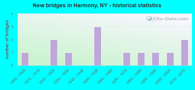
- New bridges - historical statistics
- 11900-1909
- 21920-1929
- 11930-1939
- 31950-1959
- 11970-1979
- 11980-1989
- 11990-1999
- 12000-2009
- 22010-2019
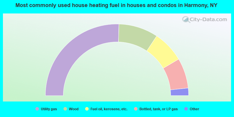
- 50.9%Utility gas
- 17.8%Wood
- 14.3%Fuel oil, kerosene, etc.
- 13.6%Bottled, tank, or LP gas
- 2.9%Other fuel
- 0.6%Electricity
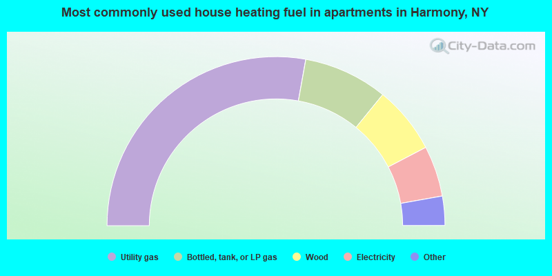
- 55.6%Utility gas
- 16.1%Bottled, tank, or LP gas
- 12.9%Wood
- 9.7%Electricity
- 3.2%Other fuel
- 2.4%Fuel oil, kerosene, etc.
Harmony compared to New York state average:
- Median house value significantly below state average.
- Unemployed percentage below state average.
- Black race population percentage significantly below state average.
- Hispanic race population percentage significantly below state average.
- Foreign-born population percentage significantly below state average.
- Renting percentage significantly below state average.
- Length of stay since moving in significantly above state average.
- Number of rooms per house significantly below state average.
- House age significantly below state average.
- Number of college students below state average.
- Percentage of population with a bachelor's degree or higher significantly below state average.