Hammonville, Kentucky
Submit your own pictures of this place and show them to the world
- OSM Map
- General Map
- Google Map
- MSN Map

| Males: 1,007 | |
| Females: 999 |
| Median resident age: | 36.8 years |
| Kentucky median age: | 35.9 years |
Zip code: 42757
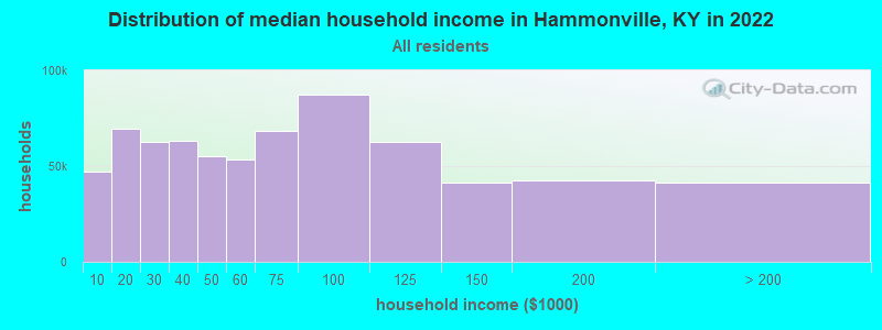
| Hammonville: | $45,456 |
| KY: | $59,341 |
Estimated per capita income in 2022: $24,365 (it was $13,605 in 2000)
Hammonville CCD income, earnings, and wages data
Estimated median house or condo value in 2022: $129,417 (it was $58,700 in 2000)
| Hammonville: | $129,417 |
| KY: | $196,300 |
Detailed information about poverty and poor residents in Hammonville, KY
Compare current foreclosures near Hammonville, KY:
| Photo | Address | Area | Beds / Baths | Price | Details |
|---|---|---|---|---|---|

|
#1
Flint Hill Rd
Sonora, KY 42776
|
1,498 sq. feet
|
3 baths 3 beds |
show details | |

|
#2
Wells Rd
Buffalo, KY 42716
|
1,008 sq. feet
|
1 baths 2 beds |
show details | |

|
#3
Vaughn Ave
Hodgenville, KY 42748
|
1,092 sq. feet
|
1 baths 3 beds |
show details | |

|
#4
Main St
Munfordville, KY 42765
|
1,890 sq. feet
|
2 baths 4 beds |
show details | |

|
#5
Hunting Trail Rd
Munfordville, KY 42765
|
2,150 sq. feet
|
2 baths 3 beds |
show details | |

|
#6
Elk St
Munfordville, KY 42765
|
1,120 sq. feet
|
1 baths 3 beds |
show details | |

|
#7
Elk St
Munfordville, KY 42765
|
1,084 sq. feet
|
1 baths 2 beds |
show details | |

|
#8
N Buckner Ave
Munfordville, KY 42765
|
1,352 sq. feet
|
1 baths 3 beds |
show details | |

|
#9
Lone Star Rd
Upton, KY 42784
|
1,792 sq. feet
|
2 baths 3 beds |
show details | |

|
#10
S Dixie Hwy
Munfordville, KY 42765
|
1,590 sq. feet
|
1 baths 4 beds |
show details |
| Photo | Address | Area | Beds / Baths | Price | Details |
|---|---|---|---|---|---|

|
#11
Hammonsville Rd
Bonnieville, KY 42713
|
1,512 sq. feet
|
2 baths 3 beds |
show details | |

|
#12
N Jackson Hwy
Magnolia, KY 42757
|
1,334 sq. feet
|
1 baths 3 beds |
show details | |

|
#13
N L And N Turnpike Rd
Buffalo, KY 42716
|
988 sq. feet
|
1 baths 2 beds |
show details | |

|
#14
Glendale Rd
Hodgenville, KY 42748
|
1,324 sq. feet
|
1 baths 3 beds |
show details | |

|
#15
Caple Ave
Hodgenville, KY 42748
|
1,232 sq. feet
|
1 baths 3 beds |
show details | |

|
#16
Leafdale Rd
Hodgenville, KY 42748
|
1,176 sq. feet
|
1 baths 3 beds |
show details | |

|
#17
New St
Horse Cave, KY 42749
|
1,765 sq. feet
|
2 baths 3 beds |
show details | |

|
#18
Sportsman Lake Rd
Elizabethtown, KY 42701
|
1,680 sq. feet
|
1 baths 3 beds |
show details | |

|
#19
Comer Ave
Horse Cave, KY 42749
|
1,089 sq. feet
|
1 baths 2 beds |
show details | |

|
#20
Railroad Dr
Hodgenville, KY 42748
|
804 sq. feet
|
1 baths 2 beds |
show details |
| Photo | Address | Area | Beds / Baths | Price | Details |
|---|---|---|---|---|---|

|
#21
Center Point Rd
Sonora, KY 42776
|
1,668 sq. feet
|
1 baths 3 beds |
show details | |

|
#22
Grayson St
Upton, KY 42784
|
1,125 sq. feet
|
1 baths 3 beds |
show details | |

|
#23
W Western Ave
Sonora, KY 42776
|
1,064 sq. feet
|
1 baths 3 beds |
show details | |

|
#24
New Jackson Hwy
Hodgenville, KY 42748
|
1,815 sq. feet
|
2 baths 3 beds |
show details | |

|
#25
Julia Ln
Munfordville, KY 42765
|
1,536 sq. feet
|
2 baths 4 beds |
show details | |

|
#26
Hardyville Rd
Munfordville, KY 42765
|
1,217 sq. feet
|
1 baths 2 beds |
show details | |

|
#27
Campground Rd
Bonnieville, KY 42713
|
1,168 sq. feet
|
1 baths 3 beds |
show details | |

|
#28
Mill Rd
Magnolia, KY 42757
|
1,324 sq. feet
|
1 baths 3 beds |
show details | |

|
#29
Jones St
Upton, KY 42784
|
1,232 sq. feet
|
1 baths 3 beds |
show details | |

|
#30
Crissy St
Upton, KY 42784
|
1,490 sq. feet
|
2 baths 3 beds |
show details |
| Photo | Address | Area | Beds / Baths | Price | Details |
|---|---|---|---|---|---|

|
#31
Mount Tabor Rd
Buffalo, KY 42716
|
1,248 sq. feet
|
2 baths 3 beds |
show details | |

|
#32
College St
Hodgenville, KY 42748
|
1,352 sq. feet
|
1 baths - beds |
show details | |

|
#33
Stiles Rd
New Haven, KY 40051
|
- sq. feet
|
- baths - beds |
show details | |

|
#34
Hedge Apple Ln
Sonora, KY 42776
|
- sq. feet
|
- baths - beds |
show details | |

|
#35
Wright Ln
Bonnieville, KY 42713
|
- sq. feet
|
- baths - beds |
show details | |

|
#36
Vera Ct
Sonora, KY 42776
|
- sq. feet
|
- baths - beds |
show details | |

|
#37
Highway 1048
Center, KY 42214
|
- sq. feet
|
- baths - beds |
show details | |

|
#38
Highway 566
Magnolia, KY 42757
|
- sq. feet
|
- baths - beds |
show details | |

|
#39
Highway 218
Greensburg, KY 42743
|
- sq. feet
|
- baths - beds |
show details | |

|
#40
Straley Aly
Mount Sherman, KY 42764
|
- sq. feet
|
- baths - beds |
show details |
| Photo | Address | Area | Beds / Baths | Price | Details |
|---|---|---|---|---|---|

|
#41
Phillips Ln
Hodgenville, KY 42748
|
- sq. feet
|
- baths - beds |
show details | |

|
#42
Phillips Ln
Hodgenville, KY 42748
|
- sq. feet
|
- baths - beds |
show details | |

|
#43
Shady Bower Ln
Sonora, KY 42776
|
- sq. feet
|
- baths - beds |
show details | |

|
#44
Shipp Rd
Magnolia, KY 42757
|
- sq. feet
|
- baths - beds |
show details | |

|
#45
Harper Dr Apt 10
Horse Cave, KY 42749
|
- sq. feet
|
- baths - beds |
show details | |

|
#46
L And N Turnpike Rd
Horse Cave, KY 42749
|
- sq. feet
|
- baths - beds |
show details | |

|
#47
Pierce Donansburg Rd
Greensburg, KY 42743
|
- sq. feet
|
- baths - beds |
show details | |

|
#48
Waterloo Rd
Horse Cave, KY 42749
|
- sq. feet
|
- baths - beds |
show details | |

|
#49
Allison Dr
Sonora, KY 42776
|
- sq. feet
|
- baths - beds |
show details | |

|
Check over 1 million property listings on Foreclosure.com!
|
browse all offers | |||

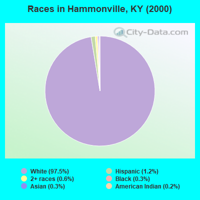
- 1,87497.5%White alone
- 241.2%Hispanic
- 120.6%Two or more races
- 50.3%Black alone
- 50.3%Asian alone
- 30.2%American Indian alone
Races in Hammonville detailed stats: ancestries, foreign born residents, place of birth
 Recent articles from our blog. Our writers, many of them Ph.D. graduates or candidates, create easy-to-read articles on a wide variety of topics.
Current Local Time: CST time zone
Elevation: 700 feet
Land area: 79.1 square miles.
Population density: 25 people per square mile (very low).

| Hammonville CCD: | 0.5% ($309) |
| Kentucky: | 0.8% ($610) |
Nearest city with pop. 50,000+: Louisville, KY  (59.0 miles , pop. 256,231).
Nearest city with pop. 1,000,000+: Chicago, IL (325.3 miles , pop. 2,896,016).
Nearest cities:
), ), ), ), ), )Latitude: 37.38 N, Longitude: 85.76 W
Area code commonly used in this area: 270

| Here: | 4.0% |
| Kentucky: | 3.8% |
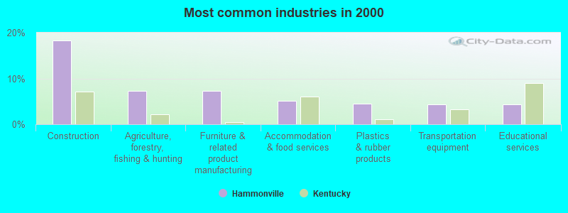
- Construction (18.3%)
- Agriculture, forestry, fishing & hunting (7.2%)
- Furniture & related product manufacturing (7.2%)
- Accommodation & food services (5.1%)
- Plastics & rubber products (4.5%)
- Transportation equipment (4.4%)
- Educational services (4.3%)
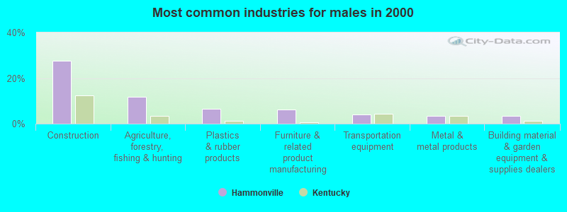
- Construction (27.6%)
- Agriculture, forestry, fishing & hunting (11.6%)
- Plastics & rubber products (6.5%)
- Furniture & related product manufacturing (6.3%)
- Transportation equipment (4.1%)
- Metal & metal products (3.6%)
- Building material & garden equipment & supplies dealers (3.4%)
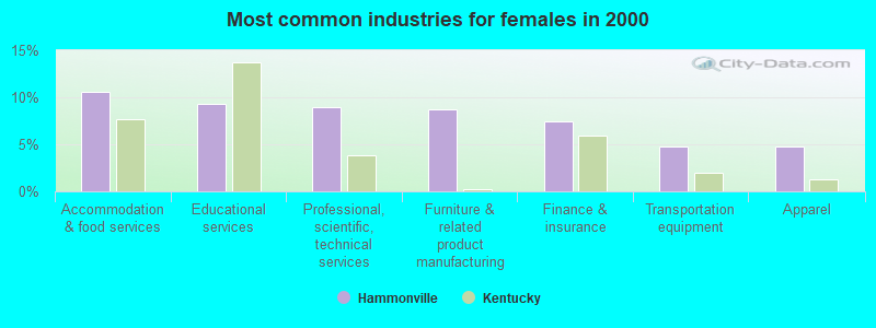
- Accommodation & food services (10.6%)
- Educational services (9.3%)
- Professional, scientific, technical services (9.0%)
- Furniture & related product manufacturing (8.7%)
- Finance & insurance (7.4%)
- Transportation equipment (4.8%)
- Apparel (4.8%)
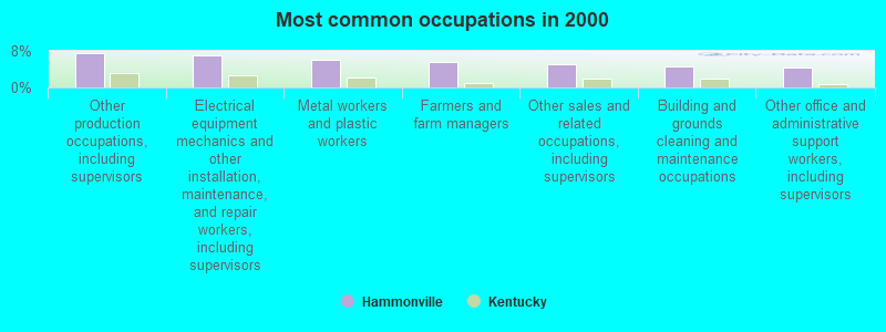
- Other production occupations, including supervisors (7.5%)
- Electrical equipment mechanics and other installation, maintenance, and repair workers, including supervisors (7.0%)
- Metal workers and plastic workers (6.1%)
- Farmers and farm managers (5.6%)
- Other sales and related occupations, including supervisors (5.0%)
- Building and grounds cleaning and maintenance occupations (4.6%)
- Other office and administrative support workers, including supervisors (4.4%)
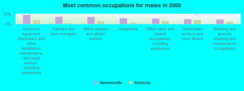
- Electrical equipment mechanics and other installation, maintenance, and repair workers, including supervisors (11.2%)
- Farmers and farm managers (9.1%)
- Metal workers and plastic workers (8.7%)
- Carpenters (7.1%)
- Other sales and related occupations, including supervisors (6.9%)
- Driver/sales workers and truck drivers (6.3%)
- Building and grounds cleaning and maintenance occupations (5.7%)
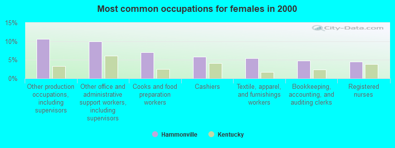
- Other production occupations, including supervisors (10.6%)
- Other office and administrative support workers, including supervisors (10.0%)
- Cooks and food preparation workers (7.1%)
- Cashiers (5.8%)
- Textile, apparel, and furnishings workers (5.5%)
- Bookkeeping, accounting, and auditing clerks (4.8%)
- Registered nurses (4.5%)
Average climate in Hammonville, Kentucky
Based on data reported by over 4,000 weather stations


(lower is better)
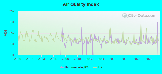
Air Quality Index (AQI) level in 2022 was 63.2. This is about average.
| City: | 63.2 |
| U.S.: | 72.6 |
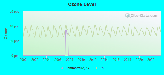
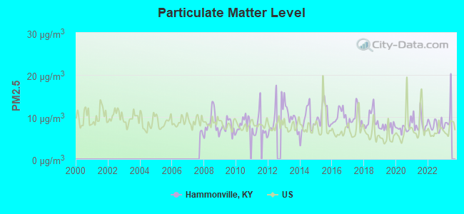
Particulate Matter (PM2.5) [µg/m3] level in 2022 was 8.02. This is about average. Closest monitor was 23.4 miles away from the city center.
| City: | 8.02 |
| U.S.: | 8.11 |
Tornado activity:
Hammonville-area historical tornado activity is slightly above Kentucky state average. It is 50% greater than the overall U.S. average.
On 4/3/1974, a category F4 (max. wind speeds 207-260 mph) tornado 19.2 miles away from the Hammonville place center injured 56 people and caused between $500,000 and $5,000,000 in damages.
On 4/27/1971, a category F4 tornado 23.1 miles away from the place center killed 6 people and injured 58 people.
Earthquake activity:
Hammonville-area historical earthquake activity is significantly above Kentucky state average. It is 133% greater than the overall U.S. average.On 4/18/2008 at 09:36:59, a magnitude 5.4 (5.1 MB, 4.8 MS, 5.4 MW, 5.2 MW, Class: Moderate, Intensity: VI - VII) earthquake occurred 137.9 miles away from Hammonville center
On 7/27/1980 at 18:52:21, a magnitude 5.2 (5.1 MB, 4.7 MS, 5.0 UK, 5.2 UK) earthquake occurred 114.5 miles away from the city center
On 4/18/2008 at 09:36:59, a magnitude 5.2 (5.2 MW, Depth: 8.9 mi) earthquake occurred 137.9 miles away from the city center
On 6/18/2002 at 17:37:15, a magnitude 5.0 (4.3 MB, 4.6 MW, 5.0 LG) earthquake occurred 118.5 miles away from Hammonville center
On 6/10/1987 at 23:48:54, a magnitude 5.1 (4.9 MB, 4.4 MS, 4.6 MS, 5.1 LG) earthquake occurred 152.9 miles away from Hammonville center
On 4/18/2008 at 15:14:16, a magnitude 4.8 (4.5 MB, 4.8 MW, 4.6 MW, Class: Light, Intensity: IV - V) earthquake occurred 137.0 miles away from the city center
Magnitude types: regional Lg-wave magnitude (LG), body-wave magnitude (MB), surface-wave magnitude (MS), moment magnitude (MW)
Natural disasters:
The number of natural disasters in Hart County (16) is near the US average (15).Major Disasters (Presidential) Declared: 12
Emergencies Declared: 3
Causes of natural disasters: Floods: 9, Storms: 8, Winter Storms: 5, Tornadoes: 4, Mudslides: 3, Snows: 2, Blizzard: 1, Freeze: 1, Hurricane: 1, Landslide: 1, Snowfall: 1, Snowstorm: 1, Wind: 1, Other: 1 (Note: some incidents may be assigned to more than one category).
Colleges/universities with over 2000 students nearest to Hammonville:
- Campbellsville University (about 23 miles; Campbellsville, KY; Full-time enrollment: 2,948)
- Elizabethtown Community and Technical College (about 24 miles; Elizabethtown, KY; FT enrollment: 3,762)
- Lindsey Wilson College (about 32 miles; Columbia, KY; FT enrollment: 2,552)
- Western Kentucky University (about 48 miles; Bowling Green, KY; FT enrollment: 16,942)
- Southcentral Kentucky Community and Technical College (about 49 miles; Bowling Green, KY; FT enrollment: 2,794)
- Sullivan University (about 59 miles; Louisville, KY; FT enrollment: 5,129)
- University of Louisville (about 59 miles; Louisville, KY; FT enrollment: 16,640)
Points of interest:
Notable locations in Hammonville: Aetna Furnace (A), Linwood Volunteer Fire Department (B). Display/hide their locations on the map
Churches in Hammonville include: Friendship Church (A), Glen Lily Church (B), High Hickory Church (C), Knoxes Creek Baptist Church (D), Mount Pisgah Church (E), Mount Zion Separate Baptist Church (F), Union Church (G), Shiboley Church (H). Display/hide their locations on the map
Cemeteries: Perkins Cemetery (1), Akin Cemetery (2), Crump Cemetery (3), Kessler Cemetery (4), Dobson Cemetery (5), Williams Cemetery (6), Edwards Cemetery (7). Display/hide their locations on the map
Streams, rivers, and creeks: Tampa Branch (A), Martis Branch (B), Brushy Fork (C), Lynn Camp Creek (D), Locust Branch (E), Lindy Creek (F), Laurel Branch (G), Knox Creek (H), Pottinger Creek (I). Display/hide their locations on the map
| This place: | 2.6 people |
| Kentucky: | 2.5 people |
| This place: | 73.1% |
| Whole state: | 66.9% |
| This place: | 6.1% |
| Whole state: | 6.4% |
Likely homosexual households (counted as self-reported same-sex unmarried-partner households)
- Lesbian couples: 0.4% of all households
- Gay men: 0.0% of all households
| This place: | 20.8% |
| Whole state: | 15.8% |
| This place: | 6.8% |
| Whole state: | 6.6% |
For population 15 years and over in Hammonville:
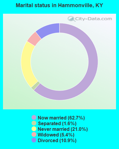
- Never married: 21.0%
- Now married: 62.7%
- Separated: 1.6%
- Widowed: 5.4%
- Divorced: 10.9%
For population 25 years and over in Hammonville:
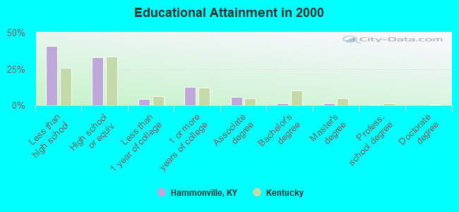
- High school or higher: 59.3%
- Bachelor's degree or higher: 3.5%
- Graduate or professional degree: 1.9%
- Unemployed: 4.9%
- Mean travel time to work (commute): 38.5 minutes
| Here: | 13.9 |
| Kentucky average: | 13.8 |
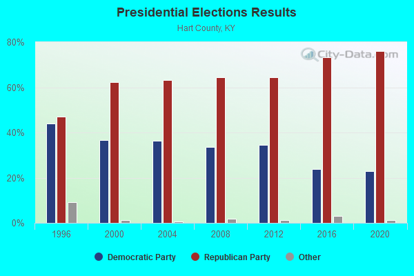
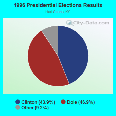
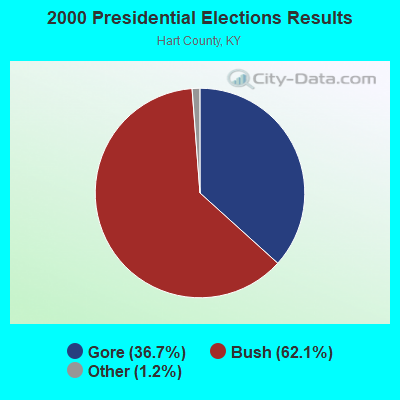
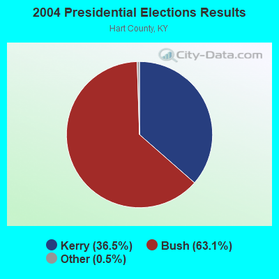
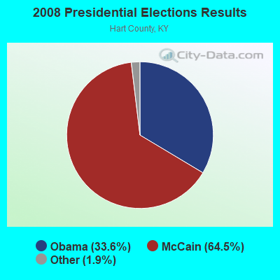
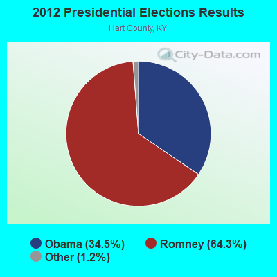
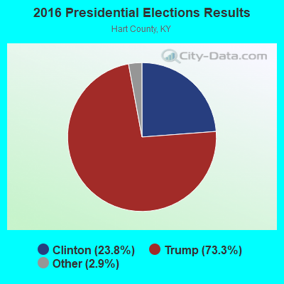
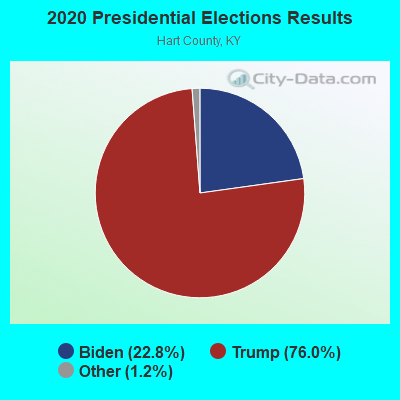
Graphs represent county-level data. Detailed 2008 Election Results
Religion statistics for Hammonville, KY (based on Hart County data)
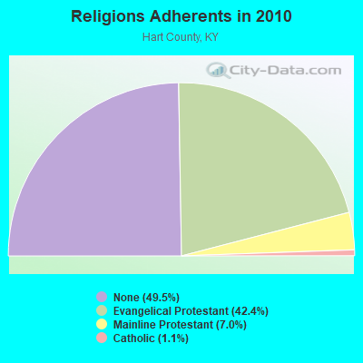
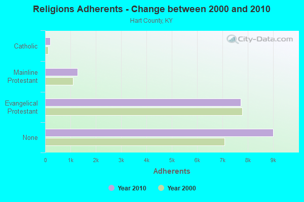
| Religion | Adherents | Congregations |
|---|---|---|
| Evangelical Protestant | 7,710 | 51 |
| Mainline Protestant | 1,277 | 13 |
| Catholic | 205 | 1 |
| None | 9,007 | - |
Food Environment Statistics:
| Hart County: | 3.81 / 10,000 pop. |
| State: | 2.19 / 10,000 pop. |
| Hart County: | 0.54 / 10,000 pop. |
| Kentucky: | 0.74 / 10,000 pop. |
| Here: | 7.63 / 10,000 pop. |
| Kentucky: | 4.36 / 10,000 pop. |
| Hart County: | 7.63 / 10,000 pop. |
| Kentucky: | 5.74 / 10,000 pop. |
| This county: | 10.5% |
| Kentucky: | 11.0% |
| Hart County: | 30.6% |
| Kentucky: | 30.0% |
| Hart County: | 17.7% |
| Kentucky: | 15.9% |
Strongest AM radio stations in Hammonville:
- WHAS (840 AM; 50 kW; LOUISVILLE, KY; Owner: CLEAR CHANNEL BROADCASTING LICENSES, INC.)
- WLOC (1150 AM; 1 kW; MUNFORDVILLE, KY; Owner: HART COUNTY COMMUNICATIONS, INC.)
- WXAM (1430 AM; 1 kW; BUFFALO, KY; Owner: MARK GOODMAN PRODUCTIONS, INC.)
- WSM (650 AM; 50 kW; NASHVILLE, TN; Owner: GAYLORD ENTERTAINMENT COMPANY)
- WAMB (1160 AM; 50 kW; DONELSON, TN; Owner: GREAT SOUTHERN BROADCASTING COMPANY, INC.)
- WKDA (1200 AM; 50 kW; NASHVILLE, TN; Owner: RADIO NASHVILLE, INC.)
- WLAC (1510 AM; 50 kW; NASHVILLE, TN; Owner: CAPSTAR TX LIMITED PARTNERSHIP)
- WNQM (1300 AM; 50 kW; NASHVILLE, TN; Owner: WNQM. INC.)
- WKVL (850 AM; daytime; 50 kW; KNOXVILLE, TN; Owner: HORNE RADIO, LLC)
- WLW (700 AM; 50 kW; CINCINNATI, OH; Owner: JACOR BROADCASTING CORPORATION)
- WAKY (1540 AM; 1 kW; GREENSBURG, KY; Owner: GREEN COUNTY CBC, INC.)
- WKCT (930 AM; 5 kW; BOWLING GREEN, KY; Owner: DAILY NEWS BROADCASTING CO.)
- WWAM (820 AM; daytime; 50 kW; JASPER, TN; Owner: SHELTON BROADCASTING SYSTEM)
Strongest FM radio stations in Hammonville:
- WJCR-FM (90.1 FM; UPTON, KY; Owner: FM 90.1, INC.)
- WCLU-FM (102.3 FM; MUNFORDVILLE, KY; Owner: ROYSE RADIO, INC)
- WGRK-FM (103.1 FM; GREENSBURG, KY; Owner: GREEN COUNTY CBC, INC.)
- WHHT (106.7 FM; HORSE CAVE, KY; Owner: NEWBERRY BROADCASTING, INC.)
- WASE (103.5 FM; RADCLIFF, KY; Owner: W & B BROADCASTING, INC.)
- WKUE (90.9 FM; ELIZABETHTOWN, KY; Owner: WESTERN KENTUCKY UNIVERSITY)
- WGGC (95.1 FM; GLASGOW, KY; Owner: HERITAGE COMMUNICATIONS, INC.)
- WQXE (98.3 FM; ELIZABETHTOWN, KY; Owner: SKYTOWER COMMUNICATIONS-E'TOWN, INC.)
- WPTQ (103.7 FM; CAVE CITY, KY; Owner: NEWBERRY BROADCASTING, INC.)
- WKMO (106.3 FM; HODGENVILLE, KY; Owner: ELIZABETHTOWN CBC, INC.)
- WCKQ (104.1 FM; CAMPBELLSVILLE, KY; Owner: CBC OF MARION & TAYLOR COUNTIES INC)
- WVLC (99.9 FM; MANNSVILLE, KY; Owner: PATRICIA RODGERS)
- WKLX (100.7 FM; BROWNSVILLE, KY; Owner: CHARLES M. ANDERSON)
- WLVK (105.5 FM; FORT KNOX, KY; Owner: BIG CAT BROADCASTING, INC.)
- WTHX (107.3 FM; LEBANON JUNCTION, KY; Owner: ELIZABETHTOWN CBC, INC.)
TV broadcast stations around Hammonville:
- WBKI-TV (Channel 34; CAMPBELLSVILLE, KY; Owner: LOUISVILLE COMMUNICATIONS, LLC)
- WKZT-TV (Channel 23; ELIZABETHTOWN, KY; Owner: KENTUCKY AUTHORITY FOR EDUCATIONAL TV)
- W39CJ (Channel 39; ELIZABETHTOWN, KY; Owner: TRINITY BROADCASTING NETWORK)
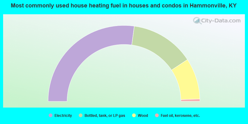
- 54.3%Electricity
- 27.1%Bottled, tank, or LP gas
- 17.5%Wood
- 1.0%Fuel oil, kerosene, etc.
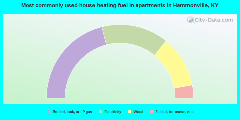
- 42.0%Bottled, tank, or LP gas
- 29.5%Electricity
- 22.7%Wood
- 5.7%Fuel oil, kerosene, etc.
Hammonville compared to Kentucky state average:
- Median house value below state average.
- Unemployed percentage significantly below state average.
- Black race population percentage significantly below state average.
- Hispanic race population percentage significantly below state average.
- Median age below state average.
- Foreign-born population percentage significantly below state average.
- Renting percentage below state average.
- Length of stay since moving in significantly above state average.
- Number of rooms per house significantly below state average.
- House age significantly below state average.
- Number of college students below state average.
- Percentage of population with a bachelor's degree or higher significantly below state average.