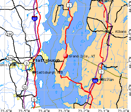
Grand Isle, Vermont

Grand Isle: Sunset on a quite water

Grand Isle: Sunrise over Mt Manfield
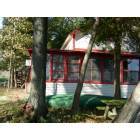
Grand Isle: The old Camp
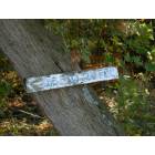
Grand Isle: One Dead Cow Lane
- add
your
Submit your own pictures of this town and show them to the world
- OSM Map
- General Map
- Google Map
- MSN Map
Population change since 2000: +5.7%
 |
| Males: 1,046 | |
| Females: 1,021 |
| Median resident age: | 45.3 years |
| Vermont median age: | 45.8 years |
Zip codes: 05458.
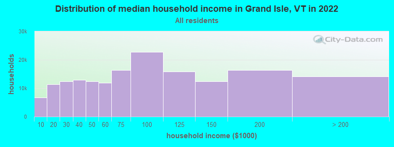
| Grand Isle: | $97,805 |
| VT: | $73,991 |
Estimated per capita income in 2022: $50,874 (it was $22,955 in 2000)
Grand Isle town income, earnings, and wages data
Estimated median house or condo value in 2022: $408,811 (it was $135,600 in 2000)
| Grand Isle: | $408,811 |
| VT: | $304,700 |
Mean prices in 2022: all housing units: $426,640; detached houses: $457,163; townhouses or other attached units: $374,101; in 2-unit structures: $295,893; in 3-to-4-unit structures: over $1,000,000; mobile homes: $147,838
Detailed information about poverty and poor residents in Grand Isle, VT


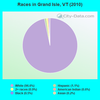
- 1,99796.6%White alone
- 231.1%Hispanic
- 190.9%Two or more races
- 120.6%American Indian alone
- 110.5%Black alone
- 50.2%Asian alone
Races in Grand Isle detailed stats: ancestries, foreign born residents, place of birth
According to our research of Vermont and other state lists, there were 3 registered sex offenders living in Grand Isle, Vermont as of May 17, 2024.
The ratio of all residents to sex offenders in Grand Isle is 689 to 1.
The ratio of registered sex offenders to all residents in this city is lower than the state average.
 Recent articles from our blog. Our writers, many of them Ph.D. graduates or candidates, create easy-to-read articles on a wide variety of topics.

 | Another 'Where Should I Live in Vermont' Post (11 replies) |
| Planning a vacation to Burlington, VT. (28 replies) |
| Yet another moving to Vermont thread - Burlington or Montpelier area (27 replies) |
| Sewage in Lake Champlain 🤮 (6 replies) |
| Living in South Burlington versus Essex Junction (4 replies) |
| Vermont stores that you remember (12 replies) |
Latest news from Grand Isle, VT collected exclusively by city-data.com from local newspapers, TV, and radio stations
Ancestries: French (17.7%), English (17.6%), French Canadian (12.7%), German (12.6%), Irish (11.8%), United States (7.8%).
Current Local Time: EST time zone
Elevation: 169 feet
Land area: 16.5 square miles.
Population density: 125 people per square mile (very low).
66 residents are foreign born (1.4% North America, 1.4% Europe).
| This town: | 3.4% |
| Vermont: | 3.8% |
| Grand Isle town: | 1.8% ($2,486) |
| Vermont: | 2.0% ($2,196) |
Nearest city with pop. 50,000+: Schenectady, NY  (135.6 miles , pop. 61,821).
Nearest city with pop. 200,000+: Boston, MA (199.2 miles , pop. 589,141).
Nearest city with pop. 1,000,000+: Bronx, NY (268.9 miles , pop. 1,332,650).
Nearest cities:
), ), )Latitude: 44.71 N, Longitude: 73.31 W
Area code: 802

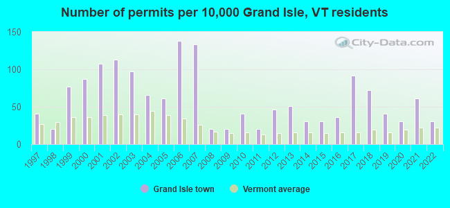
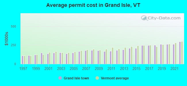
Single-family new house construction building permits:
- 2022: 6 buildings, average cost: $298,700
- 2021: 12 buildings, average cost: $262,500
- 2020: 6 buildings, average cost: $265,300
- 2019: 8 buildings, average cost: $262,400
- 2018: 14 buildings, average cost: $249,800
- 2017: 18 buildings, average cost: $248,100
- 2016: 7 buildings, average cost: $246,000
- 2015: 6 buildings, average cost: $211,200
- 2014: 6 buildings, average cost: $211,200
- 2013: 10 buildings, average cost: $192,300
- 2012: 9 buildings, average cost: $182,800
- 2011: 4 buildings, average cost: $172,800
- 2010: 8 buildings, average cost: $169,100
- 2009: 4 buildings, average cost: $180,600
- 2008: 4 buildings, average cost: $182,400
- 2007: 26 buildings, average cost: $178,500
- 2006: 27 buildings, average cost: $166,400
- 2005: 12 buildings, average cost: $149,300
- 2004: 13 buildings, average cost: $138,800
- 2003: 19 buildings, average cost: $151,600
- 2002: 22 buildings, average cost: $147,100
- 2001: 21 buildings, average cost: $138,100
- 2000: 17 buildings, average cost: $147,700
- 1999: 15 buildings, average cost: $122,500
- 1998: 4 buildings, average cost: $114,400
- 1997: 8 buildings, average cost: $111,800
| Here: | 1.9% |
| Vermont: | 2.0% |
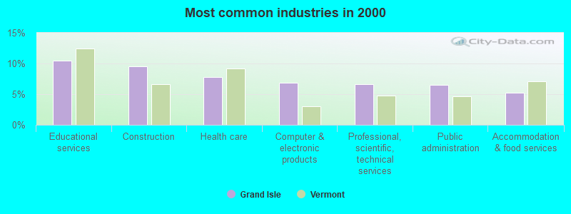
- Educational services (10.5%)
- Construction (9.5%)
- Health care (7.8%)
- Computer & electronic products (6.8%)
- Professional, scientific, technical services (6.6%)
- Public administration (6.5%)
- Accommodation & food services (5.2%)
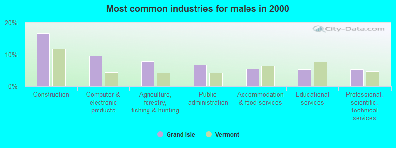
- Construction (16.8%)
- Computer & electronic products (9.7%)
- Agriculture, forestry, fishing & hunting (7.8%)
- Public administration (6.8%)
- Accommodation & food services (5.7%)
- Educational services (5.5%)
- Professional, scientific, technical services (5.5%)
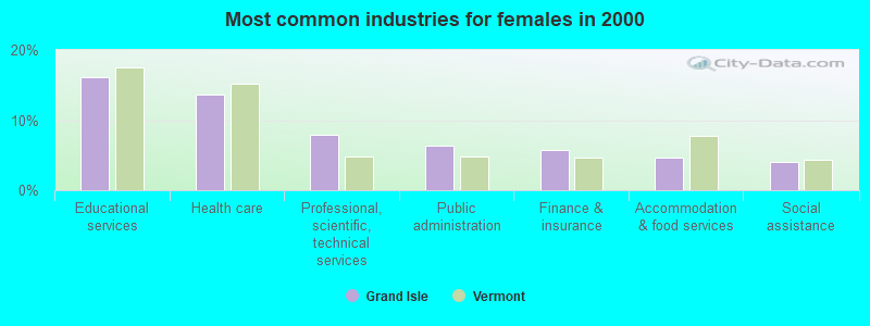
- Educational services (16.1%)
- Health care (13.6%)
- Professional, scientific, technical services (7.9%)
- Public administration (6.3%)
- Finance & insurance (5.7%)
- Accommodation & food services (4.7%)
- Social assistance (4.1%)
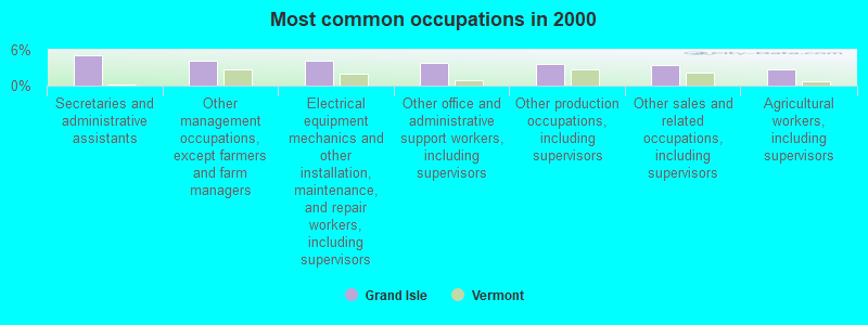
- Secretaries and administrative assistants (5.0%)
- Other management occupations, except farmers and farm managers (4.2%)
- Electrical equipment mechanics and other installation, maintenance, and repair workers, including supervisors (4.1%)
- Other office and administrative support workers, including supervisors (3.8%)
- Other production occupations, including supervisors (3.7%)
- Other sales and related occupations, including supervisors (3.4%)
- Agricultural workers, including supervisors (2.7%)
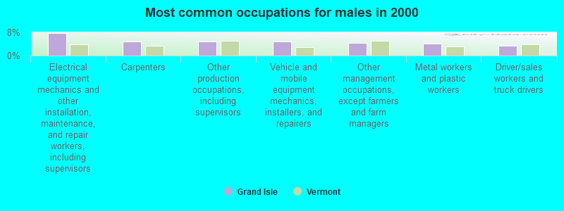
- Electrical equipment mechanics and other installation, maintenance, and repair workers, including supervisors (7.8%)
- Carpenters (4.9%)
- Other production occupations, including supervisors (4.7%)
- Vehicle and mobile equipment mechanics, installers, and repairers (4.7%)
- Other management occupations, except farmers and farm managers (4.4%)
- Metal workers and plastic workers (4.0%)
- Driver/sales workers and truck drivers (3.5%)
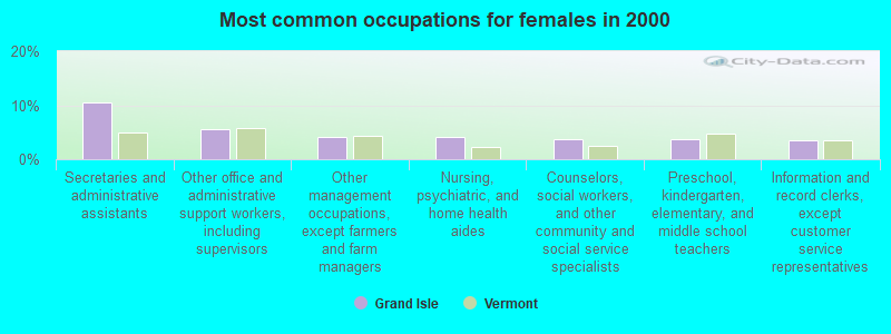
- Secretaries and administrative assistants (10.6%)
- Other office and administrative support workers, including supervisors (5.5%)
- Other management occupations, except farmers and farm managers (4.1%)
- Nursing, psychiatric, and home health aides (4.1%)
- Counselors, social workers, and other community and social service specialists (3.7%)
- Preschool, kindergarten, elementary, and middle school teachers (3.7%)
- Information and record clerks, except customer service representatives (3.5%)
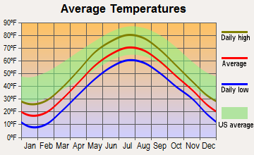
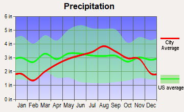
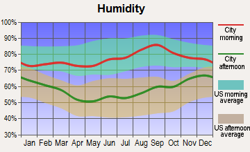
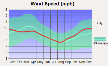
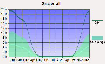
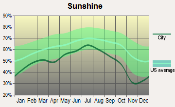
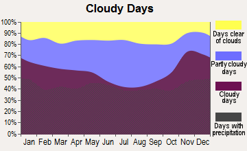
Average climate in Grand Isle, Vermont
Based on data reported by over 4,000 weather stations
(lower is better)
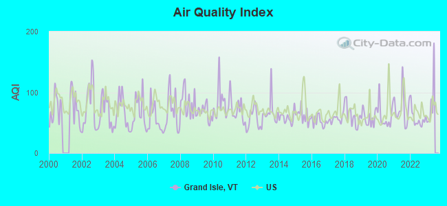
Air Quality Index (AQI) level in 2022 was 56.4. This is better than average.
| City: | 56.4 |
| U.S.: | 72.6 |
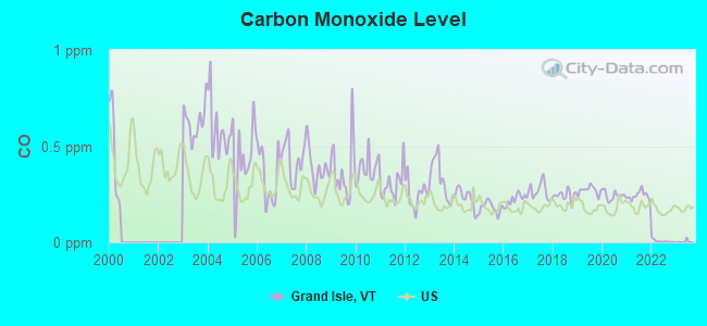
Carbon Monoxide (CO) [ppm] level in 2022 was 0.00585. This is significantly better than average. Closest monitor was 16.8 miles away from the city center.
| City: | 0.00585 |
| U.S.: | 0.25132 |
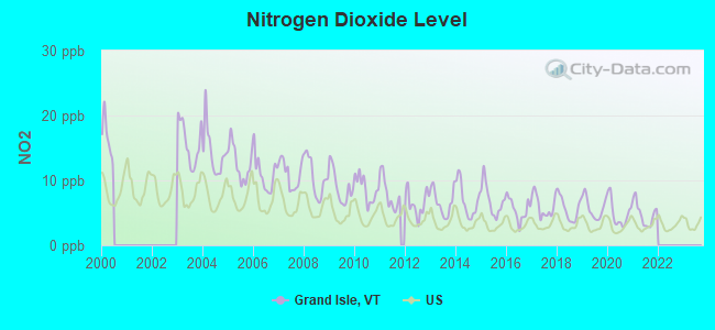
Nitrogen Dioxide (NO2) [ppb] level in 2021 was 4.81. This is about average. Closest monitor was 16.8 miles away from the city center.
| City: | 4.81 |
| U.S.: | 5.11 |
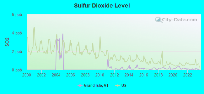
Sulfur Dioxide (SO2) [ppb] level in 2022 was 0.0619. This is significantly better than average. Closest monitor was 17.0 miles away from the city center.
| City: | 0.0619 |
| U.S.: | 1.5147 |
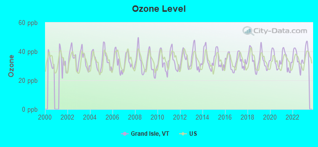
Ozone [ppb] level in 2022 was 34.8. This is about average. Closest monitor was 16.8 miles away from the city center.
| City: | 34.8 |
| U.S.: | 33.3 |
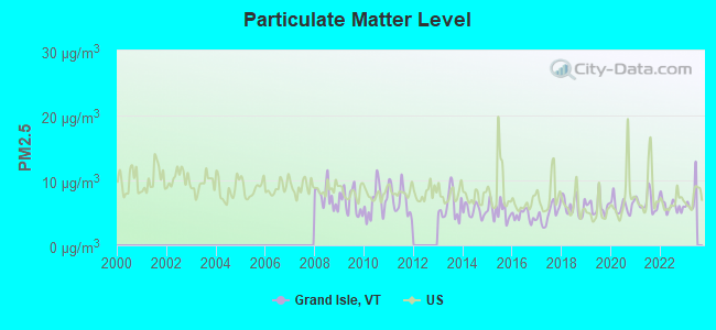
Particulate Matter (PM2.5) [µg/m3] level in 2022 was 6.11. This is better than average. Closest monitor was 16.7 miles away from the city center.
| City: | 6.11 |
| U.S.: | 8.11 |
Earthquake activity:
Grand Isle-area historical earthquake activity is significantly above Vermont state average. It is 72% smaller than the overall U.S. average.On 4/20/2002 at 10:50:47, a magnitude 5.3 (5.3 ML, Depth: 3.0 mi, Class: Moderate, Intensity: VI - VII) earthquake occurred 23.8 miles away from the city center
On 4/20/2002 at 10:50:47, a magnitude 5.2 (5.2 MB, 4.2 MS, 5.2 MW, 5.0 MW) earthquake occurred 25.6 miles away from the city center
On 10/7/1983 at 10:18:46, a magnitude 5.3 (5.1 MB, 5.3 LG, 5.1 ML) earthquake occurred 73.4 miles away from the city center
On 1/19/1982 at 00:14:42, a magnitude 4.7 (4.5 MB, 4.7 MD, 4.5 LG, Class: Light, Intensity: IV - V) earthquake occurred 119.2 miles away from the city center
On 10/16/2012 at 23:12:25, a magnitude 4.7 (4.7 ML, Depth: 10.0 mi) earthquake occurred 152.4 miles away from the city center
On 4/20/2002 at 11:04:42, a magnitude 3.7 (3.7 ML, Depth: 3.1 mi, Class: Light, Intensity: II - III) earthquake occurred 24.4 miles away from Grand Isle center
Magnitude types: regional Lg-wave magnitude (LG), body-wave magnitude (MB), duration magnitude (MD), local magnitude (ML), surface-wave magnitude (MS), moment magnitude (MW)
Natural disasters:
The number of natural disasters in Grand Isle County (12) is smaller than the US average (15).Major Disasters (Presidential) Declared: 7
Emergencies Declared: 2
Causes of natural disasters: Floods: 6, Storms: 5, Heavy Rain: 1, Hurricane: 1, Ice Storm: 1, Landslide: 1, Snow: 1, Snowstorm: 1, Tornado: 1, Tropical Storm: 1, Winter Storm: 1, Other: 1 (Note: some incidents may be assigned to more than one category).
Hospitals and medical centers near Grand Isle:
- HOSPICE OF THE NORTH COUNTRY INC (Hospital, about 8 miles away; PLATTSBURGH, NY)
- CLINTON CO DEPT HEALTH CHHA (Home Health Center, about 8 miles away; PLATTSBURGH, NY)
- EVERGREEN VALLEY NURSING HOME (Nursing Home, about 8 miles away; PLATTSBURGH, NY)
- CLINTON COUNTY NURSING HOME (Nursing Home, about 8 miles away; PLATTSBURGH, NY)
- CVPH MEDICAL CENTER RENAL CENTER (Dialysis Facility, about 8 miles away; PLATTSBURGH, NY)
- CHAMPLAIN VALLEY PHYSICIANS HOSPITAL MEDICAL CTR Acute Care Hospitals (about 8 miles away; PLATTSBURGH, NY)
- MEADOWBROOK HEALTHCARE (Nursing Home, about 9 miles away; PLATTSBURGH, NY)
Airports and other landing facilities located in Grand Isle:
See details about Airports and other landing facilities located in Grand Isle, VTAmtrak stations near Grand Isle:
- 8 miles: PLATTSBURGH (BRIDGE ST.) . Services: enclosed waiting area, public restrooms, public payphones, free short-term parking, free long-term parking, call for car rental service, call for taxi service.
- 12 miles: PORT KENT (RTE. 9 NORTH) - Seasonal Station . Services: free short-term parking, call for taxi service.
- 13 miles: ST. ALBANS (40 FEDERAL ST.) . Services: ticket office, partially wheelchair accessible, enclosed waiting area, public restrooms, public payphones, full-service food facilities, ATM, free short-term parking, free long-term parking, call for car rental service.
Colleges/universities with over 2000 students nearest to Grand Isle:
- SUNY College at Plattsburgh (about 9 miles; Plattsburgh, NY; Full-time enrollment: 5,934)
- Community College of Vermont (about 17 miles; Winooski, VT; FT enrollment: 3,394)
- Saint Michael's College (about 17 miles; Colchester, VT; FT enrollment: 2,336)
- University of Vermont (about 17 miles; Burlington, VT; FT enrollment: 11,566)
- Champlain College (about 18 miles; Burlington, VT; FT enrollment: 2,623)
- Middlebury College (about 50 miles; Middlebury, VT; FT enrollment: 3,077)
- Norwich University (about 51 miles; Northfield, VT; FT enrollment: 4,221)
Public elementary/middle school in Grand Isle:
- GRAND ISLE ELEMENTARY SCHOOL (Students: 209, Location: 224 U.S. ROUTE 2, Grades: PK-8)
Points of interest:
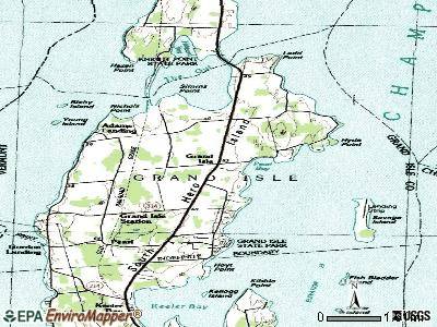
Notable locations in Grand Isle: Maycrest Camp (A), Grand Isle Ferry (B), Wilcox Cove Golf Course (C), Tudhopes Sailing Center (D), Camp Merrycrest (E), Grand Isle Library (F), Grand Isle Fire Department (G), Grand Isle Rescue Building (H). Display/hide their locations on the map
Churches in Grand Isle include: The Lady Chapel (A), Saint Josephs Church (B). Display/hide their locations on the map
Cemeteries: Grand Isle Cemetery (1), Hoag Cemetery (2), Quaker and Macomber Cemetery (3). Display/hide their locations on the map
Swamps: Pearl Swamp (A). Display/hide its location on the map
Park in Grand Isle: Grand Isle State Park (1). Display/hide its location on the map
Hotel: By the Lake Motel (Lakeshore Boulevard) (1). Display/hide its approximate location on the map
Drinking water stations with addresses in Grand Isle and their reported violations in the past:
GRAND ISLE CONSOLIDATED WATER DISTRICT (Population served: 1,493, Surface water):Past health violations:GRAND ISLE FIRE DISTRICT 4 (Population served: 1,063, Surface water):Past monitoring violations:
- MCL, Average - Between JAN-2012 and MAR-2012, Contaminant: Total Haloacetic Acids (HAA5). Follow-up actions: St Public Notif requested (MAY-24-2012), St Formal NOV issued (MAY-24-2012), St Tech Assistance Visit (MAY-24-2012), St Public Notif received (JUL-02-2012), St Compliance achieved (MAY-17-2013)
- MCL, Average - Between OCT-2011 and DEC-2011, Contaminant: Total Haloacetic Acids (HAA5). Follow-up actions: St Public Notif received (DEC-09-2011), St Public Notif requested (MAR-15-2012), St Formal NOV issued (MAR-15-2012), St Tech Assistance Visit (MAR-15-2012), St Compliance achieved (MAY-17-2013)
- MCL, Average - Between JUL-2011 and SEP-2011, Contaminant: Total Haloacetic Acids (HAA5). Follow-up actions: St Public Notif received (DEC-09-2011), St Public Notif requested (JAN-27-2012), St Formal NOV issued (JAN-27-2012), St Tech Assistance Visit (JAN-27-2012), St Compliance achieved (MAY-17-2013)
- MCL, Average - Between JUL-2009 and SEP-2009, Contaminant: Total Haloacetic Acids (HAA5). Follow-up actions: St Tech Assistance Visit (OCT-14-2009), St Public Notif requested (OCT-14-2009), St Formal NOV issued (OCT-14-2009), St Compliance achieved (JUL-16-2010)
- MCL, Average - Between APR-2009 and JUN-2009, Contaminant: Total Haloacetic Acids (HAA5). Follow-up actions: St Formal NOV issued (JUL-16-2009), St Tech Assistance Visit (JUL-16-2009), St Public Notif requested (JUL-16-2009), St Public Notif received (SEP-03-2009), St Compliance achieved (2 times from JUL-16-2010 to JUL-16-2010)
- MCL, Average - Between JAN-2009 and MAR-2009, Contaminant: Total Haloacetic Acids (HAA5). Follow-up actions: St Public Notif received (FEB-10-2009), St Public Notif requested (APR-30-2009), St Tech Assistance Visit (APR-30-2009), St Formal NOV issued (APR-30-2009), St Public Notif received (MAY-21-2009), St Compliance achieved (2 times from JUL-16-2010 to JUL-16-2010)
- 5 other older health violations
- One routine major monitoring violation
Past monitoring violations:
- Follow-up Or Routine LCR Tap M/R - In OCT-01-2008, Contaminant: Lead and Copper Rule. Follow-up actions: St Tech Assistance Visit (DEC-08-2008), St Public Notif requested (DEC-08-2008), St Other (DEC-08-2008), St Formal NOV issued (DEC-08-2008), St Compliance achieved (DEC-12-2008)
- One routine major monitoring violation
| This town: | 2.4 people |
| Vermont: | 2.3 people |
| This town: | 72.1% |
| Whole state: | 62.5% |
| This town: | 8.5% |
| Whole state: | 9.2% |
Likely homosexual households (counted as self-reported same-sex unmarried-partner households)
- Lesbian couples: 1.2% of all households
- Gay men: 0.4% of all households
| This town: | 4.2% |
| Whole state: | 9.4% |
| This town: | 1.8% |
| Whole state: | 3.6% |
For population 15 years and over in Grand Isle:
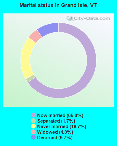
- Never married: 18.7%
- Now married: 65.0%
- Separated: 1.7%
- Widowed: 4.8%
- Divorced: 9.7%
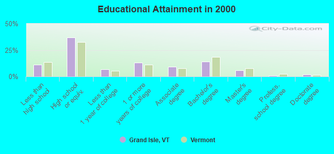
For population 25 years and over in Grand Isle:
- High school or higher: 89.0%
- Bachelor's degree or higher: 22.7%
- Graduate or professional degree: 8.8%
- Unemployed: 2.3%
- Mean travel time to work (commute): 32.9 minutes
| Here: | 10.7 |
| Vermont average: | 11.7 |
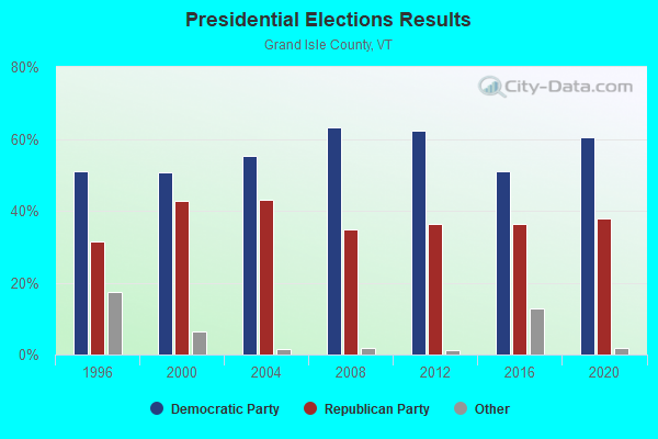
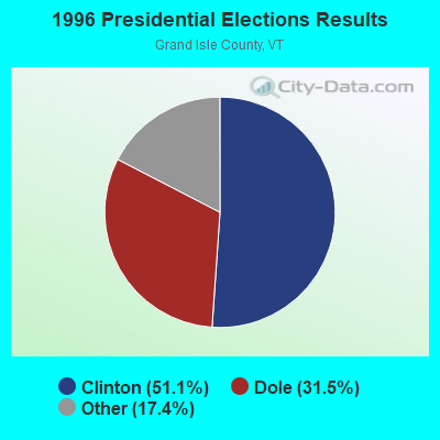
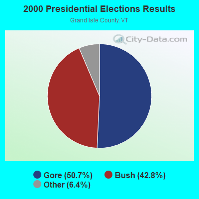
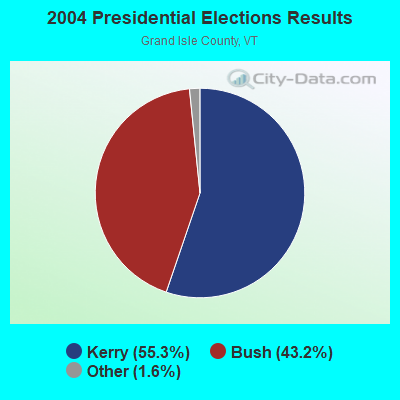
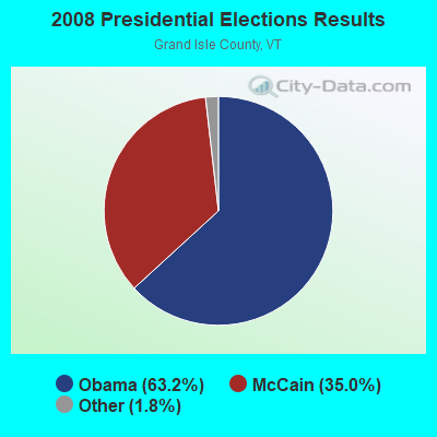
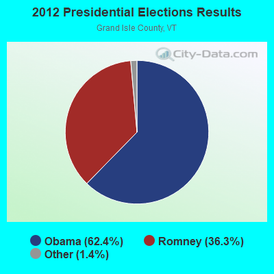


Graphs represent county-level data. Detailed 2008 Election Results
Religion statistics for Grand Isle, VT (based on Grand Isle County data)
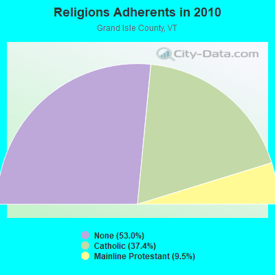
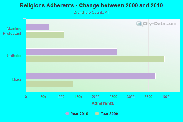
| Religion | Adherents | Congregations |
|---|---|---|
| Catholic | 2,609 | 5 |
| Mainline Protestant | 665 | 5 |
| Other | 1 | - |
| None | 3,695 | - |
Food Environment Statistics:
| Grand Isle County: | 3.96 / 10,000 pop. |
| Vermont: | 3.84 / 10,000 pop. |
| Grand Isle County: | 1.32 / 10,000 pop. |
| State: | 1.95 / 10,000 pop. |
| Grand Isle County: | 10.55 / 10,000 pop. |
| State: | 6.40 / 10,000 pop. |
| This county: | 5.27 / 10,000 pop. |
| State: | 11.52 / 10,000 pop. |
| This county: | 5.8% |
| Vermont: | 6.8% |
| Here: | 25.2% |
| Vermont: | 22.3% |
| Here: | 16.3% |
| Vermont: | 13.3% |
Strongest AM radio stations in Grand Isle:
- WCHP (760 AM; 35 kW; CHAMPLAIN, NY; Owner: CHAMPLAIN RADIO, INC.)
- WVMT (620 AM; 5 kW; BURLINGTON, VT; Owner: SISON BROADCASTING, INC.)
- WTWK (1070 AM; daytime; 5 kW; PLATTSBURGH, NY; Owner: CHAMPLAIN COMMUNICATIONS CORPORATION)
- WEAV (960 AM; 5 kW; PLATTSBURGH, NY; Owner: CLEAR CHANNEL BROADCASTING LICENSES, INC.)
- WICY (1490 AM; 50 kW; MALONE, NY; Owner: CARTIER COMMUNICATIONS INC.)
- WVAA (1390 AM; 5 kW; BURLINGTON, VT; Owner: RADIO VERMONT, KDR, LLC)
- WIRY (1340 AM; 1 kW; PLATTSBURGH, NY; Owner: HOMETOWN RADIO INC)
- WDEV (550 AM; 5 kW; WATERBURY, VT; Owner: RADIO VERMONT, INC.)
- WRSA (1420 AM; 1 kW; ST. ALBANS, VT)
- WGY (810 AM; 50 kW; SCHENECTADY, NY; Owner: CLEAR CHANNEL BROADCASTING LICENSES, INC.)
- WIRD (920 AM; 5 kW; LAKE PLACID, NY; Owner: RADIO LAKE PLACID INC)
- WNNZ (640 AM; 50 kW; WESTFIELD, MA; Owner: CLEAR CHANNEL BROADCASTING LICENSES, INC.)
- WJOY (1230 AM; 1 kW; BURLINGTON, VT; Owner: HALL COMMUNICATIONS, INC.)
Strongest FM radio stations in Grand Isle:
- WCEL (91.9 FM; PLATTSBURGH, NY; Owner: WAMC)
- WEZF (92.9 FM; BURLINGTON, VT; Owner: CAPSTAR TX LIMITED PARTNERSHIP)
- WVPS (107.9 FM; BURLINGTON, VT; Owner: VERMONT PUBLIC RADIO)
- WLKC (103.3 FM; WATERBURY, VT; Owner: RADIO BROADCASTING SERVICES, INC.)
- WLFE-FM (102.3 FM; ST. ALBANS, VT; Owner: CHAMPLAIN COMMUNICATIONS CORP.)
- WCVT (101.7 FM; STOWE, VT; Owner: RADIO VERMONT CLASSICS, L.L.C.)
- WBTZ (99.9 FM; PLATTSBURGH, NY; Owner: PLATTSBURGH BROADCASTING CORPORATION)
- WNCS (104.7 FM; MONTPELIER, VT; Owner: MONTPELIER BROADCASTING, INC.)
- WXLU (88.3 FM; PERU, NY; Owner: THE ST. LAWRENCE UNIVERSITY)
- WCPV (101.3 FM; ESSEX, NY; Owner: CAPSTAR TX LIMITED PARTNERSHIP)
- WDEV-FM (96.1 FM; WARREN, VT; Owner: RADIO VERMONT, INC.)
- WYUL (94.7 FM; CHATEAUGAY, NY; Owner: CARTIER COMMUNICATIONS INC.)
- WGLY-FM (91.5 FM; BOLTON, VT; Owner: CHRISTIAN MINISTRIES, INC.)
- WXZO (96.7 FM; WILLSBORO, NY; Owner: CAPSTAR TX LIMITED PARTNERSHIP)
- WIZN (106.7 FM; VERGENNES, VT; Owner: BURLINGTON BROADCASTERS, INC.)
- WKOL (105.1 FM; PLATTSBURGH, NY; Owner: HALL COMMUNICATIONS, INC.)
- WXXX (95.5 FM; SOUTH BURLINGTON, VT; Owner: SISON BROADCASTING, INC.)
- WOKO (98.9 FM; BURLINGTON, VT; Owner: HALL COMMUNICATIONS, INC.)
- W207AX (89.3 FM; BURLINGTON, VT; Owner: FAMILY STATIONS, INC.)
- W206AQ (89.1 FM; PLATTSBURGH, NY; Owner: EDUCATIONAL MEDIA FOUNDATION)
TV broadcast stations around Grand Isle:
- WPTZ (Channel 5; NORTH POLE, NY; Owner: HEARST-ARGYLE STATIONS, INC.)
- W16AL (Channel 16; BURLINGTON, VT; Owner: TRINITY BROADCASTING NETWORK)
- WCFE-TV (Channel 57; PLATTSBURGH, NY; Owner: MOUNTAIN LAKE PUBLIC TELEVISION COUNCIL)
Grand Isle fatal accident list:
Apr 29, 2008 01:33 PM, Sr-314, Lat: 44.703050, Lon: -73.305530, Vehicles: 1, Persons: 1, Fatalities: 1
Aug 14, 2000 08:34 PM, Us-2, Vehicles: 2, Persons: 2, Fatalities: 1, Drunk persons involved: 1
Dec 21, 2000 08:20 AM, Us-2, Vehicles: 2, Persons: 2, Fatalities: 1
Aug 16, 1999 10:32 PM, Us-2, Vehicles: 3, Persons: 6, Fatalities: 2, Drunk persons involved: 1
Oct 11, 1998 09:30 AM, Us-2, Vehicles: 1, Persons: 1, Fatalities: 1
Jan 24, 1992 02:05 PM, Us2, Vehicles: 1, Persons: 1, Fatalities: 1
FCC Registered Antenna Towers:
3- Michael Wilson, 10 Island Circle (Lat: 44.704389 Lon: -73.301611), Type: 56.1, Structure height: 50013 m, Overall height: 54.9 m, Registrant: Parailel Towers Iii, LLC, Michael.Wilson@pitowers.Com, , Charl-otte, Phone: (904) 452-4889
- Michael Wilson, 10 Island Circle (Lat: 44.704389 Lon: -73.301611), Type: 56.1, Structure height: 50013 m, Overall height: 54.9 m, Registrant: Parailel Infrastructure Iii, LLC, Michael.Wilson@pitowers.Com, , Charl-otte, Phone: (904) 452-4889
- Michael Wilson, 10 Island Circle (Lat: 44.704389 Lon: -73.301611), Type: 56.1, Structure height: 50013 m, Overall height: 54.9 m, Registrant: Parailel Infrastructure Iii, LLC, Michael.Wilson@pitowers.Com, , Charl-otte, Phone: (904) 452-4889
FCC Registered Microwave Towers:
3- VTGI5a-Lovers Lane, 37 Lovers Lane (Lat: 44.737306 Lon: -73.274500), Type: Tank, Structure height: 30.5 m, Overall height: 31.7 m, Call Sign: WQJL766,
Assigned Frequencies: 10815.0 MHz, Grant Date: 10/27/2008, Expiration Date: 10/27/2018, Cancellation Date: 04/20/2010, Certifier: Shirley J Linn, Registrant: Latham & Watkins LLP, 555 Eleventh Street, Nw, Suite 1000, Washington, DC 20004-1304, Phone: (202) 637-2200, Fax: (202) 637-2201, Email:
- VTGI2a-Hatchery Towe, 3 Fish Hatchery Rd (Lat: 44.692167 Lon: -73.338750), Type: Tank, Structure height: 30.5 m, Overall height: 33.5 m, Call Sign: WQJL769,
Assigned Frequencies: 10735.0 MHz, 10855.0 MHz, Grant Date: 10/27/2008, Expiration Date: 10/27/2018, Cancellation Date: 04/20/2010, Certifier: Shirley J Linn, Registrant: Latham & Watkins LLP, 555 Eleventh Street, Nw, Suite 1000, Washington, DC 20004-1304, Phone: (202) 637-2200, Fax: (202) 637-2201, Email:
- VTGI1b-Main, 167 Us Route 2 (Lat: 44.713722 Lon: -73.298722), Type: Silo, Structure height: 25.6 m, Call Sign: WQJM264,
Assigned Frequencies: 11225.0 MHz, 11305.0 MHz, Grant Date: 10/30/2008, Expiration Date: 10/30/2018, Cancellation Date: 04/20/2010, Certifier: Shirley J Linn, Registrant: Latham & Watkins LLP, 555 Eleventh Street, Nw, Suite 1000, Washington, DC 20004-1304, Phone: (202) 637-2200, Fax: (202) 637-2201, Email:
FCC Registered Maritime Coast & Aviation Ground Towers:
2- Gordon Landing Ferry Dock (Lat: 44.688667 Lon: -73.349861), Type: Building, Overall height: 4 m, Call Sign: WHX252,
Assigned Frequencies: 156.350 MHz, 156.475 MHz, 156.450 MHz, 156.800 MHz, Grant Date: 02/22/2023, Expiration Date: 04/19/2033, Registrant: Lake Champlain Transportation Company, 1 King Street Sock, Burlington, VT 05401, Phone: (802) 864-9804, Email:
- Lat: 44.687778 Lon: -73.348889, Call Sign: WQUP459,
Assigned Frequencies: 156.175 MHz, 156.800 MHz, Grant Date: 09/03/2014, Expiration Date: 09/03/2024, Certifier: Heather A Stewart Mrs, Registrant: Lake Champlain Transportation Company, 1 King Street Dock, Burlington, VT 05401, Phone: (802) 864-9804, Fax: (802) 864-6830, Email:
FCC Registered Amateur Radio Licenses:
17 (See the full list of FCC Registered Amateur Radio Licenses in Grand Isle)FAA Registered Aircraft:
4- Aircraft: PIPER PA-39 (Category: Land, Engines: 2, Seats: 6, Weight: Up to 12,499 Pounds, Speed: 183 mph), Engine: LYCOMING 0-290 SERIES (140 HP) (Reciprocating)
N-Number: 289WW, N289WW, N-289WW, Serial Number: 39-84, Year manufactured: 1971, Airworthiness Date: 03/03/1971, Certificate Issue Date: 10/28/2020
Registrant (Individual): Michael D Sturges, 126 E Shore S, Grand Isle, VT 05458 - Aircraft: PIPER PA-24-260 (Category: Land, Seats: 4, Weight: Up to 12,499 Pounds, Speed: 135 mph), Engine: LYCOMING TI0-540 SER (310 HP) (Reciprocating)
N-Number: 8663P, N8663P, N-8663P, Serial Number: 24-4110, Year manufactured: 1965, Airworthiness Date: 01/14/1965, Certificate Issue Date: 06/27/2011
Registrant (Individual): Michael E Placke, 6 Ladd Pt, Grand Isle, VT 05458 - Aircraft: CONSOLIDATED AERONAUTICS INC. LAKE LA-4 (Category: Land, Seats: 4, Weight: Up to 12,499 Pounds, Speed: 112 mph), Engine: LYCOMING O-360-A1A (180 HP) (Reciprocating)
N-Number: 964LA, N964LA, N-964LA, Serial Number: 286, Year manufactured: 1964, Airworthiness Date: 08/08/2009, Certificate Issue Date: 07/24/2009
Registrant (Individual): Robert M Sr Harriman, 319 Us Route 2, Grand Isle, VT 05458 - Aircraft: LET KUNOVICE Z-37 A2 (Category: Land, Seats: 2, Weight: Up to 12,499 Pounds), Engine: AMA/EXPR UNKNOWN ENG (Reciprocating)
N-Number: 42921, N42921, N-42921, Serial Number: 09-29, Year manufactured: 1974, Airworthiness Date: 01/28/1999, Certificate Issue Date: 12/20/2004
Registrant (Co-Owned): Jeffrey W Bryant, 28 Pearl St, Grand Isle, VT 05458, Other Owners: Gary W Bryant
Deregistered: Cancel Date: 01/19/2018
2002 - 2018 National Fire Incident Reporting System (NFIRS) incidents
- Fire incident types reported to NFIRS in Grand Isle, VT
- 5150.0%Structure Fires
- 3231.4%Outside Fires
- 1110.8%Other
- 87.8%Mobile Property/Vehicle Fires
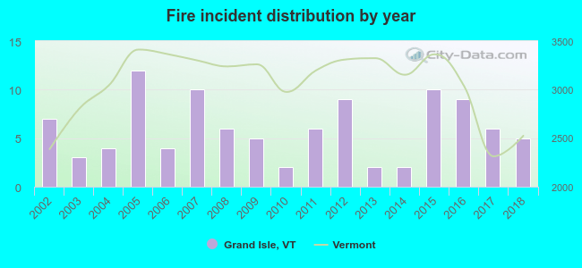 Based on the data from the years 2002 - 2018 the average number of fire incidents per year is 6. The highest number of reported fires - 12 took place in 2005, and the least - 2 in 2010. The data has a decreasing trend.
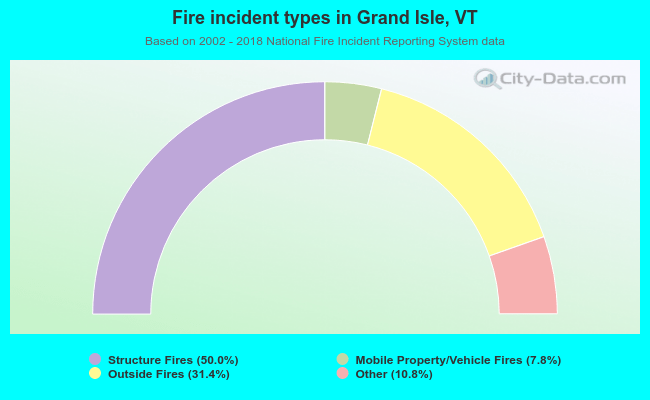 When looking into fire subcategories, the most reports belonged to: Structure Fires (50.0%), and Outside Fires (31.4%).
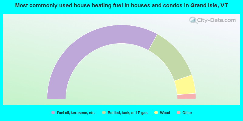
- 66.1%Fuel oil, kerosene, etc.
- 23.5%Bottled, tank, or LP gas
- 8.1%Wood
- 1.7%Electricity
- 0.3%Utility gas
- 0.3%Other fuel
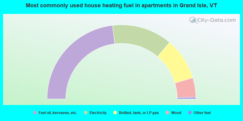
- 46.1%Fuel oil, kerosene, etc.
- 26.2%Electricity
- 18.4%Bottled, tank, or LP gas
- 8.5%Wood
- 0.7%Other fuel
Grand Isle compared to Vermont state average:
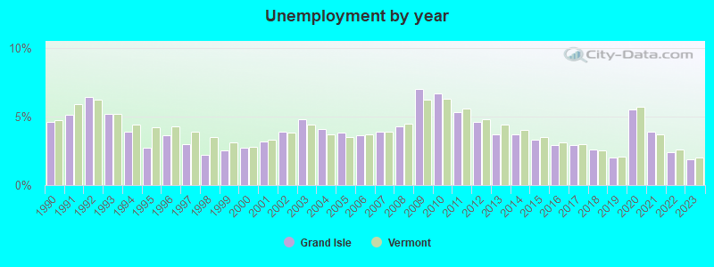
- Unemployed percentage significantly below state average.
- Black race population percentage below state average.
- Hispanic race population percentage below state average.
- Length of stay since moving in significantly above state average.
- Number of rooms per house significantly below state average.
- House age significantly below state average.

|
|
Total of 158 patent applications in 2008-2024.