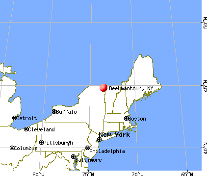
Beekmantown, New York
Submit your own pictures of this town and show them to the world
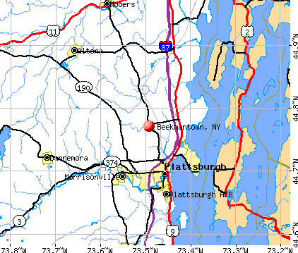
- OSM Map
- General Map
- Google Map
- MSN Map
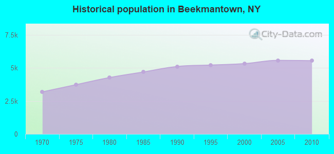
Population change since 2000: +4.1%
 |
| Males: 2,766 | |
| Females: 2,779 |
| Median resident age: | 42.9 years |
| New York median age: | 40.7 years |
Zip codes: 12992.
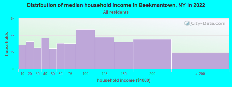
| Beekmantown: | $76,026 |
| NY: | $79,557 |
Estimated per capita income in 2022: $36,826 (it was $18,792 in 2000)
Beekmantown town income, earnings, and wages data
Estimated median house or condo value in 2022: $196,022 (it was $82,100 in 2000)
| Beekmantown: | $196,022 |
| NY: | $400,400 |
Mean prices in 2022: all housing units: $199,088; detached houses: $212,279; townhouses or other attached units: $165,284; in 2-unit structures: $545,537; in 3-to-4-unit structures: $216,109; in 5-or-more-unit structures: $548,924; mobile homes: $82,996
Detailed information about poverty and poor residents in Beekmantown, NY


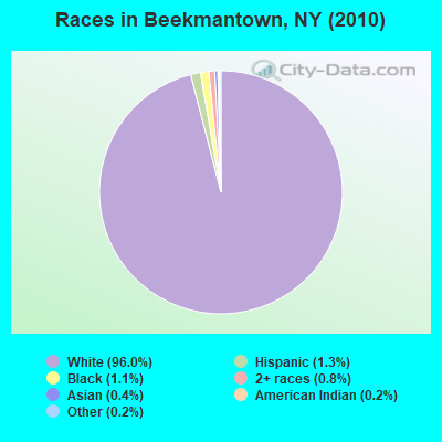
- 5,32596.0%White alone
- 731.3%Hispanic
- 631.1%Black alone
- 430.8%Two or more races
- 210.4%Asian alone
- 110.2%American Indian alone
- 90.2%Other race alone
Races in Beekmantown detailed stats: ancestries, foreign born residents, place of birth
 Recent articles from our blog. Our writers, many of them Ph.D. graduates or candidates, create easy-to-read articles on a wide variety of topics.

 | smaller Upstate NY cities and towns/African American communities (5974 replies) |
| Girls flag football officially comes to New York State (298 replies) |
| Asian communities in Upstate NY (596 replies) |
| Affluent Upstate NY... (139 replies) |
| Graduation videos… (38 replies) |
| Downstate counties have highest rates of students in private schools. Check your district (3 replies) |
Latest news from Beekmantown, NY collected exclusively by city-data.com from local newspapers, TV, and radio stations
Ancestries: French (24.8%), French Canadian (12.8%), Irish (12.6%), United States (11.3%), English (8.9%), German (5.8%).
Current Local Time: EST time zone
Land area: 60.5 square miles.
Population density: 92 people per square mile (very low).
108 residents are foreign born (1.1% North America, 0.6% Asia, 0.2% Europe).
| This town: | 2.0% |
| New York: | 20.4% |
| Beekmantown town: | 1.7% ($1,412) |
| New York: | 1.9% ($2,847) |
Nearest city with pop. 50,000+: Schenectady, NY  (137.7 miles , pop. 61,821).
Nearest city with pop. 200,000+: Boston, MA (208.1 miles , pop. 589,141).
Nearest city with pop. 1,000,000+: Bronx, NY (272.1 miles , pop. 1,332,650).
Nearest cities:
), ), ), ), )Latitude: 44.77 N, Longitude: 73.50 W
Area code commonly used in this area: 518

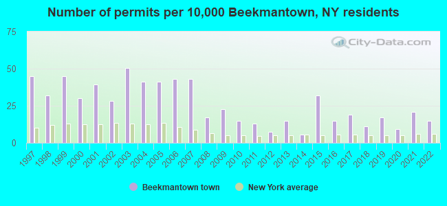
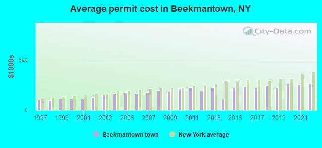
Single-family new house construction building permits:
- 2022: 8 buildings, average cost: $259,400
- 2021: 11 buildings, average cost: $255,000
- 2020: 5 buildings, average cost: $259,000
- 2019: 9 buildings, average cost: $218,300
- 2018: 6 buildings, average cost: $241,700
- 2017: 10 buildings, average cost: $220,500
- 2016: 8 buildings, average cost: $235,000
- 2015: 17 buildings, average cost: $217,600
- 2014: 3 buildings, average cost: $112,700
- 2013: 8 buildings, average cost: $218,800
- 2012: 4 buildings, average cost: $190,000
- 2011: 7 buildings, average cost: $222,900
- 2010: 8 buildings, average cost: $215,600
- 2009: 12 buildings, average cost: $182,500
- 2008: 9 buildings, average cost: $195,000
- 2007: 23 buildings, average cost: $173,500
- 2006: 23 buildings, average cost: $166,500
- 2005: 22 buildings, average cost: $178,200
- 2004: 22 buildings, average cost: $167,000
- 2003: 27 buildings, average cost: $153,000
- 2002: 15 buildings, average cost: $126,700
- 2001: 21 buildings, average cost: $110,500
- 2000: 16 buildings, average cost: $111,300
- 1999: 24 buildings, average cost: $114,000
- 1998: 17 buildings, average cost: $97,100
- 1997: 24 buildings, average cost: $101,700
| Here: | 4.0% |
| New York: | 4.4% |
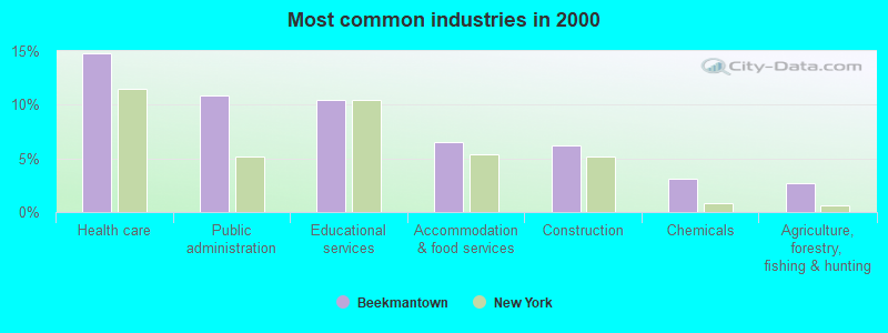
- Health care (14.8%)
- Public administration (10.9%)
- Educational services (10.5%)
- Accommodation & food services (6.5%)
- Construction (6.3%)
- Chemicals (3.1%)
- Agriculture, forestry, fishing & hunting (2.7%)
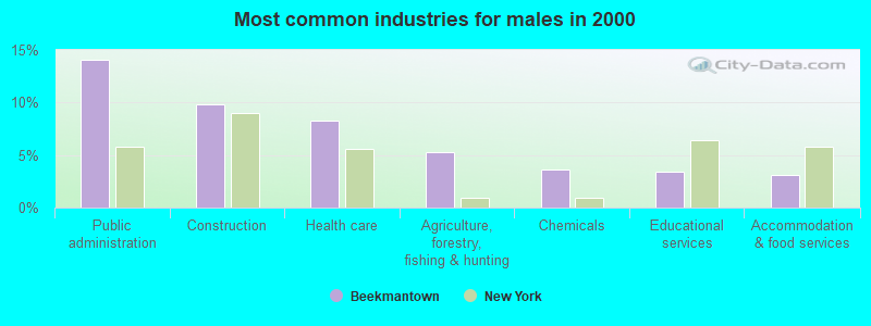
- Public administration (14.1%)
- Construction (9.8%)
- Health care (8.3%)
- Agriculture, forestry, fishing & hunting (5.3%)
- Chemicals (3.6%)
- Educational services (3.5%)
- Accommodation & food services (3.2%)
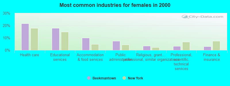
- Health care (21.7%)
- Educational services (17.9%)
- Accommodation & food services (10.0%)
- Public administration (7.5%)
- Religious, grantmaking, civic, professional, similar organizations (3.4%)
- Professional, scientific, technical services (3.3%)
- Finance & insurance (2.9%)
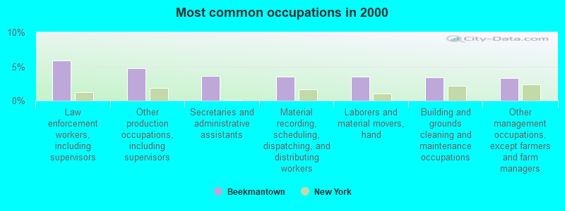
- Law enforcement workers, including supervisors (5.9%)
- Other production occupations, including supervisors (4.8%)
- Secretaries and administrative assistants (3.6%)
- Material recording, scheduling, dispatching, and distributing workers (3.6%)
- Laborers and material movers, hand (3.5%)
- Building and grounds cleaning and maintenance occupations (3.4%)
- Other management occupations, except farmers and farm managers (3.3%)
- Law enforcement workers, including supervisors (10.1%)
- Laborers and material movers, hand (5.9%)
- Driver/sales workers and truck drivers (5.6%)
- Other production occupations, including supervisors (5.5%)
- Electrical equipment mechanics and other installation, maintenance, and repair workers, including supervisors (5.4%)
- Other management occupations, except farmers and farm managers (3.8%)
- Agricultural workers, including supervisors (3.4%)
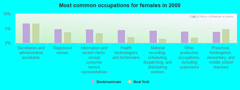
- Secretaries and administrative assistants (6.8%)
- Registered nurses (4.9%)
- Information and record clerks, except customer service representatives (4.8%)
- Health technologists and technicians (4.5%)
- Material recording, scheduling, dispatching, and distributing workers (4.4%)
- Other production occupations, including supervisors (4.0%)
- Preschool, kindergarten, elementary, and middle school teachers (3.9%)
Average climate in Beekmantown, New York
Based on data reported by over 4,000 weather stations


(lower is better)
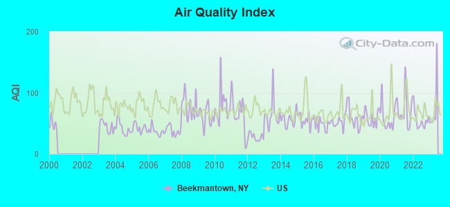
Air Quality Index (AQI) level in 2022 was 55.1. This is better than average.
| City: | 55.1 |
| U.S.: | 72.6 |
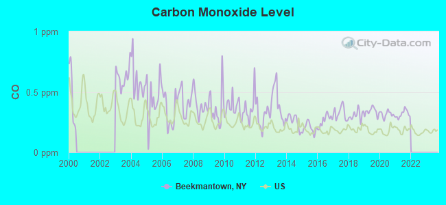
Carbon Monoxide (CO) [ppm] level in 2021 was 0.317. This is worse than average. Closest monitor was 24.7 miles away from the city center.
| City: | 0.317 |
| U.S.: | 0.251 |
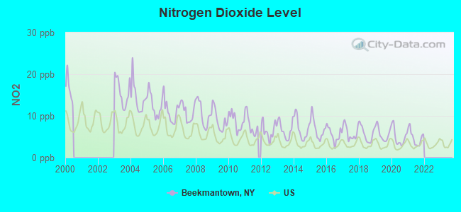
Nitrogen Dioxide (NO2) [ppb] level in 2021 was 4.81. This is about average. Closest monitor was 24.7 miles away from the city center.
| City: | 4.81 |
| U.S.: | 5.11 |
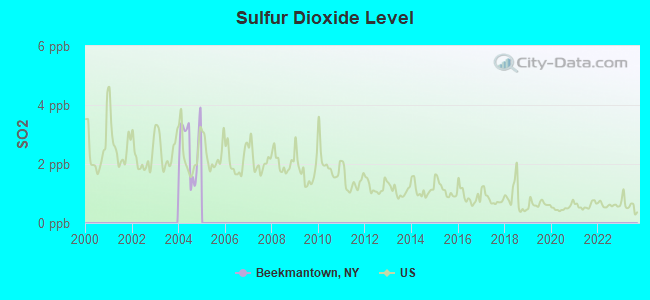
Sulfur Dioxide (SO2) [ppb] level in 2004 was 2.59. This is significantly worse than average. Closest monitor was 24.9 miles away from the city center.
| City: | 2.59 |
| U.S.: | 1.51 |
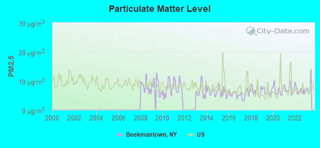
Particulate Matter (PM2.5) [µg/m3] level in 2022 was 6.79. This is about average. Closest monitor was 24.5 miles away from the city center.
| City: | 6.79 |
| U.S.: | 8.11 |
Earthquake activity:
Beekmantown-area historical earthquake activity is above New York state average. It is 76% smaller than the overall U.S. average.On 4/20/2002 at 10:50:47, a magnitude 5.3 (5.3 ML, Depth: 3.0 mi, Class: Moderate, Intensity: VI - VII) earthquake occurred 20.4 miles away from the city center
On 4/20/2002 at 10:50:47, a magnitude 5.2 (5.2 MB, 4.2 MS, 5.2 MW, 5.0 MW) earthquake occurred 22.4 miles away from Beekmantown center
On 10/7/1983 at 10:18:46, a magnitude 5.3 (5.1 MB, 5.3 LG, 5.1 ML) earthquake occurred 70.3 miles away from the city center
On 1/19/1982 at 00:14:42, a magnitude 4.7 (4.5 MB, 4.7 MD, 4.5 LG, Class: Light, Intensity: IV - V) earthquake occurred 128.9 miles away from the city center
On 10/16/2012 at 23:12:25, a magnitude 4.7 (4.7 ML, Depth: 10.0 mi) earthquake occurred 162.7 miles away from Beekmantown center
On 4/20/2002 at 11:04:42, a magnitude 3.7 (3.7 ML, Depth: 3.1 mi, Class: Light, Intensity: II - III) earthquake occurred 21.6 miles away from Beekmantown center
Magnitude types: regional Lg-wave magnitude (LG), body-wave magnitude (MB), duration magnitude (MD), local magnitude (ML), surface-wave magnitude (MS), moment magnitude (MW)
Natural disasters:
The number of natural disasters in Clinton County (15) is near the US average (15).Major Disasters (Presidential) Declared: 9
Emergencies Declared: 5
Causes of natural disasters: Floods: 5, Storms: 5, Hurricanes: 3, Winter Storms: 2, Blizzard: 1, Earthquake: 1, Power Outage: 1, Snowstorm: 1, Tornado: 1, Wind: 1, Other: 2 (Note: some incidents may be assigned to more than one category).
Hospitals and medical centers near Beekmantown:
- CVPH MEDICAL CENTER RENAL CENTER (Dialysis Facility, about 6 miles away; PLATTSBURGH, NY)
- CHAMPLAIN VALLEY PHYSICIANS HOSPITAL MEDICAL CTR Acute Care Hospitals (about 6 miles away; PLATTSBURGH, NY)
- MEADOWBROOK HEALTHCARE (Nursing Home, about 6 miles away; PLATTSBURGH, NY)
- CLINTON CO DEPT HEALTH CHHA (Home Health Center, about 6 miles away; PLATTSBURGH, NY)
- HOSPICE OF THE NORTH COUNTRY INC (Hospital, about 6 miles away; PLATTSBURGH, NY)
- EVERGREEN VALLEY NURSING HOME (Nursing Home, about 7 miles away; PLATTSBURGH, NY)
- CLINTON COUNTY NURSING HOME (Nursing Home, about 7 miles away; PLATTSBURGH, NY)
Airports and other landing facilities located in Beekmantown:
See details about Airports and other landing facilities located in Beekmantown, NYAmtrak stations near Beekmantown:
- 6 miles: PLATTSBURGH (BRIDGE ST.) . Services: enclosed waiting area, public restrooms, public payphones, free short-term parking, free long-term parking, call for car rental service, call for taxi service.
- 14 miles: PORT KENT (RTE. 9 NORTH) - Seasonal Station . Services: free short-term parking, call for taxi service.
- 17 miles: ROUSES POINT (PRATT ST.) . Services: enclosed waiting area, public restrooms, public payphones, free short-term parking, free long-term parking, call for car rental service, call for taxi service.
Colleges/universities with over 2000 students nearest to Beekmantown:
- SUNY College at Plattsburgh (about 6 miles; Plattsburgh, NY; Full-time enrollment: 5,934)
- Community College of Vermont (about 25 miles; Winooski, VT; FT enrollment: 3,394)
- University of Vermont (about 26 miles; Burlington, VT; FT enrollment: 11,566)
- Champlain College (about 26 miles; Burlington, VT; FT enrollment: 2,623)
- Saint Michael's College (about 26 miles; Colchester, VT; FT enrollment: 2,336)
- Middlebury College (about 56 miles; Middlebury, VT; FT enrollment: 3,077)
- Norwich University (about 61 miles; Northfield, VT; FT enrollment: 4,221)
Points of interest:
Notable locations in Beekmantown: Mooney Bay Marina (A), Point Au Roche Light (B), Saint Armand Beach (C), Country Dreams Farm (D), Beekmantown Southbound Rest Area (E), Beekmantown Northbound Rest Area (F), Beekman Lane Farms (G), Clearfield Farm (H), Carter Farms (I), Bubbins Farm (J), Castine Farms (K). Display/hide their locations on the map
Cemeteries: Point An Roche Cemetery (1), Point Comfort (2). Display/hide their locations on the map
Lake: Duncan Pond (A). Display/hide its location on the map
Streams, rivers, and creeks: Rea Brook (A), Riley Brook (B). Display/hide their locations on the map
| This town: | 2.5 people |
| New York: | 2.6 people |
| This town: | 71.1% |
| Whole state: | 63.5% |
| This town: | 10.3% |
| Whole state: | 6.8% |
Likely homosexual households (counted as self-reported same-sex unmarried-partner households)
- Lesbian couples: 0.2% of all households
- Gay men: 0.4% of all households
| This town: | 12.9% |
| Whole state: | 14.6% |
| This town: | 6.9% |
| Whole state: | 7.4% |
For population 15 years and over in Beekmantown:
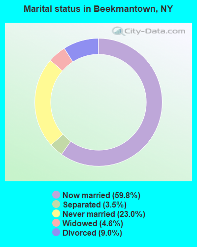
- Never married: 23.0%
- Now married: 59.8%
- Separated: 3.5%
- Widowed: 4.6%
- Divorced: 9.0%
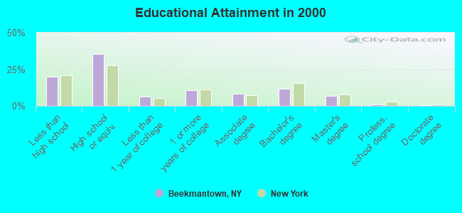
For population 25 years and over in Beekmantown:
- High school or higher: 80.0%
- Bachelor's degree or higher: 20.0%
- Graduate or professional degree: 8.4%
- Unemployed: 8.6%
- Mean travel time to work (commute): 20.4 minutes
| Here: | 11.7 |
| New York average: | 14.2 |
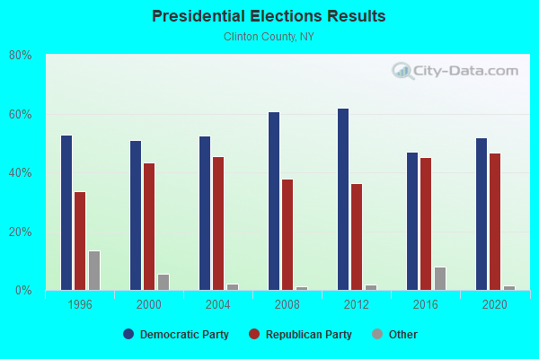
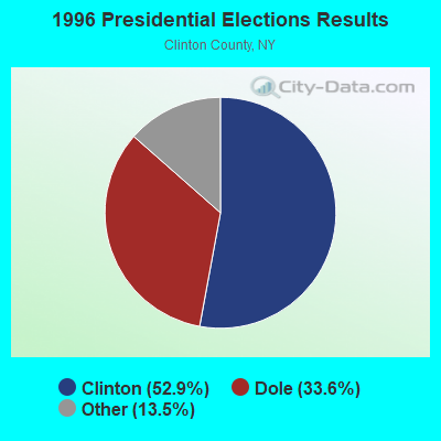
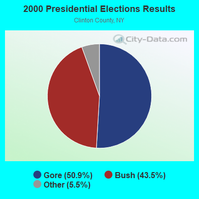
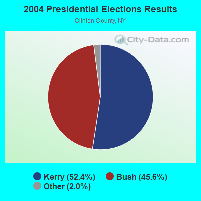
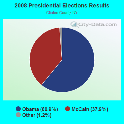
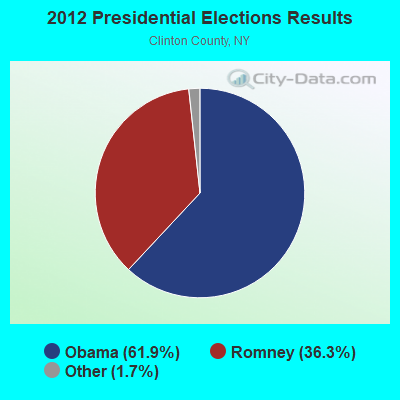
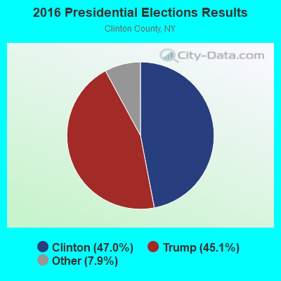
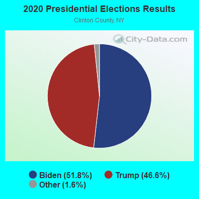
Graphs represent county-level data. Detailed 2008 Election Results
Religion statistics for Beekmantown, NY (based on Clinton County data)
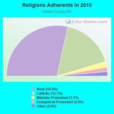
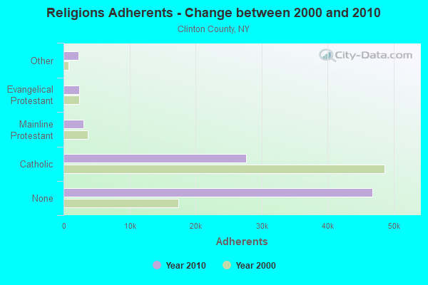
| Religion | Adherents | Congregations |
|---|---|---|
| Catholic | 27,695 | 31 |
| Mainline Protestant | 3,038 | 21 |
| Evangelical Protestant | 2,417 | 21 |
| Other | 2,266 | 7 |
| None | 46,712 | - |
Food Environment Statistics:
| This county: | 2.92 / 10,000 pop. |
| New York: | 4.13 / 10,000 pop. |
| Clinton County: | 0.12 / 10,000 pop. |
| New York: | 0.06 / 10,000 pop. |
| Clinton County: | 0.61 / 10,000 pop. |
| State: | 0.92 / 10,000 pop. |
| Clinton County: | 6.21 / 10,000 pop. |
| New York: | 1.68 / 10,000 pop. |
| Clinton County: | 8.90 / 10,000 pop. |
| New York: | 8.82 / 10,000 pop. |
| Clinton County: | 7.3% |
| New York: | 8.2% |
| Here: | 25.4% |
| State: | 23.8% |
| Clinton County: | 13.4% |
| New York: | 15.6% |
Strongest AM radio stations in Beekmantown:
- WCHP (760 AM; 35 kW; CHAMPLAIN, NY; Owner: CHAMPLAIN RADIO, INC.)
- WTWK (1070 AM; daytime; 5 kW; PLATTSBURGH, NY; Owner: CHAMPLAIN COMMUNICATIONS CORPORATION)
- WIRY (1340 AM; 1 kW; PLATTSBURGH, NY; Owner: HOMETOWN RADIO INC)
- WICY (1490 AM; 50 kW; MALONE, NY; Owner: CARTIER COMMUNICATIONS INC.)
- WEAV (960 AM; 5 kW; PLATTSBURGH, NY; Owner: CLEAR CHANNEL BROADCASTING LICENSES, INC.)
- WVMT (620 AM; 5 kW; BURLINGTON, VT; Owner: SISON BROADCASTING, INC.)
- WVAA (1390 AM; 5 kW; BURLINGTON, VT; Owner: RADIO VERMONT, KDR, LLC)
- WDEV (550 AM; 5 kW; WATERBURY, VT; Owner: RADIO VERMONT, INC.)
- WGY (810 AM; 50 kW; SCHENECTADY, NY; Owner: CLEAR CHANNEL BROADCASTING LICENSES, INC.)
- WIRD (920 AM; 5 kW; LAKE PLACID, NY; Owner: RADIO LAKE PLACID INC)
- WNNZ (640 AM; 50 kW; WESTFIELD, MA; Owner: CLEAR CHANNEL BROADCASTING LICENSES, INC.)
- WRKO (680 AM; 50 kW; BOSTON, MA; Owner: ENTERCOM BOSTON LICENSE, LLC)
- WRSA (1420 AM; 1 kW; ST. ALBANS, VT)
Strongest FM radio stations in Beekmantown:
- WCEL (91.9 FM; PLATTSBURGH, NY; Owner: WAMC)
- WBTZ (99.9 FM; PLATTSBURGH, NY; Owner: PLATTSBURGH BROADCASTING CORPORATION)
- WXLU (88.3 FM; PERU, NY; Owner: THE ST. LAWRENCE UNIVERSITY)
- WEZF (92.9 FM; BURLINGTON, VT; Owner: CAPSTAR TX LIMITED PARTNERSHIP)
- WVPS (107.9 FM; BURLINGTON, VT; Owner: VERMONT PUBLIC RADIO)
- WLKC (103.3 FM; WATERBURY, VT; Owner: RADIO BROADCASTING SERVICES, INC.)
- WCVT (101.7 FM; STOWE, VT; Owner: RADIO VERMONT CLASSICS, L.L.C.)
- WYUL (94.7 FM; CHATEAUGAY, NY; Owner: CARTIER COMMUNICATIONS INC.)
- WNCS (104.7 FM; MONTPELIER, VT; Owner: MONTPELIER BROADCASTING, INC.)
- WLFE-FM (102.3 FM; ST. ALBANS, VT; Owner: CHAMPLAIN COMMUNICATIONS CORP.)
- WDEV-FM (96.1 FM; WARREN, VT; Owner: RADIO VERMONT, INC.)
- WCPV (101.3 FM; ESSEX, NY; Owner: CAPSTAR TX LIMITED PARTNERSHIP)
- WKOL (105.1 FM; PLATTSBURGH, NY; Owner: HALL COMMUNICATIONS, INC.)
- WXZO (96.7 FM; WILLSBORO, NY; Owner: CAPSTAR TX LIMITED PARTNERSHIP)
- WIZN (106.7 FM; VERGENNES, VT; Owner: BURLINGTON BROADCASTERS, INC.)
- WGLY-FM (91.5 FM; BOLTON, VT; Owner: CHRISTIAN MINISTRIES, INC.)
- W206AQ (89.1 FM; PLATTSBURGH, NY; Owner: EDUCATIONAL MEDIA FOUNDATION)
- WQKE (93.9 FM; PLATTSBURGH, NY; Owner: STATE UNIVERSITY OF NEW YORK)
TV broadcast stations around Beekmantown:
- WPTZ (Channel 5; NORTH POLE, NY; Owner: HEARST-ARGYLE STATIONS, INC.)
- WWBI-LP (Channel 27; PLATTSBURGH, NY; Owner: SMC COMMUNICATIONS, INC.)
- WCFE-TV (Channel 57; PLATTSBURGH, NY; Owner: MOUNTAIN LAKE PUBLIC TELEVISION COUNCIL)
- W49BI (Channel 49; ELLENBURG, NY; Owner: PLATTSBURGH PARTNERS)

- National Bridge Inventory (NBI) Statistics
- 6Number of bridges
- 46ft / 14.4mTotal length
- $4,391,000Total costs
- 14,126Total average daily traffic
- 579Total average daily truck traffic
FCC Registered Antenna Towers:
31 (See the full list of FCC Registered Antenna Towers in Beekmantown)FCC Registered Commercial Land Mobile Towers:
1 (See the full list of FCC Registered Commercial Land Mobile Towers in Beekmantown, NY)FCC Registered Private Land Mobile Towers:
1 (See the full list of FCC Registered Private Land Mobile Towers)FCC Registered Broadcast Land Mobile Towers:
7 (See the full list of FCC Registered Broadcast Land Mobile Towers)FCC Registered Microwave Towers:
7- BEEKMANTOWN, 168 Moffit Rd (Lat: 44.745556 Lon: -73.438861), Type: Tower, Structure height: 97.5 m, Call Sign: WMQ394,
Assigned Frequencies: 5945.20 MHz, Grant Date: 01/05/2021, Expiration Date: 02/01/2031, Certifier: Michael P Goggin, Registrant: At&t Services, Inc., 208 S Akard St, 20f, Dallas, TX 75202, Phone: (855) 699-7073, Email:
- Beartown Ski Area, Top Of Beartown Ski Area (Lat: 44.764750 Lon: -73.587361), Type: Tower, Structure height: 33.5 m, Overall height: 36.6 m, Call Sign: WPNM815, Licensee ID: L01463755,
Assigned Frequencies: 944.250 MHz, Grant Date: 04/24/1998, Expiration Date: 04/01/2030, Registrant: Radio Broadcasting Services, Incorporated
- RAND HILL, Rand Hill (Lat: 44.770306 Lon: -73.612639), Type: Tower, Structure height: 56.4 m, Call Sign: WNTR696,
Assigned Frequencies: 6616.25 MHz, 6126.18 MHz, 6165.72 MHz, Grant Date: 12/29/2018, Expiration Date: 12/30/2028, Registrant: Clinton County Office Of Emergency Services, 16 Emergency Services Drive, Plattsburgh, NY 12903, Phone: (518) 565-4791, Fax: (518) 566-1202, Email:
- Rand, 147th 90 Road (Lat: 44.770556 Lon: -73.613056), Type: Tower, Structure height: 105.2 m, Overall height: 106.4 m, Call Sign: WQJH311,
Assigned Frequencies: 6595.62 MHz, Grant Date: 09/09/2008, Expiration Date: 09/09/2018, Cancellation Date: 04/20/2017, Certifier: Michael P Goggin, Registrant: At&t Mobility LLC, 1120 20th Street, Nw - Suite 1000, Washington, DC 20036, Phone: (202) 457-2055, Fax: (202) 457-3073, Email:
- AB63XC037, 147 The Ninety Rd (Lat: 44.770556 Lon: -73.613056), Type: Tank, Structure height: 105.2 m, Overall height: 106.4 m, Call Sign: WQVE223,
Assigned Frequencies: 11545.0 MHz, 11545.0 MHz, 11545.0 MHz, 11545.0 MHz, 11545.0 MHz, 11545.0 MHz, 11545.0 MHz, Grant Date: 01/14/2015, Expiration Date: 01/14/2025, Cancellation Date: 05/12/2023, Certifier: David Werblow, Registrant: T-Mobile Usa, Inc., 12920 Se 38th Street, Bellevue, WA 98006, Phone: (425) 383-8401, Email:
- 3CLA415A, 168 Moffit Rd (Lat: 44.745556 Lon: -73.438861), Type: Gtower, Structure height: 97.5 m, Call Sign: WQWN569,
Assigned Frequencies: 11385.0 MHz, 11385.0 MHz, 11385.0 MHz, 11385.0 MHz, 11385.0 MHz, 11385.0 MHz, 11385.0 MHz, 11385.0 MHz, Grant Date: 10/13/2015, Expiration Date: 10/13/2025, Certifier: David Werblow, Registrant: T-Mobile License LLC, 12920 Se 38th St, Bellevue, WA 98006, Phone: (425) 383-8401, Fax: (425) 383-4040, Email:
- RAND HILL, 163 The 90 Road (Lat: 44.771444 Lon: -73.612889), Type: Ltower, Structure height: 42.7 m, Call Sign: WRCT908, Licensee ID: L00083781,
Assigned Frequencies: 5945.20 MHz, 5974.85 MHz, 6004.50 MHz, 5974.85 MHz, Grant Date: 01/30/2019, Expiration Date: 01/30/2029, Certifier: Eric Day, Registrant: County Of Clinton, 16 Emergency Services Drive, Plattsburg, NY 12903, Phone: (518) 565-4791, Fax: (518) 566-1202, Email:
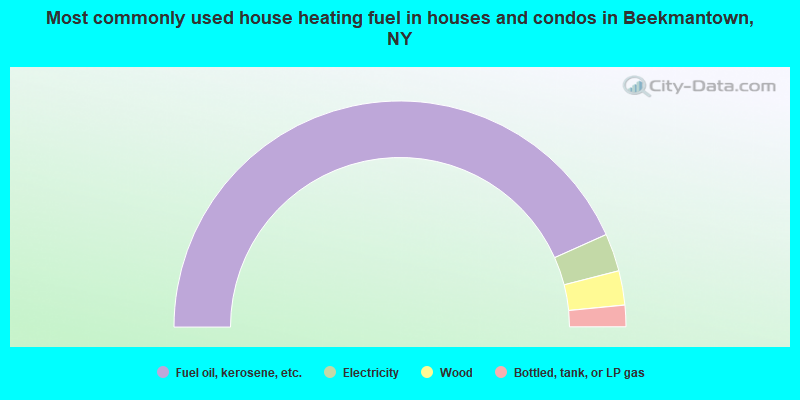
- 86.6%Fuel oil, kerosene, etc.
- 5.4%Electricity
- 4.9%Wood
- 3.1%Bottled, tank, or LP gas
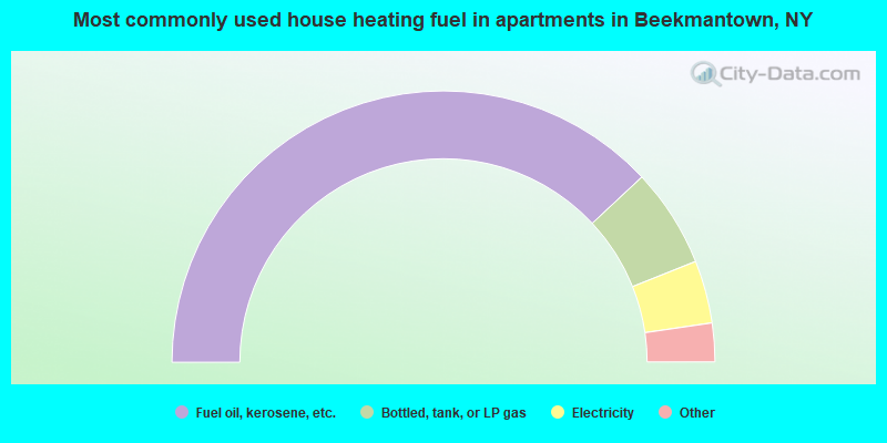
- 76.1%Fuel oil, kerosene, etc.
- 11.8%Bottled, tank, or LP gas
- 7.5%Electricity
- 2.6%Utility gas
- 2.0%Wood
Beekmantown compared to New York state average:
- Median house value below state average.
- Unemployed percentage below state average.
- Black race population percentage significantly below state average.
- Hispanic race population percentage significantly below state average.
- Foreign-born population percentage significantly below state average.
- Renting percentage significantly below state average.
- Length of stay since moving in significantly above state average.
- Number of rooms per house significantly below state average.
- House age significantly below state average.
- Number of college students below state average.
Beekmantown on our top lists:
- #5 on the list of "Top 101 cities with largest percentage of males in industries: sewing, needlework, and piece goods stores (population 5,000+)"
- #7 on the list of "Top 101 cities with largest percentage of females in industries: hardware, plumbing and heating equipment, and supplies merchant wholesalers (population 5,000+)"
- #8 on the list of "Top 101 cities with largest percentage of males in occupations: nursing, psychiatric, and home health aides (population 5,000+)"
- #8 on the list of "Top 101 cities with largest percentage of females in industries: sewing, needlework, and piece goods stores (population 5,000+)"
- #13 on the list of "Top 101 cities with largest percentage of females in occupations: other health diagnosing and treating practitioners and technical occupations (population 5,000+)"
- #26 on the list of "Top 101 cities with largest percentage of males in occupations: other construction workers and helpers (population 5,000+)"
- #26 on the list of "Top 101 cities with largest percentage of females in occupations: special education teachers (population 5,000+)"
- #32 on the list of "Top 101 cities with largest percentage of males in occupations: laborers and material movers, hand (population 5,000+)"
- #32 on the list of "Top 101 cities with largest percentage of females in industries: electrical equipment, appliances, and components (population 5,000+)"
- #33 on the list of "Top 101 cities with largest percentage of males in occupations: child care workers (population 5,000+)"
- #33 on the list of "Top 101 cities with largest percentage of males in industries: professional and commercial equipment and supplies merchant wholesalers (population 5,000+)"
- #38 on the list of "Top 101 cities with largest percentage of males in industries: water transportation (population 5,000+)"
- #46 on the list of "Top 101 cities with largest percentage of males in industries: petroleum and coal products (population 5,000+)"
- #53 on the list of "Top 101 cities with largest percentage of females in industries: u. s. postal service (population 5,000+)"
- #56 on the list of "Top 101 cities with largest percentage of males in industries: health care (population 5,000+)"
- #63 on the list of "Top 101 cities with largest percentage of females in industries: chemicals (population 5,000+)"
- #66 on the list of "Top 101 cities with largest percentage of females in industries: religious, grantmaking, civic, professional, and similar organizations (population 5,000+)"
- #82 on the list of "Top 101 cities with largest percentage of males in industries: chemicals (population 5,000+)"
- #89 on the list of "Top 101 cities with largest percentage of males in industries: paper (population 5,000+)"
- #95 on the list of "Top 101 cities with largest percentage of males in industries: food (population 5,000+)"
- #26 on the list of "Top 101 counties with the largest number of people moving out compared to moving in (pop. 50,000+)"
- #45 on the list of "Top 101 counties with the lowest percentage of residents relocating from other counties between 2010 and 2011"
- #100 on the list of "Top 101 counties with the lowest percentage of residents relocating to other counties in 2011"