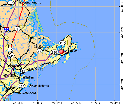
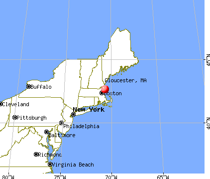
Gloucester, Massachusetts
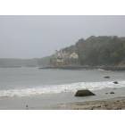
Gloucester: A House With A View

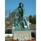
Gloucester: Man at the wheel
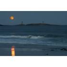
Gloucester: Moon Rise Over Thachers Island
Gloucester: Fisherman Memorial
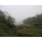
Gloucester: Gloucester Field by the Sea
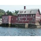
Gloucester: Copper Paint Manufacturary
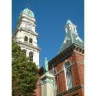
Gloucester: Gloucester City Hall

Gloucester: Sun Set From Eastern Point Light
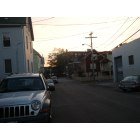
Gloucester: Cedar St. Gloucester MA
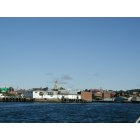
Gloucester: Here is a picture of inner city Gloucester, Massachusetts.
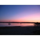
Gloucester: Niles beach at sunset
- see
35
more - add
your
Submit your own pictures of this city and show them to the world
- OSM Map
- General Map
- Google Map
- MSN Map
Population change since 2000: -1.4%
 |
| Males: 14,699 | |
| Females: 15,137 |
| Median resident age: | 51.4 years |
| Massachusetts median age: | 40.3 years |
Zip codes: 01930.
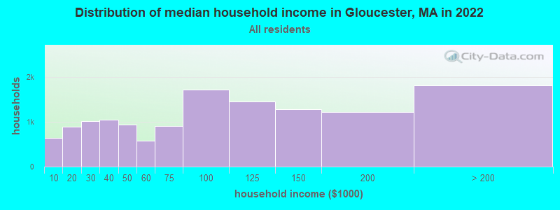
| Gloucester: | $82,706 |
| MA: | $94,488 |
Estimated per capita income in 2022: $51,307 (it was $25,595 in 2000)
Gloucester city income, earnings, and wages data
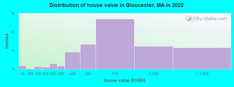
Estimated median house or condo value in 2022: $580,583 (it was $203,400 in 2000)
| Gloucester: | $580,583 |
| MA: | $534,700 |
Mean prices in 2022: all housing units: $780,910; detached houses: $782,474; townhouses or other attached units: over $1,000,000; in 2-unit structures: $864,974; in 3-to-4-unit structures: $445,899; in 5-or-more-unit structures: $323,672
Median gross rent in 2022: $1,490.
(9.9% for White Non-Hispanic residents, 10.9% for Black residents, 18.1% for Hispanic or Latino residents, 19.4% for other race residents, 21.5% for two or more races residents)
Detailed information about poverty and poor residents in Gloucester, MA


Compare current foreclosures near Gloucester, MA:
| Photo | Address | Area | Beds / Baths | Price | Details |
|---|---|---|---|---|---|

|
#1
Willow St
Gloucester, MA 01930
|
1,698 sq. feet
|
1 baths 3 beds |
show details | |

|
#2
Brooks Rd
Gloucester, MA 01930
|
1,149 sq. feet
|
1 baths 2 beds |
show details | |

|
#3
Thatcher Rd
Gloucester, MA 01930
|
2,824 sq. feet
|
2 baths 2 beds |
show details | |

|
#4
Pearl St
Gloucester, MA 01930
|
1,156 sq. feet
|
1 baths 3 beds |
show details | |

|
#5
Ellery St
Gloucester, MA 01930
|
3,140 sq. feet
|
2 baths 3 beds |
show details | |

|
#6
Burnham St
Gloucester, MA 01930
|
1,152 sq. feet
|
2 baths 3 beds |
show details | |

|
#7
Old Farm Ln
Gloucester, MA 01930
|
2,162 sq. feet
|
3 baths 5 beds |
show details | |

|
#8
Perkins St
Gloucester, MA 01930
|
1,105 sq. feet
|
1 baths 4 beds |
show details | |

|
#9
Washington St Apt 4
Gloucester, MA 01930
|
778 sq. feet
|
1 baths 2 beds |
show details | |

|
#10
Western Ave
Gloucester, MA 01930
|
1,998 sq. feet
|
3 baths 2 beds |
show details |
| Photo | Address | Area | Beds / Baths | Price | Details |
|---|---|---|---|---|---|

|
#11
Kent Rd
Gloucester, MA 01930
|
- sq. feet
|
- baths - beds |
show details | |

|
#12
Day Ct
Gloucester, MA 01930
|
- sq. feet
|
- baths - beds |
show details | |

|
#13
Eastern Point Rd
Gloucester, MA 01930
|
1,272 sq. feet
|
- baths - beds |
show details | |

|
#14
Essex St
Swampscott, MA 01907
|
2,029 sq. feet
|
2 baths 3 beds |
show details | |

|
#15
Chase St
Beverly, MA 01915
|
1,407 sq. feet
|
1 baths 3 beds |
show details | |

|
#16
Merrill Ave
Lynn, MA 01902
|
1,136 sq. feet
|
1 baths 3 beds |
show details | |

|
#17
Mill River Ln
Rowley, MA 01969
|
2,705 sq. feet
|
2 baths 4 beds |
show details | |

|
#18
Farnham Rd
Rowley, MA 01969
|
1,106 sq. feet
|
2 baths 3 beds |
show details | |

|
#19
Flint St
Danvers, MA 01923
|
1,923 sq. feet
|
2 baths 4 beds |
show details | |

|
#20
Foster St Un 307
Peabody, MA 01960
|
510 sq. feet
|
1 baths 1 beds |
show details |
| Photo | Address | Area | Beds / Baths | Price | Details |
|---|---|---|---|---|---|

|
#21
64th St
Newburyport, MA 01950
|
1,517 sq. feet
|
2 baths 2 beds |
show details | |

|
#22
Collins St
Danvers, MA 01923
|
2,516 sq. feet
|
2 baths 3 beds |
show details | |

|
#23
Homestead Way
Topsfield, MA 01983
|
2,105 sq. feet
|
2 baths 5 beds |
show details | |

|
#24
Ethel Ave
Peabody, MA 01960
|
4,238 sq. feet
|
3 baths 8 beds |
show details | |

|
#25
Buena Vista Ave
Salem, MA 01970
|
1,843 sq. feet
|
3 baths 3 beds |
show details | |

|
#26
Prince St
Danvers, MA 01923
|
1,352 sq. feet
|
1 baths 3 beds |
show details | |

|
#27
Orchard Avenue
Peabody, MA 01960
|
2,668 sq. feet
|
3 baths 4 beds |
show details | |

|
#28
Collins St
Danvers, MA 01923
|
1,729 sq. feet
|
2 baths 2 beds |
show details | |

|
#29
Calumet St
Peabody, MA 01960
|
2,288 sq. feet
|
2 baths 6 beds |
show details | |

|
#30
Greenway Rd
Salem, MA 01970
|
1,584 sq. feet
|
1 baths 3 beds |
show details |
| Photo | Address | Area | Beds / Baths | Price | Details |
|---|---|---|---|---|---|

|
#31
Barrett Rd
Peabody, MA 01960
|
1,536 sq. feet
|
2 baths 3 beds |
show details | |

|
#32
Lawrence Rd Un 22
Rowley, MA 01969
|
720 sq. feet
|
1 baths 1 beds |
show details | |

|
#33
Knights Ct
Newbury, MA 01951
|
4,057 sq. feet
|
3 baths 5 beds |
show details | |

|
#34
Ruby Ave
Marblehead, MA 01945
|
2,644 sq. feet
|
2 baths 10 beds |
show details | |

|
#35
Jacobs St
Peabody, MA 01960
|
2,679 sq. feet
|
2 baths 6 beds |
show details | |

|
#36
Endicott St
Peabody, MA 01960
|
1,573 sq. feet
|
2 baths 5 beds |
show details | |

|
#37
Ord St
Salem, MA 01970
|
1,365 sq. feet
|
1 baths 2 beds |
show details | |

|
#38
Village Rd Apt 210
Middleton, MA 01949
|
769 sq. feet
|
1 baths 1 beds |
show details | |

|
#39
Holten St Apt 8
Danvers, MA 01923
|
620 sq. feet
|
1 baths 2 beds |
show details | |

|
#40
Monroe Rd
Salem, MA 01970
|
1,292 sq. feet
|
1 baths 3 beds |
show details |
| Photo | Address | Area | Beds / Baths | Price | Details |
|---|---|---|---|---|---|

|
#41
Sylvan St
Danvers, MA 01923
|
1,996 sq. feet
|
2 baths 3 beds |
show details | |

|
#42
Boston St # 2
Salem, MA 01970
|
1,683 sq. feet
|
2 baths 2 beds |
show details | |

|
#43
Auburndale Rd
Marblehead, MA 01945
|
2,536 sq. feet
|
2 baths 3 beds |
show details | |

|
#44
Phillips St
Salem, MA 01970
|
2,075 sq. feet
|
2 baths 2 beds |
show details | |

|
#45
Prince St
Danvers, MA 01923
|
1,352 sq. feet
|
1 baths 3 beds |
show details | |

|
#46
Coolidge Ave
Peabody, MA 01960
|
2,573 sq. feet
|
2 baths 4 beds |
show details | |

|
#47
Crosby St
Salem, MA 01970
|
1,920 sq. feet
|
2 baths 2 beds |
show details | |

|
#48
Dexter St
Peabody, MA 01960
|
1,626 sq. feet
|
2 baths 4 beds |
show details | |

|
#49
Bartholomew St
Peabody, MA 01960
|
960 sq. feet
|
1 baths 3 beds |
show details | |

|
Check over 1 million property listings on Foreclosure.com!
|
browse all offers | |||


- 25,75186.3%White alone
- 1,2954.3%Hispanic
- 8302.8%Two or more races
- 8122.7%Asian alone
- 3811.3%Black alone
- 480.2%Other race alone
- 290.10%American Indian alone
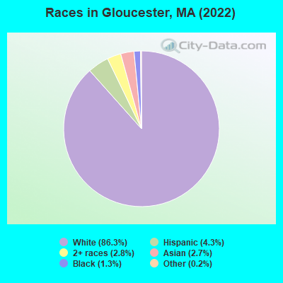
Races in Gloucester detailed stats: ancestries, foreign born residents, place of birth
According to our research of Massachusetts and other state lists, there were 14 registered sex offenders living in Gloucester, Massachusetts as of May 07, 2024.
The ratio of all residents to sex offenders in Gloucester is 2,137 to 1.
The ratio of registered sex offenders to all residents in this city is lower than the state average.
Type |
2009 |
2010 |
2011 |
2012 |
2013 |
2014 |
2015 |
2016 |
2017 |
2018 |
2019 |
2020 |
2021 |
2022 |
|---|---|---|---|---|---|---|---|---|---|---|---|---|---|---|
| Murders (per 100,000) | 0 (0.0) | 0 (0.0) | 0 (0.0) | 0 (0.0) | 0 (0.0) | 0 (0.0) | 0 (0.0) | 0 (0.0) | 0 (0.0) | 0 (0.0) | 0 (0.0) | 0 (0.0) | 0 (0.0) | 0 (0.0) |
| Rapes (per 100,000) | 2 (6.5) | 0 (0.0) | 6 (20.7) | 4 (13.7) | 9 (30.6) | 4 (13.5) | 2 (6.7) | 4 (13.4) | 4 (13.3) | 8 (26.4) | 8 (26.3) | 11 (36.1) | 4 (12.9) | 14 (46.2) |
| Robberies (per 100,000) | 8 (26.1) | 4 (13.9) | 1 (3.5) | 0 (0.0) | 0 (0.0) | 6 (20.3) | 6 (20.1) | 4 (13.4) | 7 (23.3) | 3 (9.9) | 1 (3.3) | 4 (13.1) | 2 (6.5) | 5 (16.5) |
| Assaults (per 100,000) | 21 (68.5) | 28 (97.3) | 15 (51.8) | 23 (78.6) | 13 (44.2) | 81 (273.5) | 63 (211.2) | 65 (217.9) | 70 (233.5) | 61 (200.9) | 50 (164.7) | 57 (187.2) | 45 (145.3) | 54 (178.2) |
| Burglaries (per 100,000) | 93 (303.2) | 86 (298.7) | 82 (283.1) | 40 (136.6) | 33 (112.3) | 51 (172.2) | 32 (107.3) | 21 (70.4) | 19 (63.4) | 33 (108.7) | 21 (69.2) | 11 (36.1) | 22 (71.1) | 29 (95.7) |
| Thefts (per 100,000) | 531 (1,731) | 557 (1,935) | 466 (1,609) | 372 (1,271) | 345 (1,174) | 178 (601.1) | 176 (590.0) | 193 (646.9) | 183 (610.4) | 168 (553.4) | 130 (428.2) | 76 (249.6) | 139 (448.9) | 123 (405.9) |
| Auto thefts (per 100,000) | 5 (16.3) | 4 (13.9) | 5 (17.3) | 4 (13.7) | 5 (17.0) | 11 (37.1) | 16 (53.6) | 15 (50.3) | 7 (23.3) | 16 (52.7) | 13 (42.8) | 9 (29.6) | 21 (67.8) | 15 (49.5) |
| Arson (per 100,000) | 1 (3.3) | 3 (10.4) | 0 (0.0) | 0 (0.0) | 0 (0.0) | 2 (6.8) | 1 (3.4) | 2 (6.7) | 1 (3.3) | 2 (6.6) | 0 (0.0) | 1 (3.3) | 1 (3.2) | 4 (13.2) |
| City-Data.com crime index | 118.5 | 123.0 | 113.5 | 88.1 | 89.5 | 110.7 | 89.0 | 93.1 | 95.1 | 98.2 | 80.4 | 85.2 | 69.7 | 104.5 |
The City-Data.com crime index weighs serious crimes and violent crimes more heavily. Higher means more crime, U.S. average is 246.1. It adjusts for the number of visitors and daily workers commuting into cities.
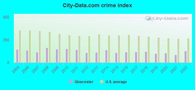
Crime rate in Gloucester detailed stats: murders, rapes, robberies, assaults, burglaries, thefts, arson
Full-time law enforcement employees in 2021, including police officers: 69 (62 officers - 60 male; 2 female).
| Officers per 1,000 residents here: | 2.00 |
| Massachusetts average: | 2.53 |
 Recent articles from our blog. Our writers, many of them Ph.D. graduates or candidates, create easy-to-read articles on a wide variety of topics.

 | Questions about Gloucester/Marblehead (13 replies) |
| How is Gloucester for young couple? (17 replies) |
| Retiring in a lower-priced town? (94 replies) |
| Question about Lack of Real Estate Inventory North Shore (5 replies) |
| My 2019 Thanksgiving in Massachusetts: I'am surprised the turkey did not stand up and say 'i want to move too' (221 replies) |
| Gloucester-- family friendly? (10 replies) |
Latest news from Gloucester, MA collected exclusively by city-data.com from local newspapers, TV, and radio stations
Gloucester, MA City Guides:
Ancestries: Italian (21.4%), Irish (13.6%), English (9.3%), Portuguese (7.4%), American (4.6%), German (3.7%).
Current Local Time: EST time zone
Elevation: 50 feet
Land area: 26.0 square miles.
Population density: 1,149 people per square mile (low).
2,888 residents are foreign born (2.9% Latin America, 2.9% Europe, 1.7% Asia, 1.3% Africa).
| This city: | 9.7% |
| Massachusetts: | 17.6% |
Median real estate property taxes paid for housing units with mortgages in 2022: $5,518 (1.0%)
Median real estate property taxes paid for housing units with no mortgage in 2022: $6,229 (1.0%)
Nearest city with pop. 50,000+: Lynn, MA  (17.6 miles , pop. 89,050).
Nearest city with pop. 200,000+: Boston, MA (29.7 miles , pop. 589,141).
Nearest city with pop. 1,000,000+: Bronx, NY (205.8 miles , pop. 1,332,650).
Nearest cities:
), ), Latitude: 42.62 N, Longitude: 70.68 W
Daytime population change due to commuting: -1,169 (-3.9%)
Workers who live and work in this city: 8,025 (52.4%)
Area codes: 978, 508
Gloucester tourist attractions:
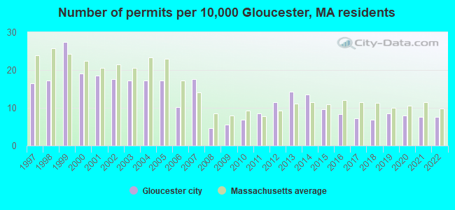
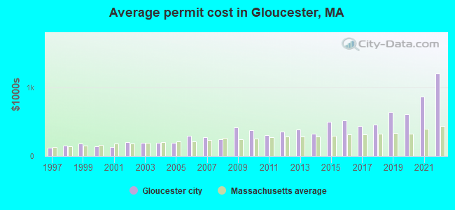
Single-family new house construction building permits:
- 2022: 23 buildings, average cost: $1,202,500
- 2021: 23 buildings, average cost: $865,100
- 2020: 24 buildings, average cost: $614,300
- 2019: 26 buildings, average cost: $640,600
- 2018: 21 buildings, average cost: $457,500
- 2017: 22 buildings, average cost: $439,400
- 2016: 25 buildings, average cost: $515,500
- 2015: 29 buildings, average cost: $502,400
- 2014: 41 buildings, average cost: $329,900
- 2013: 43 buildings, average cost: $387,000
- 2012: 35 buildings, average cost: $358,900
- 2011: 26 buildings, average cost: $301,500
- 2010: 21 buildings, average cost: $376,300
- 2009: 17 buildings, average cost: $419,700
- 2008: 14 buildings, average cost: $242,100
- 2007: 53 buildings, average cost: $271,700
- 2006: 31 buildings, average cost: $295,100
- 2005: 52 buildings, average cost: $191,900
- 2004: 52 buildings, average cost: $192,500
- 2003: 52 buildings, average cost: $189,400
- 2002: 53 buildings, average cost: $205,100
- 2001: 56 buildings, average cost: $130,900
- 2000: 58 buildings, average cost: $141,300
- 1999: 83 buildings, average cost: $179,300
- 1998: 52 buildings, average cost: $151,200
- 1997: 50 buildings, average cost: $118,500
| Here: | 3.8% |
| Massachusetts: | 3.5% |
Population change in the 1990s: +1,525 (+5.3%).
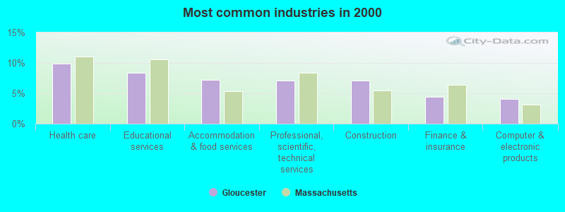
- Health care (9.9%)
- Educational services (8.4%)
- Accommodation & food services (7.2%)
- Professional, scientific, technical services (7.1%)
- Construction (7.1%)
- Finance & insurance (4.4%)
- Computer & electronic products (4.1%)
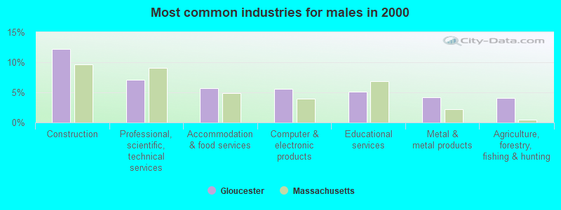
- Construction (12.2%)
- Professional, scientific, technical services (7.1%)
- Accommodation & food services (5.7%)
- Computer & electronic products (5.6%)
- Educational services (5.1%)
- Metal & metal products (4.1%)
- Agriculture, forestry, fishing & hunting (4.1%)
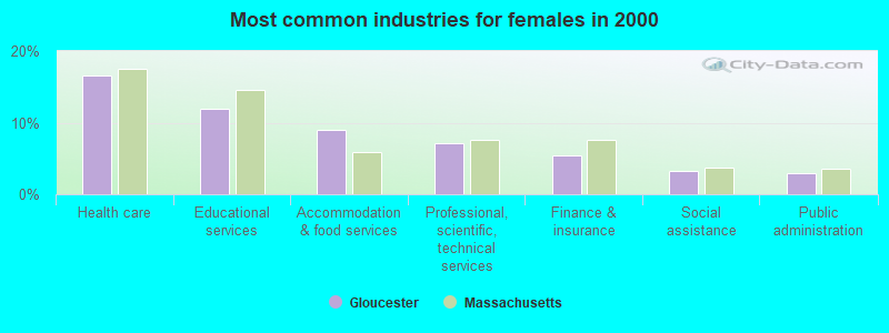
- Health care (16.5%)
- Educational services (12.0%)
- Accommodation & food services (9.0%)
- Professional, scientific, technical services (7.2%)
- Finance & insurance (5.5%)
- Social assistance (3.3%)
- Public administration (3.0%)
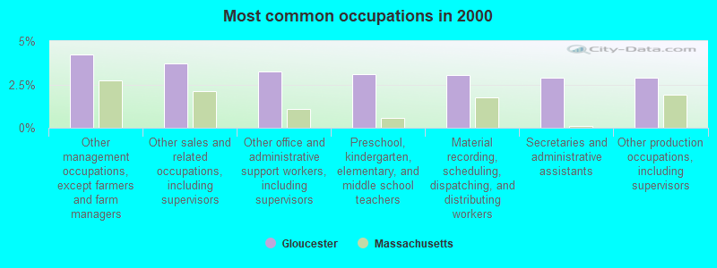
- Other management occupations, except farmers and farm managers (4.2%)
- Other sales and related occupations, including supervisors (3.7%)
- Other office and administrative support workers, including supervisors (3.2%)
- Preschool, kindergarten, elementary, and middle school teachers (3.1%)
- Material recording, scheduling, dispatching, and distributing workers (3.0%)
- Secretaries and administrative assistants (2.9%)
- Other production occupations, including supervisors (2.9%)
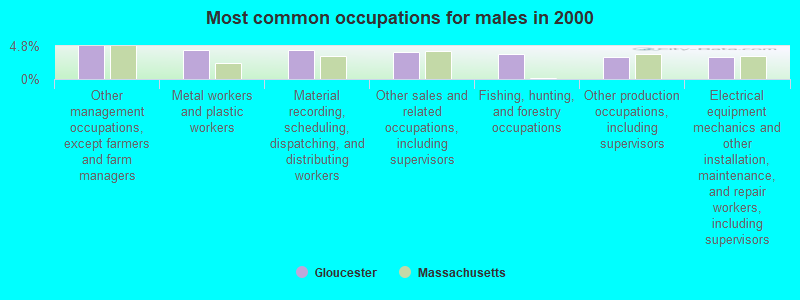
- Other management occupations, except farmers and farm managers (4.8%)
- Metal workers and plastic workers (4.2%)
- Material recording, scheduling, dispatching, and distributing workers (4.2%)
- Other sales and related occupations, including supervisors (4.0%)
- Fishing, hunting, and forestry occupations (3.6%)
- Other production occupations, including supervisors (3.2%)
- Electrical equipment mechanics and other installation, maintenance, and repair workers, including supervisors (3.2%)
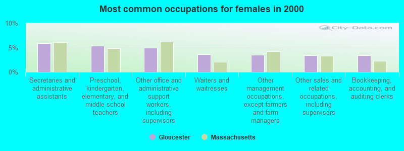
- Secretaries and administrative assistants (5.9%)
- Preschool, kindergarten, elementary, and middle school teachers (5.3%)
- Other office and administrative support workers, including supervisors (4.9%)
- Waiters and waitresses (3.6%)
- Other management occupations, except farmers and farm managers (3.5%)
- Other sales and related occupations, including supervisors (3.4%)
- Bookkeeping, accounting, and auditing clerks (3.4%)
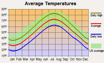
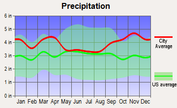
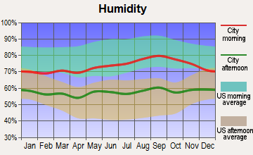
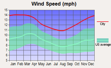
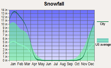
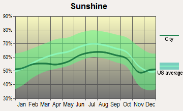
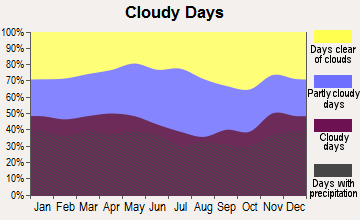
Average climate in Gloucester, Massachusetts
Based on data reported by over 4,000 weather stations
|
|

(lower is better)
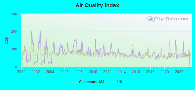
Air Quality Index (AQI) level in 2022 was 70.7. This is about average.
| City: | 70.7 |
| U.S.: | 72.6 |
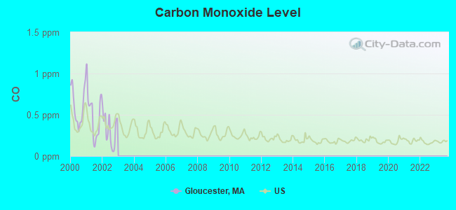
Carbon Monoxide (CO) [ppm] level in 2002 was 0.319. This is worse than average. Closest monitor was 24.7 miles away from the city center.
| City: | 0.319 |
| U.S.: | 0.251 |
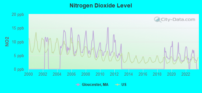
Nitrogen Dioxide (NO2) [ppb] level in 2022 was 5.41. This is about average. Closest monitor was 12.8 miles away from the city center.
| City: | 5.41 |
| U.S.: | 5.11 |
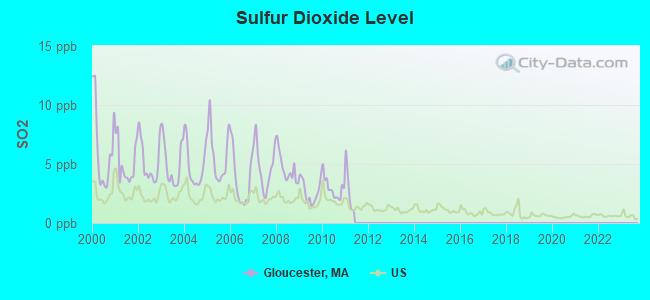
Sulfur Dioxide (SO2) [ppb] level in 2010 was 2.94. This is significantly worse than average. Closest monitor was 7.9 miles away from the city center.
| City: | 2.94 |
| U.S.: | 1.51 |
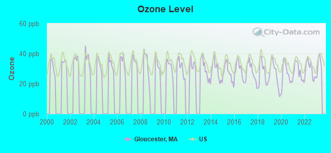
Ozone [ppb] level in 2022 was 29.2. This is about average. Closest monitor was 1.7 miles away from the city center.
| City: | 29.2 |
| U.S.: | 33.3 |
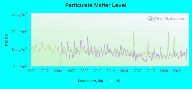
Particulate Matter (PM2.5) [µg/m3] level in 2022 was 6.45. This is better than average. Closest monitor was 18.3 miles away from the city center.
| City: | 6.45 |
| U.S.: | 8.11 |
Tornado activity:
Gloucester-area historical tornado activity is below Massachusetts state average. It is 58% smaller than the overall U.S. average.
On 9/29/1974, a category F3 (max. wind speeds 158-206 mph) tornado 26.7 miles away from the Gloucester city center injured one person and caused between $50,000 and $500,000 in damages.
On 6/9/1953, a category F3 tornado 28.2 miles away from the city center injured 5 people and caused between $5000 and $50,000 in damages.
Earthquake activity:
Gloucester-area historical earthquake activity is significantly above Massachusetts state average. It is 74% smaller than the overall U.S. average.On 10/16/2012 at 23:12:25, a magnitude 4.7 (4.7 ML, Depth: 10.0 mi, Class: Light, Intensity: IV - V) earthquake occurred 67.3 miles away from Gloucester center
On 4/20/2002 at 10:50:47, a magnitude 5.3 (5.3 ML, Depth: 3.0 mi, Class: Moderate, Intensity: VI - VII) earthquake occurred 200.0 miles away from the city center
On 1/19/1982 at 00:14:42, a magnitude 4.7 (4.5 MB, 4.7 MD, 4.5 LG) earthquake occurred 76.5 miles away from the city center
On 10/7/1983 at 10:18:46, a magnitude 5.3 (5.1 MB, 5.3 LG, 5.1 ML) earthquake occurred 206.2 miles away from Gloucester center
On 4/20/2002 at 10:50:47, a magnitude 5.2 (5.2 MB, 4.2 MS, 5.2 MW, 5.0 MW) earthquake occurred 199.6 miles away from the city center
On 8/22/1992 at 12:20:32, a magnitude 4.8 (4.8 MB, 3.8 MS, 4.7 LG, Depth: 6.2 mi) earthquake occurred 244.0 miles away from Gloucester center
Magnitude types: regional Lg-wave magnitude (LG), body-wave magnitude (MB), duration magnitude (MD), local magnitude (ML), surface-wave magnitude (MS), moment magnitude (MW)
Natural disasters:
The number of natural disasters in Essex County (33) is a lot greater than the US average (15).Major Disasters (Presidential) Declared: 20
Emergencies Declared: 13
Causes of natural disasters: Floods: 14, Storms: 11, Hurricanes: 6, Snowstorms: 5, Winter Storms: 5, Snows: 3, Blizzards: 2, Fire: 1, Heavy Rain: 1, Snowfall: 1, Water Main Break: 1, Wind: 1 (Note: some incidents may be assigned to more than one category).
Main business address for: VARIAN SEMICONDUCTOR EQUIPMENT ASSOCIATES INC (SPECIAL INDUSTRY MACHINERY, NEC).
Hospitals and medical centers in Gloucester:
Heliports located in Gloucester:
- Nugent Heliport (MA13)
- Pond Road Heliport (MA15)
- U S C G Heliport (MA42)
- Wheeler's Point Heliport (MA14)
Colleges/universities with over 2000 students nearest to Gloucester:
- Endicott College (about 10 miles; Beverly, MA; Full-time enrollment: 4,064)
- Salem State University (about 14 miles; Salem, MA; FT enrollment: 8,027)
- North Shore Community College (about 16 miles; Danvers, MA; FT enrollment: 5,195)
- Northern Essex Community College (about 23 miles; Haverhill, MA; FT enrollment: 4,737)
- Merrimack College (about 24 miles; North Andover, MA; FT enrollment: 2,734)
- Bunker Hill Community College (about 27 miles; Boston, MA; FT enrollment: 8,814)
- Suffolk University (about 27 miles; Boston, MA; FT enrollment: 6,982)
Public high school in Gloucester:
- GLOUCESTER HIGH (Students: 1,244, Location: 32 L O JOHNSON RD, Grades: 9-12)
Public elementary/middle schools in Gloucester:
- RALPH B O'MALEY MIDDLE (Students: 815, Location: 32 CHERRY STREET, Grades: 6-8)
- WEST PARISH (Students: 365, Location: 10 CONCORD STREET, Grades: KG-5)
- EAST GLOUCESTER ELEMENTARY (Students: 241, Location: 8 DAVIS ST EXT, Grades: KG-5)
- VETERANS MEMORIAL (Students: 225, Location: 11 WEBSTER STREET, Grades: KG-5)
- BEEMAN MEMORIAL (Students: 215, Location: 138 CHERRY STREET, Grades: KG-5)
- PLUM COVE SCHOOL (Students: 103, Location: 15 HICKORY STREET, Grades: KG-5)
Private elementary/middle schools in Gloucester:
User-submitted facts and corrections:
- Addison-Gilbert is another hospital in the City of Gloucester
- Please add: St. Paul Lutheran Church, Lanesville
Points of interest:
Notable locations in Gloucester: Blackburn Industrial Park (A), Cape Ann Industrial Park (B), Kettle Cove Industrial Park (C), Eastern Point Light (D), Tenpound Island Light (E), West Gloucester Station (F), Gloucester Station (G), YMCA Camp (H), Bass Rocks Country Club (I), Tenpound Island Lighthouse (J), Grant Circle (K), Blackburn Circle (L), Rocky Neck Art Colony (M), Gloucester Fishermens Museum (N), Sargent-Murray-Gilmon-Hough House (O), Cape Ann Chamber of Commerce (P), Fitz Hugh Lane House (Q), North Shore Art Association (R), Beauport Museum (S), Annisquam Historical Society Building (T). Display/hide their locations on the map
Shopping Center: East Gloucester Shopping Center (1). Display/hide its location on the map
Main business address in Gloucester: VARIAN SEMICONDUCTOR EQUIPMENT ASSOCIATES INC (A). Display/hide its location on the map
Churches in Gloucester include: West Gloucester Church (A), Lanesville Congregational Church (B), Saint Johns Episcopal Church (C), Gloucester Community Church (D), First Church of Christ Scientist (E), Cape Ann Bible Church (F), Assembly of God Church (G), Annisquam Village Church (H). Display/hide their locations on the map
Cemeteries: Seaside Cemetery (1), Old Bridge Street Burying Ground (2), Cherry Hill Cemetery (3), Oak Hill Cemetery (4), Wesleyan Cemetery (5), Oak Grove Cemetery (6), Calvary Cemetery (7). Display/hide their locations on the map
Lakes, reservoirs, and swamps: Niles Pond (A), Langsford Pond (B), Sleepy Hollow Pond (C), Dykes Pond (D), Upper Banjo Pond (E), Wallace Pond (F), West Pond (G), Lily Pond (H). Display/hide their locations on the map
Streams, rivers, and creeks: Farm Creek (A), Alewife Brook (B), Jones River (C), Little River (D), Lanes Creek (E), Mill River (F). Display/hide their locations on the map
Parks in Gloucester include: Fishermens Monument (1), Hidden Park (2), Captain Solomon Jacobs Park (3), Central Gloucester Historic District (4), Mount Ann Park (5), Burke Playground (6), Ravenswood Park (7), State Fort Park (8), Gloucester Fisherman Statue (9). Display/hide their locations on the map
Beaches: Wingaersheek Beach (A), Halfmoon Beach (B), Niles Beach (C), Pavilion Beach (D), Cressy Beach (E), Good Harbor Beach (F). Display/hide their locations on the map
Tourist attractions: Cape Ann Historical Association (Museums; 27 Pleasant Street) (1), Gloucester Adventure (Museums; 4 Harbor Loop) (2), Gloucester Maritime Heritage Center (Museums; 9 Harbor Loop) (3), Brown Richard K (Museums; 75 Eastern Point Boulevard) (4), Beauport House (Museums; 75 Eastern Point Blvd) (5), Hammond Castle Museum (Cultural Attractions- Events- & Facilities; 80 Hesperus Avenue) (6), McMullan J A (Cultural Attractions- Events- & Facilities; 75 Eastern Point Boulevard) (7), 7 Seas Whale Watching (7 Seas Wharf) (8), Gloucester Visitor Information Center (80 Western Avenue) (9). Display/hide their approximate locations on the map
Hotels: Gofer Time Services (51 Eastern Point Road) (1), Ocean View Inn (171 Atlantic Road) (2), Inn at Babson Court (53 Western Avenue) (3), Good Harbor Beach Inn Inc (1 Salt Island Road) (4), Julietta House-Bed & Breakfast (84 Prospect Street) (5), Fairview Inn (52 Eastern Point Road) (6), Best Western Bass Rocks Ocean (107 Atlantic Road) (7), Cape Ann Marina - Office (75 Essex Ave) (8), Bed & Breakfast Reservations NORE GRTR Bstn CPE CD (11 Beach Road) (9). Display/hide their approximate locations on the map
Court: Rockport-Gloucester District Court (197 Main Street) (1). Display/hide its approximate location on the map
Birthplace of: William Stacy - Continental Army officer, Marc Randazza - Blogger, Alexander Gordon Lyle - Navy Medal of Honor recipient, Benjamin A. Smith II - Politician, Clarence Wilkinson - Politician, Fred Doe - Baseball player, Josh Gates - Explorer, Roger Babson - Entrepreneur and business theorist, Russ Russo - Film actor, Stuffy McInnis - MLB player and manager.
Drinking water stations with addresses in Gloucester and their reported violations in the past:
GLOUCESTER DPW WATER DEPT. (Population served: 36,267, Surface water):Past health violations:Past monitoring violations:
- MCL, Monthly (TCR) - In SEP-2009, Contaminant: Coliform. Follow-up actions: St AO (w/o penalty) issued (AUG-21-2009)
- MCL, Monthly (TCR) - In AUG-2009, Contaminant: Coliform. Follow-up actions: St AO (w/o penalty) issued (AUG-21-2009)
- Follow-up Or Routine LCR Tap M/R - In OCT-01-2005, Contaminant: Lead and Copper Rule. Follow-up actions: St AO (w/o penalty) issued (JAN-27-2006), St Compliance achieved (AUG-25-2006)
- One routine major monitoring violation
- 76 regular monitoring violations
| This city: | 2.3 people |
| Massachusetts: | 2.5 people |
| This city: | 60.2% |
| Whole state: | 63.0% |
| This city: | 6.9% |
| Whole state: | 7.0% |
Likely homosexual households (counted as self-reported same-sex unmarried-partner households)
- Lesbian couples: 0.6% of all households
- Gay men: 0.4% of all households
People in group quarters in Gloucester in 2010:
- 216 people in nursing facilities/skilled-nursing facilities
- 127 people in other noninstitutional facilities
- 41 people in emergency and transitional shelters (with sleeping facilities) for people experiencing homelessness
- 26 people in residential treatment centers for adults
- 23 people in group homes intended for adults
- 14 people in residential treatment centers for juveniles (non-correctional)
- 3 people in military barracks and dormitories (nondisciplinary)
People in group quarters in Gloucester in 2000:
- 265 people in nursing homes
- 69 people in other noninstitutional group quarters
- 18 people in other nonhousehold living situations
- 8 people in other group homes
Banks with branches in Gloucester (2011 data):
- RBS Citizens, National Association: Gloucester, Main Street Branch at 147 Main Street, branch established on 1796/01/01; Gloucester Stop & Shop Branch at 6 Thatcher Road, branch established on 2004/07/22. Info updated 2007/09/19: Bank assets: $106,940.6 mil, Deposits: $75,690.2 mil, headquarters in Providence, RI, positive income, 1135 total offices, Holding Company: Uk Financial Investments Limited
- TD Bank, National Association: Washington Street Branch at 224 Washington Street, branch established on 1999/04/19; Gloucester Bank & Trust Branch at 2 Harbor Loop, branch established on 1987/01/02. Info updated 2010/10/04: Bank assets: $188,912.6 mil, Deposits: $153,149.8 mil, headquarters in Wilmington, DE, positive income, 1314 total offices, Holding Company: Toronto-Dominion Bank, The
- Cape Ann Savings Bank: at 109 Main Street, branch established on 1846/04/15; Gloucester High School Branch at Leslie O. Johnson Road, branch established on 1990/09/13. Info updated 2006/09/29: Bank assets: $425.4 mil, Deposits: $313.2 mil, local headquarters, positive income, 3 total offices
- Sovereign Bank, National Association: Gloucester Branch at 154 Main Street, branch established on 1891/01/01. Info updated 2012/01/31: Bank assets: $78,146.9 mil, Deposits: $48,042.9 mil, headquarters in Wilmington, DE, positive income, Commercial Lending Specialization, 718 total offices, Holding Company: Banco Santander, S.A.
- The First National Bank of Ipswich: Gloucester Branch at 207 Main Street, branch established on 1980/05/01. Info updated 2010/06/01: Bank assets: $282.6 mil, Deposits: $223.7 mil, headquarters in Ipswich, MA, positive income, Commercial Lending Specialization, 6 total offices, Holding Company: Brookline Bancorp, Inc.
- The Rockport National Bank: Parker St. Branch at 4 Parker St., branch established on 2007/06/13. Info updated 2006/11/03: Bank assets: $178.8 mil, Deposits: $160.2 mil, headquarters in Rockport, MA, positive income, Commercial Lending Specialization, 5 total offices, Holding Company: Rockport National Bancorp, Inc.
- BankGloucester: Bankgloucester at 160 Main Street, branch established on 1887/01/01. Info updated 2009/07/21: Bank assets: $179.6 mil, Deposits: $138.6 mil, local headquarters, positive income, Commercial Lending Specialization, 1 total offices
For population 15 years and over in Gloucester:
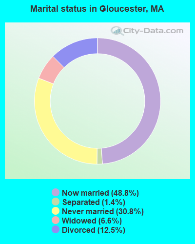
- Never married: 30.8%
- Now married: 48.8%
- Separated: 1.4%
- Widowed: 6.6%
- Divorced: 12.5%
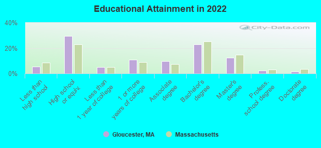
For population 25 years and over in Gloucester:
- High school or higher: 94.6%
- Bachelor's degree or higher: 39.6%
- Graduate or professional degree: 16.3%
- Unemployed: 3.7%
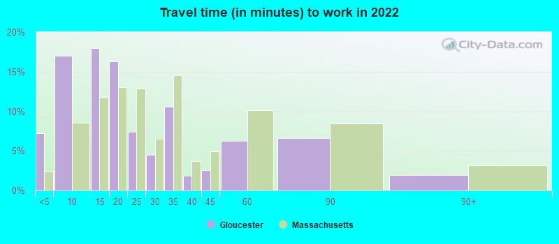
- Mean travel time to work (commute): 21.5 minutes
| Here: | 10.9 |
| Massachusetts average: | 13.0 |


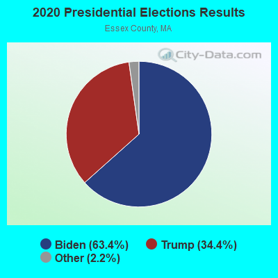
Graphs represent county-level data. Detailed 2008 Election Results
Neighborhoods in Gloucester:
(Gloucester, Massachusetts Neighborhood Map)Religion statistics for Gloucester, MA (based on Essex County data)


| Religion | Adherents | Congregations |
|---|---|---|
| Catholic | 341,970 | 55 |
| Mainline Protestant | 33,710 | 140 |
| Evangelical Protestant | 20,925 | 160 |
| Other | 15,882 | 63 |
| Orthodox | 11,590 | 13 |
| Black Protestant | 376 | 3 |
| None | 318,706 | - |
Food Environment Statistics:
| This county: | 1.98 / 10,000 pop. |
| State: | 1.98 / 10,000 pop. |
| Essex County: | 0.04 / 10,000 pop. |
| Massachusetts: | 0.05 / 10,000 pop. |
| Here: | 1.97 / 10,000 pop. |
| State: | 2.22 / 10,000 pop. |
| Here: | 1.30 / 10,000 pop. |
| State: | 1.77 / 10,000 pop. |
| Here: | 7.60 / 10,000 pop. |
| Massachusetts: | 8.76 / 10,000 pop. |
| This county: | 8.4% |
| Massachusetts: | 8.1% |
| Here: | 23.7% |
| State: | 22.5% |
| Here: | 20.7% |
| State: | 16.5% |
Health and Nutrition:
| Gloucester: | 49.6% |
| State: | 50.5% |
| Gloucester: | 45.9% |
| Massachusetts: | 48.0% |
| Gloucester: | 28.4 |
| Massachusetts: | 28.4 |
| Here: | 21.0% |
| Massachusetts: | 20.7% |
| This city: | 9.0% |
| State: | 10.4% |
| Gloucester: | 6.8 |
| Massachusetts: | 6.8 |
| Gloucester: | 34.6% |
| Massachusetts: | 33.4% |
| Here: | 55.5% |
| Massachusetts: | 57.1% |
| Gloucester: | 77.5% |
| State: | 79.2% |
More about Health and Nutrition of Gloucester, MA Residents
| Local government employment and payroll (March 2022) | |||||
| Function | Full-time employees | Monthly full-time payroll | Average yearly full-time wage | Part-time employees | Monthly part-time payroll |
|---|---|---|---|---|---|
| Elementary and Secondary - Instruction | 442 | $2,589,833 | $70,312 | 74 | $196,726 |
| Police Protection - Officers | 74 | $678,395 | $110,010 | 0 | $0 |
| Elementary and Secondary - Other Total | 74 | $331,800 | $53,805 | 69 | $198,382 |
| Firefighters | 71 | $675,542 | $114,176 | 0 | $0 |
| Other and Unallocable | 59 | $368,810 | $75,012 | 25 | $39,984 |
| Financial Administration | 26 | $208,659 | $96,304 | 0 | $0 |
| Streets and Highways | 19 | $148,745 | $93,944 | 0 | $0 |
| Other Government Administration | 16 | $91,006 | $68,255 | 0 | $0 |
| Health | 16 | $61,224 | $45,918 | 0 | $0 |
| Water Supply | 15 | $47,164 | $37,731 | 0 | $0 |
| Local Libraries | 14 | $68,478 | $58,695 | 2 | $2,341 |
| Sewerage | 8 | $23,401 | $35,102 | 0 | $0 |
| Welfare | 6 | $30,572 | $61,144 | 0 | $0 |
| Water Transport and Terminals | 5 | $29,649 | $71,158 | 0 | $0 |
| Judicial and Legal | 3 | $27,359 | $109,436 | 0 | $0 |
| Police - Other | 3 | $15,676 | $62,704 | 0 | $0 |
| Totals for Government | 851 | $5,396,313 | $76,094 | 170 | $437,433 |
Gloucester government finances - Expenditure in 2021 (per resident):
- Construction - General - Other: $1,966,000 ($65.89)
Elementary and Secondary Education: $1,659,000 ($55.60)
Water Utilities: $1,289,000 ($43.20)
Regular Highways: $1,233,000 ($41.33)
Sewerage: $1,199,000 ($40.19)
- Current Operations - Elementary and Secondary Education: $57,776,000 ($1936.45)
General - Other: $33,033,000 ($1107.15)
Local Fire Protection: $9,784,000 ($327.93)
Police Protection: $7,281,000 ($244.03)
Sewerage: $6,369,000 ($213.47)
Water Utilities: $4,765,000 ($159.71)
Solid Waste Management: $2,226,000 ($74.61)
Financial Administration: $2,095,000 ($70.22)
Libraries: $1,189,000 ($39.85)
Regular Highways: $1,151,000 ($38.58)
Protective Inspection and Regulation - Other: $699,000 ($23.43)
Housing and Community Development: $533,000 ($17.86)
Health - Other: $512,000 ($17.16)
Central Staff Services: $484,000 ($16.22)
Sea and Inland Port Facilities: $446,000 ($14.95)
Public Welfare - Other: $417,000 ($13.98)
Judicial and Legal Services: $347,000 ($11.63)
Parks and Recreation: $274,000 ($9.18)
Natural Resources - Other: $92,000 ($3.08)
- General - Interest on Debt: $3,184,000 ($106.72)
- Intergovernmental to Local - Other - Elementary and Secondary Education: $4,131,000 ($138.46)
Other - Central Staff Services: $16,000 ($0.54)
Other - Health - Other: $12,000 ($0.40)
- Intergovernmental to State - Transit Utilities: $379,000 ($12.70)
General - Other: $59,000 ($1.98)
- Other Capital Outlay - General - Other: $3,857,000 ($129.27)
Sewerage: $2,446,000 ($81.98)
Water Utilities: $1,530,000 ($51.28)
Elementary and Secondary Education: $1,389,000 ($46.55)
Local Fire Protection: $168,000 ($5.63)
Police Protection: $126,000 ($4.22)
Sea and Inland Port Facilities: $43,000 ($1.44)
Regular Highways: $32,000 ($1.07)
General Public Building: $18,000 ($0.60)
Parks and Recreation: $2,000 ($0.07)
- Total Salaries and Wages: $34,779,000 ($1165.67)
- Water Utilities - Interest on Debt: $1,053,000 ($35.29)
Gloucester government finances - Revenue in 2021 (per resident):
- Charges - Sewerage: $8,449,000 ($283.18)
Other: $3,966,000 ($132.93)
Parks and Recreation: $2,798,000 ($93.78)
Solid Waste Management: $1,289,000 ($43.20)
Sea and Inland Port Facilities: $555,000 ($18.60)
Elementary and Secondary Education School Lunch: $371,000 ($12.43)
Housing and Community Development: $294,000 ($9.85)
Elementary and Secondary Education - Other: $168,000 ($5.63)
Elementary and Secondary Education School Tuition and Transportation: $153,000 ($5.13)
- Federal Intergovernmental - Other: $12,792,000 ($428.74)
Education: $2,082,000 ($69.78)
Housing and Community Development: $305,000 ($10.22)
- Local Intergovernmental - Education: $234,000 ($7.84)
- Miscellaneous - General Revenue - Other: $796,000 ($26.68)
Donations From Private Sources: $390,000 ($13.07)
Fines and Forfeits: $368,000 ($12.33)
Interest Earnings: $48,000 ($1.61)
- Revenue - Water Utilities: $6,690,000 ($224.23)
- State Intergovernmental - Education: $12,036,000 ($403.41)
General Local Government Support: $4,443,000 ($148.91)
Highways: $3,439,000 ($115.26)
Other: $2,029,000 ($68.01)
Public Welfare: $253,000 ($8.48)
Water Utilities: $216,000 ($7.24)
Sewerage: $11,000 ($0.37)
- Tax - Property: $94,767,000 ($3176.26)
Other License: $1,977,000 ($66.26)
Other Selective Sales: $1,506,000 ($50.48)
Gloucester government finances - Debt in 2021 (per resident):
- Long Term Debt - Beginning Outstanding - Unspecified Public Purpose: $140,099,000 ($4695.64)
Outstanding Unspecified Public Purpose: $134,607,000 ($4511.56)
Retired Unspecified Public Purpose: $14,832,000 ($497.12)
Issue, Unspecified Public Purpose: $9,340,000 ($313.04)
- Short Term Debt Outstanding - End of Fiscal Year: $22,368,000 ($749.70)
Beginning: $12,355,000 ($414.10)
Gloucester government finances - Cash and Securities in 2021 (per resident):
- Bond Funds - Cash and Securities: $10,593,000 ($355.04)
- Other Funds - Cash and Securities: $35,067,000 ($1175.33)
5.09% of this county's 2021 resident taxpayers lived in other counties in 2020 ($96,821 average adjusted gross income)
| Here: | 5.09% |
| Massachusetts average: | 6.35% |
0.01% of residents moved from foreign countries ($21 average AGI)
Essex County: 0.01% Massachusetts average: 0.01%
Top counties from which taxpayers relocated into this county between 2020 and 2021:
| from Middlesex County, MA | |
| from Suffolk County, MA | |
| from Rockingham County, NH |
5.47% of this county's 2020 resident taxpayers moved to other counties in 2021 ($95,440 average adjusted gross income)
| Here: | 5.47% |
| Massachusetts average: | 7.18% |
0.01% of residents moved to foreign countries ($53 average AGI)
Essex County: 0.01% Massachusetts average: 0.02%
Top counties to which taxpayers relocated from this county between 2020 and 2021:
| to Middlesex County, MA | |
| to Rockingham County, NH | |
| to Suffolk County, MA |
| Businesses in Gloucester, MA | ||||
| Name | Count | Name | Count | |
|---|---|---|---|---|
| 7-Eleven | 2 | McDonald's | 1 | |
| Ace Hardware | 1 | New Balance | 1 | |
| Blockbuster | 1 | Penske | 1 | |
| Chevrolet | 1 | RadioShack | 1 | |
| DHL | 1 | Rite Aid | 1 | |
| Decora Cabinetry | 2 | SAS Shoes | 1 | |
| Domino's Pizza | 1 | Shaw's | 2 | |
| Dunkin Donuts | 5 | Sprint Nextel | 1 | |
| FedEx | 5 | Stop & Shop | 1 | |
| GNC | 1 | T-Mobile | 1 | |
| GameStop | 1 | U-Haul | 1 | |
| H&R Block | 1 | UPS | 3 | |
| Marshalls | 1 | Vans | 1 | |
| MasterBrand Cabinets | 8 | YMCA | 1 | |
Strongest AM radio stations in Gloucester:
- WRKO (680 AM; 50 kW; BOSTON, MA; Owner: ENTERCOM BOSTON LICENSE, LLC)
- WBZ (1030 AM; 50 kW; BOSTON, MA; Owner: INFINITY BROADCASTING OPERATIONS, INC.)
- WEEI (850 AM; 50 kW; BOSTON, MA; Owner: ENTERCOM BOSTON LICENSE, LLC)
- WWZN (1510 AM; 50 kW; BOSTON, MA; Owner: ROSE CITY RADIO CORPORATION)
- WKOX (1200 AM; 50 kW; FRAMINGHAM, MA; Owner: CAPSTAR TX LIMITED PARTNERSHIP)
- WBIX (1060 AM; 40 kW; NATICK, MA; Owner: LANGER BROADCASTING CORPORATION)
- WNSH (1570 AM; 5 kW; BEVERLY, MA)
- WRCA (1330 AM; 25 kW; WALTHAM, MA; Owner: WRCA LICENSE, LLC)
- WAMG (890 AM; 25 kW; DEDHAM, MA; Owner: MEGA COMMUNICATIONS OF DEDHAM LICENSEE, LLC)
- WCRN (830 AM; 50 kW; WORCESTER, MA; Owner: CARTER BROADCASTING CORPORATION)
- WROL (950 AM; 5 kW; BOSTON, MA; Owner: SCA LICENSE CORPORATION)
- WEZE (590 AM; 5 kW; BOSTON, MA; Owner: NEW ENGLAND CONTINENTAL MEDIA, INC.)
- WALE (990 AM; 50 kW; GREENVILLE, RI; Owner: NORTH AMERICAN BROADCASTING CO., INC.)
Strongest FM radio stations in Gloucester:
- WBOQ (104.9 FM; GLOUCESTER, MA; Owner: MARLIN BROADCASTING, LLC)
- WQSX (93.7 FM; LAWRENCE, MA; Owner: ENTERCOM BOSTON LICENSE, LLC)
- WXKS-FM (107.9 FM; MEDFORD, MA; Owner: AMFM RADIO LICENSES, L.L.C.)
- WMJX (106.7 FM; BOSTON, MA; Owner: GREATER BOSTON RADIO, INC.)
- WXRV (92.5 FM; HAVERHILL, MA; Owner: BEANPOT BROADCASTING CORP.)
- WBMX (98.5 FM; BOSTON, MA; Owner: INFINITY RADIO OPERATIONS INC.)
- WJMN (94.5 FM; BOSTON, MA; Owner: AMFM RADIO LICENSES, L.L.C.)
- WBOS (92.9 FM; BROOKLINE, MA; Owner: GREATER BOSTON RADIO, INC.)
- WCRB (102.5 FM; WALTHAM, MA; Owner: CHARLES RIVER BROADCASTING WCRB LICE)
- WTKK (96.9 FM; BOSTON, MA; Owner: GREATER BOSTON RADIO, INC.)
- WROR-FM (105.7 FM; FRAMINGHAM, MA; Owner: GREATER BOSTON RADIO, INC.)
- W267AI (101.3 FM; BOSTON, MA; Owner: MCC BROADCASTING COMPANY, INC.)
- WBCN (104.1 FM; BOSTON, MA; Owner: HEMISPHERE BROADCASTING CORPORATION)
- WZLX (100.7 FM; BOSTON, MA; Owner: INFINITY BROADCASTING CORPORATION OF BOSTON)
- WGBH (89.7 FM; BOSTON, MA; Owner: WGBH EDUCATIONAL FOUNDATION)
- WBUR-FM (90.9 FM; BOSTON, MA; Owner: TRUSTEES OF BOSTON UNIVERSITY)
- WERS (88.9 FM; BOSTON, MA; Owner: EMERSON COLLEGE)
- WKLB-FM (99.5 FM; LOWELL, MA; Owner: GREATER BOSTON RADIO, INC.)
- WODS (103.3 FM; BOSTON, MA; Owner: INFINITY BROADCASTING OPERATIONS, INC.)
- WHRB (95.3 FM; CAMBRIDGE, MA; Owner: HARVARD RADIO BROADCASTING CO., INC.)
TV broadcast stations around Gloucester:
- WCVB-TV (Channel 5; BOSTON, MA; Owner: WCVB HEARST-ARGYLE TV, INC.)
- WHDN-LP (Channel 26; BOSTON, MA; Owner: GUENTER MARKSTEINER)
- WGBH-TV (Channel 2; BOSTON, MA; Owner: WGBH EDUCATIONAL FOUNDATION)
- WHDH-TV (Channel 7; BOSTON, MA; Owner: WHDH-TV)
- WBPX (Channel 68; BOSTON, MA; Owner: PAXSON BOSTON-68 LICENSE, INC.)
- WMFP (Channel 62; LAWRENCE, MA; Owner: WSAH LICENSE, INC.)
- WFXZ-CA (Channel 24; BOSTON, MA; Owner: BOSTON BROADCASTING CORP.)
- WSBK-TV (Channel 38; BOSTON, MA; Owner: VIACOM INC.)
- WLVI-TV (Channel 56; CAMBRIDGE, MA; Owner: WLVI, INC.)
- WBZ-TV (Channel 4; BOSTON, MA; Owner: VIACOM INC.)
- WGBX-TV (Channel 44; BOSTON, MA; Owner: WGBH EDUCATIONAL FOUNDATION)
- WFXT (Channel 25; BOSTON, MA; Owner: FOX TELEVISION STATIONS INC.)
- WTMU-LP (Channel 32; BOSTON, MA; Owner: ZGS BOSTON, INC.)
- WCEA-LP (Channel 58; BOSTON, MA; Owner: CHANNEL 19 TV CORPORATION)
- WUTF (Channel 66; MARLBOROUGH, MA; Owner: TELEFUTURA BOSTON LLC)
- WMEA-TV (Channel 26; BIDDEFORD, ME; Owner: MAINE PUBLIC BROADCASTING CORP.)
- W40BO (Channel 40; BOSTON, MA; Owner: PAXSON COMMUNICATIONS LPTV, INC.)
Medal of Honor Recipients
Medal of Honor Recipient born in Gloucester: Alexander Gordon Lyle.
- National Bridge Inventory (NBI) Statistics
- 15Number of bridges
- 164ft / 50.4mTotal length
- $60,316,000Total costs
- 330,290Total average daily traffic
- 19,249Total average daily truck traffic
- 494,921Total future (year 2031) average daily traffic
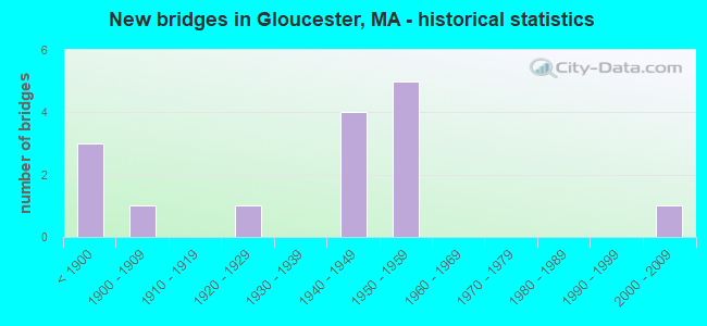
- New bridges - historical statistics
- 3Before 1900
- 11900-1909
- 11920-1929
- 41940-1949
- 51950-1959
- 12000-2009
FCC Registered Antenna Towers: 75 (See the full list of FCC Registered Antenna Towers)
FCC Registered Private Land Mobile Towers: 7 (See the full list of FCC Registered Private Land Mobile Towers in Gloucester, MA)
FCC Registered Broadcast Land Mobile Towers: 12 (See the full list of FCC Registered Broadcast Land Mobile Towers)
FCC Registered Microwave Towers: 9 (See the full list of FCC Registered Microwave Towers in this town)
FCC Registered Paging Towers: 10 (See the full list of FCC Registered Paging Towers)
FCC Registered Maritime Coast & Aviation Ground Towers: 11 (See the full list of FCC Registered Maritime Coast & Aviation Ground Towers)
FCC Registered Amateur Radio Licenses: 203 (See the full list of FCC Registered Amateur Radio Licenses in Gloucester)
FAA Registered Aircraft: 13 (See the full list of FAA Registered Aircraft in Gloucester)
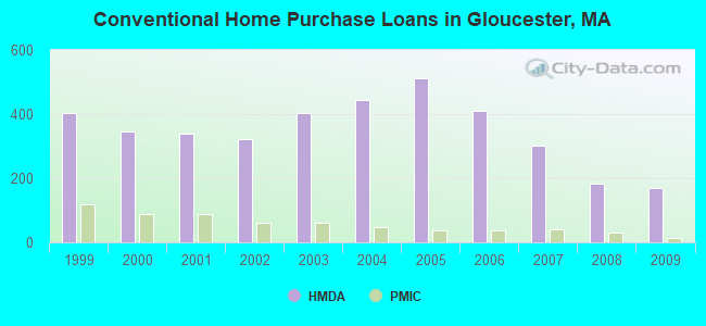
| Home Mortgage Disclosure Act Aggregated Statistics For Year 2009 (Based on 8 full tracts) | ||||||||||||
| A) FHA, FSA/RHS & VA Home Purchase Loans | B) Conventional Home Purchase Loans | C) Refinancings | D) Home Improvement Loans | E) Loans on Dwellings For 5+ Families | F) Non-occupant Loans on < 5 Family Dwellings (A B C & D) | |||||||
|---|---|---|---|---|---|---|---|---|---|---|---|---|
| Number | Average Value | Number | Average Value | Number | Average Value | Number | Average Value | Number | Average Value | Number | Average Value | |
| LOANS ORIGINATED | 54 | $259,444 | 171 | $250,526 | 885 | $265,521 | 80 | $168,650 | 5 | $304,600 | 130 | $338,962 |
| APPLICATIONS APPROVED, NOT ACCEPTED | 8 | $240,625 | 16 | $339,375 | 72 | $239,000 | 8 | $27,125 | 0 | $0 | 9 | $357,000 |
| APPLICATIONS DENIED | 17 | $284,647 | 32 | $252,125 | 223 | $284,417 | 19 | $127,842 | 0 | $0 | 26 | $279,923 |
| APPLICATIONS WITHDRAWN | 11 | $221,000 | 29 | $221,828 | 156 | $278,929 | 4 | $213,250 | 1 | $400,000 | 15 | $199,133 |
| FILES CLOSED FOR INCOMPLETENESS | 1 | $201,000 | 7 | $186,143 | 44 | $253,023 | 2 | $137,500 | 0 | $0 | 3 | $328,333 |
Detailed HMDA statistics for the following Tracts: 2211.00 , 2213.00, 2214.00, 2215.00, 2216.00, 2217.00, 2218.00, 2219.00
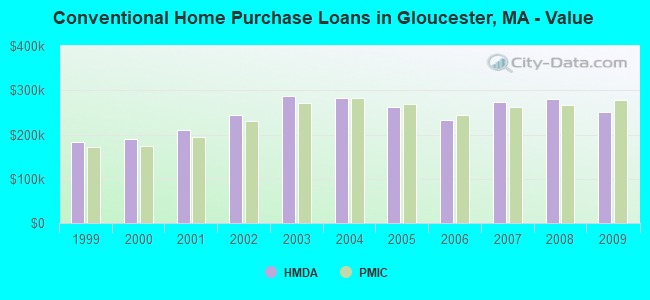
| Private Mortgage Insurance Companies Aggregated Statistics For Year 2009 (Based on 7 full tracts) | ||||||
| A) Conventional Home Purchase Loans | B) Refinancings | C) Non-occupant Loans on < 5 Family Dwellings (A & B) | ||||
|---|---|---|---|---|---|---|
| Number | Average Value | Number | Average Value | Number | Average Value | |
| LOANS ORIGINATED | 12 | $278,833 | 8 | $301,500 | 2 | $208,000 |
| APPLICATIONS APPROVED, NOT ACCEPTED | 0 | $0 | 6 | $327,667 | 0 | $0 |
| APPLICATIONS DENIED | 7 | $263,286 | 4 | $296,000 | 1 | $266,000 |
| APPLICATIONS WITHDRAWN | 0 | $0 | 3 | $268,667 | 0 | $0 |
| FILES CLOSED FOR INCOMPLETENESS | 0 | $0 | 0 | $0 | 0 | $0 |
Detailed PMIC statistics for the following Tracts: 2211.00 , 2213.00, 2214.00, 2215.00, 2216.00, 2217.00, 2218.00, 2219.00
2002 - 2018 National Fire Incident Reporting System (NFIRS) incidents
- Fire incident types reported to NFIRS in Gloucester, MA
- 1,25652.9%Structure Fires
- 78232.9%Outside Fires
- 1988.3%Mobile Property/Vehicle Fires
- 1395.9%Other
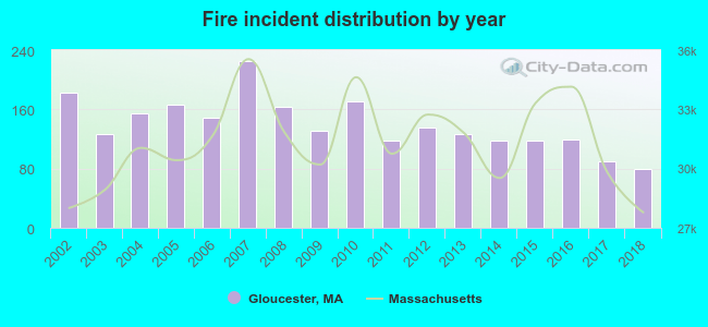 Based on the data from the years 2002 - 2018 the average number of fires per year is 140. The highest number of fire incidents - 225 took place in 2007, and the least - 79 in 2018. The data has a dropping trend.
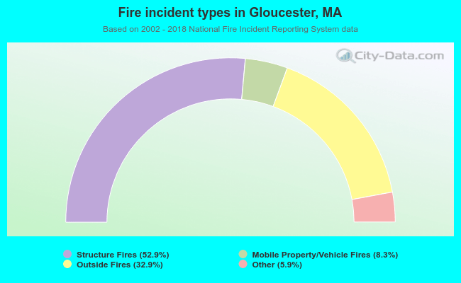 When looking into fire subcategories, the most incidents belonged to: Structure Fires (52.9%), and Outside Fires (32.9%).
| Most common first names in Gloucester, MA among deceased individuals | ||
| Name | Count | Lived (average) |
|---|---|---|
| Mary | 405 | 81.7 years |
| John | 353 | 74.9 years |
| Joseph | 233 | 74.5 years |
| William | 203 | 73.5 years |
| Robert | 180 | 70.6 years |
| James | 163 | 73.7 years |
| Margaret | 159 | 81.1 years |
| Charles | 154 | 75.7 years |
| George | 146 | 76.3 years |
| Helen | 143 | 82.1 years |
| Most common last names in Gloucester, MA among deceased individuals | ||
| Last name | Count | Lived (average) |
|---|---|---|
| Johnson | 85 | 75.3 years |
| Silva | 80 | 78.3 years |
| Brown | 78 | 78.1 years |
| Smith | 71 | 81.6 years |
| Parsons | 68 | 78.0 years |
| Anderson | 64 | 78.5 years |
| Perry | 55 | 79.7 years |
| Davis | 50 | 75.3 years |
| Tarr | 48 | 78.1 years |
| Parisi | 45 | 76.0 years |
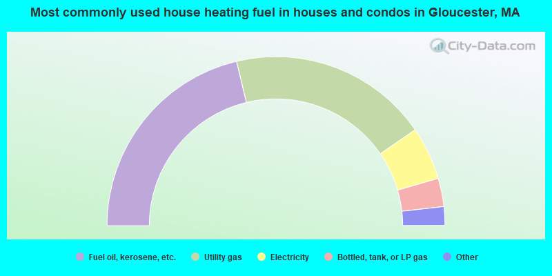
- 42.5%Fuel oil, kerosene, etc.
- 38.3%Utility gas
- 10.2%Electricity
- 5.4%Bottled, tank, or LP gas
- 1.2%Solar energy
- 1.1%Wood
- 1.1%Other fuel
- 0.1%No fuel used
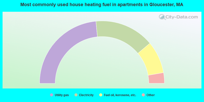
- 46.9%Utility gas
- 30.9%Electricity
- 16.7%Fuel oil, kerosene, etc.
- 2.7%Bottled, tank, or LP gas
- 1.3%No fuel used
- 1.0%Other fuel
- 0.4%Wood
- 0.1%Solar energy
Gloucester compared to Massachusetts state average:
- Unemployed percentage significantly below state average.
- Black race population percentage significantly below state average.
- Hispanic race population percentage significantly below state average.
- Median age above state average.
- Foreign-born population percentage below state average.
- Length of stay since moving in significantly above state average.
- Number of college students below state average.
Gloucester on our top lists:
- #31 on the list of "Top 101 cities with the biggest property tax revenues per resident (population 10,000+)"
- #71 on the list of "Top 101 cities with the most residents born in Portugal (population 500+)"
- #94 on the list of "Top 101 cities with the biggest local government total salary and wages expenses per resident (population 10,000+)"
- #100 on the list of "Top 101 cities where residents moved in more then 10 years ago (10,000+ households)"
- #67 (01930) on the list of "Top 101 zip codes with the most museums in 2005"
- #21 on the list of "Top 101 counties with the lowest percentage of residents that keep firearms around their homes"
- #21 on the list of "Top 101 counties with the most Orthodox adherents"
- #23 on the list of "Top 101 counties with the highest carbon monoxide air pollution readings in 2012 (ppm)"
- #30 on the list of "Top 101 counties with the most Catholic adherents"
- #36 on the list of "Top 101 counties with the most Orthodox congregations (pop. 50,000+)"

|
|
Total of 569 patent applications in 2008-2024.